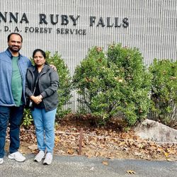
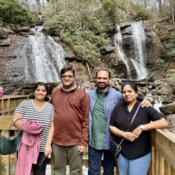
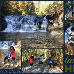
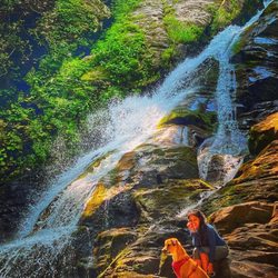
Hogpen Gap Photos


More like Hogpen Gap
Recommended Reviews - Hogpen Gap
Start your review...

If you plan to tackle the Appalachian Trail, head on over to Hogpen Gap. Between 13 and 14 miles is the distance for it. Some people have told me 13.4 miles, others say 13.8, I just say 14 and round it off. This is one way. I would suggest you either have a friend who parked at Unicoi Gap and drive with you to Hogpen Gap so you both could hike it. Otherwise, remember you have to walk back to your car afterwards so that's 14 x 2 = 28 miles. Hogpen Gap does has its own parking lot, so does Unicop Gap. Honestly, I would've never thought to tackle this trail without the support of my job. We were walking for a charity event and each miles per person = a dollar donation for Gigi's Playhouse. You can see it all on the news here, our journey. The video is here http://www.fox5atlanta.com/recipebox/270043868-video The article is here http://www.fox5atlanta.com/good-day/269973657-story I just want to say kudos to those who want to tackle the AT!! It is rough in some areas. Overall, the trail is moderate but some parts are strenuous with inclines of boulders. There are areas for camping and water (literally water running down the stream, many take filter water bottles). We actually met a lady who was doing the trail solo and camping. I find it amazing that people do have that passion. Honestly, I can proudly say that I've done this trail. It was tough in the past few miles. I was okay up until 11.5 miles. After that, my legs felt like jello. It took roughly 7.5 hours to finish it. More than halfway on the trail, you can see the birth of the Chattahoochee River, from a small stream that heads towards Atlanta. Whoever thought! Stay on the white trail. If you see a blue trail, it means it's an off trail. The white trail means you're still on the AT. If you see two double white lines, it means you will make a sharp turn. 103/2017 read more


9 years ago
More info about Hogpen Gap
Richard B Scenic Hwy
Helen, GA 30545
Directions
Visit Website
http://www.georgiatrails.com
Hours
Outdoor Amenities


Hogpen Gap - hiking - Updated June 2026
Best of Helen
People found Hogpen Gap by searching for…
Hiking Trails in Helen, Georgia
Tent Camping in Helen, Georgia
Things to Do in Helen, Georgia
Running Trails in Helen, Georgia
Off Road Trails in Helen, Georgia
Waterfalls and Swimming Holes in Helen, Georgia
Camping Sites in Helen, Georgia
Paved Walking Trails in Helen, Georgia
Places to Take Pictures in Helen, Georgia
Camping Cabins in Helen, Georgia
Watch Sunset in Helen, Georgia
Stroller Friendly Hikes in Helen, Georgia
Lookout Points in Helen, Georgia
Fun Things to Do With Kids in Helen, Georgia
Trending Searches in Helen, GA
Black Owned Nail Salons near Hogpen Gap
Dog Friendly Trails near Hogpen Gap
Jet Ski Rental near Hogpen Gap
Off Road Trails near Hogpen Gap
Outdoor Activities near Hogpen Gap
River Swimming near Hogpen Gap
Scenic Overlook near Hogpen Gap
Secluded Spots near Hogpen Gap
Strawberry Picking near Hogpen Gap
Swimming Holes near Hogpen Gap
Browse Articles
Browse Nearby
Browse Brands
Related Searches in Helen, GA
Affordable Kayak Rental Services in Helen, Georgia
Best Fishing Locations and Guides in Helen, Georgia
Best Nature Trails for Hiking in Helen, Georgia
Best Places for Horseback Riding in Helen, Georgia
Best Waterfalls and Swimming Holes in Helen, Georgia
Check Out Off Road Trails in Helen, Georgia
Discover Dog Friendly Trails to Explore in Helen, Georgia
Discover Kid Friendly Hiking Trails in Helen, Georgia
Discover Scenic Mountain Bike Trails Near Helen, Georgia
Discover Scenic Waterfall Spots in Helen, Georgia
Discover a Hiking Trail in Helen, Georgia
Discover the Best Night Hike Trails in Helen, Georgia
Discover the Best Running Track in Helen, Georgia
Dog-Friendly Hikes With Dogs in Helen, Georgia
Enjoy Camping Adventures Around Helen, Georgia
Enjoy Exciting Mountain Biking Adventures in Helen, Georgia
Enjoy Kayaking Adventures in Helen, Georgia
Enjoy River Tubing Adventures in Helen, Georgia
Enjoy Tent Camping Spots Around Helen, Georgia
Enjoy a Beautiful Waterfall Hike in Helen, Georgia
Enjoy the Best Family Activities in Helen, Georgia
Enjoy the Best Picnic Spots and Ideas in Helen, Georgia
Enjoy the Best Tubing Experiences in Helen, Georgia
Enjoy the Best Walking Trails in Helen, Georgia
Exciting Cliff Jumping Spots in Helen, Georgia
Experience Thrilling White Water Rafting in Helen, Georgia
Explore Beautiful Parks and Green Spaces in Helen, Georgia
Explore Easy Hikes Perfect for All in Helen, Georgia
Explore Fun Activities to Do in Helen, Georgia
Explore Popular Campgrounds Near Helen, Georgia
Explore Popular Scenic Overlook Points in Helen, Georgia
Explore the Best Boating Spots in Helen, Georgia
Explore the Best Swimming Holes Around Helen, Georgia
Explore the Best Trail Options in Helen, Georgia
Family Friendly Hiking With Kids in Helen, Georgia
Find Cozy Camping Cabins in Helen, Georgia
Find Popular Ziplining Spots Around Helen, Georgia
Find the Best Playgrounds to Visit in Helen, Georgia
Find the Best Scenic View Locations in Helen, Georgia
Hiking Trails With Waterfalls in Helen, Georgia
Off Leash Dog Hiking Trails in Helen, Georgia
Plan a Scenic Drive Route Near Helen, Georgia
Popular Outdoor Activities to Try in Helen, Georgia
Popular Things to Do in Helen, Georgia
Top Climbing Spots and Gyms in Helen, Georgia
Top Paddleboarding Activities in Helen, Georgia
Top Places for Snorkeling in Helen, Georgia
Top Running Trails to Explore in Helen, Georgia