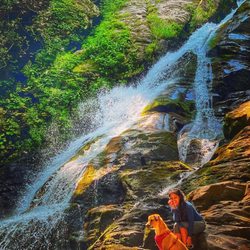
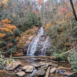
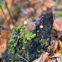
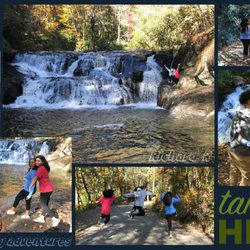
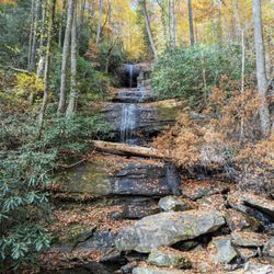
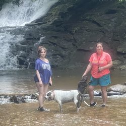
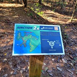
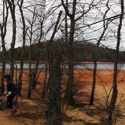
Blue Ridge Gap Photos


More like Blue Ridge Gap
Recommended Reviews - Blue Ridge Gap
Start your review...

Review is for the last trail of the Appalachian Mountain in GA to NC. Blue Ridge Gap to Bly Gap You could check out the YouTube video to visually see more about the trail https://www.youtube.com/watch?v=JDavhW82d-I Note - GPS pin is 34.9512103, -83.6261231 but that is not the beginning of the trail. It is for church that is 2 miles down the road. You will need a Four Wheeler or truck to make it to the trail head. Or you could definitely walk there. Lots of boulders on this trail once you are off the main road, it's an incline going up. I was fortunate to adventure on this trail with my job. Collaborating with Vestigo has helped me learn about the Appalachian Trails. This is supposed to be the easiest one on the trail. Believe me, it is not "easy." I would rate it moderate with the inclines, especially in the beginning of the trail. Most of the trail is dirt with not many tree roots. You will see a sign for GA/NC border. Once you get there, it will not be far to reach Bly Gap. You know you are at Bly Gap when you see a big tree. Behind there, the trail continues to take you farther up north, all the way to ME if you would like. There is no parking or accessible way to get to Bly Gap on car. From Blue Ridge Gap to Bly Gap is 3.2 miles so round trip is almost at 6.5 miles. Plan accordingly. 116/2017 read more


More info about Blue Ridge Gap
Mt Pleasant Church Rd E
Blairsville, GA 30512
Directions
Hours
Outdoor Amenities


Blue Ridge Gap - hiking - Updated August 2026
Best of Blairsville
People found Blue Ridge Gap by searching for…
Things to Do in Blairsville, GA
Hiking Trails in Blairsville, GA
Off Road Trails in Blairsville, GA
Walking Trails in Blairsville, GA
Attractions in Blairsville, GA
Stroller Friendly Hikes in Blairsville, GA
Tourist Attractions in Blairsville, GA
Running Trails in Blairsville, GA
Off Leash Dog Hikes in Blairsville, GA
Swimming Holes in Blairsville, GA
Things to Do on a Rainy Day in Blairsville, GA
Watch Sunset in Blairsville, GA
Fun Things to Do at Night in Blairsville, GA
Personal Trainer in Blairsville, GA
Walking Groups in Blairsville, GA
Trending Searches in Blairsville, GA
Cliff Jumping near Blue Ridge Gap
Dog Friendly Things To Do near Blue Ridge Gap
Dog Swimming near Blue Ridge Gap
Indoor Mini Golf near Blue Ridge Gap
Jet Ski Rental near Blue Ridge Gap
Kayak Rental near Blue Ridge Gap
Kids Activities Indoor near Blue Ridge Gap
Lookout Points near Blue Ridge Gap
Outdoor Activities near Blue Ridge Gap
Peach Picking near Blue Ridge Gap
Picnic Areas near Blue Ridge Gap
Rainy Day Activities near Blue Ridge Gap
Scenic Overlook near Blue Ridge Gap
Shopping Malls near Blue Ridge Gap
Swimming Holes near Blue Ridge Gap
Things To Do On A Rainy Day near Blue Ridge Gap
Browse Articles
Browse Nearby
Browse Brands
Related Searches in Blairsville, GA
Affordable Kayak Rental Services in Blairsville, Georgia
Best Dog Hiking Trails Around Blairsville, Georgia
Best Fishing Locations and Guides in Blairsville, Georgia
Best Places for Horseback Riding in Blairsville, Georgia
Check Out Off Road Trails in Blairsville, Georgia
Discover Dog Friendly Trails to Explore in Blairsville, Georgia
Discover Kid Friendly Hiking Trails in Blairsville, Georgia
Discover Popular Bike Trails in Blairsville, Georgia
Discover Public Beaches to Visit in Blairsville, Georgia
Discover Scenic Mountain Bike Trails Near Blairsville, Georgia
Discover a Hiking Trail in Blairsville, Georgia
Discover the Best Night Hike Trails in Blairsville, Georgia
Dog-Friendly Hikes With Dogs in Blairsville, Georgia
Enjoy Camping Adventures Around Blairsville, Georgia
Enjoy Exciting Mountain Biking Adventures in Blairsville, Georgia
Enjoy Kayaking Adventures in Blairsville, Georgia
Enjoy Off Leash Dog Hikes in Blairsville, Georgia
Enjoy Tent Camping Spots Around Blairsville, Georgia
Enjoy a Beautiful Waterfall Hike in Blairsville, Georgia
Enjoy the Best Walking Trails in Blairsville, Georgia
Experience Thrilling White Water Rafting in Blairsville, Georgia
Explore Beautiful Parks and Green Spaces in Blairsville, Georgia
Explore Easy Hikes Perfect for All in Blairsville, Georgia
Explore Fun Activities to Do in Blairsville, Georgia
Explore Popular Campgrounds Near Blairsville, Georgia
Explore Popular State Park Destinations in Blairsville, Georgia
Explore Top Water Parks in Blairsville, Georgia Today
Explore the Best Swimming Holes Around Blairsville, Georgia
Family Friendly Hiking With Kids in Blairsville, Georgia
Find Cozy Camping Cabins in Blairsville, Georgia
Find Fun Kids Activities Outdoor in Blairsville, Georgia
Find Popular Ziplining Spots Around Blairsville, Georgia
Find Top-Rated Waterfalls in Blairsville, Georgia Now
Find the Best Playgrounds to Visit in Blairsville, Georgia
Hiking Trails With Waterfalls in Blairsville, Georgia
Off Leash Dog Hiking Trails in Blairsville, Georgia
Plan a Scenic Drive Route Near Blairsville, Georgia
Popular Outdoor Activities to Try in Blairsville, Georgia
Popular Picnic Spots to Visit in Blairsville, Georgia
Safe River Swimming Areas in Blairsville, Georgia
Safe and Fun Parks for Kids in Blairsville, Georgia
Top Hiking Trails to Explore in Blairsville, Georgia
Top Paddleboarding Activities in Blairsville, Georgia
Top Playgrounds for Kids to Enjoy in Blairsville, Georgia
Top Running Trails to Explore in Blairsville, Georgia
Top Swimming Lakes to Enjoy in Blairsville, Georgia