Cowrock Summit Photos


More like Cowrock Summit
Recommended Reviews - Cowrock Summit
Start your review...

9 years ago
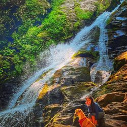
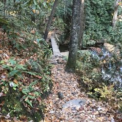
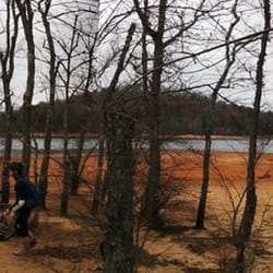
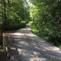
Another gorgeous summit on the Appalachian Trail. 36.4 miles from Springer Mountain (southern terminus of the AT) and 3,486 feet in elevation, it's definitely a sight to behold. This was honestly one of my favorite vistas, nothing but wilderness for miles, a steep drop down. I felt... small, as I should. The world laid out before me, no one around, silence save for the wind... let that set in. The easiest and quickest approach is from Teastnatee Gap one mile to the North. The hike up isn't easy by any means unless you're a day hiker packing a water bottle or two. The incline is steep, trail not too forgiving either but, 100% worth it. Once you reach the top, just stand and look over the wild before you, the greens of the trees, blacks and grays of the rock, blues of the sky and whites of the clouds. I could go on but, it's an experience you need to have yourself. If you're feelin adventurous and want a FULL day of pain, amazement and wonder, start your day at Neel Gap, hime the 5 miles to Cowrock and visit the Levelland Mountain and Wolf Laurel Summits in between. And, take your time, stop and appreciate the peace, sights and sounds of it all. It's absolutely gorgeous. Regardless of how you choose to get to the Cowrock Summit, I GUARANTEE it'll be worth the hike. read more


More info about Cowrock Summit
Appalachian Trl
Hiawassee, GA 30546
Directions
Hours
Outdoor Amenities


Cowrock Summit - hiking - Updated May 2026
Best of Hiawassee
People found Cowrock Summit by searching for…
Hiking Trails in Hiawassee, GA
Beautiful Views in Hiawassee, GA
Scenic Overlook in Hiawassee, GA
Lookout Points in Hiawassee, GA
Off Road Trails in Hiawassee, GA
Off Leash Dog Hikes in Hiawassee, GA
Walking Trails in Hiawassee, GA
Running Trails in Hiawassee, GA
Stroller Friendly Hikes in Hiawassee, GA
Waterfalls and Swimming Holes in Hiawassee, GA
Trending Searches in Hiawassee, GA
Baseball Fields near Cowrock Summit
Boat Rental near Cowrock Summit
Botanical Gardens near Cowrock Summit
Bounce House Rentals near Cowrock Summit
Campgrounds near Cowrock Summit
Cheap Plants near Cowrock Summit
Cliff Jumping near Cowrock Summit
Dog Friendly Trails near Cowrock Summit
Floral Designers near Cowrock Summit
Flower Shop near Cowrock Summit
Mountain Bike Trails near Cowrock Summit
Nurseries & Gardening near Cowrock Summit
Outdoor Furniture Stores near Cowrock Summit
Party Equipment Rentals near Cowrock Summit
Photo Spots near Cowrock Summit
Picnic Areas near Cowrock Summit
Places To Take Pictures near Cowrock Summit
Pool Supplies near Cowrock Summit
Rock Quarry near Cowrock Summit
Running Trails near Cowrock Summit
Scenic Drive near Cowrock Summit
Swimming Holes near Cowrock Summit
Table And Chair Rentals near Cowrock Summit
Browse Articles
Browse Nearby
Browse Brands
Related Searches in Hiawassee, GA
Affordable Kayak Rental Services in Hiawassee, Georgia
Best Fishing Locations and Guides in Hiawassee, Georgia
Best Places for Horseback Riding in Hiawassee, Georgia
Best Waterfalls and Swimming Holes in Hiawassee, Georgia
Check Out Off Road Trails in Hiawassee, Georgia
Discover Dog Friendly Trails to Explore in Hiawassee, Georgia
Discover Kid Friendly Hiking Trails in Hiawassee, Georgia
Discover Scenic Mountain Bike Trails Near Hiawassee, Georgia
Discover Top Boat Tours in Hiawassee, Georgia for All Ages
Discover a Hiking Trail in Hiawassee, Georgia
Discover the Best Running Track in Hiawassee, Georgia
Dog-Friendly Hikes With Dogs in Hiawassee, Georgia
Enjoy Camping Adventures Around Hiawassee, Georgia
Enjoy River Tubing Adventures in Hiawassee, Georgia
Enjoy Tent Camping Spots Around Hiawassee, Georgia
Enjoy the Best Tubing Experiences in Hiawassee, Georgia
Enjoy the Best Walking Trails in Hiawassee, Georgia
Exciting Cliff Jumping Spots in Hiawassee, Georgia
Explore Beautiful Parks and Green Spaces in Hiawassee, Georgia
Explore Bike Rentals Throughout Hiawassee, Georgia
Explore Easy Hikes Perfect for All in Hiawassee, Georgia
Explore Free Things to Do Around Hiawassee, Georgia
Explore Fun Activities to Do in Hiawassee, Georgia
Explore Popular Campgrounds Near Hiawassee, Georgia
Explore Popular Scenic Overlook Points in Hiawassee, Georgia
Explore Secret Spots Worth Visiting in Hiawassee, Georgia
Explore Top Water Parks in Hiawassee, Georgia Today
Explore the Best Boating Spots in Hiawassee, Georgia
Explore the Best Swimming Holes Around Hiawassee, Georgia
Family Friendly Hiking With Kids in Hiawassee, Georgia
Find Cozy Camping Cabins in Hiawassee, Georgia
Find Fun Kids Activities Outdoor in Hiawassee, Georgia
Find Popular Ziplining Spots Around Hiawassee, Georgia
Find Top Dog Swimming Spots in Hiawassee, Georgia
Find the Best Playgrounds to Visit in Hiawassee, Georgia
Find the Best Scenic View Locations in Hiawassee, Georgia
Hiking Trails With Waterfalls in Hiawassee, Georgia
Off Leash Dog Hiking Trails in Hiawassee, Georgia
Plan a Scenic Drive Route Near Hiawassee, Georgia
Popular Fishing Spots to Explore in Hiawassee, Georgia
Popular Kids Activities in Hiawassee, Georgia
Popular Picnic Spots to Visit in Hiawassee, Georgia
Safe River Swimming Areas in Hiawassee, Georgia
Safe and Fun Parks for Kids in Hiawassee, Georgia
Top Climbing Spots and Gyms in Hiawassee, Georgia
Top Paddleboarding Activities in Hiawassee, Georgia
Top Running Trails to Explore in Hiawassee, Georgia
Top Swimming Spots and Pools in Hiawassee, Georgia