Minnehaha Falls Photos


More like Minnehaha Falls
Recommended Reviews - Minnehaha Falls
Start your review...

Reviews With Photos

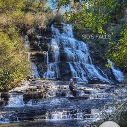
How can this beautiful creation by Mother Nature not be 5 stars? The trail head was well marked and the walk was easy to navigate and it only took about 10-15 minutes to get to the base of the falls. The waterfall is majestic and there are lots of places for amazing photos. It's mostly shady, but the sun shines through. There are trees, and shrubs all around, and we did notice some poison ivy right by the trail; so beware! While we visited there were several other hikers around, some with small children, and even dogs. It's a relatively easy hike for anyone without mobility issues. Some hikers even took off their shoes and climbed into the chilly water because they had their swimsuits on. There didn't seem to be any designated parking. Most people just parked on the shoulder of the road near the steps leading up the trail. (We were there on a gorgeous Saturday in June and there wasn't much vehicle traffic or foot traffic.) Another plus is that it is just about 90 minutes from Atlanta. The roads are mountainous, curvy, and unpaved at times, so I would suggest taking a reliable vehicle with four-wheel drive. There is no charge for entry so I definitely recommend checking it out!

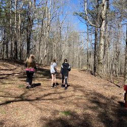
We drove passed the tiny pull off and stairs leading up and only saw it on the way back. This gem is easy to miss! Tiny, winding road- doing a 3 point u-turn was interesting, to say the least- this waterfall is tucked away! This was a relatively easy hike to the falls- short, but some spots were slippery- just be cautious. We were the only ones out there when we hiked up- and what a breathtaking view! There was a huge rock slab- almost natures bench strategically placed to gaze upon the glorious waterfall. We had visited numerous falls in the area and I picked this one as my favorite- I can only imagine what it would be like to live in one of the houses tucked away along the stream! I would be at the falls everyday. The views of Lake Rabun are stunning as well- simply gorgeous area.


Popped my seeing-a-water-fall-on-a-hike cherry this past weekend with Miss Minnehaha Falls, and I'm looking for more than a hit-it-and-quit-it type of 'ship. 'Nah mean? #allthehyphens This is my round-about way of writing that Minnehaha Falls--the beautifully imposing and multi-layered level gusher hidden in an affluent lake city up in North Georgia-- "is really, really, ridiculously good looking." -- Derek Zoolander. We parked on some dirt road, outside of a man's house who wears a coon hat and carries a sawed-off shotgun everywhere (or that's what we heard while hiking the Appalachian Trail), and the trek to the destination took, maybe, five minutes if we continuously walked. Oh, and if you can walk, you'll have no problem getting there. Climb around the rocks on the sides to ascend up a level or two, in order to take badass and dramatic pictures of mounting this sexy beast. Then brag about it on the 'gram. Like with most hiking trips, always consider bringing footwear with grip. After a really crappy and arduous week, Minnehaha Falls delivered multiple breaths, and cold splashes, of vitality. I felt alive, especially since a slip here or there could've easily caused serious harm or most likely death. Thank you, baby. You made my weekend. Call me?

So, I have a Honda Accord, and at the time it was weighed down by 4 people. I'm telling you this because a good 4 miles of the ride to Minnehaha Falls is dirt/gravel road, that under muddy/wet situations, my trusty little Honda may not have made it, but made it we did, and i'm so happy for it. Minnehaha Falls are beautiful, and while it didn't seem like this part of the state got rain, the falls were coming down nicely. The falls come down a rock surface that are shaped in a stair like fashion that you can actually climb up. I didn't climb all the way, but we saw people waaaaaaay at the top. Of course going up is much easier than coming down, since the surfaces are slippery, and in fact, one more than one of our party slipped, although no one was hurt. With that said, BE CAREFUL!! To get the trail started, there's parking, although very limited (holding maybe 6 cars) at the base of the trail, which is noted by a set of wooden rickety stairs. Pay close attention and "To Minnehaha" is written on the stair guard rail. The trail itself isn't long at all. At most it's a half a mile, though it may be slightly shorter. There's a natural opening to smaller cascades on the right of the trail, maybe 2/3 of the way. You'll want to follow this trail, hug the right side while trying to not fall into the running water. Doing this allows you to see the entirety of the falls from below! You can't (or we couldn't) continue on and had to cross back to the main trail. Minnehaha IS impressive, tall (and I love my tall falls), and I can't even imagine how heavy the waters would flow if you caught it immediately after (or during) heavy rains. If you're coming here to get a nice cardio blast and leg burn, Minnehaha isn't going to help you with its very short trail. But if you want to get out of the city, away from state park crowds, and want to go on the road less traveled to have a waterfall almost entirely by yourself, Minnehaha Falls are absolutely worth a visit! Definitely a great one!

Location: On Lake Rabun in Lakemont, GA. Favorite thing: This waterfall was a short little hike and id you're not careful you'll miss the stairway that says Minehaha on the railing. - Positives: The waterfall is climbable which was awesome, beautiful scenery with my favorite trees all along the trail. - Negatives: Dirt road may be dangerous in small cars but my boyfriend and I made it through with his 4 series, just had to take our time. - Overall: can't wait to be back and see what the summertime is like!

Because I have family in MN, when they saw I was at Minnehaha Falls, they thought I was in town. Don't get that Minnehaha confused with the one in GA. I've been to MN's Minnehaha Falls in the 90s. Over a decade ago, I went on a waterfall hiking spree and hiked as many as I could and dragged my family along. The first time I've been to Minnehaha Falls was in the mid 2000s. It was so gorgeous. I was impressed with how close we got to the waterfalls. At that time, we were the only ones there. Fast forward, a decade later, I went back with an aspiring photographer friend and I told her about Minnehaha Falls where she could capture great photos. We went during fall to see nature at its most colorfulness. Even at that time, we were the only ones there. Now almost a decade later, I am back with my hiking and foodie Yelp family. Minnehaha Falls is hard to find because it is not well marked. You will see stairways to the falls. Plus on the way there, you may think you'll be lost in the countriness mountainside of GA. When we got there, I was surprised to see a lot of cars there that were not part of the group. There is a parking lot area but was flooded with water in that area. In the past, I used to park in that area. It is a short hike. The waterfall itself is tall and beautiful. You still can go up high and get close and personal with the waterfall. There were people that went close to the top. I had on hiking shoes but they did not have good grip on the water. I need new hiking shoes with good grip! I slipped a couple of times but caught myself and did not fall lol. For a short trail with a gorgeous view of the waterfalls that you can touch, Minnehaha Falls is it. However, if you're looking for a good sweat, this is not for you. I mean it definitely is Instagram and selfie worthy. 2017 Review #32

1 month ago
Worth every step! Follow the trail, listen for the water, and let the mountains do the rest. Minnehaha Falls is the kind of beauty you have to slow down to truly see. read more


Minnehaha falls is a hidden gem! The trail is very short, about half a mile, so very doable and more than friendly for beginners. There are a lot of roots on the unpaved path but it's not a challenging trek. The part I would be most careful about is the end, as it can be slippery on the wet rocks closest to the waterfall. The waterfall itself is very large (larger than what pictures make it seem even) and nice to look at. The parking situation is very minimal - it's really just space off the side of the road for a few cars to park in. The drive there is nice, and you can see many old lake houses alongside the river. read more


What a great place to take photos of a waterfall! Probably the easiest place ever to hike to in order to take great photos of a waterfall. The previous day, my son and I went to Hemlock Falls, which is about an hour hike to see a small waterfall. We didn't know what to expect at Minnehaha. But, we saw a retired couple go up the entrance stairs and they didn't bring anything with them, not even a water bottle. So, we guessed this should be an easy hike. The hardest park is just trying to get to this place. We talked with the others at the falls and all of us had problems with GPS. We kept missing the turn into the gravel road (Bear Gap road) that leads to the falls, probably the phone cell reception was bad at that location. There are very few parking spaces available at the "entrance", enough space for less than 6 cars. But, the good thing is you don't have to pay for a parking pass. Must stop visit if you're in the area and want a very easy walk to a spectacular view of waterfalls. read more


How can this beautiful creation by Mother Nature not be 5 stars? The trail head was well marked and the walk was easy to navigate and it only took about 10-15 minutes to get to the base of the falls. The waterfall is majestic and there are lots of places for amazing photos. It's mostly shady, but the sun shines through. There are trees, and shrubs all around, and we did notice some poison ivy right by the trail; so beware! While we visited there were several other hikers around, some with small children, and even dogs. It's a relatively easy hike for anyone without mobility issues. Some hikers even took off their shoes and climbed into the chilly water because they had their swimsuits on. There didn't seem to be any designated parking. Most people just parked on the shoulder of the road near the steps leading up the trail. (We were there on a gorgeous Saturday in June and there wasn't much vehicle traffic or foot traffic.) Another plus is that it is just about 90 minutes from Atlanta. The roads are mountainous, curvy, and unpaved at times, so I would suggest taking a reliable vehicle with four-wheel drive. There is no charge for entry so I definitely recommend checking it out! read more


6 years ago
We drove passed the tiny pull off and stairs leading up and only saw it on the way back. This gem is easy to miss! Tiny, winding road- doing a 3 point u-turn was interesting, to say the least- this waterfall is tucked away! This was a relatively easy hike to the falls- short, but some spots were slippery- just be cautious. We were the only ones out there when we hiked up- and what a breathtaking view! There was a huge rock slab- almost natures bench strategically placed to gaze upon the glorious waterfall. We had visited numerous falls in the area and I picked this one as my favorite- I can only imagine what it would be like to live in one of the houses tucked away along the stream! I would be at the falls everyday. The views of Lake Rabun are stunning as well- simply gorgeous area. read more


6 years ago
Crazy Drive, short hike great for the dogs but lots of roots so you have be be careful. VERY limited parking. Would have loved to stay and sit awhile. While the trail was not crowded, we were not alone and had to take turns taking pictures. Great stop #VickieTravelz read more


3 years ago
Easy hike to this beautiful waterfall! One of the most peaceful places! Tiny lavender butterflies everywhere! Just a dreamy place! Limited parking, go early! Right off the road. read more

7 years ago
LOVED IT!!! Great day trip and easy to hike! Hard to find. If you don't look you might pass the set of stairs to get to it. Slippery but very beautiful read more


7 years ago
Easy walk, beautiful falls. When I say easy, you still need to watch your footing and it can get wet but my 85 year old grandma does it with us. We obviously go slow. Overall short and sweet. Dog friendly. Parking is just stopping along the road so that's not the best. read more


7 years ago
5 years ago
The falls are so beautiful and the climb is pretty easy. The drive on the narrow, dirt road was an adventure. I am glad we did it however I wasn't prepared for the access read more

3 years ago
9 years ago
Popped my seeing-a-water-fall-on-a-hike cherry this past weekend with Miss Minnehaha Falls, and I'm looking for more than a hit-it-and-quit-it type of 'ship. 'Nah mean? #allthehyphens This is my round-about way of writing that Minnehaha Falls--the beautifully imposing and multi-layered level gusher hidden in an affluent lake city up in North Georgia-- "is really, really, ridiculously good looking." -- Derek Zoolander. We parked on some dirt road, outside of a man's house who wears a coon hat and carries a sawed-off shotgun everywhere (or that's what we heard while hiking the Appalachian Trail), and the trek to the destination took, maybe, five minutes if we continuously walked. Oh, and if you can walk, you'll have no problem getting there. Climb around the rocks on the sides to ascend up a level or two, in order to take badass and dramatic pictures of mounting this sexy beast. Then brag about it on the 'gram. Like with most hiking trips, always consider bringing footwear with grip. After a really crappy and arduous week, Minnehaha Falls delivered multiple breaths, and cold splashes, of vitality. I felt alive, especially since a slip here or there could've easily caused serious harm or most likely death. Thank you, baby. You made my weekend. Call me? read more


9 years ago
So, I have a Honda Accord, and at the time it was weighed down by 4 people. I'm telling you this because a good 4 miles of the ride to Minnehaha Falls is dirt/gravel road, that under muddy/wet situations, my trusty little Honda may not have made it, but made it we did, and i'm so happy for it. Minnehaha Falls are beautiful, and while it didn't seem like this part of the state got rain, the falls were coming down nicely. The falls come down a rock surface that are shaped in a stair like fashion that you can actually climb up. I didn't climb all the way, but we saw people waaaaaaay at the top. Of course going up is much easier than coming down, since the surfaces are slippery, and in fact, one more than one of our party slipped, although no one was hurt. With that said, BE CAREFUL!! To get the trail started, there's parking, although very limited (holding maybe 6 cars) at the base of the trail, which is noted by a set of wooden rickety stairs. Pay close attention and "To Minnehaha" is written on the stair guard rail. The trail itself isn't long at all. At most it's a half a mile, though it may be slightly shorter. There's a natural opening to smaller cascades on the right of the trail, maybe 2/3 of the way. You'll want to follow this trail, hug the right side while trying to not fall into the running water. Doing this allows you to see the entirety of the falls from below! You can't (or we couldn't) continue on and had to cross back to the main trail. Minnehaha IS impressive, tall (and I love my tall falls), and I can't even imagine how heavy the waters would flow if you caught it immediately after (or during) heavy rains. If you're coming here to get a nice cardio blast and leg burn, Minnehaha isn't going to help you with its very short trail. But if you want to get out of the city, away from state park crowds, and want to go on the road less traveled to have a waterfall almost entirely by yourself, Minnehaha Falls are absolutely worth a visit! Definitely a great one! read more


 - Parks Near Me - Tallulah Falls, Georgia")


Location: On Lake Rabun in Lakemont, GA. Favorite thing: This waterfall was a short little hike and id you're not careful you'll miss the stairway that says Minehaha on the railing. - Positives: The waterfall is climbable which was awesome, beautiful scenery with my favorite trees all along the trail. - Negatives: Dirt road may be dangerous in small cars but my boyfriend and I made it through with his 4 series, just had to take our time. - Overall: can't wait to be back and see what the summertime is like! read more


Because I have family in MN, when they saw I was at Minnehaha Falls, they thought I was in town. Don't get that Minnehaha confused with the one in GA. I've been to MN's Minnehaha Falls in the 90s. Over a decade ago, I went on a waterfall hiking spree and hiked as many as I could and dragged my family along. The first time I've been to Minnehaha Falls was in the mid 2000s. It was so gorgeous. I was impressed with how close we got to the waterfalls. At that time, we were the only ones there. Fast forward, a decade later, I went back with an aspiring photographer friend and I told her about Minnehaha Falls where she could capture great photos. We went during fall to see nature at its most colorfulness. Even at that time, we were the only ones there. Now almost a decade later, I am back with my hiking and foodie Yelp family. Minnehaha Falls is hard to find because it is not well marked. You will see stairways to the falls. Plus on the way there, you may think you'll be lost in the countriness mountainside of GA. When we got there, I was surprised to see a lot of cars there that were not part of the group. There is a parking lot area but was flooded with water in that area. In the past, I used to park in that area. It is a short hike. The waterfall itself is tall and beautiful. You still can go up high and get close and personal with the waterfall. There were people that went close to the top. I had on hiking shoes but they did not have good grip on the water. I need new hiking shoes with good grip! I slipped a couple of times but caught myself and did not fall lol. For a short trail with a gorgeous view of the waterfalls that you can touch, Minnehaha Falls is it. However, if you're looking for a good sweat, this is not for you. I mean it definitely is Instagram and selfie worthy. 2017 Review #32 read more


5 years ago
6 years ago
10 years ago
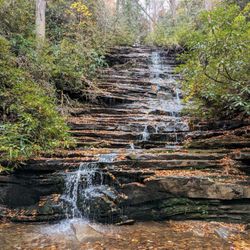
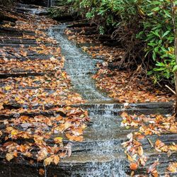
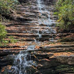
Several websites boast of Minnehaha Falls being the best waterfall in all of Rabun County. I would present Panther Creek Falls and Dicks Creek Falls as strong arguments against that claim. Nevertheless, it is indeed a fantastic natural beauty. Sources claim the overall height to be anywhere from 60 to 100 feet high. I'd say 75' is about accurate for the upper falls. ----- THE EXPERIENCE I begin my hike at a small parking area with no directional signage whatsoever! Clearly the US Forest Services have this place as low on their priority list and it could possibly get. It would have been comforting to know I was in the right spot and not walking up to someone's home. Now, you might think to yourself that should be an easy mistake NOT to make, right? But if you ever visit and see the homes along this stretch of mountain road, you'll understand why it can be confusing. On the opposite side of the road from the parking area are a rickety set of wooden and earthen stairs. I've included a picture of both the parking area and steps to help you be less confused than I was along your journey to these falls: https://www.yelp.com/biz_photos/minnehaha-falls-tallulah-falls?select=zSUiiV3XgWPyssxAP9YucA The trail is fairly short. Trail guides say it is less than half a mile, but I would venture to say it's even shorter than that (around a quarter of a mile). I got to the falls REALLY quick! Along the way you will see a small trail that spurs off to the right leading to the riverbed. Follow it! Although you might think these cascades are indeed the falls, they are not. Just a tiny version of the main waterfall, where the water crosses over black shale rock ledges. At about 120 feet in overall height, it is spectacular in its own right. After a few pics of the "baby falls" I rejoined the trail and continued upstream. As I climbed a small hill littered with tree roots, the main falls came into view. What a majestic view it was! Remember the scene from Jurassic Park when the doctor finally laid eyes on a field of dinosaur for the first time. Well, it felt like that! I didn't expect the waterfall to be so tall and feel so enclosed. This area of the forest is a well-seclude cavity in the mountain, which makes standing at the base of the falls feel kinda like being inside an enormous stone bowl. A flat boulder at the shoreline (about 15 feet in length) makes for a comfy spot to sit and enjoy the falls. It also appears to be a great water diverted when the flow of the falls is higher. The entire base of the falls is one giant stone outcrop. Very smooth and very slick, so watch your step. Rhododendron plants drape the mountainsides like curtains, so I can only imagine the beauty of this place when they are in bloom in the early Spring. ----- FINAL THOUGHTS During my visit today I ran into several sets of elderly couples (two of which had walking canes) and also a group of 3 senior ladies out exploring. I say that to say this hike is easy, probably the easiest hike you may ever experience to a hidden mountain waterfall. The only hike I know easier than this is nearby Toccoa Falls and Dicks Creek Falls. The hardest part of your visit here will undoubtedly be the treacherous drive down Bear Gap Road. Once the road changes from paved to gravel, there are many blind hair-pin turns, narrow passages, and deadly steep roadside embankments that will have you praying HARD that no cars will be driving from the opposite direction for you to pass. I am not faint of heart and yet I was freaking out along this 4 mile stretch of gravel road, particularly when I came face to face with a giant concrete truck. The Good Lord must have seriously gotten tired of me calling his name! PLEASE drive carefully and enjoy. - Best after a heavy rainfall or in the Spring when upper elevation snow is melting - Slippery surfaces near falls. Be cautious of wet stones. **Recommended for families with small children **Recommended for able bodied seniors 2016/115 read more


6 years ago
7 years ago
9 years ago
10 years ago
More info about Minnehaha Falls
Ask the Community - Minnehaha Falls
Review Highlights - Minnehaha Falls


Why does Yelp recommend reviews?
1 review that is not currently recommended
The reviews below are not factored into the business's overall star rating.
18 years ago
Minnehaha Falls - parks - Updated May 2026
Best of Tallulah Falls
People found Minnehaha Falls by searching for…
Hiking Trails With Waterfalls in Tallulah Falls, GA
Things to Do in Tallulah Falls, GA
Water Parks in Tallulah Falls, GA
Fireworks in Tallulah Falls, GA
Places to Take Pictures in Tallulah Falls, GA
Cliff Jumping in Tallulah Falls, GA
Playgrounds in Tallulah Falls, GA
Scenic Overlook in Tallulah Falls, GA
Watch Sunset in Tallulah Falls, GA
Star Gazing in Tallulah Falls, GA
River Swimming in Tallulah Falls, GA
Off Road Trails in Tallulah Falls, GA
Scenic Views in Tallulah Falls, GA
Waterfalls and Swimming Holes in Tallulah Falls, GA
Secluded Spots in Tallulah Falls, GA
Beautiful Views in Tallulah Falls, GA
Walking Trails in Tallulah Falls, GA
Waterfalls in Tallulah Falls, GA
Photo Spots in Tallulah Falls, GA
Fun Things to Do at Night in Tallulah Falls, GA
Trending Searches in Tallulah Falls, GA
Baseball Fields near Minnehaha Falls
Botanical Gardens near Minnehaha Falls
Campgrounds near Minnehaha Falls
Cliff Jumping near Minnehaha Falls
Fishing Spots near Minnehaha Falls
Nurseries & Gardening near Minnehaha Falls
Outdoor Furniture Stores near Minnehaha Falls
Party Equipment Rentals near Minnehaha Falls
Pick Your Own Farms near Minnehaha Falls
Picnic Areas near Minnehaha Falls
Places To Take Pictures near Minnehaha Falls
Rock Quarry near Minnehaha Falls
Rv Rental near Minnehaha Falls
Swimming Holes near Minnehaha Falls
Browse Articles
Browse Nearby
Browse Brands
Related Searches in Tallulah Falls, GA
Best Fishing Locations and Guides in Tallulah Falls, Georgia
Best Fun Things to Do in Tallulah Falls, Georgia
Best Parks for Parties and Events in Tallulah Falls, Georgia
Best Water Parks for Kids in Tallulah Falls, Georgia
Best Waterfalls and Swimming Holes in Tallulah Falls, Georgia
Check Out Great Playgrounds in Tallulah Falls, Georgia
Check Out Off Road Trails in Tallulah Falls, Georgia
Discover Baseball Fields Around Tallulah Falls, Georgia
Discover Popular Photo Spots in Tallulah Falls, Georgia
Discover Soccer Fields in Tallulah Falls, Georgia Near You
Discover the Best Beaches in Tallulah Falls, Georgia
Enjoy Tent Camping Spots Around Tallulah Falls, Georgia
Enjoy the Best Picnic Spots and Ideas in Tallulah Falls, Georgia
Experience Stunning Sunset Views in Tallulah Falls, Georgia
Explore Easy Hikes Perfect for All in Tallulah Falls, Georgia
Explore Family-Friendly Zoos and Wildlife in Tallulah Falls, Georgia
Explore Free Picnic Areas Around Tallulah Falls, Georgia
Explore Free Things to Do Around Tallulah Falls, Georgia
Explore Landmarks & Historical Buildings in Tallulah Falls, Georgia
Explore Parks With Pull Up Bars in Tallulah Falls, Georgia
Explore Popular Campgrounds Near Tallulah Falls, Georgia
Explore Popular Picnic Areas Around Tallulah Falls, Georgia
Explore Popular RV Parks Around Tallulah Falls, Georgia
Explore Popular Recreation Centers Around Tallulah Falls, Georgia
Explore Popular Scenic Views Near Tallulah Falls, Georgia
Explore Scenic Lakes to Visit in Tallulah Falls, Georgia
Explore Summer Camps for All Ages in Tallulah Falls, Georgia
Explore Top Dog Parks in Tallulah Falls, Georgia Near You
Explore the Best Swimming Holes Around Tallulah Falls, Georgia
Find Top Skating Rinks in Tallulah Falls, Georgia for All Ages
Find Top-Rated Disc Golf in Tallulah Falls, Georgia
Find Top-Rated Waterfalls in Tallulah Falls, Georgia Now
Find the Best Parks BBQ Grills in Tallulah Falls, Georgia
Find the Best Parks for Picnics in Tallulah Falls, Georgia
Find the Best Swimming Pools in Tallulah Falls, Georgia Today
Great Places to Swim in Tallulah Falls, Georgia
Have Fun at a Splash Pad in Tallulah Falls, Georgia
Hiking Trails With Waterfalls in Tallulah Falls, Georgia
Perfect Spots to Watch Sunset in Tallulah Falls, Georgia
Picnic Areas With BBQ Pits Available in Tallulah Falls, Georgia
Popular Fishing Spots to Explore in Tallulah Falls, Georgia
Popular Kids Activities in Tallulah Falls, Georgia
Popular Places to Take Pictures in Tallulah Falls, Georgia
Popular Things to Do in Tallulah Falls, Georgia
Relax at Natural Hot Springs Near Tallulah Falls, Georgia
Safe River Swimming Areas in Tallulah Falls, Georgia
Top Things to Do With Kids in Tallulah Falls, Georgia
Top-Rated Basketball Courts to Play at in Tallulah Falls, Georgia
People who viewed Minnehaha Falls also viewed
Mount Yonah Trailhead
37 reviews
High Shoals Falls Loop Trail
17 reviews
Dicks Creek Falls
12 reviews
Woody Gap Recreation Area
11 reviews
Yahoola Creek Park
10 reviews
Panther Creek Recreation Area
37 reviews
Cowrock Summit
1 review
Lookout Rock
1 review
Lake Chatuge
9 reviews
Soquee River Falls - Grandpa Watts Mill
1 review