Dicks Creek Falls Photos


More like Dicks Creek Falls
Recommended Reviews - Dicks Creek Falls
Start your review...

Reviews With Photos

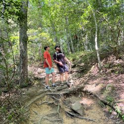
Waterfalls and swimming? I'm down. This is coming from someone who cannot swim but still love some waterfalls. Not much hiking required but I was coming with my brother and his family too. They wanted to swim and my nephew is young. I couldn't believe my SIL and her daughter have never seen a waterfall in their life! I had to take them there. They see my waterfall pics all the time on Instagram and Facebook, so they wanted to tag along. I've heard great things about Dicks Creek Falls. Richard R has told me before that he list it as his top 5 favorite waterfalls in Georgia! You will follow 129 N and make a turn onto Dicks Creek Road, which will take you to the back of neighborhoods. The road is narrow but paved. Once you get closer to the parking area, it will be gravel. There is not much hiking done but you will have to walk down to the creek to see the waterfalls. There are different sections. We arrived early, around 8 am. We already saw people there. They were already picnicking. We decided to go to the section where the pretty waterfalls were. We saw guys fishing in the area near the waterfalls. I was like fish here like that? We saw a few. The water is clear. It is VERY slippery AND cold!! I got in the water and wanted to enjoy the beautiful view. My SIL came closer to us, slipped and fell! The waterfall is so beautiful though. Once the fishermen moved out the way, we decided to go closer to the waterfalls. My daughter is able to swim and got in the water and said she's not able to touch the ground. There is a swimming hole right in front of the waterfalls!! That's where they were fishing! Hubby went closer to the swimming hole and slipped!!! I'm glad I didn't go that closely. It's so slippery, he tried to be careful but it is deep like that! He was just testing it out. Luckily, he is able to swim. Same thing happened to my brother. He slipped and fell in a different area too! They swam across. I was not going near that area. I cannot swim! We saw people on top of the waterfalls taking selfies and stuff. They gotta be careful. We did read about a father and son who died at Dick's Creek over the summer. We walked and walked towards farther south and there were some areas where it was hard to get any farther but we saw more fishermen and decided to stop. The waterfall where the swimming hole is the prettiest! More and more people started to come. We decided to leave after 2 hours there. Definitely worth the trip there. Swimming access but be careful! Very slippery. Pretty waterfall. 120/2017


This was definitely a different landscape for us and we loved it. We were happy we had a four wheel drive because the drive here is not paved at has steep hills. When you get here there is no signage at all. You just drive and look for it. There is really no parking except for parking on the side of the creek. There are areas for people to camp but they are not defined. We drove as high as we could and someone else driving down. They told us to follow them to one of the falls, but there was not much of a fall bc of the lack of rain. We had also parked at the spot they pointed to us for a break from the uphill steep drive. We went down more and parked by the creek and went down to see the water. When we got there, we looked up and saw the fall, but it was a bit of a distance for us to drive back to, plus we would have to walk over rocks to get to it. I didn't get to take a pic but it was pretty. We did like this trip, but I think I wished I could have seen more. The day before we went to the Edge of the World in Dahlonega and enjoyed that more. read more
4 years ago
Place was beautiful, but it kinda sucked that the upper falls are closed due to some construction to the trails. It really doesn't tell you anywhere either, you just find out when you get there. Place is so amazing though! read more


Waterfalls and swimming? I'm down. This is coming from someone who cannot swim but still love some waterfalls. Not much hiking required but I was coming with my brother and his family too. They wanted to swim and my nephew is young. I couldn't believe my SIL and her daughter have never seen a waterfall in their life! I had to take them there. They see my waterfall pics all the time on Instagram and Facebook, so they wanted to tag along. I've heard great things about Dicks Creek Falls. Richard R has told me before that he list it as his top 5 favorite waterfalls in Georgia! You will follow 129 N and make a turn onto Dicks Creek Road, which will take you to the back of neighborhoods. The road is narrow but paved. Once you get closer to the parking area, it will be gravel. There is not much hiking done but you will have to walk down to the creek to see the waterfalls. There are different sections. We arrived early, around 8 am. We already saw people there. They were already picnicking. We decided to go to the section where the pretty waterfalls were. We saw guys fishing in the area near the waterfalls. I was like fish here like that? We saw a few. The water is clear. It is VERY slippery AND cold!! I got in the water and wanted to enjoy the beautiful view. My SIL came closer to us, slipped and fell! The waterfall is so beautiful though. Once the fishermen moved out the way, we decided to go closer to the waterfalls. My daughter is able to swim and got in the water and said she's not able to touch the ground. There is a swimming hole right in front of the waterfalls!! That's where they were fishing! Hubby went closer to the swimming hole and slipped!!! I'm glad I didn't go that closely. It's so slippery, he tried to be careful but it is deep like that! He was just testing it out. Luckily, he is able to swim. Same thing happened to my brother. He slipped and fell in a different area too! They swam across. I was not going near that area. I cannot swim! We saw people on top of the waterfalls taking selfies and stuff. They gotta be careful. We did read about a father and son who died at Dick's Creek over the summer. We walked and walked towards farther south and there were some areas where it was hard to get any farther but we saw more fishermen and decided to stop. The waterfall where the swimming hole is the prettiest! More and more people started to come. We decided to leave after 2 hours there. Definitely worth the trip there. Swimming access but be careful! Very slippery. Pretty waterfall. 120/2017 read more


4 years ago
3 years ago
5 years ago
8 years ago
I live two hours away, but I'll be back. This was a beautiful spot & would be fantastic for bringing kids to swim on a hot, summer day. read more

4 years ago
10 years ago
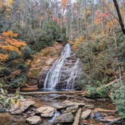
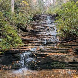
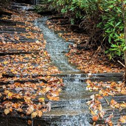
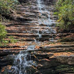
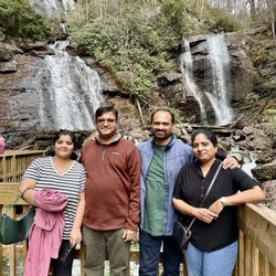
There seems to be some confusion over whether or not these falls are called Dicks Creek Falls or Waters Creek falls since the two streams merge near the waterfall. My vote goes to Dicks Creek because the falls themselves are AFTER the merge along what is known as Dicks Creek. Whatever you want to call them, I'm certain the beauty of the falls will surprise you. I've toured many waterfalls in the North Georgia area and have racked up a list that includes: Anna Ruby, Duke's Creek, Amicalola, Raven Cliff, Panther Creek, Toccoa, Minnehaha, all the falls @ Tallulah Gorge, and both the falls located within Smithgall Woods. Only Panther Creek, Tallulah and Toccoa have solid granite-like surfaces and not the black shale surfaces of the others. So I was surprised to find this one not only to be granite, but maybe the most granite-like surface of them all with a huge outcropping all around the falls. ----- THE EXPERIENCE There is almost no hiking required. The falls are broken up into two sections. The upper falls are visible from the road while the larger lower fall (approximately 18 feet in height) require traversing a short trail leading to the huge granite slab base. My visit was during a severe drought here in Georgia and still the water flow was excellent. I can't even begin to imagine how thunderous the falls would be in times of normal or heavy flow. From the road a long finger-like granite outcrop will lead you to the best photo area of the upper falls. Continue along the granite as it descends to a small pool area above the main falls. Off to your left will be a root laced trail leading around a ginormous boulder. From the top of the boulder you can get a great aerial view of the larger falls, or continue down the trail to the base of the falls. The pool of crystal clear water at the base looked to be about 6 or 8 feet deep in some areas. The shiny stones at the creek floor would fool you into believing they were gold nuggets. Dicks Creek is loaded with cascades and smaller waterfalls, so if you are feeling adventurous I would recommend hiking downstream. Several other photo opportunities await within 100 yards. The parking area is just above the upper falls and signs are very specific to park ONLY in the designated area. Honestly, the road is too narrow to try and park anywhere else! ----- FINAL THOUGHTS Although this may be one of the furthest waterfalls from Atlanta, it is definitely worth the drive. I would imagine making a day of it with fun family picnics while playing in the fresh waters. I didn't see any 'no swimming' signs, so I assume it would be allowed. The main road leading to the falls is US Hwy 19. Lots of historic markers along the way made me want to stop and read each one, but I was on a mission and had a limited amount of time. The area is rich in Civil War history as well as Cherokee Indian history. You could spend an entire weekend driving to all of the historical sites around the area. Once you turn onto Dicks Creek road from Hwy 19, there is a camp called Falling Waters. What you may miss is the large waterfall that is just to the rift of the sign (off in the woods). There is also a historic home with an old condemned bridge as a driveway. Look for the history marker just before the bridge (which by the way is private property, so do not cross). The monument reads: "Nearly a century ago, Wheeler W. Dunn (1885-1960) and other brave pioneers of Georgia worked these beautiful Appalachian Mountains. These pathfinders labored long hard days,from sun up to sun down, through all seasons - in all conditions (there were no labor boards or paid vacations!) These were real men. Our ancestors' toil and sweat built this country paving "our" way for a better future. The original bridge which carried those proud men to work has been restored and is now being dedicated by Lowell S. Dunn to all the Dunn family past, present and future. September 15th, 1996." Nice monument wording. Ironically slaves did the same thing, except never got to claim any land or wages for their vacation-less labor. Needless to say by the condition of the bridge, it has not been maintained over the past 20 years since its restoration. 2016/116 read more


More info about Dicks Creek Falls
Dicks Creek Rd
Cleveland, GA 30528
Directions
Hours
Outdoor Amenities
Dicks Creek Falls Reviews in Other Languages
Ask the Community - Dicks Creek Falls
Review Highlights - Dicks Creek Falls


Why does Yelp recommend reviews?
1 review that is not currently recommended
The reviews below are not factored into the business's overall star rating.
4 years ago
Dicks Creek Falls - hiking - Updated July 2026
Best of Cleveland
People found Dicks Creek Falls by searching for…
Hiking Trails With Waterfalls in Cleveland, GA
Swimming Holes in Cleveland, GA
Off Road Trails in Cleveland, GA
Places to Take Pictures in Cleveland, GA
River Swimming in Cleveland, GA
Scenic Overlook in Cleveland, GA
Beautiful Views in Cleveland, GA
Fishing Spots in Cleveland, GA
Walking Trails in Cleveland, GA
Running Trails in Cleveland, GA
Trending Searches in Cleveland, GA
Blueberry Picking near Dicks Creek Falls
Boating near Dicks Creek Falls
Cliff Jumping near Dicks Creek Falls
Cruising Spots near Dicks Creek Falls
Day Trips near Dicks Creek Falls
Jet Skis near Dicks Creek Falls
Kayak Rental near Dicks Creek Falls
Kids Activities Indoor near Dicks Creek Falls
Lookout Points near Dicks Creek Falls
Off Road Trails near Dicks Creek Falls
Outdoor Activities near Dicks Creek Falls
Peach Picking near Dicks Creek Falls
Public Shower near Dicks Creek Falls
River Swimming near Dicks Creek Falls
Rock Quarry near Dicks Creek Falls
Scenic Drive near Dicks Creek Falls
Sunrise View near Dicks Creek Falls
Surf Shop near Dicks Creek Falls
Swimming Holes near Dicks Creek Falls
Things To Do On A Rainy Day near Dicks Creek Falls
U Pick Farms near Dicks Creek Falls
Watch Sunset near Dicks Creek Falls
Browse Articles
Browse Brands
Related Searches in Cleveland, GA
Affordable Kayak Rental Services in Cleveland, Georgia
Best Dog Hiking Trails Around Cleveland, Georgia
Best Fishing Locations and Guides in Cleveland, Georgia
Best Off Leash Dog Parks in Cleveland, Georgia
Best Places for Horseback Riding in Cleveland, Georgia
Best Waterfalls and Swimming Holes in Cleveland, Georgia
Check Out Off Road Trails in Cleveland, Georgia
Discover Dog Friendly Trails to Explore in Cleveland, Georgia
Discover Easy Hiking Trails Near Cleveland, Georgia
Discover Kid Friendly Hiking Trails in Cleveland, Georgia
Discover Popular Bike Trails in Cleveland, Georgia
Discover Scenic Mountain Bike Trails Near Cleveland, Georgia
Discover a Hiking Trail in Cleveland, Georgia
Discover the Best Night Hike Trails in Cleveland, Georgia
Dog-Friendly Hikes With Dogs in Cleveland, Georgia
Enjoy Camping Adventures Around Cleveland, Georgia
Enjoy Exciting Mountain Biking Adventures in Cleveland, Georgia
Enjoy Kayaking Adventures in Cleveland, Georgia
Enjoy Off Leash Dog Hikes in Cleveland, Georgia
Enjoy River Tubing Adventures in Cleveland, Georgia
Enjoy Tent Camping Spots Around Cleveland, Georgia
Enjoy a Beautiful Waterfall Hike in Cleveland, Georgia
Enjoy the Best Picnic Spots and Ideas in Cleveland, Georgia
Enjoy the Best Walking Trails in Cleveland, Georgia
Experience Thrilling White Water Rafting in Cleveland, Georgia
Explore Beautiful Parks and Green Spaces in Cleveland, Georgia
Explore Easy Hikes Perfect for All in Cleveland, Georgia
Explore Fun Activities to Do in Cleveland, Georgia
Explore Popular Campgrounds Near Cleveland, Georgia
Explore Top Dog Parks in Cleveland, Georgia Near You
Explore Top Water Parks in Cleveland, Georgia Today
Explore the Best Swimming Holes Around Cleveland, Georgia
Family Friendly Hiking With Kids in Cleveland, Georgia
Find Cozy Camping Cabins in Cleveland, Georgia
Find Popular Ziplining Spots Around Cleveland, Georgia
Find the Best Parks for Picnics in Cleveland, Georgia
Hiking Trails With Waterfalls in Cleveland, Georgia
Off Leash Dog Hiking Trails in Cleveland, Georgia
Popular Outdoor Activities to Try in Cleveland, Georgia
Popular Picnic Spots to Visit in Cleveland, Georgia
Safe River Swimming Areas in Cleveland, Georgia
Safe and Fun Parks for Kids in Cleveland, Georgia
Top Hiking Trails to Explore in Cleveland, Georgia
Top Paddleboarding Activities in Cleveland, Georgia
Top Running Trails to Explore in Cleveland, Georgia
Top Swimming Spots and Pools in Cleveland, Georgia


