DeSoto Falls Photos


More like DeSoto Falls
Recommended Reviews - DeSoto Falls
Start your review...

Reviews With Photos

I came here to do a short hike and see some beautiful scenery. The parking area was large and there is an honor system parking fee of $3. There are public restrooms at the location but warned that there no running water! I believe the waste goes into some underground hole. So it's pretty gross. Lol The trail leads off with signs and crosses a creek on a bridge. There are 2 separate waterfalls. One is a 3/4 mile hike one way and the other is a 1/4 mile but is partly a uphill hike which will take a lot out of you. Both waterfalls are very pretty. I definitely recommend this hike if you want a decent distance hike. I believe I accumulated approximately like 6,000-6,500 steps on both waterfalls.


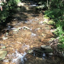
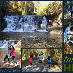
Desoto Falls are TWO separate waterfalls in one hike! Here's what you need to know. After parking and paying your fee, you will travel down a gravel path to a bridge that crosses Frogtown Creek. There are camper sites available here and along the creek people have stacked smooth stones into several cool towers. Once on the other side of the bridge you have the option to go left or right. Left leads you to the "lower falls" while right leads you to the larger "upper falls". The term "lower falls" is a bit of a misnomer, because the climb to it seemed a lot more strenuous than the upper falls. LOWER FALLS The trail to the lower says it is approximately 1/2 mile, while the upper falls trail is said to be 3/4 of a mile. Both seem about 1/4 mile longer than stated, but that's just how it feels. I didn't actually track it to see if it were true. The trail to the lower fall starts off flat, but then ascends very rapidly with the use of switchbacks. You will follow the same trail back to it's starting point near the bridge. The lower fall was surprisingly larger than I expected, but I'm not for certain how these falls are connected to the other since they don't appear to share the same stream source. The lower falls are not as photogenic and are partially blocked by vegetation. There was no reasonably danger-free way to get a better vantage, so don't risk going off trail. UPPER FALLS The trail to the upper falls keeps you snuggly next to the creek for 1/3rd of it, occasionally opening up to good photo opportunities of the creek. The trail will begin to rise on the last half as you near the falls. You will pass over two foot bridges. After the second bridge the trail appears to keep straight, but the larger upper falls will actually be to your left. You'll then hike a slight incline to a viewing platform with unobstructed views of the falls. FINAL THOUGHTS Wikipedia says there is an upper falls (200 feet tall), a middle falls (90 feet tall) and a lower falls (35 feet tall) giving the falls a grand total of 492 including the steep cascades in between falls. However, I only counted two falls and both were larger than 35 feet. I'm also curious as to how these falls are not considered two distinctly named falls since a) they are over a mile apart and b) are not fed by the same water source. Whatever the reason, it is still a very nice leisurely walk through through the woods. Perfect for beginners, but I would skip the lower falls if anyone in your group has bad knees or other physical ailments. 2017/129

DeSoto Falls is off Gainesville Highway in Dahlonega. It has a parking lot with $3/car fee and is an honor system so please pick up the envelope, pay, and deposit. Parking lot is well marked. There are signs and map of North Georgia to show where you are. Public bathroom is also available. There are signs leading you to where you are able to hike DeSoto Falls. You will pass a creek with people camping. Once you see the sign leading you to the waterfalls, you will notice there are TWO waterfalls! Yes!! There is an upper and lower waterfall. Because the Lower falls is 1/4 mile vs 3/4 mile, we decided to do the shorter one first. While hiking, we noticed a shift elevation upwards. We thought we were heading to the Lower falls, not Upper! The hike is short and not strenuous but be ready to go up! Once you get there, you will see the beautiful falls. You can sit and relax and enjoy on the bench too. Now it's time for Upper Falls. The path is much more flatter than Lower Falls. I am glad we did this last. When you finally get there, you will see the beauty. There were many signs warning to not go close to the waterfalls cause of deaths. Not only that, we did see a cross on the side of the waterfall which steered us away from even attempting. Highly recommended! Worth a trip! Short hike to two waterfalls! 64/2017

Friends of mine always ask me about accessible water fall hikes that don't take miles to get to. Welcome: Desoto Falls! With Desoto, you get a water falls BOGO, because there are two falls, upper and lower falls, both of which are fairly short in terms of distance. Lower desoto falls is 0.25 miles or a half mile round trip, and there are a few switch backs and uphill hiking, but again, at a quarter mile, it's definitely manageable by most. A nice viewing area with a nice smaller fall greets you at the end, but double back and keep going to the upper falls! Upper Desoto falls is about 0.75 miles, or 1.5 miles in and out. It cuts past campgrounds, through woods and there are a few hills that will get your heart rate elevated, but nothing you can't handle. At the end you have a really nice waterfall that is very photogenic and with a really nice viewing platform. The trail is nicely marked (look for the green marks on the trees), dog friendly, and because of the trail access, there's always a decent amount of people on the trail. Parking is based on the honor system (i.e. there is no gate keeper) but take an envelope, and please put at least a couple bucks in there before hanging the tag on your rear view mirror. Parking isn't much of a problem, and restrooms are at the lot, so if you gotta go, go! Fun, quick and accessible to all park. Worth a visit!

If you are looking for an easy hike without sacrificing views, then this is your place! There is a $3 parking fee, so don't forget to bring cash! All you have to do is place your money in the envelop and drop it in the deposit box at the entrance. There is a "bathroom" at the entrance. I say that because essentially it is a hole in the ground with a toilet on top of it, but hey it gets the job done! There are two water falls on this hike. It only took me two hours to do both, so you will not be here all day. One of the trails is shorter than the other, but both are easy hikes and very scenic. The paths are clear and easy to walk on. When I went in the early AM, there were not many people there, but as I was leaving in the afternoon, more people were arriving, but it was by no means crowded.

My teenagers and myself made the drive down after walking up Brasstown Bald today! It was recommended to us by the sweet ladies in their gift shop. We hiked up to the big falls and had planned to do the little one as well but it started raining just as we got back down. It's a well maintained trail with some level plains, inclines and declines. I'm anything but an experienced hiker (lol), far from it, and I made it so you can too. Take your time and just enjoy the walk! It's heavy on the canopy of trees over head so it wasn't in the direct sun but on our trip it was very humid so take some bottled water. There is a restroom before heading up... beware, it's more of a permanent port-a-potty. Enough said about that. Take some cash for the honor box for parking. It's only $3. Definitely worth it.

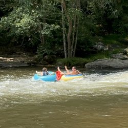
If there wasn't a recent rain or snow, the falls are not really falling. Even with the little water fall I was there for, it was still memorable. Plenty of parking. BUT, not free and definitely not easy. No cell phone signal to download app that is required to pay the $5 fee. Driving in can be stressful, as there are motorcycles zooming all around you on the winding roads. Also the loud motorcycles take away from the sound ambiance at times. There are toilets, but they are literally holes in the ground with no lighting, so just be mentally prepared for that. There is a north waterfall and a south waterfall. The north is not only larger, but an easier climb. South waterfall is tiny and basically switchback stairs. The best activity here would be camping in either tent or rv by the beautiful creek. read more


3 years ago
Definitely a good set of falls (Upper and Lower falls) to see in the area. This is one of the easier falls to get to in the area. It is right off of 19 which is a 2-lane road. To get to either the upper or lower falls you park at the DeSoto Falls recreation area. This location has a campground and a parking lot next to it. There were about 40 parking spots for cars at the parking lot portion along with a bathroom and informational board. If you are going to go here make sure you look at their website and download the app or purchase a parking pass before you get there. There is very poor cell service when you are at the parking lot and the sign recommends going online to purchase a pass through the app but with poor cell service that is problematic. A parking pass is $5 and can be purchased online or at any state park. The trailhead for both the upper and lower falls is right after the campground and across a small bridge spanning a lovely creek. The upper falls is to the right and the lower falls is to the left. The lower falls are about 1/4 of a mile up a fairly steep and often narrow trail for most of the path. The viewing platform is smaller than the Upper falls platform but can fit several people comfortably. I really enjoyed this hike and the one to the Upper Falls. They were in a drought when I went so the falls are not really full but the view was still nice. If you feel adventurous, I would recommend doing the Upper falls after this. Enjoy. read more


It was a little difficult to find the entrance because the GPS took us to another place. The cellphone signal on the route is bad and the signs are not very easy to see. It took a while for us to find this falls. First, The road to this waterfall is a zig zag, up and down mountainous road, so if you can easily get nausea or carsick, it's not a bad idea to bring some medicine. Be warned that you have to pay for the parking which only accepts cash - $5. If you want to camp, it may be more expensive. It is on the mountain side full of trees and insects with very narrow trail, so be prepared to wear comfortable shoes and clothes. The trail is split into two: one route to the lower falls and another to the upper falls. The difference is of course the view of the waterfalls. We decided to go for the shorter way because we didn't have a lot of time. The scenery is very refreshing and the best thing is that there are not a lot of visitors as it's kind of hidden away. read more


I came here to do a short hike and see some beautiful scenery. The parking area was large and there is an honor system parking fee of $3. There are public restrooms at the location but warned that there no running water! I believe the waste goes into some underground hole. So it's pretty gross. Lol The trail leads off with signs and crosses a creek on a bridge. There are 2 separate waterfalls. One is a 3/4 mile hike one way and the other is a 1/4 mile but is partly a uphill hike which will take a lot out of you. Both waterfalls are very pretty. I definitely recommend this hike if you want a decent distance hike. I believe I accumulated approximately like 6,000-6,500 steps on both waterfalls. read more


We did a day trip since we live in Alabama. We drive little river canyon and decided to see this while there. It is very serene and scenic. It had been raining so the waterfall was full and beautiful. I could've stood there a while just listening too the water. read more


5 years ago
This spot was super fun! An easy hike with beautiful views. Our dogs enjoyed it too. Not too long but still a great time. read more

9 years ago
Desoto Falls are TWO separate waterfalls in one hike! Here's what you need to know. After parking and paying your fee, you will travel down a gravel path to a bridge that crosses Frogtown Creek. There are camper sites available here and along the creek people have stacked smooth stones into several cool towers. Once on the other side of the bridge you have the option to go left or right. Left leads you to the "lower falls" while right leads you to the larger "upper falls". The term "lower falls" is a bit of a misnomer, because the climb to it seemed a lot more strenuous than the upper falls. LOWER FALLS The trail to the lower says it is approximately 1/2 mile, while the upper falls trail is said to be 3/4 of a mile. Both seem about 1/4 mile longer than stated, but that's just how it feels. I didn't actually track it to see if it were true. The trail to the lower fall starts off flat, but then ascends very rapidly with the use of switchbacks. You will follow the same trail back to it's starting point near the bridge. The lower fall was surprisingly larger than I expected, but I'm not for certain how these falls are connected to the other since they don't appear to share the same stream source. The lower falls are not as photogenic and are partially blocked by vegetation. There was no reasonably danger-free way to get a better vantage, so don't risk going off trail. UPPER FALLS The trail to the upper falls keeps you snuggly next to the creek for 1/3rd of it, occasionally opening up to good photo opportunities of the creek. The trail will begin to rise on the last half as you near the falls. You will pass over two foot bridges. After the second bridge the trail appears to keep straight, but the larger upper falls will actually be to your left. You'll then hike a slight incline to a viewing platform with unobstructed views of the falls. FINAL THOUGHTS Wikipedia says there is an upper falls (200 feet tall), a middle falls (90 feet tall) and a lower falls (35 feet tall) giving the falls a grand total of 492 including the steep cascades in between falls. However, I only counted two falls and both were larger than 35 feet. I'm also curious as to how these falls are not considered two distinctly named falls since a) they are over a mile apart and b) are not fed by the same water source. Whatever the reason, it is still a very nice leisurely walk through through the woods. Perfect for beginners, but I would skip the lower falls if anyone in your group has bad knees or other physical ailments. 2017/129 read more


DeSoto Falls is off Gainesville Highway in Dahlonega. It has a parking lot with $3/car fee and is an honor system so please pick up the envelope, pay, and deposit. Parking lot is well marked. There are signs and map of North Georgia to show where you are. Public bathroom is also available. There are signs leading you to where you are able to hike DeSoto Falls. You will pass a creek with people camping. Once you see the sign leading you to the waterfalls, you will notice there are TWO waterfalls! Yes!! There is an upper and lower waterfall. Because the Lower falls is 1/4 mile vs 3/4 mile, we decided to do the shorter one first. While hiking, we noticed a shift elevation upwards. We thought we were heading to the Lower falls, not Upper! The hike is short and not strenuous but be ready to go up! Once you get there, you will see the beautiful falls. You can sit and relax and enjoy on the bench too. Now it's time for Upper Falls. The path is much more flatter than Lower Falls. I am glad we did this last. When you finally get there, you will see the beauty. There were many signs warning to not go close to the waterfalls cause of deaths. Not only that, we did see a cross on the side of the waterfall which steered us away from even attempting. Highly recommended! Worth a trip! Short hike to two waterfalls! 64/2017 read more


10 years ago
Friends of mine always ask me about accessible water fall hikes that don't take miles to get to. Welcome: Desoto Falls! With Desoto, you get a water falls BOGO, because there are two falls, upper and lower falls, both of which are fairly short in terms of distance. Lower desoto falls is 0.25 miles or a half mile round trip, and there are a few switch backs and uphill hiking, but again, at a quarter mile, it's definitely manageable by most. A nice viewing area with a nice smaller fall greets you at the end, but double back and keep going to the upper falls! Upper Desoto falls is about 0.75 miles, or 1.5 miles in and out. It cuts past campgrounds, through woods and there are a few hills that will get your heart rate elevated, but nothing you can't handle. At the end you have a really nice waterfall that is very photogenic and with a really nice viewing platform. The trail is nicely marked (look for the green marks on the trees), dog friendly, and because of the trail access, there's always a decent amount of people on the trail. Parking is based on the honor system (i.e. there is no gate keeper) but take an envelope, and please put at least a couple bucks in there before hanging the tag on your rear view mirror. Parking isn't much of a problem, and restrooms are at the lot, so if you gotta go, go! Fun, quick and accessible to all park. Worth a visit! read more


8 years ago
If you are looking for an easy hike without sacrificing views, then this is your place! There is a $3 parking fee, so don't forget to bring cash! All you have to do is place your money in the envelop and drop it in the deposit box at the entrance. There is a "bathroom" at the entrance. I say that because essentially it is a hole in the ground with a toilet on top of it, but hey it gets the job done! There are two water falls on this hike. It only took me two hours to do both, so you will not be here all day. One of the trails is shorter than the other, but both are easy hikes and very scenic. The paths are clear and easy to walk on. When I went in the early AM, there were not many people there, but as I was leaving in the afternoon, more people were arriving, but it was by no means crowded. read more


8 years ago
8 years ago
My teenagers and myself made the drive down after walking up Brasstown Bald today! It was recommended to us by the sweet ladies in their gift shop. We hiked up to the big falls and had planned to do the little one as well but it started raining just as we got back down. It's a well maintained trail with some level plains, inclines and declines. I'm anything but an experienced hiker (lol), far from it, and I made it so you can too. Take your time and just enjoy the walk! It's heavy on the canopy of trees over head so it wasn't in the direct sun but on our trip it was very humid so take some bottled water. There is a restroom before heading up... beware, it's more of a permanent port-a-potty. Enough said about that. Take some cash for the honor box for parking. It's only $3. Definitely worth it. read more


6 years ago
10 years ago
16 years ago
10 years ago
10 years ago
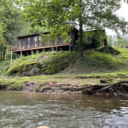
We found this campground by accident while exploring waterfalls in N. Georgia. Decided to return this week and have our first camping trip with the kids. For a first campground trip it was great. With city kiddies as my husband calls us... we had accessible bathrooms (with toilet paper) and showers within feets from our campsite. A plus when having to get up at night to bathroom! Quiet campgrounds since we were first "family " with kids to arrive. About 15 campsites available for a good price..if a GA Camp Member $6 a night. Each campsite has a gravel parking space for a trailer and vehicle. A tent space, picnic table, and fire pit/grill, and a post to hang bags (in case of bears)... yes we saw signs for active bear sightings. As long as you clean up your food ... your good. There's a trash bin available for the site as well and running water posts. As for the scenery.. beautiful. Short walking distance to Upper Falls and Lower Falls. Also in camp area..if you walk up towards Upper campsite you cross a bridge and right on left side is a trail to the creek/river. My kids loved going there to play. Water was cold but flat area great enough for water play. Definitely would camp here again! read more


13 years ago
15 years ago
More info about DeSoto Falls
Chattahoochee National Forest
Hwy 19 N
Dahlonega, GA 30533
Directions
(706) 745-6928
Call Now
Hours
Outdoor Amenities
Ask the Community - DeSoto Falls
Review Highlights - DeSoto Falls


DeSoto Falls - hiking - Updated July 2026
Best of Dahlonega
People found DeSoto Falls by searching for…
Hiking Trails With Waterfalls in Dahlonega, Georgia
Campgrounds in Dahlonega, Georgia
Things to Do in Dahlonega, Georgia
Scenic Overlook in Dahlonega, Georgia
Scenic Drive in Dahlonega, Georgia
Scenic Views in Dahlonega, Georgia
Splash Pad in Dahlonega, Georgia
Public Shower in Dahlonega, Georgia
Beautiful Views in Dahlonega, Georgia
Tent Camping in Dahlonega, Georgia
Easy Hikes in Dahlonega, Georgia
Picnic Areas in Dahlonega, Georgia
Photo Spots in Dahlonega, Georgia
Waterfalls in Dahlonega, Georgia
Dog Friendly Trails in Dahlonega, Georgia
Walking Trails in Dahlonega, Georgia
Secret Spots in Dahlonega, Georgia
Hikes With Dogs in Dahlonega, Georgia
Picnic Spots in Dahlonega, Georgia
Off Road Trails in Dahlonega, Georgia
Hiking With Kids in Dahlonega, Georgia
Trending Searches in Dahlonega, GA
Black Owned Nail Salons in Dahlonega, GA
Cliff Jumping in Dahlonega, GA
Dog Friendly Trails in Dahlonega, GA
Jet Ski Rental in Dahlonega, GA
Lakes & Ponds in Dahlonega, GA
Off Road Trails in Dahlonega, GA
Outdoor Activities in Dahlonega, GA
Places To Walk Around in Dahlonega, GA
Public Shower in Dahlonega, GA
River Swimming in Dahlonega, GA
Scenic Night View in Dahlonega, GA
Scenic Overlook in Dahlonega, GA
Secluded Spots in Dahlonega, GA
Strawberry Picking in Dahlonega, GA
Swimming Holes in Dahlonega, GA
Browse Nearby
Browse Brands
Related Searches in Dahlonega, GA
Affordable Kayak Rental Services in Dahlonega, Georgia
Best Fishing Locations and Guides in Dahlonega, Georgia
Best Nature Trails for Hiking in Dahlonega, Georgia
Best Places for Horseback Riding in Dahlonega, Georgia
Best Waterfalls and Swimming Holes in Dahlonega, Georgia
Check Out Off Road Trails in Dahlonega, Georgia
Discover Dog Friendly Trails to Explore in Dahlonega, Georgia
Discover Kid Friendly Hiking Trails in Dahlonega, Georgia
Discover Scenic Mountain Bike Trails Near Dahlonega, Georgia
Discover Scenic Waterfall Spots in Dahlonega, Georgia
Discover a Hiking Trail in Dahlonega, Georgia
Discover the Best Night Hike Trails in Dahlonega, Georgia
Discover the Best Running Track in Dahlonega, Georgia
Dog-Friendly Hikes With Dogs in Dahlonega, Georgia
Enjoy Exciting Mountain Biking Adventures in Dahlonega, Georgia
Enjoy Kayaking Adventures in Dahlonega, Georgia
Enjoy River Tubing Adventures in Dahlonega, Georgia
Enjoy Tent Camping Spots Around Dahlonega, Georgia
Enjoy a Beautiful Waterfall Hike in Dahlonega, Georgia
Enjoy the Best Family Activities in Dahlonega, Georgia
Enjoy the Best Picnic Spots and Ideas in Dahlonega, Georgia
Enjoy the Best Tubing Experiences in Dahlonega, Georgia
Enjoy the Best Walking Trails in Dahlonega, Georgia
Exciting Cliff Jumping Spots in Dahlonega, Georgia
Experience Thrilling White Water Rafting in Dahlonega, Georgia
Explore Beautiful Parks and Green Spaces in Dahlonega, Georgia
Explore Easy Hikes Perfect for All in Dahlonega, Georgia
Explore Fun Activities to Do in Dahlonega, Georgia
Explore Popular Campgrounds Near Dahlonega, Georgia
Explore Popular Scenic Overlook Points in Dahlonega, Georgia
Explore the Best Boating Spots in Dahlonega, Georgia
Explore the Best Swimming Holes Around Dahlonega, Georgia
Explore the Best Trail Options in Dahlonega, Georgia
Family Friendly Hiking With Kids in Dahlonega, Georgia
Find Beautiful Views in Dahlonega, Georgia
Find Cozy Camping Cabins in Dahlonega, Georgia
Find Popular Ziplining Spots Around Dahlonega, Georgia
Find the Best Scenic View Locations in Dahlonega, Georgia
Hiking Trails With Waterfalls in Dahlonega, Georgia
Off Leash Dog Hiking Trails in Dahlonega, Georgia
Plan a Scenic Drive Route Near Dahlonega, Georgia
Popular Fishing Spots to Explore in Dahlonega, Georgia
Popular Outdoor Activities to Try in Dahlonega, Georgia
Popular Picnic Spots to Visit in Dahlonega, Georgia
Safe River Swimming Areas in Dahlonega, Georgia
Top Climbing Spots and Gyms in Dahlonega, Georgia
Top Paddleboarding Activities in Dahlonega, Georgia
Top Running Trails to Explore in Dahlonega, Georgia
Browse Articles
People who viewed DeSoto Falls also viewed
High Shoals Falls Loop Trail
17 reviews
Woody Gap Recreation Area
11 reviews
Dicks Creek Falls
12 reviews
Swinging Bridge On The Toccoa River
8 reviews
Sea Creek Falls
1 review
Mount Yonah Trailhead
37 reviews
Brasstown Bald Tower
3 reviews
Cowrock Summit
1 review
Lookout Rock
1 review
Blood Mountain Wilderness Area
26 reviews