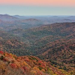
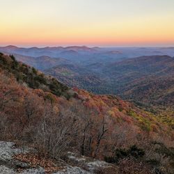
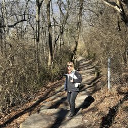
Tocca River Swinging Bridge Photos


More like Tocca River Swinging Bridge
Recommended Reviews - Tocca River Swinging Bridge
Start your review...

1 year ago
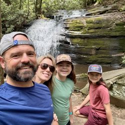
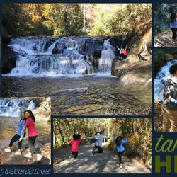
It's only a 10 minute hike to swinging bridge if you drive on the bumpy FS816 for 3 miles. The bridge was built in 1977 by the National Forest Service and crosses the Toccoa River, spanning 270 ft. This is Georgia's longest suspension bridge. It really does make you feel a little woozy crossing if your partners walk swings in tandem with the bridge. The water is refreshingly cool, in contrast to Blue Ridge Lake water. We heard about this place earlier in the year and were already in Blue Ridge so coming here was just an extra 35 minutes out of the way, but well worth seeing Georgias Longest When we crossed over the river turns in a long arch as it passes. A very nice spot to camp too, tho we heard a loud bull frog calling out heartily. This bridge is one of many features along the 300 mile white blazed Benton Mackay Trail (BMT). One day I may hike or run the whole thing. read more


This suspension bridge was built in 1977 and is the longest bridge in the Southeastern US. If you park at the end of the fire service road it's a 1/4 mile hike in. I am not a hiker due to medical issues but was able to do this. Just info for maybe people not as active. It was so worth it, absolutely beautiful. It doesn't only sway but goes up and down. I made my hubby wait until i went all the way across because the bridge was going crazy with both of us. Hold on to phones I could easily see dropping it. You have the beautiful Toccoa River underneath you. So peaceful and gorgeous. We got lucky and had the place to ourselves. *Just FYI we did see a black bear on our way out and that was exciting. read more


More info about Tocca River Swinging Bridge
Hwy 60
Blue Ridge, GA 30513
Directions
Hours
Outdoor Amenities


Tocca River Swinging Bridge - hiking - Updated July 2026
Best of Blue Ridge
People found Tocca River Swinging Bridge by searching for…
Things to Do in Blue Ridge, Georgia
Scenic Views in Blue Ridge, Georgia
Hiking Trails in Blue Ridge, Georgia
Playgrounds in Blue Ridge, Georgia
Running Trails in Blue Ridge, Georgia
Waterfalls in Blue Ridge, Georgia
Swimming Holes in Blue Ridge, Georgia
Off Road Trails in Blue Ridge, Georgia
Tent Camping in Blue Ridge, Georgia
Off Leash Dog Hikes in Blue Ridge, Georgia
Walking Trails in Blue Ridge, Georgia
Lakes & Ponds in Blue Ridge, Georgia
Scenic Overlook in Blue Ridge, Georgia
Dog Friendly Trails in Blue Ridge, Georgia
River Swimming in Blue Ridge, Georgia
Splash Pad in Blue Ridge, Georgia
Places to Take Pictures in Blue Ridge, Georgia
Trending Searches in Blue Ridge, GA
Black Owned Nail Salons near Tocca River Swinging Bridge
Boat Rental near Tocca River Swinging Bridge
Cliff Jumping near Tocca River Swinging Bridge
Day Trips near Tocca River Swinging Bridge
Dog Friendly Trails near Tocca River Swinging Bridge
Dog Swimming near Tocca River Swinging Bridge
Fishing Spots near Tocca River Swinging Bridge
Jet Ski Rental near Tocca River Swinging Bridge
Kayak Rental near Tocca River Swinging Bridge
Lakes near Tocca River Swinging Bridge
Off Road Trails near Tocca River Swinging Bridge
Outdoor Activities near Tocca River Swinging Bridge
Picnic Parks near Tocca River Swinging Bridge
Public Shower near Tocca River Swinging Bridge
River Swimming near Tocca River Swinging Bridge
River Tubing near Tocca River Swinging Bridge
Running Trails near Tocca River Swinging Bridge
Scenic Overlook near Tocca River Swinging Bridge
Splash Pad near Tocca River Swinging Bridge
Strawberry Picking near Tocca River Swinging Bridge
Swimming Holes near Tocca River Swinging Bridge
Swimming Lakes near Tocca River Swinging Bridge
Watch Sunset near Tocca River Swinging Bridge
Browse Articles
Browse Nearby
Browse Brands
Related Searches in Blue Ridge, GA
Affordable Kayak Rental Services in Blue Ridge, Georgia
Best Dog Hiking Trails Around Blue Ridge, Georgia
Best Fishing Locations and Guides in Blue Ridge, Georgia
Best Places for Horseback Riding in Blue Ridge, Georgia
Best Waterfalls and Swimming Holes in Blue Ridge, Georgia
Check Out Off Road Trails in Blue Ridge, Georgia
Discover Dog Friendly Trails to Explore in Blue Ridge, Georgia
Discover Kid Friendly Hiking Trails in Blue Ridge, Georgia
Discover Popular Bike Trails in Blue Ridge, Georgia
Discover Public Beaches to Visit in Blue Ridge, Georgia
Discover Scenic Mountain Bike Trails Near Blue Ridge, Georgia
Discover a Hiking Trail in Blue Ridge, Georgia
Discover the Best Night Hike Trails in Blue Ridge, Georgia
Dog-Friendly Hikes With Dogs in Blue Ridge, Georgia
Enjoy Camping Adventures Around Blue Ridge, Georgia
Enjoy Exciting Mountain Biking Adventures in Blue Ridge, Georgia
Enjoy Kayaking Adventures in Blue Ridge, Georgia
Enjoy Off Leash Dog Hikes in Blue Ridge, Georgia
Enjoy Tent Camping Spots Around Blue Ridge, Georgia
Enjoy the Best Walking Trails in Blue Ridge, Georgia
Experience Thrilling White Water Rafting in Blue Ridge, Georgia
Explore Beautiful Parks and Green Spaces in Blue Ridge, Georgia
Explore Easy Hikes Perfect for All in Blue Ridge, Georgia
Explore Fun Activities to Do in Blue Ridge, Georgia
Explore Popular Campgrounds Near Blue Ridge, Georgia
Explore Top Dog Parks in Blue Ridge, Georgia Near You
Explore Top Water Parks in Blue Ridge, Georgia Today
Explore the Best Swimming Holes Around Blue Ridge, Georgia
Family Friendly Hiking With Kids in Blue Ridge, Georgia
Find Beautiful Views in Blue Ridge, Georgia
Find Popular Ziplining Spots Around Blue Ridge, Georgia
Find Top-Rated Waterfalls in Blue Ridge, Georgia Now
Find the Best Playgrounds to Visit in Blue Ridge, Georgia
Hiking Trails With Waterfalls in Blue Ridge, Georgia
Off Leash Dog Hiking Trails in Blue Ridge, Georgia
Plan a Scenic Drive Route Near Blue Ridge, Georgia
Popular Outdoor Activities to Try in Blue Ridge, Georgia
Popular Picnic Spots to Visit in Blue Ridge, Georgia
Safe River Swimming Areas in Blue Ridge, Georgia
Safe and Fun Parks for Kids in Blue Ridge, Georgia
Top Dog Friendly Things to Do in Blue Ridge, Georgia
Top Hiking Trails to Explore in Blue Ridge, Georgia
Top Paddleboarding Activities in Blue Ridge, Georgia
Top Playgrounds for Kids to Enjoy in Blue Ridge, Georgia
Top Running Trails to Explore in Blue Ridge, Georgia
Top Swimming Lakes to Enjoy in Blue Ridge, Georgia