Emery Creek Trail Hiking Photos


More like Emery Creek Trail
Recommended Reviews - Emery Creek Trail
Start your review...

8 years ago
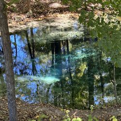
I've never had such difficulty following a trail to the point I felt like giving up, but I almost did today. - - - I've come to face some hard facts in the last few weeks that has put me in a sort of funk. A) I'm getting older B) my body isn't responding the way it used to C) I've gained more weight in the last year than the past 5 years combined D) I'm tired all the time E) Aches & pains have become full time occurrences F) I am slowly losing my will to hike (which I love) or to work out (which I hate) In an effort to lose 60 lbs before the end of the year, I have embarked on a campaign to hike off my weight. This will also include biking when I get down a few more pounds and running once I've shed 40. Why mention that? So you would know my determination to complete this trail was unwavering, although I got lost and bruised trying to follow the nearly impossible to read faded map at the parking entrance. I spent nearly an hour trying to forage my way through the woods once I missed my turn. I lost the trail as I followed the wrong path along Holly Creek and I wasn't the only one! I met two couples also lost that were coming back from where I was headed. It was treacherous, and I lost my footing several times, nearly broke my camera. I should have known the trail shouldn't be this hard, but I kept searching anyway. Scraped, battered and bruised I returned to my car feeling defeated and frustrated. "You're smarted than this Richard! Don't let this trail defeat you" I said to myself. It was then I decided to take one more look at that map, and that's when I noticed a faint white line outlining the trail, which was different that the dark dotted line I was trying to follow before. After I learned the correct path, the trail was much easier to follow. So, here's what you need to know in a nutshell: - - - FOLLOW THE CORRECT TRAIL * From the parking area, follow the trail uphill. Downhill just leads to the river. * You will come to a point in about half a mile where the creek clearly splits. As the path takes you towards the creek, look for a green blaze marker on a tree near the shore. This is where you MUST cross through the creek. * Emery Creek Trail is unlike any other trail I've been on. THERE ARE NO FOOTBRIDGES to cross water. YOU MUST go directly through the creek, which means you might want to wear shorts & water shoes with grip. Most of the crossings will bring the water just a few inches above your ankle, but there was one crossing that was practically thigh high. * The stones in the creek bed are SLIPPERY!!! BE CAREFUL!!! You can easily lose your balance. * You will cross the river again 8 times, not counting a few low volume streams. The trail is clearly visible once you know how to follow it. JUST REMEMBER that each time the trail seems to end at the river, look to the other side and you will see the trail picks up again. Sometimes you will also see a green blaze attached to the tree, but sometimes you will not. * Once you see the old abandoned truck shell, you are about 1 mile from the falls. On the last creek crossing, there will be a sign on the other side directing you to turn left for the falls or keep straight towards the overlook. * Overall it is approximately 2.5 miles one way to the lower falls and 3.1 to the upper falls. I was exhausted and running out of daylight, so I didn't spend the extra energy to see the upper falls. 6.2 miles (round trip) - - - FINAL THOUGHTS What a BEAUTIFUL waterfall. The only truly way to get a good pic will require walking through the pool at the base, but this shouldn't be a problem since you'll already be soaking wet anyway. Although there were several teens lounging near the beginning of the trail, I walked to the falls and back without ever seeing another soul. I must admit that when I got to the final crossing (which I didn't know was the final) I felt defeated. I thought maybe I'd gone too far & missed the falls. I sat on a stone contemplating turning around. I listened for the fall, but could not hear or see it. I decided to cross the creek but had made up my mind I was definitely turning around in 100 yards if I didn't see or hear anything. No sooner than I crossed the creek did I see a hidden sign directing me left to the falls. Within 200 feet of that sign the falls came into view and I could finally hear that familiar waterfall sound. I thought to myself, how many times in my life have I battled to accomplish something, only to feel defeated & turn away because I couldn't see the finish... which was closer than I thought! I love nature because it brings clarity. So, if you are reading this & you are fighting a hard battle that has you feeling defeated... take heart. Our life map can sometimes be hard to read and we make wrong turns that leave us bruised. Even on the right trail we still encounter obstacles that must be overcome. It's a long walk but don't give up. You are closer to reaching your goal than you think! 2018/30 read more

 - Hiking Near Me - Chatsworth, Georgia")


 - Hiking Near Me - Chatsworth, Georgia")
 - Hiking Near Me - Chatsworth, Georgia")


9 years ago
We loved this trail! Like the other reviews say, be prepared for a moderate intensity and to most likely get your feet wet. We crossed the river several times by managing to jump the rocks to the other side and several times by just breaking down, taking our shoes off and walking straight through the creek bed. Also once you get to the falls, we had to do what seemed like some vertical rock climbing to get to the upper levels. It can be steep! Ran into a few other hikers on the trail or camping up by the falls but for the most part it was a peaceful hike. Would only have been better if there were a few more trail markers! We were unsure where to cross at some points and had to double back a few times to find the right path. We wore our FitBits and estimated that the trail was approximately 8 miles round trip. I also brought my 12 pound Long hair Chihuahua Loki because he loves to hike. He did great even with his little legs and jumping over fallen trees. He had to be carried over the streams but otherwise he wanted to lead the way! If he can do it, we all can! read more


9 years ago
7 years ago
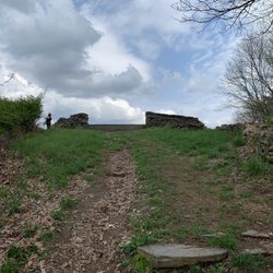
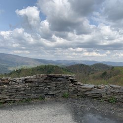
The road leading to this trail is paved for a short bit, then most of it is a dirt road. Be prepared to ride on this narrow, and winding road for about 20 minutes. I was not anticipating that it was this long and lost service about halfway down the road and almost turned around before I saw the trailhead. There is a small parking lot and no parking fee. I would categorize this hike as moderate to difficult for a couple of reasons. The trail can be hard to follow at times, especially when you get to the water crossings. Try to keep track of the green tree blazes to stay on track. The elements of this trail make it more difficult than others too. It is very rocky and full of roots. Not to mention the several times you have to cross through the water. Chacos are a must for this hike! There are no footbridges to cross the water, so you will have to walk directly in the water. If you don't have Chacos, definitely bring a change of shoes. It is about 6 miles roundtrip, but is worth every step when you arrive at the waterfall. Be sure to hike up to the upper falls. It is pretty steep, but the views are incredible. If the weather is warm enough, there is plenty of room to walk or swim near the upper falls which makes for an awesome afternoon! read more


More info about Emery Creek Trail
6025 Old Ccc Camp Rd
Chatsworth, GA 30705
Directions
Hours
Outdoor Amenities


Why does Yelp recommend reviews?
Emery Creek Trail - hiking - Updated May 2026
Best of Chatsworth
People found Emery Creek Trail by searching for…
Hiking Trails With Waterfalls in Chatsworth, GA
Places to Take Pictures in Chatsworth, GA
Rock Climbing in Chatsworth, GA
Things to Do in Chatsworth, GA
Off Road Trails in Chatsworth, GA
Waterfalls and Swimming Holes in Chatsworth, GA
Secret Spots in Chatsworth, GA
Scenic Views in Chatsworth, GA
Scenic Overlook in Chatsworth, GA
Walking Trails in Chatsworth, GA
Running Track in Chatsworth, GA
Lookout Points in Chatsworth, GA
Beautiful Views in Chatsworth, GA
River Swimming in Chatsworth, GA
Things to Do at Night in Chatsworth, GA
Swimming Lakes in Chatsworth, GA
Trending Searches in Chatsworth, GA
Baseball Fields near Emery Creek Trail
Boat Rental near Emery Creek Trail
Botanical Gardens near Emery Creek Trail
Bounce House Rentals near Emery Creek Trail
Campgrounds near Emery Creek Trail
Flower Fields near Emery Creek Trail
Lakes & Ponds near Emery Creek Trail
Mexican Catering near Emery Creek Trail
Nurseries & Gardening near Emery Creek Trail
Outdoor Furniture Stores near Emery Creek Trail
Party Equipment Rentals near Emery Creek Trail
Pedicure near Emery Creek Trail
Pick Your Own Farms near Emery Creek Trail
Picnic Areas near Emery Creek Trail
Places To Take Pictures near Emery Creek Trail
Rv Rental near Emery Creek Trail
Scenic Drive near Emery Creek Trail
Secret Spots near Emery Creek Trail
Strawberry Picking near Emery Creek Trail
Swimming Holes near Emery Creek Trail
Browse Articles
Browse Brands
Related Searches in Chatsworth, GA
Affordable Kayak Rental Services in Chatsworth, Georgia
Best Fishing Locations and Guides in Chatsworth, Georgia
Best Fun Things to Do in Chatsworth, Georgia
Best Lookout Points to Visit in Chatsworth, Georgia
Best Places for Horseback Riding in Chatsworth, Georgia
Best Places for Stunning Views in Chatsworth, Georgia
Best Spots for Star Gazing in Chatsworth, Georgia
Best Waterfalls and Swimming Holes in Chatsworth, Georgia
Check Out Off Road Trails in Chatsworth, Georgia
Discover Dog Friendly Trails to Explore in Chatsworth, Georgia
Discover Popular Photo Spots in Chatsworth, Georgia
Discover a Hiking Trail in Chatsworth, Georgia
Discover the Best Night Hike Trails in Chatsworth, Georgia
Discover the Best Running Track in Chatsworth, Georgia
Enjoy the Best Tubing Experiences in Chatsworth, Georgia
Enjoy the Best Walking Trails in Chatsworth, Georgia
Explore Beautiful Botanical Gardens in Chatsworth, Georgia
Explore Beautiful Parks and Green Spaces in Chatsworth, Georgia
Explore Easy Hikes Perfect for All in Chatsworth, Georgia
Explore Popular Campgrounds Near Chatsworth, Georgia
Explore Popular RV Parks Around Chatsworth, Georgia
Explore Scenic Lakes to Visit in Chatsworth, Georgia
Explore Top Dog Parks in Chatsworth, Georgia Near You
Explore Top Water Parks in Chatsworth, Georgia Today
Explore the Best Boating Spots in Chatsworth, Georgia
Explore the Best Swimming Holes Around Chatsworth, Georgia
Family Friendly Hiking With Kids in Chatsworth, Georgia
Find Beautiful Views in Chatsworth, Georgia
Find Fun Things to Do With Kids in Chatsworth, Georgia
Find Popular Ziplining Spots Around Chatsworth, Georgia
Find Top Skate Parks in Chatsworth, Georgia for All Skill Levels
Find the Best Playgrounds to Visit in Chatsworth, Georgia
Find the Best Swimming Pools in Chatsworth, Georgia Today
Great Places to Swim in Chatsworth, Georgia
Hiking Trails With Waterfalls in Chatsworth, Georgia
Locate Tennis Courts Around Chatsworth, Georgia
Off Leash Dog Hiking Trails in Chatsworth, Georgia
Perfect Spots to Watch Sunset in Chatsworth, Georgia
Popular Fishing Spots to Explore in Chatsworth, Georgia
Popular Kids Activities in Chatsworth, Georgia
Popular Picnic Spots to Visit in Chatsworth, Georgia
Popular Places to Take Pictures in Chatsworth, Georgia
Popular Things to Do in Chatsworth, Georgia
Relax at Natural Hot Springs Near Chatsworth, Georgia
Safe River Swimming Areas in Chatsworth, Georgia
Top Climbing Spots and Gyms in Chatsworth, Georgia
Top Running Trails to Explore in Chatsworth, Georgia
Top Swimming Lakes to Enjoy in Chatsworth, Georgia
People who viewed Emery Creek Trail also viewed
Fall Branch Falls
34 reviews
Sea Creek Falls
1 review
Tocca River Swinging Bridge
2 reviews
Blue Ridge Mountain Kayaking
31 reviews
Chattahoochre National Forest
2 reviews
Toccoa River Tubing Company
31 reviews
Blue Ridge Mountain Trail Rides
43 reviews
Flat Creek Loop
1 review
Ocoee Rafting
125 reviews
Appalachian Trail Rides
63 reviews