The Sinks Photos


You might also consider
More like The Sinks
Recommended Reviews - The Sinks
Start your review...

Reviews With Photos

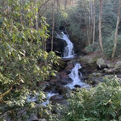
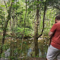
The sinks is one part of the roadside attraction of the Great Smoky Mountain National Park. It is located Little River Gorge Road. At this road there are for different water falls. Sinks is one of them. The other three falls are Meig Falls, Cane Creek Twin Falls, and White Oaks Flats Falls. The sinks is like the big drop from the rock face. The drop probably about 15 feet. Because of the sudden drop, the name call the Sinks. The parking is available and lead to the small walkway to the viewing area. It is pictured worthy location.


Excellent place to stop for a photo in The Great Smokies National Park! It has a dedicated parking lot (maybe 20 spaces) and a convenient path and viewing platform for "The Sinks". The waterfall was created by dynamite used to remove an obstruction of logs. It's a nice spot to stretch your legs if you are driving from Townsend, TN to Pigeon Forge, TN and would like to see a bit of natural splendor on the way. It was not overly crowded at 5pm on a Monday afternoon in mid-September. Be careful about swimming, which is not recommended due to the risk of drowning in the rapids.

After days of rainfall the falls have nearly disappeared, the viewing platforms are filled with people, some taking selfie's, some stare in amazement and all are in awe of the volume of water and furiousness before them. This is normally a water fall you can drive up too, no it's not one of the seven wonders of the world but the water does fall from an elevation that is greater than the elevation of the creek below and on this day it was nothing short of intense. The National Park Service has done a fine job creating a viewing platform and parking lot that allows visitors to safety exit the roadway to view one of nature's spectacular shows, on a normal day you might find people leaping off the rocks into the cool mountain stream on a day after a rain event that would be suicidal so heed the warning signs, it's likely you won't recover from a slip or fall. As much as I enjoyed my time here, it wasn't the falling water that was the attraction for me - it was watching the people watching water, now that's a real national treasure...

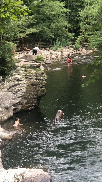
The Sinks is located in the Great Smokey Mountain National Park and it is one of the only waterfalls you can drive to. The falls are located twelve miles west of the Sugarlands Visitor Center. The sinks were formed when the Little River took an S turn creating pools that lure people in for swimming. The Sinks got their name from the swirling water caused by a fifteen foot water fall. The water at the base of the falls look like twisting sink water. In 2010 the National Park Service enhanced the Sinks by adding a new viewing platform and renovating the twenty-one space parking area. Going in the water here is advised against by the park service who has installed two ominous signs at the entrance to the falls. One states that people have drowned here due to the force of the water trapping people under hidden ledges and the other sign says not to consume too many of the small mouth bass caught here because they cause cancer. The danger of the sinks should not be underestimated. Seven people have died here since 1971. Seventeen year old Amber Mirisola from Mount Dora Fl, drowned on July 30, 2011 when she lost her footing at the top of the falls and was swept over the top and pinned underneath the falling water causing her death. In 2012, 24 year old Joshua Roberson also slipped and was carried over the falls and wedged at the bottom underneath a log where the force of the water kept him from being able to surface. Despite the warnings there were many people swimming and jumping off the rocks in to the water. The sinks are the most dangerous after a heavy rainfall. Located at the Sinks is the Meigs Creek Trail trail head, named for Colonel Returns Jonathan Meigs, Revolutionary War veteran, surveyor, and agent to the Cherokee Nation. The trail is seven miles round trip. It dead ends at 3.5 miles at the junction with the Lumber Ridge Trail and the Meigs Mountain Trail. I just waked the steps up Curry He Mountain. At the top of the trail some people said they saw a bear cub but it was gone by the time I got there. The ability to reach the Sinks by car makes it a popular place for park visitors.

Super easy access (right off the road to Cade's Cove) with its own small parking lot. Great photo opportunities. Pretty scenery. Plenty of signage warning people to stay out of the water yet we still saw adventurous climbers making their way. I'd say this is a must-see for nature/waterfall lovers, especially since it's so easy to get to. I'm pretty sure this is even wheelchair friendly. A lot of the area is paved I'm just not 100% sure if there is a ramp to get on the sidewalk.
Fun little side stop on your way to Cades Cove! The Sinks is an actual waterfall, but on some days the volume of water is so great that it just looks like a very large cascade. There is a circular viewing platform with informational sign, or you can view it from the bridge above. However, the best view for perspective is climbing down to the rivers edge, which is relatively easy. Videos and other pics online show that many people swim here in summer months, but that seems like a particularly dangerous idea on high flow days. I've seen the volume of water that comes through here first hand, and let me tell sum-ting-to-ju... it is canyon carving ferocious. There is even a sign warning of the dangers, so be wise! FINAL THOUGHTS I've been here many times before and it never gets old! It is a beautiful and scenic spot in the Smoky Mountains that requires no hiking! Anyone young or old, able-bodied or handicapped can enjoy this gorgeous little gift from mother nature with ease. Further downstream are Meig's Falls, Cane Creek Twin Falls and 13 miles away is Cades Cove, which I highly recommend visiting! 2020 / 85

Visited the sinks last weekend for the first time. It was a little crowded but not too bad. Unlike other places in the Smoky Mountains with actual side stops that are worth seeing, the sinks has dedicated parking. That being said I don't think it is wheelchair friendly. But it is available to view without having to hike four miles. It is literally right off the road and parking lot. If you're in the area it is a great stop. And if you want more than just the falls there are hiking trails that are connected to the pathway that leads to the view of the falls. Get out and see something for free!


This wonderful little fall is right off the road! This was the perfect spot since we had a wheelchair bound friend with us- so trails and hiking up to a waterfall was out of the question. This one- you just park and get out! I did dare to run out to the bridge (no sidewalks) and take a few pictures of the up river scene- which was gorgeous. Just being able to have Nicole see some waterfalls while we were in these amazing mountains made the entire trip that much better! There are trails off of this parking lot too! and I wandered a bit for some photos. Highly recommend you check out all of the waterfalls in the area if you are able and have the time!

You do not have to hike to see this beautiful waterfall. Stay on the Little River Road until you see the sign for The Sinks, Park your car in the parking and walk several steps down and you will be able to see the Falls! I think this is one of the easiest Falls you can see in Great Smoky Mountain.


1 month ago
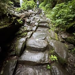
I never met a waterfall that I didn't like. We did a driving tour along Little River in Great Smoky Mountains National Park to see if we could spot some wildlife. The Sinks is a lovely waterfall along the river. There is a small parking lot with about a dozen spaces where we found parking. An observation area is a short walk from parking. A sign describes the area and that the falls were manmade. During the late 1800's the river was used to transport logs/timber to the nearby town of Elkmont. After a storm, flood waters caused a jam in the river. Dynamite was used to restore water flow. The blast resulted in a twist in the river and creation of the waterfall. A set of stone steps leads up a hill, offering lovey views of the falls. There are dozens of waterfalls in the Park. Sinks is one of the few that is drivable, which is great for people that cannot hike. I picked up a Waterfalls map at the visitor center that I found interesting and informative. Parking passes are required to park in the lot. There are no amenities at the falls. Plan 15-30 minutes for a stop and photos. read more


The Sinks is such a fun outdoor experience! Our boys, ages 11 & 13, loved it! The parking is not great though, with only about 15 spots in the parking lot and nowhere else to go. It's super busy in the summer, so just be prepared for that. We had to wait about 15 minutes for someone to leave so we could park. That wouldn't keep us from going back, though. read more


1 year ago
Beautiful waterfalls with a small parking lot within the Smoky mountain national park. There are 3 trails from this location as well. Can get quite busy. Absolutely no swimming. There are signs that say the waters have claimed several lives. Do not attempt to enter. Keep close eye on children. read more


5 months ago
The sinks is one part of the roadside attraction of the Great Smoky Mountain National Park. It is located Little River Gorge Road. At this road there are for different water falls. Sinks is one of them. The other three falls are Meig Falls, Cane Creek Twin Falls, and White Oaks Flats Falls. The sinks is like the big drop from the rock face. The drop probably about 15 feet. Because of the sudden drop, the name call the Sinks. The parking is available and lead to the small walkway to the viewing area. It is pictured worthy location. read more


7 months ago
So much fun! Went with our 10U baseball team and families. Water was a little chilly but once in felt amazing! Waterfall jump was so much fun! We'll definitely go back next year. read more


4 years ago
Excellent place to stop for a photo in The Great Smokies National Park! It has a dedicated parking lot (maybe 20 spaces) and a convenient path and viewing platform for "The Sinks". The waterfall was created by dynamite used to remove an obstruction of logs. It's a nice spot to stretch your legs if you are driving from Townsend, TN to Pigeon Forge, TN and would like to see a bit of natural splendor on the way. It was not overly crowded at 5pm on a Monday afternoon in mid-September. Be careful about swimming, which is not recommended due to the risk of drowning in the rapids. read more


After days of rainfall the falls have nearly disappeared, the viewing platforms are filled with people, some taking selfie's, some stare in amazement and all are in awe of the volume of water and furiousness before them. This is normally a water fall you can drive up too, no it's not one of the seven wonders of the world but the water does fall from an elevation that is greater than the elevation of the creek below and on this day it was nothing short of intense. The National Park Service has done a fine job creating a viewing platform and parking lot that allows visitors to safety exit the roadway to view one of nature's spectacular shows, on a normal day you might find people leaping off the rocks into the cool mountain stream on a day after a rain event that would be suicidal so heed the warning signs, it's likely you won't recover from a slip or fall. As much as I enjoyed my time here, it wasn't the falling water that was the attraction for me - it was watching the people watching water, now that's a real national treasure... read more


The Sinks is located in the Great Smokey Mountain National Park and it is one of the only waterfalls you can drive to. The falls are located twelve miles west of the Sugarlands Visitor Center. The sinks were formed when the Little River took an S turn creating pools that lure people in for swimming. The Sinks got their name from the swirling water caused by a fifteen foot water fall. The water at the base of the falls look like twisting sink water. In 2010 the National Park Service enhanced the Sinks by adding a new viewing platform and renovating the twenty-one space parking area. Going in the water here is advised against by the park service who has installed two ominous signs at the entrance to the falls. One states that people have drowned here due to the force of the water trapping people under hidden ledges and the other sign says not to consume too many of the small mouth bass caught here because they cause cancer. The danger of the sinks should not be underestimated. Seven people have died here since 1971. Seventeen year old Amber Mirisola from Mount Dora Fl, drowned on July 30, 2011 when she lost her footing at the top of the falls and was swept over the top and pinned underneath the falling water causing her death. In 2012, 24 year old Joshua Roberson also slipped and was carried over the falls and wedged at the bottom underneath a log where the force of the water kept him from being able to surface. Despite the warnings there were many people swimming and jumping off the rocks in to the water. The sinks are the most dangerous after a heavy rainfall. Located at the Sinks is the Meigs Creek Trail trail head, named for Colonel Returns Jonathan Meigs, Revolutionary War veteran, surveyor, and agent to the Cherokee Nation. The trail is seven miles round trip. It dead ends at 3.5 miles at the junction with the Lumber Ridge Trail and the Meigs Mountain Trail. I just waked the steps up Curry He Mountain. At the top of the trail some people said they saw a bear cub but it was gone by the time I got there. The ability to reach the Sinks by car makes it a popular place for park visitors. read more


Super easy access (right off the road to Cade's Cove) with its own small parking lot. Great photo opportunities. Pretty scenery. Plenty of signage warning people to stay out of the water yet we still saw adventurous climbers making their way. I'd say this is a must-see for nature/waterfall lovers, especially since it's so easy to get to. I'm pretty sure this is even wheelchair friendly. A lot of the area is paved I'm just not 100% sure if there is a ramp to get on the sidewalk. read more


6 years ago
Fun little side stop on your way to Cades Cove! The Sinks is an actual waterfall, but on some days the volume of water is so great that it just looks like a very large cascade. There is a circular viewing platform with informational sign, or you can view it from the bridge above. However, the best view for perspective is climbing down to the rivers edge, which is relatively easy. Videos and other pics online show that many people swim here in summer months, but that seems like a particularly dangerous idea on high flow days. I've seen the volume of water that comes through here first hand, and let me tell sum-ting-to-ju... it is canyon carving ferocious. There is even a sign warning of the dangers, so be wise! FINAL THOUGHTS I've been here many times before and it never gets old! It is a beautiful and scenic spot in the Smoky Mountains that requires no hiking! Anyone young or old, able-bodied or handicapped can enjoy this gorgeous little gift from mother nature with ease. Further downstream are Meig's Falls, Cane Creek Twin Falls and 13 miles away is Cades Cove, which I highly recommend visiting! 2020 / 85 read more


Visited the sinks last weekend for the first time. It was a little crowded but not too bad. Unlike other places in the Smoky Mountains with actual side stops that are worth seeing, the sinks has dedicated parking. That being said I don't think it is wheelchair friendly. But it is available to view without having to hike four miles. It is literally right off the road and parking lot. If you're in the area it is a great stop. And if you want more than just the falls there are hiking trails that are connected to the pathway that leads to the view of the falls. Get out and see something for free! read more

2 years ago
4 years ago
I could have spent all day here. The history of how The Sinks was formed is fascinating. The trail was lush and inviting. We did not hike the entire loop but would plan to next time. read more


4 years ago
It's a nice stop along the way while touring the Smoky Mountains National Park. There is a little parking area. It's really relaxing to hike a little bit around the falls read more

7 years ago
This wonderful little fall is right off the road! This was the perfect spot since we had a wheelchair bound friend with us- so trails and hiking up to a waterfall was out of the question. This one- you just park and get out! I did dare to run out to the bridge (no sidewalks) and take a few pictures of the up river scene- which was gorgeous. Just being able to have Nicole see some waterfalls while we were in these amazing mountains made the entire trip that much better! There are trails off of this parking lot too! and I wandered a bit for some photos. Highly recommend you check out all of the waterfalls in the area if you are able and have the time! read more


7 years ago
You do not have to hike to see this beautiful waterfall. Stay on the Little River Road until you see the sign for The Sinks, Park your car in the parking and walk several steps down and you will be able to see the Falls! I think this is one of the easiest Falls you can see in Great Smoky Mountain. read more

5 years ago
Want to see more beauty....stop at the sinks. It's a swimming hole for a lot of the locals, but it has an amazing waterfall. It's so beautiful. You won't want to miss the photo of for sure. read more

5 years ago
Great stop before we headed home. Loved how easy it was to get to on our drive out of the smokies. The walk is easy for all ages around. Careful with young children water moves very fast. read more


3 years ago
We visited The Sinks in March and it was beautiful. The weather was great and we had no issues finding parking. We did stop by Sugarlands Visitor center first to purchase a parking pass. It was $5 for the day and can be purchased from outside at the machines or inside the gift shop. From the visitor center, you drive about 11 miles before arriving at The Sinks. Once you park, you walk up and are immediately there. There are several great spots to get pictures. Off to the left, you can take some steps that lead to 3 trails. Although we did not fully complete any of the trails due to time, we loved having the option to go as far as we wanted and easily turn around when needed. We did find a small Pygmy salamander on our hike. The trail did have some roots on it and you do cross some small rivers by stepping on rocks. read more


7 years ago
Gorgeous! Lots of places to go off the beaten path and explore. You can get on the rocks right by the water and explore little feeder streams Some kids were exploring out on the little island but you have to either walk in the water or risk slipping on a bunch of wet rocks so I don't think I would advise going out there. read more


Let's just to say, I found a gem that Yelp hasn't! Hurrah! I win. I came here with some friends that showed me this gem, and definitely it's pretty neat. So, what's here? Let's just go ahead and get the dangerous details out of the way: Don't be dumb and try to climb under the waterfall because people have died. Done! However, if you want to go on top of that rock and jump down where the rapids aren't crazy, go for it. It's pretty deep, even when the water is low, I checked. *Warning: If the water is super low, and you get impaled by a tree, I'm not responsible. Heed caution!* Now, other than that there's a nice swimming hole and when the water level is higher, it's definitely a place to check out. Bring a tube, and float down the river, or just lounge. Even though when I went the level was quite low, I still got to go swimming a little and had a little bit of exercise. If you bring goggles, you'll definitely see some fish down there swimming around because I did! There's a nice photo op here as well, if you're driving by. I would recommend if you want to go by the water and check it out. *NOTE: Parking is limited. It's a hit or miss. There is parking here but if it's busy, I doubt you'll find one, unless the parking gods are on your side.* read more


6 years ago
This is a beautiful area for sights and cliff jumping! My eleven year old had a blast and we loved the beautiful scenery! read more

6 years ago
The first half is up Megs Mountain trail is straight up hill. Remember its not a race if you want to get the the waterfall. Its about 2 miles in. Not the full trail. The sinks are right at the parking lot. Not a lot of space to park so get there early. We had to just sit in the back of the lot and wait for someone to leave. It seemed like cars will leave every few minutes, just your patient. Also people were jumping off a Boulder. Looked lime fun, but i was dressed for it. Next time for sure. read more


3 years ago
8 years ago
Believe it or not we had more fun here than at Dollywood. I'm not saying Dollywood wasn't a blast because it was ! This is a locals spot it's only about 20 minutes from Pigeon Forge. Did I mention it's FREE? Parking is scarce that's the only bad thing it's a small parking lot. You can literally see the area from where you park. The waterfall is beautiful you don't want to swim near the falls since there have been many that have drowned near them! Now there is plenty space to swim and relax in the refreshing cold water. There are two cliffs to cliff jump from. We had our first cliff jumping experience. I have to admit I was a little scared since I have a fear of heights but I'm not going to let that stop me from experiencing life! I did jump from the lower cliff. My husband of course had to jump from both. We had a blast here and if you are going to Pigeon Forge or Gatlinburg don't miss this free family activity! read more


4 years ago
6 years ago
This was such a beautiful hiking area, if I could give it twelve stars I would! It's a breathtaking view once you really start getting bigger up the mountain. read more


7 years ago
This place was awesome. Some directions will tell you that it's only 14 miles out from the visitor center but it's actually 16 miles. 100% worth the drive. A great place to go swim in the summer especially after hiking. Another great option is to find a tubing company in Townsend and tube down that river. A great experience. read more


7 years ago
Meigs Mountain Trail was beautiful! We have saw the trails next to the sinks on previous visits. Highly recommend. read more


5 years ago
If you're looking for the easiest way to see a waterfall, go swimming, and even jump off a cliff, the sinks is the place to go! We found this beautiful place and decided to give it a shot. It was a beautiful drive on the way there. We went later in the afternoon. It seemed as though we just missed the huge crowd from the day. Parking is very limited, but we have gone 3 times around 4pm and we're able to get a spot. This is a wonderful spot for older people & children who can't endure a long hike to a waterfall. Here, you just drive up and the waterfall is right on the side of the road. We were able to hike down a bit and go swimming in the water & even jump off the cliffs! Definitely one of the best places in the Gatlinburg area. read more


9 years ago
Tranquility. So many trail options to walk through. The water is so clear I wanted to jump in even though it was freezing cold. Can't wait to go back. Please be mindful of your step. Be prepared to climb down steep hills to get the the sinks and climb back up with no trails. read more

5 years ago
7 years ago
7 years ago
10 years ago
More info about The Sinks
Little River Gorge Rd
Gatlinburg, TN 37738
Directions
Hours
Indoor Amenities
Outdoor Amenities
Ask the Community - The Sinks
Review Highlights - The Sinks


The Sinks - parks - Updated May 2026
Best of Gatlinburg
People found The Sinks by searching for…
Cliff Jumping in Gatlinburg, Tennessee
Scenic View in Gatlinburg, Tennessee
Scenic Drive in Gatlinburg, Tennessee
Secret Spots in Gatlinburg, Tennessee
Places to Swim in Gatlinburg, Tennessee
Waterfall in Gatlinburg, Tennessee
Canyoneering in Gatlinburg, Tennessee
Hiking Trails Kid Friendly in Gatlinburg, Tennessee
Creeks in Gatlinburg, Tennessee
Places to Walk at Night in Gatlinburg, Tennessee
Nature in Gatlinburg, Tennessee
Scenic Spots in Gatlinburg, Tennessee
Walking Groups in Gatlinburg, Tennessee
Romantic Picnic Secluded in Gatlinburg, Tennessee
Running Stairs in Gatlinburg, Tennessee
Park & Forests in Gatlinburg, Tennessee
Shaded Hike in Gatlinburg, Tennessee
Hidden Beach in Gatlinburg, Tennessee
Outdoor Exercise Parks in Gatlinburg, Tennessee
Pokemon Go in Gatlinburg, Tennessee
Sand Volleyball Courts in Gatlinburg, Tennessee
Picnic Areas BBQ Pits in Gatlinburg, Tennessee
Trending Searches in Gatlinburg, TN
Baseball Fields near The Sinks
Botanical Gardens near The Sinks
Bounce House Rentals near The Sinks
Floral Designers near The Sinks
Kids Friendly Beaches near The Sinks
Nurseries & Gardening near The Sinks
Outdoor Activities near The Sinks
Outdoor Basketball Courts near The Sinks
Outdoor Furniture Stores near The Sinks
Party Equipment Rentals near The Sinks
Places To Take Pictures near The Sinks
Public Running Track near The Sinks
Table And Chair Rentals near The Sinks
Browse Brands
Related Searches in Gatlinburg, TN
Affordable Kayak Rental Services in Gatlinburg, Tennessee
Best Fishing Locations and Guides in Gatlinburg, Tennessee
Best Nature Trails for Hiking in Gatlinburg, Tennessee
Best Parks for Parties and Events in Gatlinburg, Tennessee
Best Places for Horseback Riding in Gatlinburg, Tennessee
Best Water Parks for Kids in Gatlinburg, Tennessee
Best Waterfalls and Swimming Holes in Gatlinburg, Tennessee
Check Out Great Playgrounds in Gatlinburg, Tennessee
Check Out Off Road Trails in Gatlinburg, Tennessee
Discover Baseball Fields Around Gatlinburg, Tennessee
Discover Dog Friendly Trails to Explore in Gatlinburg, Tennessee
Discover Fun Activities to Do in Gatlinburg, Tennessee
Discover Lakes & Ponds to Explore in Gatlinburg, Tennessee
Discover Popular Photo Spots in Gatlinburg, Tennessee
Discover Scenic Mountain Bike Trails Near Gatlinburg, Tennessee
Discover Scenic Waterfall Spots in Gatlinburg, Tennessee
Discover Top Nature Parks to Visit in Gatlinburg, Tennessee
Discover a Hiking Trail in Gatlinburg, Tennessee
Discover the Best Beaches in Gatlinburg, Tennessee
Discover the Best Night Hike Trails in Gatlinburg, Tennessee
Discover the Best Running Track in Gatlinburg, Tennessee
Dog-Friendly Hikes With Dogs in Gatlinburg, Tennessee
Enjoy Camping Adventures Around Gatlinburg, Tennessee
Enjoy Exciting Mountain Biking Adventures in Gatlinburg, Tennessee
Enjoy Kayaking Adventures in Gatlinburg, Tennessee
Enjoy Tent Camping Spots Around Gatlinburg, Tennessee
Enjoy a Beautiful Waterfall Hike in Gatlinburg, Tennessee
Enjoy the Best Family Activities in Gatlinburg, Tennessee
Enjoy the Best Tubing Experiences in Gatlinburg, Tennessee
Enjoy the Best Walking Trails in Gatlinburg, Tennessee
Exciting Cliff Jumping Spots in Gatlinburg, Tennessee
Experience Thrilling White Water Rafting in Gatlinburg, Tennessee
Explore Beautiful Parks and Green Spaces in Gatlinburg, Tennessee
Explore Easy Hikes Perfect for All in Gatlinburg, Tennessee
Explore Family-Friendly Zoos and Wildlife in Gatlinburg, Tennessee
Explore Free Picnic Areas Around Gatlinburg, Tennessee
Explore Fun Activities to Do in Gatlinburg, Tennessee
Explore Popular Campgrounds Near Gatlinburg, Tennessee
Explore Popular Picnic Areas Around Gatlinburg, Tennessee
Explore Popular RV Parks Around Gatlinburg, Tennessee
Explore Popular Recreation Centers Around Gatlinburg, Tennessee
Explore Popular Scenic Views Near Gatlinburg, Tennessee
Explore Scenic Lakes to Visit in Gatlinburg, Tennessee
Explore Secret Spots Worth Visiting in Gatlinburg, Tennessee
Explore Top Dog Parks in Gatlinburg, Tennessee Near You
Explore Top Gyms in Gatlinburg, Tennessee Now
Explore Top Water Parks in Gatlinburg, Tennessee Today
Explore the Best Boating Spots in Gatlinburg, Tennessee
Explore the Best Swimming Holes Around Gatlinburg, Tennessee