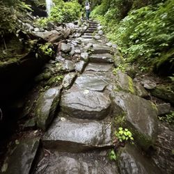
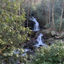
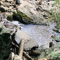
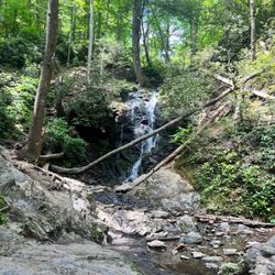
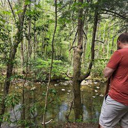
Rainbow Falls Photos


You might also consider
More like Rainbow Falls
Recommended Reviews - Rainbow Falls
Start your review...

Reviews With Photos

Rainbow Falls is a great hike in the Smokey mountains it took us about 3.5 hours and a total of 6.5 miles. It is a lot of uphill hiking so if you don't have much experience hiking I wouldn't recommend it. There isn't much parking but they do have a couple of different parking lots. There are bathrooms at the trailhead. It is a very scenic hike and the day we went it was very foggy and rainy. One of the best hikes you can go on while you are in the Smokeys.

It's a long hard hike but if you can get past this you will see a very beautiful waterfall with a background of multi-colored rock. It is uphill the entirety of the hike and there are a lot of rocks and roots in the path that make it difficult to walk easily but the view makes it all worth it.

Rainbow Falls Trailhead - 1 Tyler - 0 This. trail. kicked. my. ass. All the people talking about this trail being "moderately difficult" are liars and shouldn't be trusted. Having said that, it was a great hike. Your hike back will be much more pleasant than the hike to the falls as the first leg is ENTIRELY uphill. My feet hurt, my thighs hurt, my legs hurt, it all hurt, I hated everything. While the trail claims to be 2.7 miles long (each way), it felt like a very steep 2.7 miles and my apple watched clocked it at over 3 miles each way. The trip back down was MUCH easier/pleasant as it was all downhill. The views and the falls were beautiful. If you're planning on doing this trailhead, here's a few tips: 1) This is not a beginners trail. If you're looking for something more leisurely, this is not the trail for you. You will sweat, it will hurt, you'll begin to debate whether or not the falls are worth it. 2) Bring plenty of water/snacks. We passed lots of people who clearly came unprepared/without water/boots/backpacks. I had a bag with water and a snack and wished that I had more water halfway through. 3) Arrive early. This is not a trail that you would want to hike in the dark. Make sure that you allow for plenty of time to complete the trail before the sun sets. While the trail destroyed me, I thoroughly enjoyed it. It felt great to take a shower after, relax, and unwind. Would definitely recommend this trail to others if you're up for a bit of a challenge!

Great hike, very strenuous due to terrain and inclines. Board at the entrance is very misleading and states the hike is 2.6 miles. I tracked an 8 mile round trip and another hiker I met tracked an 8.2mile round trip. You will definitely want to wear hiking boots for this, bring plenty of water, and snacks too so you can relax and energize before heading back. If you are able to make it, the top is well worth it. PS: there will be a sign that says rainbow falls when you make it. A lot of people climb all the way up just to turn around at the small falls which is only 5 minutes from the top.

**5.2 mile round trip** Well-maintained trail, no water or restrooms as you are walking through the forest. Go slow and take your time and the various waterfalls were worth it. There are roots, stumps, and rocks so watch your ankles. We hiked with a 46 year old, a 44 year old, 15 and 12 year old and it took us four hours total. Pictures and the falls were great! When sun was out it was hot so also recommend hats and plenty of water.

Beautiful hike. Just a side note to runners - I'm a runner too -but not that day-please follow trail etiquette. Yield to walkers, pass on the left , announce yourself when passing, let hikers going up have the right away. Hiked this with my husband and visually impaired sister and her husband. We were hiking single file and was passed by a runner on the right side and almost knocked us down. Then when he was coming down and tried to pass again on the inside. When confronted he said there's no rules on the trail. Eek he looked to be in his late forties and continued to argue with us. Just be mindful of trail etiquette. Such a beautiful hike though and my sister did great !!! Saw some deer and the falls were flowing.

Gorgeous hike, tho busy even in mid week September, wasn't overly crowded at the top with the massive waterfall offering and well earned misty vista. A few parts are tricky and a good energy is needed to move along at some speed but most will easily do a moderate pace without a problem, well made trail running shoes are an ideal. There's lots of nice spots to relax too with large boulders alongside the very well kept trail.

What a fun hike! I have heard about Rainbow Falls forever and for some reason, in my 11 years living in Asheville had never been until last weekend. A trip I had planned to go to Panthertown Valley didn't go as expected and I had remembered driving past a sign on the way there that said "Gorges State Park 1 mile." My friend and I decided to go see what that was and I was so pleased to find out that it was actually the Rainbow Falls Trailhead! There is a parking lot and the trail is easy to find and is clearly marked the entire hike. Upon entering the trail, you'll see many signs warning you to stay on the trail with a danger of death. I have heard of many deaths happenings here over the years and I am both a rule-follower and a scaredy cat, so you better believe I stayed on the trails! The hike is 1.5 miles in to Rainbow falls and another 1.5 back to the parking lot (aka 3 miles total). I hear that if you keep hiking, you'll come to Stairway Falls just another 1/2 mile up but my friend and I didn't do that. The sound as you arrive at the Rainbow falls was magical! Glorious, gigantic, rambling Rainbow Falls! It is 150 foot of water rushing beauty! I was actually surprised at how huge it was. Lucky for us, it had been raining a lot lately and the waterfall was rushing. We found a spot to sit and just stared at it in wonder and awe for about 20 minutes before heading back. The hike itself is medium difficulty. If you're out of shape like me, you will definitely be breathing heavy and struggling to keep conversation going for a few parts but if you're like my exercise-crazy friend, you'll be hiking up the trails like a rockstar. It is an odd trail because you're actually going downhill for a majority of the hike in. You know what that means--hiking upward for most of the way back to the car. It is a well-maintained hiking trail. This was a great hike and I'll definitely be back again!

What a challenging and rewarding hike! It is a very difficult hike to the falls as it is a steep relentless grade for almost 3 mi. nonstop. Be sure to pack plenty of water. I saw other reviews ahead of time stating the distance was 8+ mi. although the signs state 2.7 mi each way. That almost deterred me from going and boy am I glad I went! My Apple Watch was spot on with the posted signs. It does take a little longer then you would expect due to the difficulty. Once at the top we took time to climb around the falls and take a dip in the cold mountain top water. The way back down was less than half the time climbing up. I would probably do it again just to play in the falls at the top!

TIP: this isn't a trail for people that occasionally hike. We are avid walkers and this KILLED our legs the next day. It was nothing but rocky terrain all uphill. We had to stop nearly every 100 feet to catch our breath. But the waterfall was worth it and was a rewarding experience. On the way down be careful it is very rocky and We nearly rolled our ankles 10 times. Overall good hike but start early. We started at 3 and didn't get back to our truck until 7. Also keep in mind parking is VERY L

Let me start out by saying I am not an outdoorsy person. My expectation for this trail head was very low. However, I was pleasantly surprised. The trail is well laid out and well signed. Going up was all uphill and coming down was all downhill. It is 5 1/2 miles total, but takes a little longer to get through than anticipated. There are several bridges and quite a few nice picture points. I actually really enjoyed the trail. The falls once you get to them, you can go up to the top with the falls are, but I did not do this and just admired them from below. The hike was also very nice when it came to the temperature of the outdoors since it is well shaded. During our hike we saw several families with small young children doing the hike. I do not recommend this since it is a very long hike and can be strenuous at times. However, for everyone else I highly recommend this trail! This is a definite must try if you are in the Smokies. One family also saw there's while on the trail, though we did not.

Ngl the waterfall was not worth the trek compared to the scenery leading up to it. If your group gets tired a mile or mile and a half in, just turn around. I repeat DO NOT think that you should stick it out because the waterfall will make it worth it. Pack it up. Go home. The sights unseen will not haunt you.


3 months ago
I wasn't expecting the 5.6 mile hike to Rainbow Falls to be strenuous, but it was. The 2.7 mile trail winds 1500' up the mountains and is rocky and root covered. In spots, the trail was muddy and slippery. We forded two creeks along the trail and saw several small waterfalls before siting Rainbow Falls. Rainbow Falls is beautiful, falling 75' over an impressive cliff. Huge rocks offer great photos. We did not see the "rainbow" from the mist, but the sun was low in the sky. Along the trail were blooming spring wild flowers, rhododendrons, hemlock and fern starting to emerge. The trail follows a lovely creek. The hike took us three hours up and two hours back down. We were traveling with a five year old that wanted to be carried most of the way up. We stopped several times to take breaks. Fortunately, the day was cool and clear. The air gets thin the higher you climb and it is easy to get winded. I recommend bringing a walking stick, good hiking books and water. We did not encounter bugs, but maybe later in the season, hikers need bug spray. Parking is inadequate for the number of hikers. We circled several times before finding a spot. Parking passes are required for parking. There is a rustic restroom near the parking lot and that is the only facility along the trail. Like most of the Park, there is no mobile phone reception, so purchasing a Park map is useful. Despite being sore the next day, Rainbow Falls will be one of my best memories of my visit to Great Smoky Mountain National Park. read more


8 months ago
This was a great hike and the scenery was amazing! LOVED this one. The hike is about 6.5 miles roundtrip and is mostly uphill all the way up, so plan on that. All the rocks on the ground were slippery and there were a ton of those, so watch where you are walking. This one is more of a moderately hard hike for the elevation and the rocks throughout. Parking was hard to find when we came, so plan accordingly. There are multiple lots and both were full. We ended up parking a mile a way and walking to this trailhead. There is a bathroom at the trailhead. read more


It's been a while since I have been hiking, and this trail kicked my butt. I left my hiking boots at home, but I figured my sneakers would be fine. I figured out I was wrong once it started raining and all the rocks became extremely slippery. I brought a 40 oz water bottle but ran out of water about 2 miles in. Everything I saw on the internet about this trail said it was "moderately difficult". I would like to let you all know that this is a lie. Don't get me wrong, it's not the most difficult hike ever, but it was harder than our group thought. Just be aware of what you are signing up for. We saw many groups hiking that did not have appropriate footwear or bring water. The sign at the trailhead said it was 2.6 miles to the falls, but our phones registered around 3 miles each way. The trail is gorgeous with lots of scenic views. The parking is limited, and the road to get to the trail is one-way, so you cannot circle for parking. This hike is gorgeous, and it was definitely worth doing. I will definitely be more prepared next time if I ever visit this trail again. read more


Rainbow Falls is a great hike in the Smokey mountains it took us about 3.5 hours and a total of 6.5 miles. It is a lot of uphill hiking so if you don't have much experience hiking I wouldn't recommend it. There isn't much parking but they do have a couple of different parking lots. There are bathrooms at the trailhead. It is a very scenic hike and the day we went it was very foggy and rainy. One of the best hikes you can go on while you are in the Smokeys. read more


2 years ago
It's a long hard hike but if you can get past this you will see a very beautiful waterfall with a background of multi-colored rock. It is uphill the entirety of the hike and there are a lot of rocks and roots in the path that make it difficult to walk easily but the view makes it all worth it. read more

Rainbow Falls Trailhead - 1 Tyler - 0 This. trail. kicked. my. ass. All the people talking about this trail being "moderately difficult" are liars and shouldn't be trusted. Having said that, it was a great hike. Your hike back will be much more pleasant than the hike to the falls as the first leg is ENTIRELY uphill. My feet hurt, my thighs hurt, my legs hurt, it all hurt, I hated everything. While the trail claims to be 2.7 miles long (each way), it felt like a very steep 2.7 miles and my apple watched clocked it at over 3 miles each way. The trip back down was MUCH easier/pleasant as it was all downhill. The views and the falls were beautiful. If you're planning on doing this trailhead, here's a few tips: 1) This is not a beginners trail. If you're looking for something more leisurely, this is not the trail for you. You will sweat, it will hurt, you'll begin to debate whether or not the falls are worth it. 2) Bring plenty of water/snacks. We passed lots of people who clearly came unprepared/without water/boots/backpacks. I had a bag with water and a snack and wished that I had more water halfway through. 3) Arrive early. This is not a trail that you would want to hike in the dark. Make sure that you allow for plenty of time to complete the trail before the sun sets. While the trail destroyed me, I thoroughly enjoyed it. It felt great to take a shower after, relax, and unwind. Would definitely recommend this trail to others if you're up for a bit of a challenge! read more


5 years ago
Great hike, very strenuous due to terrain and inclines. Board at the entrance is very misleading and states the hike is 2.6 miles. I tracked an 8 mile round trip and another hiker I met tracked an 8.2mile round trip. You will definitely want to wear hiking boots for this, bring plenty of water, and snacks too so you can relax and energize before heading back. If you are able to make it, the top is well worth it. PS: there will be a sign that says rainbow falls when you make it. A lot of people climb all the way up just to turn around at the small falls which is only 5 minutes from the top. read more


3 years ago
**5.2 mile round trip** Well-maintained trail, no water or restrooms as you are walking through the forest. Go slow and take your time and the various waterfalls were worth it. There are roots, stumps, and rocks so watch your ankles. We hiked with a 46 year old, a 44 year old, 15 and 12 year old and it took us four hours total. Pictures and the falls were great! When sun was out it was hot so also recommend hats and plenty of water. read more

Beautiful hike. Just a side note to runners - I'm a runner too -but not that day-please follow trail etiquette. Yield to walkers, pass on the left , announce yourself when passing, let hikers going up have the right away. Hiked this with my husband and visually impaired sister and her husband. We were hiking single file and was passed by a runner on the right side and almost knocked us down. Then when he was coming down and tried to pass again on the inside. When confronted he said there's no rules on the trail. Eek he looked to be in his late forties and continued to argue with us. Just be mindful of trail etiquette. Such a beautiful hike though and my sister did great !!! Saw some deer and the falls were flowing. read more

Gorgeous hike, tho busy even in mid week September, wasn't overly crowded at the top with the massive waterfall offering and well earned misty vista. A few parts are tricky and a good energy is needed to move along at some speed but most will easily do a moderate pace without a problem, well made trail running shoes are an ideal. There's lots of nice spots to relax too with large boulders alongside the very well kept trail. read more


What a fun hike! I have heard about Rainbow Falls forever and for some reason, in my 11 years living in Asheville had never been until last weekend. A trip I had planned to go to Panthertown Valley didn't go as expected and I had remembered driving past a sign on the way there that said "Gorges State Park 1 mile." My friend and I decided to go see what that was and I was so pleased to find out that it was actually the Rainbow Falls Trailhead! There is a parking lot and the trail is easy to find and is clearly marked the entire hike. Upon entering the trail, you'll see many signs warning you to stay on the trail with a danger of death. I have heard of many deaths happenings here over the years and I am both a rule-follower and a scaredy cat, so you better believe I stayed on the trails! The hike is 1.5 miles in to Rainbow falls and another 1.5 back to the parking lot (aka 3 miles total). I hear that if you keep hiking, you'll come to Stairway Falls just another 1/2 mile up but my friend and I didn't do that. The sound as you arrive at the Rainbow falls was magical! Glorious, gigantic, rambling Rainbow Falls! It is 150 foot of water rushing beauty! I was actually surprised at how huge it was. Lucky for us, it had been raining a lot lately and the waterfall was rushing. We found a spot to sit and just stared at it in wonder and awe for about 20 minutes before heading back. The hike itself is medium difficulty. If you're out of shape like me, you will definitely be breathing heavy and struggling to keep conversation going for a few parts but if you're like my exercise-crazy friend, you'll be hiking up the trails like a rockstar. It is an odd trail because you're actually going downhill for a majority of the hike in. You know what that means--hiking upward for most of the way back to the car. It is a well-maintained hiking trail. This was a great hike and I'll definitely be back again! read more


5 years ago
What a challenging and rewarding hike! It is a very difficult hike to the falls as it is a steep relentless grade for almost 3 mi. nonstop. Be sure to pack plenty of water. I saw other reviews ahead of time stating the distance was 8+ mi. although the signs state 2.7 mi each way. That almost deterred me from going and boy am I glad I went! My Apple Watch was spot on with the posted signs. It does take a little longer then you would expect due to the difficulty. Once at the top we took time to climb around the falls and take a dip in the cold mountain top water. The way back down was less than half the time climbing up. I would probably do it again just to play in the falls at the top! read more


4 years ago
TIP: this isn't a trail for people that occasionally hike. We are avid walkers and this KILLED our legs the next day. It was nothing but rocky terrain all uphill. We had to stop nearly every 100 feet to catch our breath. But the waterfall was worth it and was a rewarding experience. On the way down be careful it is very rocky and We nearly rolled our ankles 10 times. Overall good hike but start early. We started at 3 and didn't get back to our truck until 7. Also keep in mind parking is VERY L read more


7 years ago
Let me start out by saying I am not an outdoorsy person. My expectation for this trail head was very low. However, I was pleasantly surprised. The trail is well laid out and well signed. Going up was all uphill and coming down was all downhill. It is 5 1/2 miles total, but takes a little longer to get through than anticipated. There are several bridges and quite a few nice picture points. I actually really enjoyed the trail. The falls once you get to them, you can go up to the top with the falls are, but I did not do this and just admired them from below. The hike was also very nice when it came to the temperature of the outdoors since it is well shaded. During our hike we saw several families with small young children doing the hike. I do not recommend this since it is a very long hike and can be strenuous at times. However, for everyone else I highly recommend this trail! This is a definite must try if you are in the Smokies. One family also saw there's while on the trail, though we did not. read more

4 years ago
Ngl the waterfall was not worth the trek compared to the scenery leading up to it. If your group gets tired a mile or mile and a half in, just turn around. I repeat DO NOT think that you should stick it out because the waterfall will make it worth it. Pack it up. Go home. The sights unseen will not haunt you. read more


5 years ago
It is very miss leading length of trail! About 6 miles to top but there is about three falls along the way! Got to see wildlife and get a great workout in! read more


4 years ago
Very easy trail the way is already paved for you. Perfect for beginners and the falls at the end are beautiful totally worth it. read more


3 years ago
First, let me say this trail is NOT for beginners or less experienced hikers. This is for the pros. The terrain is EXTREMELY steep. The path is very rocky and does involve some steep climbs. The whole path there is uphill. The scenery is pretty. But it's about 6+ miles round trip and does take about 4-5 hours if you take your time. You'll want to stop frequently to rest and there are no resting spots other than the big rocks. For experienced and avid hikers, this may be worth it. But the falls themselves weren't worth it in my opinion. We were a group of 18, 18, 31, and 43. If you do plan to take this on, make sure you allot at least 4+ hours to complete the hike both ways and bring water and snacks. read more


13 years ago
This was an absolutely gorgeous trail. It was also the longest one we did while staying near the National park, but the hike was worth the views & scenery. To get to the Rainbow Falls there are a number of mini falls to see and several semi-unnerving bridges to pass - single file and not always having two handrails. The trail at times was pretty rocky and not always even. This may be more difficult if you are hiking with younger children. The waterfall itself was quite tall, and a little ways off the actual trail. We came in April after a rainy weekend so there was quite a bit of water still coming down making for some great photographs. With a little climbing we were able to get closer, but some of our party stayed closer to the little bridge near the trail. The water is lovely and clean, and the rocks behind the falls have some interesting color to them. Saw a few squirrels and chipmunks among the rocks if you are interested in the fauna. Note: The "shortcuts" you see along the trail may be more difficult than they look... read more


Great trail!! There are still trees and debris falling down so be cautious but this is a great 2.55 hike to the falls. The terrain is rough at the bottom but dry. It can get muddy a mile up and then icy near the falls. Be careful as the bridges are very narrow and slick as well. Most were just redone from the fires. This is different each season but it's not an easy hike. The uphill is rough. Coming down is cake! I went up and down in 2.5 hours! read more


6 years ago
We wish we were able to finish the hike and saw the falls. We didn't realize that it could take about 5 hours to hike to the falls and back. We started around 5pm, thinking we could be at the falls around 6:30 and be back by 8ish before sunset. The hike took longer than expected, and we turned around before it got dark. We took pictures on the way down. Maybe we'll try again this weekend. read more


It would have been 5 stars had they had better signs on the trail. They set ZERO expectation on how long the trail was. I ended up getting to Rainbow Falls, which were beautiful, but I wish they told me what to expect before I started. It was approx. 3 hours in and out to the falls, not including the time spent at the falls. I went faster than some were going on trail so you might want to expect to spend 5 hrs there, if u are expecting to see Rainbow Falls. read more


5 years ago
!!!!!!'This trail is not for the faint of heart. !!!!! It is about 2.5 miles straight up a mountain. If we were more experienced hikers, then maybe it would have been better, but it was pretty terrible uphill. It was a cool experience, but it was a ton of hard work so you have to gage if it is worth it to you. Took about 1.5 hours to walk up and about 1 and 15 minute hour to walk down (all down hill). There are a few waterfalls along the way. I am glad we did it, but I personally would never do it again and think there are easier ways to see a waterfall if you are not physically able to make this trek. Be prepared for uneven trails with hiking shoes and possibly a walking stick and bring lots of water. There are also no signs on the trail, so you never know how long is left. Basically, just keep going. read more

This is a beautiful trail. Maybe it's the tourist in me, but I wish there were more signs. As an inexperienced hiker, I couldn't tell where I was in the 2.6 mile hike we chose and wanted to give up multiple times. The view was worth it though. read more


3 years ago
13 years ago
Gatlinburg Tennessee is absolutely one of our favorite places in the world for so many reason. It's a quaint little mountain town that was settled in the early 1800s by English, Scottish and Irish immigrants (which really shows in the local culture). There are so many things to do for singles, families, groups or loners that any and everyone could have a great time without compromising. Lots of food, entertainment, relaxation, scenery and most important for us... nature. THE SCENE We are a very active family, the type that need a vacation when we get home from vacation. Our favorite thing to do when in the mountains is hike, especially if it leads to a beautiful waterfall. Gatlinburg is at the mouth of the Great Smoky Mountains National Park, land of a thousand waterfalls & overlooks. Nature is truly at it's best right here and I would encourage anyone who enjoys outdoor activities to visit this small section of the world. Rainbow Falls itself can be a pretty boring waterfall when rain is minimal, but it's gorgeous in the Spring when snow from the top of the mountain begins to melt or after significant rainfall. Nature will also be showing off it's colors with a variety of flowering mountain plants. The height of the waterfall is 80 feet, so it's a good size, but it can be underwhelming with just a trickle of water in the hot dry summer. THE HIKE The trail begins near a small parking area off Cherokee Orchard Loop Road. The trail starts off with a fairly mild incline laced with outcrops of stones and tree roots. The incline gradually improves giving a noticeable increase to your breathing as your body tries to keep up with the need for more oxygen. About 2/3'rd of the way to reaching Rainbow Falls, the incline gets downright ugly. It becomes a real effort and while I agree with the 'moderate' difficulty rating for SOME of the trail, this section gets pretty hard for the casual hiker. I am fairly fit and need deep breaths to recover from the climb if I push through without any breaks. That being said, I love this trail. It's a calorie burner for sure and you will definitely get a good nights sleep! The beauty of this trail is the option to continue another 4.2 miles to the summit of Mt. LeConte, which is the third largest peak in the Smoky's and part of the 2,200 mile Appalachian Trail that travels from Georgia to Maine. It's our family goal to someday hike each mile of the A/T, but I'm having a little trouble convincing the wife this is a good idea. The difficulty of Rainbow Falls trail (and the snakes) is partially to blame... LOL! THE VERDICT If you are only an occasional hiker, your will likely feel every bit of this hike in your muscles the next day, but don't let that warning stop you from conquering this trail. Lots of beautiful scenery and so peaceful when the trail is not crowded in popular seasons! Be sure to check out the historic early pioneers cabins along the drive to the trailhead... Enjoy! --------------- - - - - - Trail Location: Roaring Fork Motor Nature Trail Round trip length: 5.4 Miles Total Elevation Gain: 1685 feet over 2.7 miles --- WOW! Avg. Elev Gain / Mile: 624 feet Highest Elevation: 4285 feet Trail Difficulty Rating: 8.77 (moderate) Yelp100 [33] read more

 - Hiking Near Me - Gatlinburg, Tennessee")
 http://en.wikipedia.org/wiki/Rat_snake - Hiking Near Me - Gatlinburg, Tennessee")


5 years ago
Be prepared for a beautiful walk. Bring water and good hiking shoes. This is not an easy walk. But worth the effort. read more


3 years ago
4 years ago
7 years ago
We hiked to the rainbow falls for Labor Day weekend. It's a steep 2.7 miles. They have bear warnings which are 100 percent true. We got to see mama bear and 2 cubs hanging in a tree. We also saw a snake cross our trail. Recommend to go here early, parking is difficult. The falls were a bit disappointing, it's just a bit of water trickling far away. But we enjoyed the trail, it was just breathtaking and relaxing. We started at 8:20 am and returned around 11:40am. If you are looking for something less challenging and more water you should attempt the grotto falls which has a 1.6 miles trail a bit further. read more


6 years ago
8 years ago
7 years ago
First I must say THIS TRAIL IS NOT FOR BEGINNERS!!! Beautiful scenery and well maintained trails but extremely difficult if not in shape. This is definitely not a trail to bring kids on although I saw many people with children I would not advise it. I didn't even make it to the big fall my husband had an asthma attack and we had to go back. There are also not enough signs it would have been nice to have signs telling you how much farther or which fall you were at I guess that is the appeal to to this trail. Definitely bring water and some snacks and careful on the way down I rolled my ankles 3 times and I would suggest hiking boots which did not have. I would say go early took us 4 hours to do this trail. Much easier on the way back. read more


11 years ago
I'm a pretty avid runner/hiker and this was actually a petty legit 2.7 mi! Took longer than I thought with all the rocks and tree roots. It was a good workout -- definitely need good shoes and water. A hiking stick would also be helpful. Not as much water when we went yesterday but still beautiful. Final note -- hike until you get to the "Rainbow Falls" sign; there are several smaller falls that aren't "it." read more

4 years ago
10 years ago
We weren't planning on hiking Rainbow Falls, but I'm so glad we did! The views are spectacular on the way up, and reaching the waterfall is such a sweet ending to a hike. It took us about 4.5 hours from start to finish, and that included me whining and almost making us turn around a couple of times. People on their way down kept telling us to keep going because it was worth it, and they were right! Glad we kept going. read more

5 years ago
8 years ago
Page 1 of 2
More info about Rainbow Falls
Ask the Community - Rainbow Falls
Review Highlights - Rainbow Falls
You might also consider


Rainbow Falls - hiking - Updated July 2026
Best of Gatlinburg
People found Rainbow Falls by searching for…
Hiking Trails With Waterfalls in Gatlinburg, Tennessee
Swimming Holes in Gatlinburg, Tennessee
Things to Do in Gatlinburg, Tennessee
Off Road Trails in Gatlinburg, Tennessee
Scenic Overlook in Gatlinburg, Tennessee
Scenic View in Gatlinburg, Tennessee
Parks in Gatlinburg, Tennessee
Caves in Gatlinburg, Tennessee
Watch Sunset in Gatlinburg, Tennessee
State Parks Camping in Gatlinburg, Tennessee
Scenic Drive in Gatlinburg, Tennessee
Photo Spots in Gatlinburg, Tennessee
Waterfall in Gatlinburg, Tennessee
Natural Hot Springs in Gatlinburg, Tennessee
Secret Spots in Gatlinburg, Tennessee
Lookout Points in Gatlinburg, Tennessee
Dog Friendly Hiking Trails in Gatlinburg, Tennessee
Running Trails in Gatlinburg, Tennessee
Walking Trails in Gatlinburg, Tennessee
Easy Hikes in Gatlinburg, Tennessee
Picnic Areas in Gatlinburg, Tennessee
View Points in Gatlinburg, Tennessee
Trending Searches in Gatlinburg, TN
Black Owned Nail Salons near Rainbow Falls
Boat Rental near Rainbow Falls
Cliff Jumping near Rainbow Falls
Dog Friendly Trails near Rainbow Falls
Dog Swimming near Rainbow Falls
Jet Ski Rental near Rainbow Falls
Kayak Rental near Rainbow Falls
Lakes & Ponds near Rainbow Falls
Off Road Trails near Rainbow Falls
Outdoor Activities near Rainbow Falls
Public Pools near Rainbow Falls
Public Shower near Rainbow Falls
River Swimming near Rainbow Falls
River Tubing near Rainbow Falls
Rock Quarry near Rainbow Falls
Scenic Night View near Rainbow Falls
Scenic Overlook near Rainbow Falls
Secluded Spots near Rainbow Falls
Soccer Store near Rainbow Falls
Strawberry Picking near Rainbow Falls
Sunrise View near Rainbow Falls
Swimming Holes near Rainbow Falls
Swimming Lakes near Rainbow Falls
Watch Sunset near Rainbow Falls
Browse Articles
Browse Nearby
Browse Brands
Related Searches in Gatlinburg, TN
Affordable Kayak Rental Services in Gatlinburg, Tennessee
Best Dog Hiking Trails Around Gatlinburg, Tennessee
Best Fishing Locations and Guides in Gatlinburg, Tennessee
Best Places for Horseback Riding in Gatlinburg, Tennessee
Best Sightseeing Experiences Available in Gatlinburg, Tennessee
Best Waterfalls and Swimming Holes in Gatlinburg, Tennessee
Check Out Off Road Trails in Gatlinburg, Tennessee
Discover Dog Friendly Trails to Explore in Gatlinburg, Tennessee
Discover Kid Friendly Hiking Trails in Gatlinburg, Tennessee
Discover Popular Bike Trails in Gatlinburg, Tennessee
Discover Scenic Mountain Bike Trails Near Gatlinburg, Tennessee
Discover a Hiking Trail in Gatlinburg, Tennessee
Discover the Best Night Hike Trails in Gatlinburg, Tennessee
Dog-Friendly Hikes With Dogs in Gatlinburg, Tennessee
Enjoy Camping Adventures Around Gatlinburg, Tennessee
Enjoy Kayaking Adventures in Gatlinburg, Tennessee
Enjoy Off Leash Dog Hikes in Gatlinburg, Tennessee
Enjoy Scenic Places to Walk in Gatlinburg, Tennessee
Enjoy Tent Camping Spots Around Gatlinburg, Tennessee
Enjoy a Beautiful Waterfall Hike in Gatlinburg, Tennessee
Enjoy the Best Walking Trails in Gatlinburg, Tennessee
Explore Beautiful Parks and Green Spaces in Gatlinburg, Tennessee
Explore Easy Hikes Perfect for All in Gatlinburg, Tennessee
Explore Fun Activities to Do in Gatlinburg, Tennessee
Explore Popular Campgrounds Near Gatlinburg, Tennessee
Explore Top Dog Parks in Gatlinburg, Tennessee Near You
Explore the Best Swimming Holes Around Gatlinburg, Tennessee
Family Friendly Hiking With Kids in Gatlinburg, Tennessee
Find Cozy Camping Cabins in Gatlinburg, Tennessee
Find Popular Ziplining Spots Around Gatlinburg, Tennessee
Find Top Dog Friendly Parks to Visit in Gatlinburg, Tennessee
Find Top-Rated Waterfalls in Gatlinburg, Tennessee Now
Find the Best Parks for Picnics in Gatlinburg, Tennessee
Hiking Trails With Waterfalls in Gatlinburg, Tennessee
Off Leash Dog Hiking Trails in Gatlinburg, Tennessee
Plan a Scenic Drive Route Near Gatlinburg, Tennessee
Popular Outdoor Activities to Try in Gatlinburg, Tennessee
Popular Picnic Spots to Visit in Gatlinburg, Tennessee
Safe and Fun Parks for Kids in Gatlinburg, Tennessee
Top Hiking Trails to Explore in Gatlinburg, Tennessee
Top Paddleboarding Activities in Gatlinburg, Tennessee
Top Playgrounds for Kids to Enjoy in Gatlinburg, Tennessee
Top Running Trails to Explore in Gatlinburg, Tennessee
Top Swimming Lakes to Enjoy in Gatlinburg, Tennessee
Top Swimming Spots and Pools in Gatlinburg, Tennessee
Top-Rated Camping Sites in Gatlinburg, Tennessee