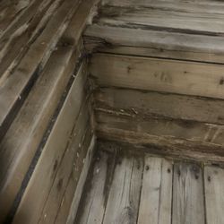
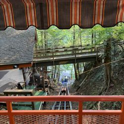
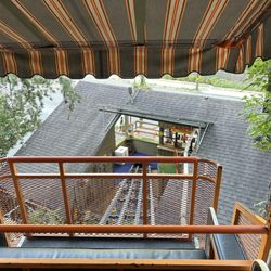
Mount LeConte Photos


You might also consider
More like Mount LeConte
Recommended Reviews - Mount LeConte
Start your review...

Reviews With Photos

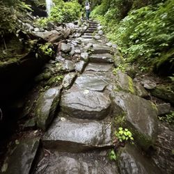
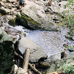
I would recommend Mount LeConte for an experienced hiker or if you are in shape endurance wise. It is tough and it is strenuous for a basic hiker like myself, especially coming from flat Michigan! It was the hardest hike I have done. There are plenty of views all the way up to the summit which is nice. Some of the rocks on the path can be slippery from the waterfalls so watch your step! It is a well traveled hike so there are people for sure. We went on a Monday and it was still pretty busy. Of course the higher the elevation the cooler it gets but it was cold up there in mid October! Pack your bag for all seasons! (Gloves, hat, layers). The lodge was a great addition to the hike and made it a unique stop. We ate our lunch here. There are restrooms and picnic tables to eat. The hike in total took us about 6 hours with plenty of rest breaks for water. Overall a great hike but hard and challenging at times.

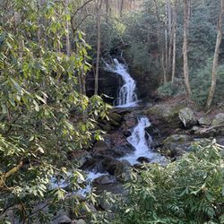
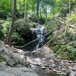
Going up is half the battle. What an emotional rollercoaster! Final numbers: 14 miles. 9.5 hours. Breathtaking views during hike towards the 6593 ft summit. Great memories. Wildlife. One 80-ft waterfall. Many many streams. Three slippery falls. Two scary, scary moments. Many smiles. A few tears and bad words. No phone signal. It was perfect. Recommend wearing hiking boots and appropriate hike gear! I wore tennis shoes and my feet were on fire and my shoes couldn't get good grip. If you're worried about bears, recommend purchasing an air horn. It was suggested as more useful over bear spray. Bring lots of snacks/some food. Our view at the summit was anticlimactic and covered with thick fog. Recommend not hiking up this gorgeous trail within 5-7 days of heavy rainfall.

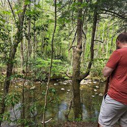
I fell in love with hiking. And with that, this place was a place I was referred to go and that the views were stunning. And were they right. The hike was 11 mile round trip, this is the one that is the Alum Cave Trail. It starts off slow, flat level, but about a mile or two in the elevation goes up and the views get more magnificent every mile in. I will be sure to come back to hike this several times a day as the views were gorgeous, the escape is nice, and soaking it all in and appreciating nature would be worth it.

This is the iconic Smoky Mountain National Park hike. I loved this challenging hike! It probably wouldn't have been as challenging on a sunny day with perfect weather. However, as fate would have it, my hike up to the summit was under very difficult (weather) conditions. There's more than one way up and we took the Alum Cave Trail. It started raining almost as soon as we left the trailhead. Normally, rain wouldn't bother me up a gentle hairpin trail. However, the switchbacks on this hike are far from gentle - most of the trail is steep and rocky (not rock-scrambling, it's still hiking but on a rocky surface - the smooth dirt trails at lower elevation became rocky ledges as we kept going up). It's easy to slip and fall off the mountain when the rocky ledge trail is wet and slippery (and it was pouring, so yes, the trail was extremely wet, slippery, and steep!). I was clinging to the thin metal handrail cables for dear life while hiking up the mountain very slowly and deliberately. About 45 minutes into the hike, it got super-foggy (now I know why they're called The Smokies - all that fog looks like smoke). I could barely see the other hikers, although I could hear them in front of me and behind me. To make things worse, we were told by the hike leader to "keep your bear spray handy because you won't know if a bear is around in this fog until it's less than a few feet from you." I figured if a bear got that close to me, I'd be toast with or without bear spray, so I didn't bother to take the bear spray out of my backpack. Over the next hour, the rain came down in torrents and my socks were soaking wet in spite of having all the right rain gear (water-proof hiking boots and water-proof hiking pants that covered the tops of my boots). Still, the torrential rain got into my boots somehow. The rain also got into my fleece jacket in spite of wearing a rain-proof jacket over my fleece. Then, with higher elevation, the rain became sleet and finally snow. If you think hiking up a steep, rocky surface in rain is slippery enough, try ice! Hiking on ice requires total focus! I was absolutely terrified once I experienced all that crazy ice on the trail. It was freezing cold. My feet in those damp socks were frozen. I couldn't let my freezing feet distract me while I was hiking on ice though. My hiking top under my fleece jacket was damp and I was freezing all over in spite of multiple warm layers (because of the rain that got inside my fleece and then inside my hiking top at lower elevation... and then all that water froze on my skin at higher elevation). Yet, I kept clinging on to the cables for dear life and carried on with the rest of the group. I didn't dare to let go of the cables. Letting go of the cables and changing my damp socks/clothes with all that ice around me seemed impossible...I didn't want to slow the group down by taking a "change of socks/clothes break" either. I was so relieved once we made it to the summit. Sadly, I couldn't see any of the amazing views from the top in all that fog. LeConte Lodge was a blessing at the summit because I could change into dry clothes and let all my damp clothes dry by the propane heaters (and thaw my freezing feet). LeConte Lodge was so warm and toasty, I wanted to stay there forever. The way down was in equally miserable weather - foggy and freezing cold (at higher elevation) and rainy (at lower elevation). I grabbed the cables for my safety, and worked my way down the mountain slowly. I felt much more confident on the way down and I enjoyed the views much more during the descent (after we passed the point where the fog clears up and you can actually see something). Going down was a lot less exhausting than going up (so we finished the descent relatively quickly) and I was euphoric once I'd completed the eleven-mile round trip under extremely challenging circumstances! Now, I want to return and hike up Mount LeConte all over again (but in late July or August...never again in the last week of March).


1 month ago


Mount LeConte is the highest mountain located within the Great Smoky Mountains National Park in Sevier County, Tennessee. At 6,593 ft. I have hiked around the mountains, and enjoyed, what each season's offers. Fall the leaves changing colors, snow in the winter, and Spring and summer the vegetation it is so alive. Good hikes, history, water falls, creeks, wild animals! Fireflies put on a nightly show in the summer! I must say there are so many people, it cannot be as relaxing, at least for me, I'm kind of a hermit. Nature is my sanctuary, it is home, I am comfortable when out in it! My native friends say it calls, and holds much knowledge. read more

The highest spot in the park and a nice 10+ mile hike from multiple trailheads in the park. We went up from both the Rainbow Falls and the Alum Cave trailheads and the Alum Cave trailhead was a bit less switch-backy and a bit more straightforward. The cliff top view at the very top (just a short hike up from the Le Conte lodge) was the best view that we saw all week and well worth the hike. Make sure you wear some shoes with ankle support or it'll be a long day as it'll be roughly 3-4 hours round trip. read more


4 years ago
I would recommend Mount LeConte for an experienced hiker or if you are in shape endurance wise. It is tough and it is strenuous for a basic hiker like myself, especially coming from flat Michigan! It was the hardest hike I have done. There are plenty of views all the way up to the summit which is nice. Some of the rocks on the path can be slippery from the waterfalls so watch your step! It is a well traveled hike so there are people for sure. We went on a Monday and it was still pretty busy. Of course the higher the elevation the cooler it gets but it was cold up there in mid October! Pack your bag for all seasons! (Gloves, hat, layers). The lodge was a great addition to the hike and made it a unique stop. We ate our lunch here. There are restrooms and picnic tables to eat. The hike in total took us about 6 hours with plenty of rest breaks for water. Overall a great hike but hard and challenging at times. read more


5 years ago
Going up is half the battle. What an emotional rollercoaster! Final numbers: 14 miles. 9.5 hours. Breathtaking views during hike towards the 6593 ft summit. Great memories. Wildlife. One 80-ft waterfall. Many many streams. Three slippery falls. Two scary, scary moments. Many smiles. A few tears and bad words. No phone signal. It was perfect. Recommend wearing hiking boots and appropriate hike gear! I wore tennis shoes and my feet were on fire and my shoes couldn't get good grip. If you're worried about bears, recommend purchasing an air horn. It was suggested as more useful over bear spray. Bring lots of snacks/some food. Our view at the summit was anticlimactic and covered with thick fog. Recommend not hiking up this gorgeous trail within 5-7 days of heavy rainfall. read more


I fell in love with hiking. And with that, this place was a place I was referred to go and that the views were stunning. And were they right. The hike was 11 mile round trip, this is the one that is the Alum Cave Trail. It starts off slow, flat level, but about a mile or two in the elevation goes up and the views get more magnificent every mile in. I will be sure to come back to hike this several times a day as the views were gorgeous, the escape is nice, and soaking it all in and appreciating nature would be worth it. read more

8 years ago
This is the iconic Smoky Mountain National Park hike. I loved this challenging hike! It probably wouldn't have been as challenging on a sunny day with perfect weather. However, as fate would have it, my hike up to the summit was under very difficult (weather) conditions. There's more than one way up and we took the Alum Cave Trail. It started raining almost as soon as we left the trailhead. Normally, rain wouldn't bother me up a gentle hairpin trail. However, the switchbacks on this hike are far from gentle - most of the trail is steep and rocky (not rock-scrambling, it's still hiking but on a rocky surface - the smooth dirt trails at lower elevation became rocky ledges as we kept going up). It's easy to slip and fall off the mountain when the rocky ledge trail is wet and slippery (and it was pouring, so yes, the trail was extremely wet, slippery, and steep!). I was clinging to the thin metal handrail cables for dear life while hiking up the mountain very slowly and deliberately. About 45 minutes into the hike, it got super-foggy (now I know why they're called The Smokies - all that fog looks like smoke). I could barely see the other hikers, although I could hear them in front of me and behind me. To make things worse, we were told by the hike leader to "keep your bear spray handy because you won't know if a bear is around in this fog until it's less than a few feet from you." I figured if a bear got that close to me, I'd be toast with or without bear spray, so I didn't bother to take the bear spray out of my backpack. Over the next hour, the rain came down in torrents and my socks were soaking wet in spite of having all the right rain gear (water-proof hiking boots and water-proof hiking pants that covered the tops of my boots). Still, the torrential rain got into my boots somehow. The rain also got into my fleece jacket in spite of wearing a rain-proof jacket over my fleece. Then, with higher elevation, the rain became sleet and finally snow. If you think hiking up a steep, rocky surface in rain is slippery enough, try ice! Hiking on ice requires total focus! I was absolutely terrified once I experienced all that crazy ice on the trail. It was freezing cold. My feet in those damp socks were frozen. I couldn't let my freezing feet distract me while I was hiking on ice though. My hiking top under my fleece jacket was damp and I was freezing all over in spite of multiple warm layers (because of the rain that got inside my fleece and then inside my hiking top at lower elevation... and then all that water froze on my skin at higher elevation). Yet, I kept clinging on to the cables for dear life and carried on with the rest of the group. I didn't dare to let go of the cables. Letting go of the cables and changing my damp socks/clothes with all that ice around me seemed impossible...I didn't want to slow the group down by taking a "change of socks/clothes break" either. I was so relieved once we made it to the summit. Sadly, I couldn't see any of the amazing views from the top in all that fog. LeConte Lodge was a blessing at the summit because I could change into dry clothes and let all my damp clothes dry by the propane heaters (and thaw my freezing feet). LeConte Lodge was so warm and toasty, I wanted to stay there forever. The way down was in equally miserable weather - foggy and freezing cold (at higher elevation) and rainy (at lower elevation). I grabbed the cables for my safety, and worked my way down the mountain slowly. I felt much more confident on the way down and I enjoyed the views much more during the descent (after we passed the point where the fog clears up and you can actually see something). Going down was a lot less exhausting than going up (so we finished the descent relatively quickly) and I was euphoric once I'd completed the eleven-mile round trip under extremely challenging circumstances! Now, I want to return and hike up Mount LeConte all over again (but in late July or August...never again in the last week of March). read more


7 years ago
Great hike! Gorgeous views and no hiking equipment needed. About 10miles one way. On top, there are a few houses where you can stay I guess and where you can get water and rest for a minute. read more


7 years ago
One word... BEAUTIFUL! If you are planning a hike this is the place to go. Already planning a hike with friends soon. Bring your camera! read more

7 years ago
12 years ago
10 years ago
More info about Mount LeConte
Gatlinburg, TN 37738
Directions
Hours
Outdoor Amenities
Ask the Community - Mount LeConte
Review Highlights - Mount LeConte


Why does Yelp recommend reviews?
1 review that is not currently recommended
The reviews below are not factored into the business's overall star rating.
7 years ago
Mount LeConte - hiking - Updated June 2026
Best of Gatlinburg
People found Mount LeConte by searching for…
Caves in Gatlinburg, Tennessee
Hiking Trails With Waterfalls in Gatlinburg, Tennessee
Scenic Overlook in Gatlinburg, Tennessee
Scenic View in Gatlinburg, Tennessee
Parks in Gatlinburg, Tennessee
Lookout Points in Gatlinburg, Tennessee
Waterfall in Gatlinburg, Tennessee
Walking Trails in Gatlinburg, Tennessee
Picnic Areas in Gatlinburg, Tennessee
Running Trails in Gatlinburg, Tennessee
Cave Tour in Gatlinburg, Tennessee
Easy Hikes in Gatlinburg, Tennessee
View Points in Gatlinburg, Tennessee
Beautiful Views in Gatlinburg, Tennessee
Things to Do in Gatlinburg, Tennessee
Creeks in Gatlinburg, Tennessee
Natural Hot Springs in Gatlinburg, Tennessee
Waterfalls and Swimming Holes in Gatlinburg, Tennessee
Tourist Attractions in Gatlinburg, Tennessee
Hiking Trails Kid Friendly in Gatlinburg, Tennessee
Off Road Trails in Gatlinburg, Tennessee
What to Do in Gatlinburg, Tennessee
Trending Searches in Gatlinburg, TN
Black Owned Nail Salons near Mount LeConte
Boat Rental near Mount LeConte
Cliff Jumping near Mount LeConte
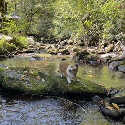
Dog Friendly Trails near Mount LeConte
Fishing Spots near Mount LeConte
Jet Ski Rental near Mount LeConte
Kayak Rental near Mount LeConte
Lakes & Ponds near Mount LeConte
Off Road Trails near Mount LeConte
Outdoor Activities near Mount LeConte
Public Pools near Mount LeConte
Public Shower near Mount LeConte
River Swimming near Mount LeConte
Rock Quarry near Mount LeConte
Scenic Night View near Mount LeConte
Scenic Overlook near Mount LeConte
Secluded Spots near Mount LeConte
Soccer Store near Mount LeConte
Strawberry Picking near Mount LeConte
Sunrise View near Mount LeConte
Swimming Holes near Mount LeConte
Swimming Lakes near Mount LeConte
U Pick Farms near Mount LeConte
Watch Sunset near Mount LeConte
Browse Articles
Browse Nearby
Browse Brands
Related Searches in Gatlinburg, TN
Affordable Kayak Rental Services in Gatlinburg, Tennessee
Best Fishing Locations and Guides in Gatlinburg, Tennessee
Best Nature Trails for Hiking in Gatlinburg, Tennessee
Best Places for Horseback Riding in Gatlinburg, Tennessee
Best Waterfalls and Swimming Holes in Gatlinburg, Tennessee
Check Out Off Road Trails in Gatlinburg, Tennessee
Discover Dog Friendly Trails to Explore in Gatlinburg, Tennessee
Discover Scenic Mountain Bike Trails Near Gatlinburg, Tennessee
Discover Scenic Waterfall Spots in Gatlinburg, Tennessee
Discover a Hiking Trail in Gatlinburg, Tennessee
Discover the Best Night Hike Trails in Gatlinburg, Tennessee
Discover the Best Running Track in Gatlinburg, Tennessee
Dog-Friendly Hikes With Dogs in Gatlinburg, Tennessee
Enjoy Camping Adventures Around Gatlinburg, Tennessee
Enjoy Exciting Mountain Biking Adventures in Gatlinburg, Tennessee
Enjoy Kayaking Adventures in Gatlinburg, Tennessee
Enjoy Tent Camping Spots Around Gatlinburg, Tennessee
Enjoy a Beautiful Waterfall Hike in Gatlinburg, Tennessee
Enjoy the Best Family Activities in Gatlinburg, Tennessee
Enjoy the Best Tubing Experiences in Gatlinburg, Tennessee
Enjoy the Best Walking Trails in Gatlinburg, Tennessee
Exciting Cliff Jumping Spots in Gatlinburg, Tennessee
Experience Thrilling White Water Rafting in Gatlinburg, Tennessee
Explore Beautiful Parks and Green Spaces in Gatlinburg, Tennessee
Explore Easy Hikes Perfect for All in Gatlinburg, Tennessee
Explore Fun Activities to Do in Gatlinburg, Tennessee
Explore Popular Campgrounds Near Gatlinburg, Tennessee
Explore the Best Boating Spots in Gatlinburg, Tennessee
Explore the Best Swimming Holes Around Gatlinburg, Tennessee
Explore the Best Trail Options in Gatlinburg, Tennessee
Family Friendly Hiking With Kids in Gatlinburg, Tennessee
Find Cozy Camping Cabins in Gatlinburg, Tennessee
Find Popular Ziplining Spots Around Gatlinburg, Tennessee
Find the Best Scenic View Locations in Gatlinburg, Tennessee
Hiking Trails With Waterfalls in Gatlinburg, Tennessee
Plan a Scenic Drive Route Near Gatlinburg, Tennessee
Popular Outdoor Activities to Try in Gatlinburg, Tennessee
Popular Picnic Spots to Visit in Gatlinburg, Tennessee
Popular Things to Do in Gatlinburg, Tennessee
Safe River Swimming Areas in Gatlinburg, Tennessee
Safe and Fun Parks for Kids in Gatlinburg, Tennessee
Top Climbing Spots and Gyms in Gatlinburg, Tennessee
Top Paddleboarding Activities in Gatlinburg, Tennessee
Top Places for Snorkeling in Gatlinburg, Tennessee
Top Running Trails to Explore in Gatlinburg, Tennessee
Top Swimming Lakes to Enjoy in Gatlinburg, Tennessee
Top Swimming Spots and Pools in Gatlinburg, Tennessee
Top Things to Do With Kids in Gatlinburg, Tennessee