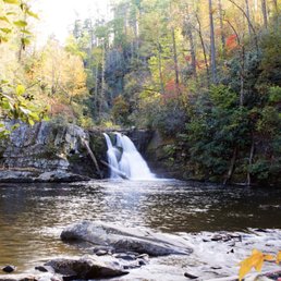
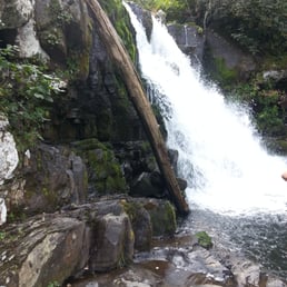
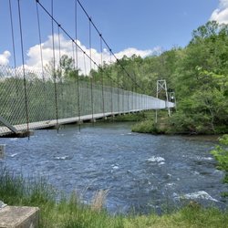
Abrams Falls Photos


You might also consider
More like Abrams Falls
Recommended Reviews - Abrams Falls
Start your review...

Reviews With Photos

Loved this hike! 5 mile round trip to falls through moderate up and down climbs. Some roots and rocks, a few log bridges and maybe a place or two with a slight scramble. If a hiker is in good shape, this is no problem. If not in great shape then can be challenging. That said, we passed by families with small children and more than a few grandparents. If planning the hike, trailhead is at the far eastern end of Cades Cove motor loop, which is a single lane, one way paved road. Can take a while to get in and out of during busy time as tourists drive slowly through the park and often pull on and off the road to see the sights.

The fam walked in the direction of Abrams but turned around early. I decided to run the segment which took a little over 40 minutes to make the 5 mile trek. Definitely not at challenging at Chimney Tops but fun and worth the adventure. If you are sure footed at any speed you won't have trouble navigating it either.


Great waterfalls.. A good 2.5 mile hike to and fro.. Shallow waters near the waterfall where you can get down.. The hike is pretty good and the trail is a bit rocky and jagged.. So please don't think of hiking it with flip flops.. you will regret it.. Have few bottles of water even though the trail is mostly covered by trees.. There are couple of pretty steep climbs.. It is also pretty adventurous with bridges to cross.. made with a single log of wood and only support on one side.. Pretty much every where you can hear the rush of the river...

This was our first hike on our trip to GSMNP and it was one of the best! We started out by leaving Gatlinburg at 8 since the drive to Cades Cove is about an hour. Once in Cades Cove, the speed limit lowers to about 20 and the road is one way. If you get stuck behind someone going slower, just be patient and take in the views! We finally pulled into the Abrams Falls parking area at about 9:45. The lot was only 1/4 full so we knew, we would have most of the trail to ourselves. While the trail is well maintained and easy to follow, there are tree roots and rocks that you need to watch for or you can twist an ankle quite easily. The trail to the falls and back is about 5.2 miles. It is rated as moderate and will take the average person 3-4 hours to hike. As with most other hikes in GSMNP, I would suggest good hiking shoes and hiking sticks/poles. There are just too many roots and wet rocks to compete with. Anyways, the hike to the falls is quite scenic as you are making your way along Abrams Creek and up the ridges. We finally reached the falls and they were amazing! Out of all the falls we saw that week, this was the biggest. There are plenty of rocks to sit and have a snack. You can make your way up to the falls and get some great pictures. We hung out for a good 20-30 minutes just enjoying the sounds. On the way back, we came across a bear!! He came down the side of the mountain and walked across the trail just 15 feet in front of us. We stood back, stayed quiet and let him pass. There is a lot of literature that tells you how to react to bears in the park. Obviously, the people who came up behind us as the bear was passing, had not read this literature. The started yelling and clapping at the bear. Ugghh. Be smart people, don't startle the bear!! Once we got back to the parking area around 12:45, it was packed! This is definitely a popular, beautiful trail and I would suggest getting there early if you want a quiet, enjoyable hike.

Cute hike and falls. The trail is up and down along the way so be prepared for mild elevation changes round trip. If you are an experienced hiker, this will be an easy hike. There were many little ones along the trail hiking with ease so feel comfortable bringing your kids. They will enjoy crossing the log bridges over water. Use caution at the end if you try to play in the water. It looked very murky and foamy and dirty from all the hikers food/spoils. I can't believe how many people dived into these waters. The falls are only about 20 feet high but overall this a cheery hike and a safe bet for all the family to enjoy at any experience level.

This was the most exhausting hike we ever did in gatlinburg. I under estimated the difficulty of this trail. It's listed as moderate but it's definitely more difficult than that. Please be aware of the rocky trails and the incline. You can easily trip over the rocks and the roots on the ground. The incline can make your heart pump 200 beats per minute. Take a moment to rest. Don't wear flip flops and make sure you bring plenty of water. I saw one old lady with a cane at the starting point. This trail is NOT as easy as you think. The only restroom is located at the starting point of the trail. So empty your bladders! Watch out for black bears. They do come up to the trails. The fall was pretty but by the time I made it, I was exhausted. I couldn't enjoy it because all I kept thinking was I had to hike my way back to the starting point :/
This is a solid 2 hour hike (round trip), and that's without kids. But it's well worth it once you get to the Falls! Absolutely beautiful view tucked away in Cades Cove. While we were hiking, we passed several people saying they had just seen a bear on the trail, so always be cautious in this area. Difficulty of the hike: moderate...definitely some inclined along the way but not too bad.

I like to refer to this waterfall as Little Niagara. If you decide to follow the 2.5 mile trail here, you'll see why. THE DRIVE Located inside the picturesque old pioneer village known as Cades Cove, this is one gem of a waterfall. The drive from the Sugarland Visitor Center to the Cades Cove entrance is about 40 minutes if there are no slowdowns in traffic. However, it is likely you will stop several times before making it to Cades Cove because of beautiful photo opportunities along the way. On a day after a heavy rainfall, sporadic waterfalls will appear in a variety of locations. We just can't get enough of these wonders of nature and will stop often. A great spot to pull over is where Little River Road crosses the river (about half way to Cades Cove). Look for the parking area and overlook to the left just before crossing the bridge. The river elbows at the base of the bridge creating a mighty rushing sound as all it's power flows over the drop in elevation and creates a cool whirlpool. Truly spectacular. The road will veer left and change names to Laurel Creek Road, which will take you directly into Cades Cove. Once inside the Cove, you will circle the 11 mile loop as your eyes take in a wonderful flat valley full of deer that absolutely seem to know they are protected. They often stroll in front of your car giving you a look that seems to say "Hit me, I dare you!" LOL! Marvel as mountains seem to suddenly rise up directly from prairies without warning. The mountains here are tall enough to have snowcaps in the Winter and early Spring. Almost exactly half way through the loop you will see a turn-off for Abram falls on the right along a gravel road. Parking is plentiful, but can get crowded in the popular seasons. THE TRAIL Of all the trails we've hiked in the Smokies, this is one feels like you are walking along the lines of an EKG chart. One moment you are walking directly next to the river, and the next you are 120 feet above it, and then back down again. It's rated as moderate, but I honestly don't know where they get these ratings, because this trail will wear you out! I had the pleasure of carrying my (then) 7 year old the full 2.5 mile distance back from the falls because his "legs stopped working." I was friggin' exhausted, but my wife thought my effort was heroic and sexy and ... well... that alone had it's benefits. Ka-Chow!!! The trail leads you over 3 log bridges and at it's highest point crosses you over the jagged peak of a mountain ridge so high up you don't hear the rush of the river anymore. I'd say at this point you are a little over half way there. Here is a great opportunity to pick up lots of small flat stones that look perfect to make arrows, or at least pretend they were once arrowheads of Indians. SIDE NOTE: Little boys get a huge kick out of this section of the hike with a little imagination encouragement. THE FALLS Once you arrive, you will know it. The falls are glorious, but because of the curve of the trail, they remain hidden from your view until you are only 50 yards away... but what a sight! The waterfall and creek were named after a Cherokee Chief whose village once stood several miles downstream. It is HIGHLY DISCOURAGED to swim here or climb the wall of stone nearby to reach the top of the falls. Yet that never seems to stop large groups of families from doing just that. I must admit I share in some of the guilt of being a rule breaker, but we have been fortunate enough not to turn into a statistic. I could honestly spent the entire day camped out along the rocky shore and we often do. Some sections of the water near the shore are calm pools that have little to no current and are moderately safe (in my opinion). But it is best to heed the warnings, because several deaths have happened here. BE SURE to backpack in a lunch, especially if you have little ones in tow. It is a very tiring walk and many, many people enjoy picnicking here once they've arrived. Just remember to backpack out your trash. You do not want to encourage Black Bears to come here looking for scraps of food. VIDEO I love this families video of their hike to the falls. As a dad, it inspires me to take up videography: http://www.youtube.com/watch?v=rfLl8ARfr-s The ridge I described in my review where you cross over from one side of the mountain to the other is at about the 2:58 minute mark. THE VERDICT Abram Falls has the highest volume of water flow of any waterfall in the GSM Nat'l Park, which easily makes it one of my favorites. The drive to get here and all the things to see once you arrive in Cades Cove makes it my BEST recommendation for outdoor activities when visiting the Smokies. You'll want to come back here again and again. --------------- - - - - - Trail Location: Cades Cove Roundtrip Length: 5.0 Miles Total Elevation Gain: 340 feet Highest Elevation: 1710 feet Trail Difficulty Rating: 5.68 (moderate) Yelp100 [34]
Came on this hike during our drive through Cade's cove. It was the most difficult hike we did during our stay in Gatlinburg. Make sure you wear good shoes, bring water, and watch your step. The trails can get pretty rocky. I saw one girl attempting to do it in flip flops. Don't do that. It took us about two hours to get there and two hours to get back. It was beautiful and worth the hike, just be prepared.

Hike was great. It is not for everybody it is alot of up hill terrain and it is 2.5 miles there and 2.5 miles back. Hike took about 3.5 hrs for the both of us. Some make sure you start early enough so it doesn't get dark on you. Well worth the hike but bring water and a snack because it will take a bit. read more


8 months ago
This is an absolutely gorgeous trail even in November we had a sunny day and stunning views along the trail. read more

1 year ago
Loved this hike! 5 mile round trip to falls through moderate up and down climbs. Some roots and rocks, a few log bridges and maybe a place or two with a slight scramble. If a hiker is in good shape, this is no problem. If not in great shape then can be challenging. That said, we passed by families with small children and more than a few grandparents. If planning the hike, trailhead is at the far eastern end of Cades Cove motor loop, which is a single lane, one way paved road. Can take a while to get in and out of during busy time as tourists drive slowly through the park and often pull on and off the road to see the sights. read more

6 years ago
The fam walked in the direction of Abrams but turned around early. I decided to run the segment which took a little over 40 minutes to make the 5 mile trek. Definitely not at challenging at Chimney Tops but fun and worth the adventure. If you are sure footed at any speed you won't have trouble navigating it either. read more


4 years ago
An absolutely beautiful hike! Totally worth the time. Recommend getting there early to avoid the crowds. A more moderate hike that has a good mix of incline and decline. read more

5 years ago
Go early!! Took about 3-3.5 hours round trip. We sat at the waterfall for a bit and had a snack. Lots of traffic heading in when we were hiking out around 1. Take water for your group. Trail was well marked and lots of up and downhill but everyone was able to do it without much trouble. read more


5 years ago
Beautiful!!! Definitely worth the walk. Legs are definitely sore but we're not big hikers. It has sooo many awesome views and big enough that you're not walking all over people. read more


Great waterfalls.. A good 2.5 mile hike to and fro.. Shallow waters near the waterfall where you can get down.. The hike is pretty good and the trail is a bit rocky and jagged.. So please don't think of hiking it with flip flops.. you will regret it.. Have few bottles of water even though the trail is mostly covered by trees.. There are couple of pretty steep climbs.. It is also pretty adventurous with bridges to cross.. made with a single log of wood and only support on one side.. Pretty much every where you can hear the rush of the river... read more


10 years ago
This was our first hike on our trip to GSMNP and it was one of the best! We started out by leaving Gatlinburg at 8 since the drive to Cades Cove is about an hour. Once in Cades Cove, the speed limit lowers to about 20 and the road is one way. If you get stuck behind someone going slower, just be patient and take in the views! We finally pulled into the Abrams Falls parking area at about 9:45. The lot was only 1/4 full so we knew, we would have most of the trail to ourselves. While the trail is well maintained and easy to follow, there are tree roots and rocks that you need to watch for or you can twist an ankle quite easily. The trail to the falls and back is about 5.2 miles. It is rated as moderate and will take the average person 3-4 hours to hike. As with most other hikes in GSMNP, I would suggest good hiking shoes and hiking sticks/poles. There are just too many roots and wet rocks to compete with. Anyways, the hike to the falls is quite scenic as you are making your way along Abrams Creek and up the ridges. We finally reached the falls and they were amazing! Out of all the falls we saw that week, this was the biggest. There are plenty of rocks to sit and have a snack. You can make your way up to the falls and get some great pictures. We hung out for a good 20-30 minutes just enjoying the sounds. On the way back, we came across a bear!! He came down the side of the mountain and walked across the trail just 15 feet in front of us. We stood back, stayed quiet and let him pass. There is a lot of literature that tells you how to react to bears in the park. Obviously, the people who came up behind us as the bear was passing, had not read this literature. The started yelling and clapping at the bear. Ugghh. Be smart people, don't startle the bear!! Once we got back to the parking area around 12:45, it was packed! This is definitely a popular, beautiful trail and I would suggest getting there early if you want a quiet, enjoyable hike. read more


11 years ago
Cute hike and falls. The trail is up and down along the way so be prepared for mild elevation changes round trip. If you are an experienced hiker, this will be an easy hike. There were many little ones along the trail hiking with ease so feel comfortable bringing your kids. They will enjoy crossing the log bridges over water. Use caution at the end if you try to play in the water. It looked very murky and foamy and dirty from all the hikers food/spoils. I can't believe how many people dived into these waters. The falls are only about 20 feet high but overall this a cheery hike and a safe bet for all the family to enjoy at any experience level. read more


12 years ago
This was the most exhausting hike we ever did in gatlinburg. I under estimated the difficulty of this trail. It's listed as moderate but it's definitely more difficult than that. Please be aware of the rocky trails and the incline. You can easily trip over the rocks and the roots on the ground. The incline can make your heart pump 200 beats per minute. Take a moment to rest. Don't wear flip flops and make sure you bring plenty of water. I saw one old lady with a cane at the starting point. This trail is NOT as easy as you think. The only restroom is located at the starting point of the trail. So empty your bladders! Watch out for black bears. They do come up to the trails. The fall was pretty but by the time I made it, I was exhausted. I couldn't enjoy it because all I kept thinking was I had to hike my way back to the starting point :/ read more

This is a solid 2 hour hike (round trip), and that's without kids. But it's well worth it once you get to the Falls! Absolutely beautiful view tucked away in Cades Cove. While we were hiking, we passed several people saying they had just seen a bear on the trail, so always be cautious in this area. Difficulty of the hike: moderate...definitely some inclined along the way but not too bad. read more

13 years ago
I like to refer to this waterfall as Little Niagara. If you decide to follow the 2.5 mile trail here, you'll see why. THE DRIVE Located inside the picturesque old pioneer village known as Cades Cove, this is one gem of a waterfall. The drive from the Sugarland Visitor Center to the Cades Cove entrance is about 40 minutes if there are no slowdowns in traffic. However, it is likely you will stop several times before making it to Cades Cove because of beautiful photo opportunities along the way. On a day after a heavy rainfall, sporadic waterfalls will appear in a variety of locations. We just can't get enough of these wonders of nature and will stop often. A great spot to pull over is where Little River Road crosses the river (about half way to Cades Cove). Look for the parking area and overlook to the left just before crossing the bridge. The river elbows at the base of the bridge creating a mighty rushing sound as all it's power flows over the drop in elevation and creates a cool whirlpool. Truly spectacular. The road will veer left and change names to Laurel Creek Road, which will take you directly into Cades Cove. Once inside the Cove, you will circle the 11 mile loop as your eyes take in a wonderful flat valley full of deer that absolutely seem to know they are protected. They often stroll in front of your car giving you a look that seems to say "Hit me, I dare you!" LOL! Marvel as mountains seem to suddenly rise up directly from prairies without warning. The mountains here are tall enough to have snowcaps in the Winter and early Spring. Almost exactly half way through the loop you will see a turn-off for Abram falls on the right along a gravel road. Parking is plentiful, but can get crowded in the popular seasons. THE TRAIL Of all the trails we've hiked in the Smokies, this is one feels like you are walking along the lines of an EKG chart. One moment you are walking directly next to the river, and the next you are 120 feet above it, and then back down again. It's rated as moderate, but I honestly don't know where they get these ratings, because this trail will wear you out! I had the pleasure of carrying my (then) 7 year old the full 2.5 mile distance back from the falls because his "legs stopped working." I was friggin' exhausted, but my wife thought my effort was heroic and sexy and ... well... that alone had it's benefits. Ka-Chow!!! The trail leads you over 3 log bridges and at it's highest point crosses you over the jagged peak of a mountain ridge so high up you don't hear the rush of the river anymore. I'd say at this point you are a little over half way there. Here is a great opportunity to pick up lots of small flat stones that look perfect to make arrows, or at least pretend they were once arrowheads of Indians. SIDE NOTE: Little boys get a huge kick out of this section of the hike with a little imagination encouragement. THE FALLS Once you arrive, you will know it. The falls are glorious, but because of the curve of the trail, they remain hidden from your view until you are only 50 yards away... but what a sight! The waterfall and creek were named after a Cherokee Chief whose village once stood several miles downstream. It is HIGHLY DISCOURAGED to swim here or climb the wall of stone nearby to reach the top of the falls. Yet that never seems to stop large groups of families from doing just that. I must admit I share in some of the guilt of being a rule breaker, but we have been fortunate enough not to turn into a statistic. I could honestly spent the entire day camped out along the rocky shore and we often do. Some sections of the water near the shore are calm pools that have little to no current and are moderately safe (in my opinion). But it is best to heed the warnings, because several deaths have happened here. BE SURE to backpack in a lunch, especially if you have little ones in tow. It is a very tiring walk and many, many people enjoy picnicking here once they've arrived. Just remember to backpack out your trash. You do not want to encourage Black Bears to come here looking for scraps of food. VIDEO I love this families video of their hike to the falls. As a dad, it inspires me to take up videography: http://www.youtube.com/watch?v=rfLl8ARfr-s The ridge I described in my review where you cross over from one side of the mountain to the other is at about the 2:58 minute mark. THE VERDICT Abram Falls has the highest volume of water flow of any waterfall in the GSM Nat'l Park, which easily makes it one of my favorites. The drive to get here and all the things to see once you arrive in Cades Cove makes it my BEST recommendation for outdoor activities when visiting the Smokies. You'll want to come back here again and again. --------------- - - - - - Trail Location: Cades Cove Roundtrip Length: 5.0 Miles Total Elevation Gain: 340 feet Highest Elevation: 1710 feet Trail Difficulty Rating: 5.68 (moderate) Yelp100 [34] read more


 - Hiking Near Me - Townsend, Tennessee")
12 years ago
Came on this hike during our drive through Cade's cove. It was the most difficult hike we did during our stay in Gatlinburg. Make sure you wear good shoes, bring water, and watch your step. The trails can get pretty rocky. I saw one girl attempting to do it in flip flops. Don't do that. It took us about two hours to get there and two hours to get back. It was beautiful and worth the hike, just be prepared. read more

13 years ago
10 years ago
Listen to the Park Rangers at the entrance. TAKE WATER. TAKE A SNACK. I thought oh 2 1/2 miles is no big deal. I work out 5 days a week and Abram's Falls hike whipped me. It was worth the pain. The falls are beautiful and the water is clear and cold. I was too scared to swim but there were kids and adults all swimming and jumping from the rocks. The hike back was the absolute worst part. But over all it was time well spent. TAKE WATER. read more


10 years ago
10 years ago
11 years ago
11 years ago
More info about Abrams Falls
Ask the Community - Abrams Falls
Review Highlights - Abrams Falls


Why does Yelp recommend reviews?
1 review that is not currently recommended
The reviews below are not factored into the business's overall star rating.
9 years ago
Abrams Falls - hiking - Updated June 2026
Best of Townsend
People found Abrams Falls by searching for…
Swimming Holes in Townsend, Tennessee
Hiking Trails With Waterfalls in Townsend, Tennessee
Things to Do in Townsend, Tennessee
Scenic View in Townsend, Tennessee
Places to Take Pictures in Townsend, Tennessee
Off Road Trails in Townsend, Tennessee
Scenic Drive in Townsend, Tennessee
Scenic Overlook in Townsend, Tennessee
Waterfall in Townsend, Tennessee
River Swimming in Townsend, Tennessee
Walking Trails in Townsend, Tennessee
Photo Spots in Townsend, Tennessee
Secret Spots in Townsend, Tennessee
Dinosaur Park in Townsend, Tennessee
Natural Hot Springs in Townsend, Tennessee
Running Trails in Townsend, Tennessee
Rock Quarry in Townsend, Tennessee
Swimming Lakes in Townsend, Tennessee
Easy Hikes in Townsend, Tennessee
Parks for Kids in Townsend, Tennessee
Trending Searches in Townsend, TN
Cliff Jumping near Abrams Falls
Dog Friendly Trails near Abrams Falls
Fishing Spots near Abrams Falls
Jet Ski Rental near Abrams Falls
Kayak Rental near Abrams Falls
Lakes & Ponds near Abrams Falls
Off Road Trails near Abrams Falls
Outdoor Activities near Abrams Falls
Public Pools near Abrams Falls
Public Shower near Abrams Falls
River Swimming near Abrams Falls
Scenic Night View near Abrams Falls
Scenic Overlook near Abrams Falls
Secluded Spots near Abrams Falls
Soccer Store near Abrams Falls
Strawberry Picking near Abrams Falls
Sunrise View near Abrams Falls
Swimming Holes near Abrams Falls
Swimming Lakes near Abrams Falls
U Pick Farms near Abrams Falls
Browse Brands
Related Searches in Townsend, TN
Affordable Kayak Rental Services in Townsend, Tennessee
Best Fishing Locations and Guides in Townsend, Tennessee
Best Nature Trails for Hiking in Townsend, Tennessee
Best Places for Horseback Riding in Townsend, Tennessee
Best Waterfalls and Swimming Holes in Townsend, Tennessee
Check Out Off Road Trails in Townsend, Tennessee
Discover Dog Friendly Trails to Explore in Townsend, Tennessee
Discover Kid Friendly Hiking Trails in Townsend, Tennessee
Discover Scenic Mountain Bike Trails Near Townsend, Tennessee
Discover Scenic Waterfall Spots in Townsend, Tennessee
Discover a Hiking Trail in Townsend, Tennessee
Discover the Best Night Hike Trails in Townsend, Tennessee
Discover the Best Running Track in Townsend, Tennessee
Dog-Friendly Hikes With Dogs in Townsend, Tennessee
Enjoy Camping Adventures Around Townsend, Tennessee
Enjoy Exciting Mountain Biking Adventures in Townsend, Tennessee
Enjoy Kayaking Adventures in Townsend, Tennessee
Enjoy Tent Camping Spots Around Townsend, Tennessee
Enjoy a Beautiful Waterfall Hike in Townsend, Tennessee
Enjoy the Best Tubing Experiences in Townsend, Tennessee
Enjoy the Best Walking Trails in Townsend, Tennessee
Exciting Cliff Jumping Spots in Townsend, Tennessee
Experience Thrilling White Water Rafting in Townsend, Tennessee
Explore Beautiful Parks and Green Spaces in Townsend, Tennessee
Explore Easy Hikes Perfect for All in Townsend, Tennessee
Explore Fun Activities to Do in Townsend, Tennessee
Explore Popular Campgrounds Near Townsend, Tennessee
Explore the Best Boating Spots in Townsend, Tennessee
Explore the Best Swimming Holes Around Townsend, Tennessee
Explore the Best Trail Options in Townsend, Tennessee
Family Friendly Hiking With Kids in Townsend, Tennessee
Find Beautiful Views in Townsend, Tennessee
Find Cozy Camping Cabins in Townsend, Tennessee
Find Popular Ziplining Spots Around Townsend, Tennessee
Find the Best Scenic View Locations in Townsend, Tennessee
Hiking Trails With Waterfalls in Townsend, Tennessee
Off Leash Dog Hiking Trails in Townsend, Tennessee
Plan a Scenic Drive Route Near Townsend, Tennessee
Popular Outdoor Activities to Try in Townsend, Tennessee
Popular Picnic Spots to Visit in Townsend, Tennessee
Safe River Swimming Areas in Townsend, Tennessee
Safe and Fun Parks for Kids in Townsend, Tennessee
Top Climbing Spots and Gyms in Townsend, Tennessee
Top Paddleboarding Activities in Townsend, Tennessee
Top Places for Snorkeling in Townsend, Tennessee
Top Swimming Lakes to Enjoy in Townsend, Tennessee
Top Swimming Spots and Pools in Townsend, Tennessee
Top Things to Do With Kids in Townsend, Tennessee