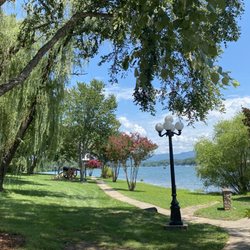
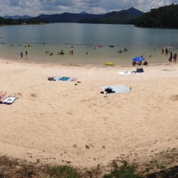
High Shoals Falls Loop Trail Photos


More like High Shoals Falls Loop Trail
Recommended Reviews - High Shoals Falls Loop Trail
Start your review...

Reviews With Photos

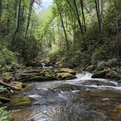
Super fun hike to some of the best waterfalls in the area. If you are making the hike in the summer bring a bathing suit. The water is a great way to cool off for the hike back up to the parking area. If you go in the winter and time it right the ice that forms during extended cold weather is really neat to see.

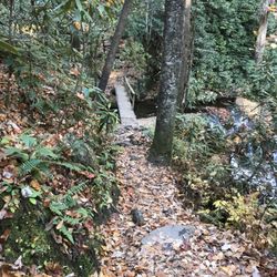
WARNING the bridge to this fall is out. We had to cross over a fallen tree and some make shift boards. You will have to cross through the water or have enough balance to cross the log. My pooch would not cross on the log so I fashioned his harness into a carrying loop and carried him like suitcase then switched to a cradle carry. Be sure to visit both falls if you can make the hike. Both falls were not listed in the guide book we had and we missed one of them. The trip back from this fall is very steep and if you are not a hiker or do cardio the trip back to the car will be tough.

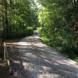
first, great hike. little hard to get to. the drive in was met with a small river pool that hopefully you can drive through, it's not bad but some people parked before that...and they hiked 1.3 miles up (and back down) in addition to the actual hike. most people drive through the pool, including us. once past the small pool, drive up and there is a small parking area near the start of the hike. likely it'll be full and you'll have to park on the side of the road. the road is small and gravely and uphill but not terrible, definitely not the best. lots of bumps etc. it's just in the smaller side so drive slow. the hike is mostly downhill or flat on the way there. we only saw 1/2 waterfalls but high shoals falls was beautiful! the deck comes up kinda close so it's nice. it's about 1.1-1.2 miles one way. don't get lost as there are a couple of area with random paths. it's all down hill at first or flat. then you'll get to campsite and bridge and you keeps going. another 15-20 from the campsite ( or longer? if you walk a little slow, or less? if you're a speed demon) and you're there. falls are lovely! the hike back isn't that bad, it may feel super downhill going there but it's not that bad going up. yes, it's uphill but there isn't a crazy steep grade and if you take it slow, it's fine. take breaks if you need too. nice family hike or with friends. about 2.4 round and maybe more if you take other routes or go to the other waterfall. some small muddy area on the trail, nothing crazy when we went. the bugs are starting to come out slowly. no restrooms that we saw. overall loved the hike. it's very pretty. careful driving there and back. i wouldn't do the drive at night unless you know the area. beautiful nature hike that we will do again!

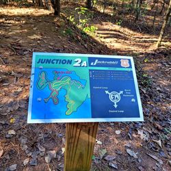
Looking for an impressive waterfall for photo opportunities or simply to enjoy? High Shoals should be high on your list of Georgia waterfall destinations. There are two named waterfalls along this trail, Blue Hole Falls and High Shoals Falls. However, there is a third waterfall above Blue Hole Falls that didn't have a name. [ DIRECTIONS ] We are fans of the navigation app called WAZE, but as do all navigation apps, it can sometimes get it wrong. We typed in High Shoals Falls and it lead us to Moody Hollow. This is NOT the official location of the parking area (which is actually on Indian Grave Gap Road), and the locals have all kinds of signs up warning you not to park on their PRIVATE property. No signs indicated any sort of trailhead, so we turned back discouraged. However, to our good fortune we ran across a local woman out for her daily walk and inquired how to find the correct parking area for the falls. She informed us that there IS a trail right off Moody Hollow and invited us to park in a grassy area near the river so that we could walk with her to the trailhead. She also said this trail is super quick and far shorter to the falls than the one from the official parking area. She was 100% correct. [ THE EXPERIENCE ] What I didn't like about the trails is they are not marked. Although we found High Shoals Falls by accident, we completely missed Blue Hole. We almost walked all the way to the official parking lot had it not been for an older gentleman that told us the falls were back in the direction we had just came. "I just came from that way and didn't see another waterfall" I argued. "I've been coming here for two decades" he said, "and the waterfalls are back this way" as he pointed behind me. "As a matter of fact, there is a THIRD waterfall, not just the two you've heard about." So I trusted his word and sure enough, he was right. Thank goodness for friendly locals! - - - - - If you are coming from the parking area, please know the bridge over the main river is out! You must cross the river via strategically placed tree trunks to the left of the bridge. As you continue downhill, you will see several spur trails branch off to your left. The first will take you to the third waterfall above blue hole. The one that has a set of timber steps is the one that will lead you to Blue Hole Falls. The next spur trail downhill will take you to the top of High Shoals Falls. Finally, the one after that (along the main trail) will lead you to the base of High Shoals Fall where there is a wooden viewing platform. High Shoals Falls is the larger of the three and absolutely breathtaking when the water flow is high. I couldn't find any information about the height of it, but my guess is it is between 90-115 feet tall. Blue Hole is approximately 16 feet tall with a deep swimming hole approx. the size of a neighborhood pool. We actually witnesses a man jump in to swim, despite it being a frigidly cold day. The third waterfall above Blue Hole is about 9 feet tall. The trail from the parking area is ALL DOWNHILL, so you will definitely get a serious calorie burn on the return trip back. Where we parked was much easier on the legs, but because of all the warning signs I wouldn't recommend it. The local women told me the warning signs are only scare tactics and really can't be enforced, unless you actually do park on someone's property... but the trail is for everyone. Still, I wouldn't advise it. [ FINAL THOUGHTS ] Easily one of the most attractive and photogenic waterfalls in Georgia. You won't be disappointed IF you come AFTER a few days of heavy rainfall in the area. My top favorite photo-friendly waterfalls in Georgia are: SHORT HIKE * Lula Falls * Toccoa Falls * Dicks Creek (Suches, GA) * Helton Creek Falls * Minnehaha Falls * Mud Creek Falls LONG HIKE * Panther Creek Falls * Emery Creek Falls * Jack's River Falls Enjoy, and be sure to check out nearby Bell Mountain and Brasstown Bald. 2018/104

This is a BEAUTIFUL and relaxing walk toward some picturesque falls. Thanks to the drought and impending North Georgia forest fires, the falls didn't have that view we were expecting or hoping for. However, the brisk weather was mild and perfect for a fall day's walk. The trail is an easy trek, with soft footfalls on heavily trodden paths. The trail itself is straightforward, with some pretty clear trail markings to keep you going the right direction. Driving to the trailhead was rough. For your own safety, don't drive a wimpy car that can't handle a rougher terrain. Once we hiked to the falls, we snapped a group picture in front of the water before wandering off the viewing deck to eat our packed lunches atop some of the flatter rocks in front of the falls. The view is beautiful and the environment is peaceful. If you're in North Georgia, this is definitely worth a stop!

Two waterfalls!! Hiawasee is becoming one of my favorite North Georgia cities. Not only does it have the beautiful Bell Mountain, of of my favorite 360 views https://www.yelp.com/biz/bell-mountain-hiawassee but it also has Blue Hole and High Shoals Falls! Usually when I go to waterfalls or any hiking trips up north, I do a lot of research cause I want to make sure the right vehicle will be used. I have a Toyota Camry so I'm always hesitate to go hiking without my husband. We either take our SUV or truck to go hiking if it requires non paved or thin roads. He most likely will come with me. When I go to any state parks, we could take my city car as he calls it. The trail is off the Unicoi Turnpike and Indian Grave Gap Rd. The road to turn is a sharp right so if you're not paying attention, you could miss it. You will cross a creek and those traveling in smaller cars will have to be careful. I saw several YouTube videos warning me about it too. Come early for parking. Some people camp out. Some may block the trailhead. Once you see the main bridge, you will have two more bridges, but smaller, after that to hike towards the bottom to get to Blue Shoals Falls first, then after that, come back up and go to the other trail for High Shoals Trail. When we went, the first bridge, a tree had fallen on the bridge and we had to cross the cold creek. We saw some handmade crossings and went that way. Be careful. will be slippery. Note - you're going downhill but elevation isn't that bad but get ready to go back up. The trail to both is less than 3 miles. It's not that bad. If you're not in shape, could be a little strenuous. Blue Shoals Falls is a swimming hole. I've seen pictures and videos where people have dived into it. There will be photographers doing photo shoots as well. High Shoals Trail is taller and more beautiful. You could go close to the falls too but no swimming hole. Overall, beautiful! 71/2018

This was a great way to spend a few hours outside, hiking and even swimming. There are also several places to camp. When you go, there is a long gravel road, and at one point you have to cross the creek in your car. I crossed it in a Honda Accord, but it has not been raining lately. If it has been fairly rainy lately this may be an issue. May not, but a warning. Also while driving up, you may see some cars parked, that the beginning of the trail. The direct address i had, wanted me to go further up. I never did so I'm not sure exactly where it would have taken us. The path is pretty straight forward once you find it wear good shoes. A lot of roots and rocks. And pick up any trash you bring!


2 years ago
4 years ago
This is my GOTO for any season ... doing this hike in summer is just extraordinary. We did this hike with our dog , it's medium with lil elevations . I love the swimming hole here , not so deep for you n ur fur babies . Mine is a 78 pound lab mix who loves water . Most of the trail is covered with trees so even on a hot summer day you can totally attempt this . read more


3 years ago
Super fun hike to some of the best waterfalls in the area. If you are making the hike in the summer bring a bathing suit. The water is a great way to cool off for the hike back up to the parking area. If you go in the winter and time it right the ice that forms during extended cold weather is really neat to see. read more
7 years ago
WARNING the bridge to this fall is out. We had to cross over a fallen tree and some make shift boards. You will have to cross through the water or have enough balance to cross the log. My pooch would not cross on the log so I fashioned his harness into a carrying loop and carried him like suitcase then switched to a cradle carry. Be sure to visit both falls if you can make the hike. Both falls were not listed in the guide book we had and we missed one of them. The trip back from this fall is very steep and if you are not a hiker or do cardio the trip back to the car will be tough. read more


first, great hike. little hard to get to. the drive in was met with a small river pool that hopefully you can drive through, it's not bad but some people parked before that...and they hiked 1.3 miles up (and back down) in addition to the actual hike. most people drive through the pool, including us. once past the small pool, drive up and there is a small parking area near the start of the hike. likely it'll be full and you'll have to park on the side of the road. the road is small and gravely and uphill but not terrible, definitely not the best. lots of bumps etc. it's just in the smaller side so drive slow. the hike is mostly downhill or flat on the way there. we only saw 1/2 waterfalls but high shoals falls was beautiful! the deck comes up kinda close so it's nice. it's about 1.1-1.2 miles one way. don't get lost as there are a couple of area with random paths. it's all down hill at first or flat. then you'll get to campsite and bridge and you keeps going. another 15-20 from the campsite ( or longer? if you walk a little slow, or less? if you're a speed demon) and you're there. falls are lovely! the hike back isn't that bad, it may feel super downhill going there but it's not that bad going up. yes, it's uphill but there isn't a crazy steep grade and if you take it slow, it's fine. take breaks if you need too. nice family hike or with friends. about 2.4 round and maybe more if you take other routes or go to the other waterfall. some small muddy area on the trail, nothing crazy when we went. the bugs are starting to come out slowly. no restrooms that we saw. overall loved the hike. it's very pretty. careful driving there and back. i wouldn't do the drive at night unless you know the area. beautiful nature hike that we will do again! read more


3 years ago
8 years ago
Looking for an impressive waterfall for photo opportunities or simply to enjoy? High Shoals should be high on your list of Georgia waterfall destinations. There are two named waterfalls along this trail, Blue Hole Falls and High Shoals Falls. However, there is a third waterfall above Blue Hole Falls that didn't have a name. [ DIRECTIONS ] We are fans of the navigation app called WAZE, but as do all navigation apps, it can sometimes get it wrong. We typed in High Shoals Falls and it lead us to Moody Hollow. This is NOT the official location of the parking area (which is actually on Indian Grave Gap Road), and the locals have all kinds of signs up warning you not to park on their PRIVATE property. No signs indicated any sort of trailhead, so we turned back discouraged. However, to our good fortune we ran across a local woman out for her daily walk and inquired how to find the correct parking area for the falls. She informed us that there IS a trail right off Moody Hollow and invited us to park in a grassy area near the river so that we could walk with her to the trailhead. She also said this trail is super quick and far shorter to the falls than the one from the official parking area. She was 100% correct. [ THE EXPERIENCE ] What I didn't like about the trails is they are not marked. Although we found High Shoals Falls by accident, we completely missed Blue Hole. We almost walked all the way to the official parking lot had it not been for an older gentleman that told us the falls were back in the direction we had just came. "I just came from that way and didn't see another waterfall" I argued. "I've been coming here for two decades" he said, "and the waterfalls are back this way" as he pointed behind me. "As a matter of fact, there is a THIRD waterfall, not just the two you've heard about." So I trusted his word and sure enough, he was right. Thank goodness for friendly locals! - - - - - If you are coming from the parking area, please know the bridge over the main river is out! You must cross the river via strategically placed tree trunks to the left of the bridge. As you continue downhill, you will see several spur trails branch off to your left. The first will take you to the third waterfall above blue hole. The one that has a set of timber steps is the one that will lead you to Blue Hole Falls. The next spur trail downhill will take you to the top of High Shoals Falls. Finally, the one after that (along the main trail) will lead you to the base of High Shoals Fall where there is a wooden viewing platform. High Shoals Falls is the larger of the three and absolutely breathtaking when the water flow is high. I couldn't find any information about the height of it, but my guess is it is between 90-115 feet tall. Blue Hole is approximately 16 feet tall with a deep swimming hole approx. the size of a neighborhood pool. We actually witnesses a man jump in to swim, despite it being a frigidly cold day. The third waterfall above Blue Hole is about 9 feet tall. The trail from the parking area is ALL DOWNHILL, so you will definitely get a serious calorie burn on the return trip back. Where we parked was much easier on the legs, but because of all the warning signs I wouldn't recommend it. The local women told me the warning signs are only scare tactics and really can't be enforced, unless you actually do park on someone's property... but the trail is for everyone. Still, I wouldn't advise it. [ FINAL THOUGHTS ] Easily one of the most attractive and photogenic waterfalls in Georgia. You won't be disappointed IF you come AFTER a few days of heavy rainfall in the area. My top favorite photo-friendly waterfalls in Georgia are: SHORT HIKE * Lula Falls * Toccoa Falls * Dicks Creek (Suches, GA) * Helton Creek Falls * Minnehaha Falls * Mud Creek Falls LONG HIKE * Panther Creek Falls * Emery Creek Falls * Jack's River Falls Enjoy, and be sure to check out nearby Bell Mountain and Brasstown Bald. 2018/104 read more


This is a BEAUTIFUL and relaxing walk toward some picturesque falls. Thanks to the drought and impending North Georgia forest fires, the falls didn't have that view we were expecting or hoping for. However, the brisk weather was mild and perfect for a fall day's walk. The trail is an easy trek, with soft footfalls on heavily trodden paths. The trail itself is straightforward, with some pretty clear trail markings to keep you going the right direction. Driving to the trailhead was rough. For your own safety, don't drive a wimpy car that can't handle a rougher terrain. Once we hiked to the falls, we snapped a group picture in front of the water before wandering off the viewing deck to eat our packed lunches atop some of the flatter rocks in front of the falls. The view is beautiful and the environment is peaceful. If you're in North Georgia, this is definitely worth a stop! read more


Two waterfalls!! Hiawasee is becoming one of my favorite North Georgia cities. Not only does it have the beautiful Bell Mountain, of of my favorite 360 views https://www.yelp.com/biz/bell-mountain-hiawassee but it also has Blue Hole and High Shoals Falls! Usually when I go to waterfalls or any hiking trips up north, I do a lot of research cause I want to make sure the right vehicle will be used. I have a Toyota Camry so I'm always hesitate to go hiking without my husband. We either take our SUV or truck to go hiking if it requires non paved or thin roads. He most likely will come with me. When I go to any state parks, we could take my city car as he calls it. The trail is off the Unicoi Turnpike and Indian Grave Gap Rd. The road to turn is a sharp right so if you're not paying attention, you could miss it. You will cross a creek and those traveling in smaller cars will have to be careful. I saw several YouTube videos warning me about it too. Come early for parking. Some people camp out. Some may block the trailhead. Once you see the main bridge, you will have two more bridges, but smaller, after that to hike towards the bottom to get to Blue Shoals Falls first, then after that, come back up and go to the other trail for High Shoals Trail. When we went, the first bridge, a tree had fallen on the bridge and we had to cross the cold creek. We saw some handmade crossings and went that way. Be careful. will be slippery. Note - you're going downhill but elevation isn't that bad but get ready to go back up. The trail to both is less than 3 miles. It's not that bad. If you're not in shape, could be a little strenuous. Blue Shoals Falls is a swimming hole. I've seen pictures and videos where people have dived into it. There will be photographers doing photo shoots as well. High Shoals Trail is taller and more beautiful. You could go close to the falls too but no swimming hole. Overall, beautiful! 71/2018 read more


5 years ago
This was a great way to spend a few hours outside, hiking and even swimming. There are also several places to camp. When you go, there is a long gravel road, and at one point you have to cross the creek in your car. I crossed it in a Honda Accord, but it has not been raining lately. If it has been fairly rainy lately this may be an issue. May not, but a warning. Also while driving up, you may see some cars parked, that the beginning of the trail. The direct address i had, wanted me to go further up. I never did so I'm not sure exactly where it would have taken us. The path is pretty straight forward once you find it wear good shoes. A lot of roots and rocks. And pick up any trash you bring! read more

7 years ago
OMG!! Watch for the turn!! Hiked 4 miles out of the way. But the falls were amazing, absolutely beautiful. Easy to get down, harder to get back up. We were exhausted already though. The bridge was out but we crossed on some logs. Definitely worth it read more


4 years ago
9 years ago
This is the finest that Mother Nature has to offer. Neither the drive to the trailhead nor the hike itself is for the faint of heart. As another reviewer noted, the road in is challenging for the average passenger car. Shortly after turning off of GA Hwy 17/75, you must for a creek. The difficulty in getting across is directly proportional to the amount of rain that has fallen in recent days. Lots of rain churns up the waterfalls but it also makes the creek crossing interesting. I made it across in a rented Toyota Corolla. But it had me somewhat nervous. Once you cross the creek, it is a slow, arduous trek up the hill. There are numerous large potholes and washouts. Four-wheel-drive and lots of ground clearance is your best friend here. Once you get to the parking area at the top of the hill, the trail takes you fairly steeply down to near the creek level. Save your energy because you're going to need it for the hike back out. But once you are at the bottom, the trail is reasonably level with only minor ups and downs. Printed literature for this scenic area describes five waterfalls. I have been here a number of times over the past thirty years and I've only ever seen two. The first one is Blue Hole Falls which is reached by a short side trail to the left. It had probably been fifteen years since my last visit here. On my previous visits, Blue Hole had a large downed tree trunk lying across the face of the falls. That tree is now gone. It could be argued that the tree added to the scene. Others might say that it was distracting in photos. But it is gone. The area had had a good bit of rainfall prior to my visit so the volume of water over Blue Hole was impressive. View the falls from the nice observation deck. Not much farther down is the centerpiece of this place: High Shoals Falls. High Shoals also has a terrific deck from which to view the falls. The USFS warns visitors to stay on the decks and off of the rocks below. The adventurous (or crazy) will always want to climb down and get wet. But be careful doing so as you can get hurt badly here. High Shoals is downright awesome during periods of wet weather . And it was when I visited. If you enjoy an outdoors experience and don't mind a little strenuous hiking, don't miss this place.The hike out can be brutal if you're out of shape. I'm old and not a picture of fitness. I made the hike out accompanied by two Army soldiers young enough to be my sons. I was a sweaty mess when I got back to the car. But I hung in there with the two 20-somethings. If you're fit, it is a terrific workout. If you are not in reasonably good shape, you might want to think twice about going here. But, again, for a completely wonderful forest hike, you can't do much better. P.S.: No gender-neutral restrooms. No restrooms at all. Trees are gender-neutral. read more


7 years ago
6 years ago
8 years ago
More info about High Shoals Falls Loop Trail
Ask the Community - High Shoals Falls Loop Trail
Review Highlights - High Shoals Falls Loop Trail


High Shoals Falls Loop Trail - hiking - Updated July 2026
Best of Hiawassee
People found High Shoals Falls Loop Trail by searching for…
Hiking Trails With Waterfalls in Hiawassee, GA
Swimming Holes in Hiawassee, GA
Scenic Overlook in Hiawassee, GA
Places to Take Pictures in Hiawassee, GA
Dog Friendly Trails in Hiawassee, GA
Off Road Trails in Hiawassee, GA
Beautiful Views in Hiawassee, GA
State Parks Camping in Hiawassee, GA
Trending Searches in Hiawassee, GA
Black Owned Nail Salons near High Shoals Falls Loop Trail
Boat Rental near High Shoals Falls Loop Trail
Cliff Jumping near High Shoals Falls Loop Trail
Day Trips near High Shoals Falls Loop Trail
Dog Friendly Trails near High Shoals Falls Loop Trail
Dog Swimming near High Shoals Falls Loop Trail
Jet Ski Rental near High Shoals Falls Loop Trail
Kayak Rental near High Shoals Falls Loop Trail
Off Road Trails near High Shoals Falls Loop Trail
Outdoor Activities near High Shoals Falls Loop Trail
Peach Picking near High Shoals Falls Loop Trail
Picnic Spots near High Shoals Falls Loop Trail
Public Shower near High Shoals Falls Loop Trail
River Tubing near High Shoals Falls Loop Trail
Rock Quarry near High Shoals Falls Loop Trail
Running Trails near High Shoals Falls Loop Trail
Scenic Overlook near High Shoals Falls Loop Trail
Soccer Store near High Shoals Falls Loop Trail
Splash Pad near High Shoals Falls Loop Trail
Swimming Holes near High Shoals Falls Loop Trail
Swimming Lakes near High Shoals Falls Loop Trail
U Pick Farms near High Shoals Falls Loop Trail
Watch Sunset near High Shoals Falls Loop Trail
Browse Articles
Browse Nearby
BEST of Hiawassee, Georgia Restaurants near High Shoals Falls Loop Trail
BEST of Hiawassee, Georgia Things to Do near High Shoals Falls Loop Trail
BEST of Hiawassee, Georgia Breakfast near High Shoals Falls Loop Trail
BEST of Hiawassee, Georgia Lunch near High Shoals Falls Loop Trail
BEST of Hiawassee, Georgia Wineries near High Shoals Falls Loop Trail
BEST of Hiawassee, Georgia Campgrounds near High Shoals Falls Loop Trail
Browse Brands
Related Searches in Hiawassee, GA
Affordable Kayak Rental Services in Hiawassee, Georgia
Best Fishing Locations and Guides in Hiawassee, Georgia
Best Places for Horseback Riding in Hiawassee, Georgia
Best Waterfalls and Swimming Holes in Hiawassee, Georgia
Check Out Off Road Trails in Hiawassee, Georgia
Discover Dog Friendly Trails to Explore in Hiawassee, Georgia
Discover Kid Friendly Hiking Trails in Hiawassee, Georgia
Discover Scenic Mountain Bike Trails Near Hiawassee, Georgia
Discover Top Boat Tours in Hiawassee, Georgia for All Ages
Discover a Hiking Trail in Hiawassee, Georgia
Discover the Best Running Track in Hiawassee, Georgia
Dog-Friendly Hikes With Dogs in Hiawassee, Georgia
Enjoy Camping Adventures Around Hiawassee, Georgia
Enjoy River Tubing Adventures in Hiawassee, Georgia
Enjoy Tent Camping Spots Around Hiawassee, Georgia
Enjoy the Best Tubing Experiences in Hiawassee, Georgia
Enjoy the Best Walking Trails in Hiawassee, Georgia
Exciting Cliff Jumping Spots in Hiawassee, Georgia
Explore Beautiful Parks and Green Spaces in Hiawassee, Georgia
Explore Bike Rentals Throughout Hiawassee, Georgia
Explore Easy Hikes Perfect for All in Hiawassee, Georgia
Explore Free Things to Do Around Hiawassee, Georgia
Explore Fun Activities to Do in Hiawassee, Georgia
Explore Popular Campgrounds Near Hiawassee, Georgia
Explore Popular Scenic Overlook Points in Hiawassee, Georgia
Explore Secret Spots Worth Visiting in Hiawassee, Georgia
Explore Top Water Parks in Hiawassee, Georgia Today
Explore the Best Boating Spots in Hiawassee, Georgia
Explore the Best Swimming Holes Around Hiawassee, Georgia
Family Friendly Hiking With Kids in Hiawassee, Georgia
Find Cozy Camping Cabins in Hiawassee, Georgia
Find Fun Kids Activities Outdoor in Hiawassee, Georgia
Find Popular Ziplining Spots Around Hiawassee, Georgia
Find Top Dog Swimming Spots in Hiawassee, Georgia
Find the Best Playgrounds to Visit in Hiawassee, Georgia
Find the Best Scenic View Locations in Hiawassee, Georgia
Hiking Trails With Waterfalls in Hiawassee, Georgia
Off Leash Dog Hiking Trails in Hiawassee, Georgia
Plan a Scenic Drive Route Near Hiawassee, Georgia
Popular Fishing Spots to Explore in Hiawassee, Georgia
Popular Kids Activities in Hiawassee, Georgia
Popular Picnic Spots to Visit in Hiawassee, Georgia
Safe River Swimming Areas in Hiawassee, Georgia
Safe and Fun Parks for Kids in Hiawassee, Georgia
Top Climbing Spots and Gyms in Hiawassee, Georgia
Top Paddleboarding Activities in Hiawassee, Georgia
Top Running Trails to Explore in Hiawassee, Georgia
Top Swimming Spots and Pools in Hiawassee, Georgia