Station Cove Falls Photos


More like Station Cove Falls
Recommended Reviews - Station Cove Falls
Start your review...

Reviews With Photos


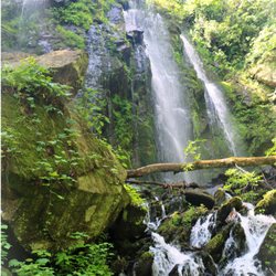
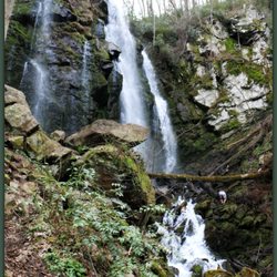
Station Cove Falls was the first waterfall we went to on the last Hiking Yelp Event hosted by Richard and Jamarcus which was also my first one. Not only my first Hiking Event but also my first time hiking. This time this guys took us to chase waterfalls to Walhalla, South Carolina. Definitely a great choice with beautiful views (which is why I live for, great views). The itinerary consisted on the following waterfalls: * Station Cove Falls King Creek Falls Spoonauger Falls Issaqueena Falls Yellow Branch Falls To a great start I think Station Cove was perfect. It was pretty easy (even for a beginner) and it is only about 0.75 miles making it 1.5 round trip. I didn't realize how easy hiking can be. There are indications and marks all over the place to help people follow the right way. My group was super experimented but I feel it would be totally fine for beginners too. No worries. Once we got to the waterfall I definitely fell in love with it and it encouraged me to keep going for the ones we still had on the list. This beauty is just about 60 foot long but it is truly majestic. Definitely worth it. I had so much fun on this event and I discovered what can be my new passion. Shoutout to Richard and his wife Dani for being so helpful and awesome. Every single person at the group was super nice too and willing to wait for me when i was getting too slow. LOL. Thanks y'all. Can't wait for the nexts events coming up. ESPAÑOL Station Cove Falls fue la primera cascada a la que asistimos en el último Evento de Yelp de Senderismo organizado por Richard y Jamarcus, que también fue el primero. No solo mi primer evento de senderismo, sino también mi primera vez. Esta vez, estos muchachos nos llevaron a cazar cascadas a Walhalla, Carolina del Sur. Definitivamente una gran elección con hermosas vistas (por lo que vivo por, excelentes vistas). El itinerario consistió en las siguientes cataratas: * Estación Cove Falls King Creek Falls Spoonauger Falls Issaqueena Falls Rama amarilla Falls Para un gran comienzo, creo que Station Cove fue perfecto. Fue bastante fácil (incluso para un principiante) y está a solo 0.75 millas, lo que hace que sea 1.5 ida y vuelta. No me di cuenta de lo fácil que puede ser el senderismo. Hay indicaciones y marcas por todo el lugar para ayudar a las personas a seguir el camino correcto. Mi grupo fue súper experimentado, pero creo que también estaría bien para los principiantes. Sin preocupaciones. Una vez que llegamos a la cascada, definitivamente me enamoré de ella y me alentó a continuar con las que aún teníamos en la lista. Esta belleza tiene aproximadamente 60 pies de largo, pero es verdaderamente majestuosa. Definitivamente vale la pena. Me divertí mucho en este evento y descubrí cuál puede ser mi nueva pasión. Grita a Richard y su esposa Dani por ser tan serviciales e increíbles. Cada persona del grupo también era súper agradable y estaba dispuesta a esperarme cuando me estaba volviendo demasiado lento. Jajaja Gracias a todos. No puedo esperar a los próximos eventos.

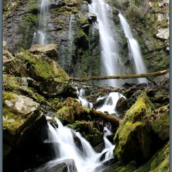
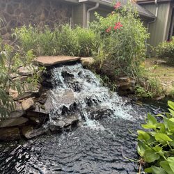
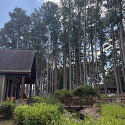
Station Cove Falls is a light and easy hike to a stunning 60 foot waterfall totaling 1.5 miles round trip. Not only is the trail terrain super easy and friendly to all ages & skill levels, it may be the most well marked hiking trail I've ever seen. A blaze is a color marker along a trail to let you know you are going in the right direction in the even the trail becomes overgrown and hard to see. They are also extremely useful on long trails where other trails intersect, leaving the hiker to wonder which way to go. Station Cove Falls utilizes BLUE blazes to mark the trail... and LOTS of them! I'm honesty happy if I find a blaze every 1/6th of a mile or so, but the blaze markers on this trail seem to be about every 50 feet. Unless you are not aware of blaze markers it is impossible to get lost, making this trail ideal for beginners. The waterfall is highly photogenic and extremely satisfying. Some waterfalls can feel closed off and restrictive with low visibility because of lots of surrounding vegetation. My wife is particularly sensitive to this because she gets easily spooked, wondering if wild animals are lurking in the thick vegetation. It makes her not able to fully relax even at some of the prettiest of waterfalls. Station Cove feels open and welcoming! The ambiance of the area makes you want to stay for a while, so bring a picnic if you feel inclined. I read on a web page titled Waterfalls of Oconee County that there is another waterfall above Station Cove, but the hike to it is off trail, steep and not for the unskilled. If you look carefully at one of my photo's, there were a group of young adult hikers at the top of the falls taking pictures. FINAL THOUGHTS I visited 5 waterfalls today, and while a few were much larger, only one ranks higher on my list of favorites from our adventure today (Yellow Branch Falls). Also nearby is Issaqueena Falls, my third favorite waterfall of today's exploration. ENJOY!!! 2019/15

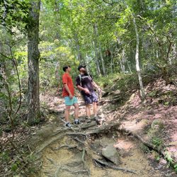
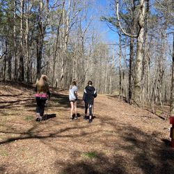
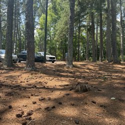
Station cove falls was first up on our day trip to multiple waterfalls, and this was a good first start! The hardest part of Station cove may very well be the parking. The trail head is found on the side of the road and outside of a dirt clearing and a marker on Oconee Station road, it can be hard to miss if you're not looking for it, and sometimes even if you are! All natural trail, station cove is more of a nature walk than a hike, with trail that is friendly to all fitness levels and age. Being an in and out trail at roughly 1.3 miles round trip, I think it's worth it to reach the actual falls. In addition to being an easy trail, this trail is filled with blazes (those little colored markers you see on trees along some trails), so much so that it's a little excessive, so you certainly wont get lost here. Being surrounded by the Sumter national forest, there's tons of lush forest surrounding you at all times, and it's worth it to keep an eye on your surroundings for some nice blooms growing here and there. The falls themselves are also beautiful, standing at approximately 60 feet, the falls are full, wide and powerful. It's a nice cap on a brisk walk, and yes, photos don't do it justice. Located in Oconee County, near Walhalla, SC, this is a waterfall that's well worth seeing if you're in the area. Even if you're like the group I came with, who all were out of the Atlanta area, it's not quite 2 hours drive from Atlanta to here, and if combining Station Cove falls with another hike or two, i'd highly recommend it! FYI, no restrooms here outside of tree, so plan accordingly

Shoutout to Richard and Jamarcus for organizing the Yelp UYE waterfalls trips again. I learned about so many waterfalls I've never would've known or even gotten together to go explore. I've always loved waterfalls and used to force my family to go to all the local parks with them and up north before Yelp was a thing. Walhalla SC has great waterfalls! Plus they are all close by. It reminds me of Helen where there is just more to be discovered! Station Cove Falls is a great waterfall destination. What makes it great for Atlantans is, it's really close to GA and not far from the border. It's a short hike with a round trip distance of 1.5 miles. The waterfall is gorgeous and you could go close up to it but just be careful. The trail is very well marked. Parking can be a mess if you don't come early. I was posing for hubby to take photos and a dog photobombed me. She's so cute and had a collar. We found out from local hikers that dog lives nearby and often goes hiking. Makes me miss my dog so much RIP! I shall come back to Walhalla again to explore the waterfalls that I wasn't able to with the group. 45/2019

These falls are beautiful. I highly recommend checking them out. If you want a longer hike start at the Oconee Station State Historic Site. There are bathrooms there. If you prefer an easier, shorter hike then drive past the historic site and the trailhead, and parking, are on the left. If you start at the historic site, know that you will eventually just be crossing that same street to get to the trailhead. read more


1 year ago
Station cove falls is the perfect family hike to start the day. There is immediate gratification when the falls come quickly! Our four and eight year old walked easily. We did backpack wear our 2 year old but to keep moving. The falls are 60 feet tall and offer a great opportunity for pictures especially for child photographers because of how close you. The hike is short at 1.6 miles out and back but honestly didnt feel that at all!. The majority is smooth and shaded! The waterfall spray and unit surroundings allow for plants to grow that wouldn't normally thrive there. Take the hike! read more


Station Cove Falls was the first waterfall we went to on the last Hiking Yelp Event hosted by Richard and Jamarcus which was also my first one. Not only my first Hiking Event but also my first time hiking. This time this guys took us to chase waterfalls to Walhalla, South Carolina. Definitely a great choice with beautiful views (which is why I live for, great views). The itinerary consisted on the following waterfalls: * Station Cove Falls King Creek Falls Spoonauger Falls Issaqueena Falls Yellow Branch Falls To a great start I think Station Cove was perfect. It was pretty easy (even for a beginner) and it is only about 0.75 miles making it 1.5 round trip. I didn't realize how easy hiking can be. There are indications and marks all over the place to help people follow the right way. My group was super experimented but I feel it would be totally fine for beginners too. No worries. Once we got to the waterfall I definitely fell in love with it and it encouraged me to keep going for the ones we still had on the list. This beauty is just about 60 foot long but it is truly majestic. Definitely worth it. I had so much fun on this event and I discovered what can be my new passion. Shoutout to Richard and his wife Dani for being so helpful and awesome. Every single person at the group was super nice too and willing to wait for me when i was getting too slow. LOL. Thanks y'all. Can't wait for the nexts events coming up. ESPAÑOL Station Cove Falls fue la primera cascada a la que asistimos en el último Evento de Yelp de Senderismo organizado por Richard y Jamarcus, que también fue el primero. No solo mi primer evento de senderismo, sino también mi primera vez. Esta vez, estos muchachos nos llevaron a cazar cascadas a Walhalla, Carolina del Sur. Definitivamente una gran elección con hermosas vistas (por lo que vivo por, excelentes vistas). El itinerario consistió en las siguientes cataratas: * Estación Cove Falls King Creek Falls Spoonauger Falls Issaqueena Falls Rama amarilla Falls Para un gran comienzo, creo que Station Cove fue perfecto. Fue bastante fácil (incluso para un principiante) y está a solo 0.75 millas, lo que hace que sea 1.5 ida y vuelta. No me di cuenta de lo fácil que puede ser el senderismo. Hay indicaciones y marcas por todo el lugar para ayudar a las personas a seguir el camino correcto. Mi grupo fue súper experimentado, pero creo que también estaría bien para los principiantes. Sin preocupaciones. Una vez que llegamos a la cascada, definitivamente me enamoré de ella y me alentó a continuar con las que aún teníamos en la lista. Esta belleza tiene aproximadamente 60 pies de largo, pero es verdaderamente majestuosa. Definitivamente vale la pena. Me divertí mucho en este evento y descubrí cuál puede ser mi nueva pasión. Grita a Richard y su esposa Dani por ser tan serviciales e increíbles. Cada persona del grupo también era súper agradable y estaba dispuesta a esperarme cuando me estaba volviendo demasiado lento. Jajaja Gracias a todos. No puedo esperar a los próximos eventos. read more


7 years ago
Station Cove Falls is a light and easy hike to a stunning 60 foot waterfall totaling 1.5 miles round trip. Not only is the trail terrain super easy and friendly to all ages & skill levels, it may be the most well marked hiking trail I've ever seen. A blaze is a color marker along a trail to let you know you are going in the right direction in the even the trail becomes overgrown and hard to see. They are also extremely useful on long trails where other trails intersect, leaving the hiker to wonder which way to go. Station Cove Falls utilizes BLUE blazes to mark the trail... and LOTS of them! I'm honesty happy if I find a blaze every 1/6th of a mile or so, but the blaze markers on this trail seem to be about every 50 feet. Unless you are not aware of blaze markers it is impossible to get lost, making this trail ideal for beginners. The waterfall is highly photogenic and extremely satisfying. Some waterfalls can feel closed off and restrictive with low visibility because of lots of surrounding vegetation. My wife is particularly sensitive to this because she gets easily spooked, wondering if wild animals are lurking in the thick vegetation. It makes her not able to fully relax even at some of the prettiest of waterfalls. Station Cove feels open and welcoming! The ambiance of the area makes you want to stay for a while, so bring a picnic if you feel inclined. I read on a web page titled Waterfalls of Oconee County that there is another waterfall above Station Cove, but the hike to it is off trail, steep and not for the unskilled. If you look carefully at one of my photo's, there were a group of young adult hikers at the top of the falls taking pictures. FINAL THOUGHTS I visited 5 waterfalls today, and while a few were much larger, only one ranks higher on my list of favorites from our adventure today (Yellow Branch Falls). Also nearby is Issaqueena Falls, my third favorite waterfall of today's exploration. ENJOY!!! 2019/15 read more


 - Hiking Near Me - Walhalla, South Carolina")
7 years ago
Station cove falls was first up on our day trip to multiple waterfalls, and this was a good first start! The hardest part of Station cove may very well be the parking. The trail head is found on the side of the road and outside of a dirt clearing and a marker on Oconee Station road, it can be hard to miss if you're not looking for it, and sometimes even if you are! All natural trail, station cove is more of a nature walk than a hike, with trail that is friendly to all fitness levels and age. Being an in and out trail at roughly 1.3 miles round trip, I think it's worth it to reach the actual falls. In addition to being an easy trail, this trail is filled with blazes (those little colored markers you see on trees along some trails), so much so that it's a little excessive, so you certainly wont get lost here. Being surrounded by the Sumter national forest, there's tons of lush forest surrounding you at all times, and it's worth it to keep an eye on your surroundings for some nice blooms growing here and there. The falls themselves are also beautiful, standing at approximately 60 feet, the falls are full, wide and powerful. It's a nice cap on a brisk walk, and yes, photos don't do it justice. Located in Oconee County, near Walhalla, SC, this is a waterfall that's well worth seeing if you're in the area. Even if you're like the group I came with, who all were out of the Atlanta area, it's not quite 2 hours drive from Atlanta to here, and if combining Station Cove falls with another hike or two, i'd highly recommend it! FYI, no restrooms here outside of tree, so plan accordingly read more


Shoutout to Richard and Jamarcus for organizing the Yelp UYE waterfalls trips again. I learned about so many waterfalls I've never would've known or even gotten together to go explore. I've always loved waterfalls and used to force my family to go to all the local parks with them and up north before Yelp was a thing. Walhalla SC has great waterfalls! Plus they are all close by. It reminds me of Helen where there is just more to be discovered! Station Cove Falls is a great waterfall destination. What makes it great for Atlantans is, it's really close to GA and not far from the border. It's a short hike with a round trip distance of 1.5 miles. The waterfall is gorgeous and you could go close up to it but just be careful. The trail is very well marked. Parking can be a mess if you don't come early. I was posing for hubby to take photos and a dog photobombed me. She's so cute and had a collar. We found out from local hikers that dog lives nearby and often goes hiking. Makes me miss my dog so much RIP! I shall come back to Walhalla again to explore the waterfalls that I wasn't able to with the group. 45/2019 read more


5 years ago
7 years ago
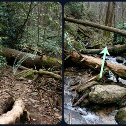
I hiked this trial with several others Yelpers on my first "Off the Grid" hiking Unofficial Yelp Event. This was our first hike of the day. We had perfect weather for our hike: sunny with a nice breeze. The trail was a little muddy/mushy from previous rain storms, but nothing out of the usual. When you put the address of this waterfall in your GPS, beware that it tells you to turn on White Cut Road. DO NOT turn there! Instead keep going straight for like 30 more seconds and you will see a gravel parking lot and an entrance to the trail. I would categorize this trail as "easy," as there were no difficult parts on the trail. It was pretty straight forward and was a very quick walk to see a beautiful waterfall. This was my favorite waterfall to take pictures at because it had tons of large rocks to stand on and great angles to get some pretty awesome pictures. During our visit, we even saw a rainbow appear in the falls, which was pretty magical! read more


7 years ago
More info about Station Cove Falls
State Rd S-37-95
Walhalla, SC 29691
Directions
Hours
Outdoor Amenities
Ask the Community - Station Cove Falls
Review Highlights - Station Cove Falls


Station Cove Falls - hiking - Updated June 2026
Best of Walhalla
People found Station Cove Falls by searching for…
Hiking Trails With Waterfalls in Walhalla, South Carolina
Parks in Walhalla, South Carolina
Places to Take Pictures in Walhalla, South Carolina
Things to Do in Walhalla, South Carolina
Fishing in Walhalla, South Carolina
Scenic Overlook in Walhalla, South Carolina
Waterfalls in Walhalla, South Carolina
Walking Trails in Walhalla, South Carolina
Off Road Trails in Walhalla, South Carolina
Beautiful Views in Walhalla, South Carolina
Photo Spots in Walhalla, South Carolina
Waterfalls and Swimming Holes in Walhalla, South Carolina
Secret Spots in Walhalla, South Carolina
Lookout Points in Walhalla, South Carolina
Dog Friendly Trails in Walhalla, South Carolina
Picnic Areas in Walhalla, South Carolina
Easy Hikes in Walhalla, South Carolina
Running Trails in Walhalla, South Carolina
Parks for Picnics in Walhalla, South Carolina
Secluded Spots in Walhalla, South Carolina
Kids Play Area in Walhalla, South Carolina
Rock in Walhalla, South Carolina
Trending Searches in Walhalla, SC
Black Owned Nail Salons near Station Cove Falls
Boat Rental near Station Cove Falls
Cliff Jumping near Station Cove Falls
Day Trips near Station Cove Falls
Dog Friendly Trails near Station Cove Falls
Jet Ski Rental near Station Cove Falls
Kayak Rental near Station Cove Falls
Lakes & Ponds near Station Cove Falls
Off Road Trails near Station Cove Falls
Outdoor Activities near Station Cove Falls
Pool Supplies near Station Cove Falls
Public Shower near Station Cove Falls
River Swimming near Station Cove Falls
River Tubing near Station Cove Falls
Rock Quarry near Station Cove Falls
Running Trails near Station Cove Falls
Scenic Overlook near Station Cove Falls
Secluded Spots near Station Cove Falls
Soccer Store near Station Cove Falls
Strawberry Picking near Station Cove Falls
Sunrise View near Station Cove Falls
Swimming Holes near Station Cove Falls
Swimming Lakes near Station Cove Falls
U Pick Farms near Station Cove Falls
Watch Sunset near Station Cove Falls
Browse Articles
Browse Brands
Related Searches in Walhalla, SC
Affordable Jet Ski Rental Options in Walhalla, South Carolina
Affordable Kayak Rental Services in Walhalla, South Carolina
Best Fishing Locations and Guides in Walhalla, South Carolina
Best Places for Horseback Riding in Walhalla, South Carolina
Best Places for Stunning Views in Walhalla, South Carolina
Best Spots for Star Gazing in Walhalla, South Carolina
Check Out Off Road Trails in Walhalla, South Carolina
Discover Popular Photo Spots in Walhalla, South Carolina
Discover the Best Night Hike Trails in Walhalla, South Carolina
Enjoy the Best Tubing Experiences in Walhalla, South Carolina
Enjoy the Best Walking Trails in Walhalla, South Carolina
Exciting Cliff Jumping Spots in Walhalla, South Carolina
Explore Beautiful Botanical Gardens in Walhalla, South Carolina
Explore Beautiful Parks and Green Spaces in Walhalla, South Carolina
Explore Bike Rentals Throughout Walhalla, South Carolina
Explore Family-Friendly Zoos and Wildlife in Walhalla, South Carolina
Explore Free Things to Do Around Walhalla, South Carolina
Explore Fun Activities to Do in Walhalla, South Carolina
Explore Jet Skis for Sale or Rent in Walhalla, South Carolina
Explore Popular Campgrounds Near Walhalla, South Carolina
Explore Popular RV Parks Around Walhalla, South Carolina
Explore Popular Scenic Overlook Points in Walhalla, South Carolina
Explore Popular View Points Around Walhalla, South Carolina
Explore Scenic Lakes to Visit in Walhalla, South Carolina
Explore Top Dog Parks in Walhalla, South Carolina Near You
Explore Top Water Parks in Walhalla, South Carolina Today
Explore the Best Boating Spots in Walhalla, South Carolina
Find Popular Ziplining Spots Around Walhalla, South Carolina
Find Top Dog Swimming Spots in Walhalla, South Carolina
Find Top Skate Parks in Walhalla, South Carolina for All Skill Levels
Find Top-Rated Disc Golf in Walhalla, South Carolina
Find the Best Playgrounds to Visit in Walhalla, South Carolina
Find the Best Scenic View Locations in Walhalla, South Carolina
Find the Best Swimming Pools in Walhalla, South Carolina Today
Hiking Trails With Waterfalls in Walhalla, South Carolina
Must-See Tourist Attractions Around Walhalla, South Carolina
Perfect Spots to Watch Sunset in Walhalla, South Carolina
Plan a Scenic Drive Route Near Walhalla, South Carolina
Popular Kids Activities in Walhalla, South Carolina
Popular Places to Take Pictures in Walhalla, South Carolina
Popular Things to Do in Walhalla, South Carolina
Relax at Natural Hot Springs Near Walhalla, South Carolina
Safe and Fun Parks for Kids in Walhalla, South Carolina
See Top Fireworks Events in Walhalla, South Carolina
Top Climbing Spots and Gyms in Walhalla, South Carolina
Top Paddleboarding Activities in Walhalla, South Carolina
Top Swimming Lakes to Enjoy in Walhalla, South Carolina
Top Things to Do With Kids in Walhalla, South Carolina
Top Things to Do With Teenagers in Walhalla, South Carolina
Top-Rated Basketball Courts to Play at in Walhalla, South Carolina
People who viewed Station Cove Falls also viewed
Brasstown Falls
4 reviews
Chau Ram County Park
15 reviews
Devil's Fork State Park
41 reviews
South Cove County Park
8 reviews
Lee Falls Trailhead
2 reviews
Reedy Branch Falls Trailhead
4 reviews
High Falls County Park
7 reviews
Long Shoals Wayside Park
6 reviews
Waldrop Stone Falls
1 review
Table Rock State Park
1 review