Chau Ram County Park Photos


You might also consider
More like Chau Ram County Park
Recommended Reviews - Chau Ram County Park
Start your review...

Reviews With Photos


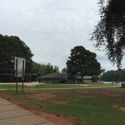
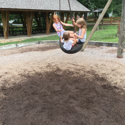
Chau Ram County Park is a beautifully maintained place that has been dubbed Oconee County's "Best Kept Secret" by the Oconee County Parks Recreation and Tourism department. Located just off Hwy 76 travelling northwest from the small town of Westminster, it is about as far west as you can get in the state of South Carolina. I wonder if that has something to do with the name of the town? The name Chau Ram seems to be derived from the park location, which is at the confluence of the Chauga River and Ramsey Creek. { THINGS TO SEE & DO } While many use the park for camping and picnics, there is also a waterfall here that makes for a great background for wedding, engagement, or family photos. It is said to be 40' tall, but doesn't quite look that large in person. Views downriver are spectacular and there are plenty of places to safely play in the water for hours. Speaking of play, there is also a picturesque playground area for younger kids complete with slides, swings and two gazebos. Another feature to this park is the 160-foot wooden suspension bridge spanning the Chauga River. The bridge helps connect about 4 miles of trails through the park and along the river. Entrance into the park is $2 per car, but highly worth it if you plan to stay a while. There are also 4 major sets of rapids within the park for kayaking, canoeing and/or tubing, but you must bring your own tube. The Pumphouse, the Can-Opener and the V are the names to three of the rapids within the park. According to their website, a kayak slalom course is available for instruction or competition use. There are 28 campsites each with power and water as well as a communal dump station and a bathhouse. [ FINAL THOUGHTS ] Whether you want to have a relaxing picnic, an overnight camping experience, a kayak/canoe/tubing adventure, a safe place to spend the day with your little ones or just want a great selfie with a beautiful waterfall without having to hike... Chau Ram County Park is a nice quiet destination. Sorry Chau Ram, the secret is out! 2019/47

We took a day trip to travel to Westminster and checked out this park. It was lovely. They have a couple of hiking trails with few people. Great for young kids. Not great for trail runners as there are many rocks and roots along the path. The water was beautiful. People were floating on rafts. We will be back. Oh, they also have picnic tables with grills, porta potties and a brand NEW restroom facility. The restrooms were clean. Masks are required with COVID19.

The park was a delightful surprise. It is small, which we liked, and our 37 foot Road Pig fit, but some of the turns were tight. The camp sites had the basics covered with water and electric. There was a dump station when you first arrive. The Park Ranger we met, Rec, (I swear it's his name), made us feel super welcome and chatted with us about our adventures and his! The best part for us were the waterfalls and the hiking. The trails made for fantastic exploration points. My children would not stop adventuring! They could also get into the water and check things out as little boys do. There were multiple play areas for them too, with swings or climbing sets.


3 years ago


1 year ago
I've been wanting to go to Chau Ram County Park for a few years. When I wanted to go, it rained. Then I forgot about it. This time, I made sure to come. I dragged my husband with me since it was a nice day. It was a 2-hour drive. The GA-SC border has lots of gorgeous waterfalls. $2 parking Interesting enough, we arrived and saw another group of familiar faces! Coincidentally, we saw Richard and his family there! He was there with another group of hikers. This is an easy "hike" - all you had to do was walk behind the visitor's center and the waterfall is there. However, we went on the trail to go behind on top of the rock where the waterfall is. You can tell there's still lots of renovating. It has beautiful scenery. 17/2020 read more

3 years ago
Easy access to first waterfall! Kids park, picnic area and swimming too! Great place for families or just n ed a place to hike read more
3 years ago
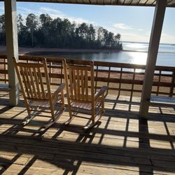
Beautiful park with very well kept picnic areas and trails. Chau Ram is very unique with its different swimming holes and it is a must for any nature lover!! There is even a suspension bridge. Younger kids can enjoy the beach area and calm waters there too. read more


7 years ago
Chau Ram County Park is a beautifully maintained place that has been dubbed Oconee County's "Best Kept Secret" by the Oconee County Parks Recreation and Tourism department. Located just off Hwy 76 travelling northwest from the small town of Westminster, it is about as far west as you can get in the state of South Carolina. I wonder if that has something to do with the name of the town? The name Chau Ram seems to be derived from the park location, which is at the confluence of the Chauga River and Ramsey Creek. { THINGS TO SEE & DO } While many use the park for camping and picnics, there is also a waterfall here that makes for a great background for wedding, engagement, or family photos. It is said to be 40' tall, but doesn't quite look that large in person. Views downriver are spectacular and there are plenty of places to safely play in the water for hours. Speaking of play, there is also a picturesque playground area for younger kids complete with slides, swings and two gazebos. Another feature to this park is the 160-foot wooden suspension bridge spanning the Chauga River. The bridge helps connect about 4 miles of trails through the park and along the river. Entrance into the park is $2 per car, but highly worth it if you plan to stay a while. There are also 4 major sets of rapids within the park for kayaking, canoeing and/or tubing, but you must bring your own tube. The Pumphouse, the Can-Opener and the V are the names to three of the rapids within the park. According to their website, a kayak slalom course is available for instruction or competition use. There are 28 campsites each with power and water as well as a communal dump station and a bathhouse. [ FINAL THOUGHTS ] Whether you want to have a relaxing picnic, an overnight camping experience, a kayak/canoe/tubing adventure, a safe place to spend the day with your little ones or just want a great selfie with a beautiful waterfall without having to hike... Chau Ram County Park is a nice quiet destination. Sorry Chau Ram, the secret is out! 2019/47 read more


6 years ago
6 years ago
We took a day trip to travel to Westminster and checked out this park. It was lovely. They have a couple of hiking trails with few people. Great for young kids. Not great for trail runners as there are many rocks and roots along the path. The water was beautiful. People were floating on rafts. We will be back. Oh, they also have picnic tables with grills, porta potties and a brand NEW restroom facility. The restrooms were clean. Masks are required with COVID19. read more


9 years ago
The park was a delightful surprise. It is small, which we liked, and our 37 foot Road Pig fit, but some of the turns were tight. The camp sites had the basics covered with water and electric. There was a dump station when you first arrive. The Park Ranger we met, Rec, (I swear it's his name), made us feel super welcome and chatted with us about our adventures and his! The best part for us were the waterfalls and the hiking. The trails made for fantastic exploration points. My children would not stop adventuring! They could also get into the water and check things out as little boys do. There were multiple play areas for them too, with swings or climbing sets. read more


6 years ago
7 years ago
Amazing waterfalls very close to parking so you dont have to hike to see them. For $2 a car to get in it is a great place to go! read more


5 years ago
This place was recommended to us by some folks staying at the Magnolia Manor and they said it was just up the road. So Sunday morning we checked out and yep it was just up the road! The Oconee County Parks Recreation and Tourism department calls Chau Ram County Park Oconee County's "Best Kept Secret." And they may be right! As you drive into the parking are you can see the falls right in front of you. Chau Ram County Park is located west of Westminster, SC, on 200 acres running along the Chauga River. Ramsey Creek Falls is a beautiful 30-foot cascading falls in the center of the park. There are five other falls located on the Chauga River which are accessible by crossing the 175-foot pedestrian suspension bridge over the Chauga River (longest suspension bridge in the county) it gives access to both sides of the river and to clear, clean paths that lead both up and down the river to other waterfalls. It looks like you can kayak or inner tube some of the rapids if you desire. I didn't desire! To cold and Im to old! Just say! Everything was easy to get to and they have a large playground area for the kids. We read that there is 28 campsites here. If you are visiting the area or looking for a place to have a picnic, this is a great spot. Oh yes the have very clean restroom! With plenty of paper! read more


10 years ago
8 years ago
More info about Chau Ram County Park
Ask the Community - Chau Ram County Park
Review Highlights - Chau Ram County Park


Chau Ram County Park - parks - Updated July 2026
Best of Westminster
People found Chau Ram County Park by searching for…
Beaches in Westminster, South Carolina
Fishing in Westminster, South Carolina
Campgrounds in Westminster, South Carolina
Swimming Holes in Westminster, South Carolina
Playgrounds in Westminster, South Carolina
Hiking Trails With Waterfalls in Westminster, South Carolina
Hiking in Westminster, South Carolina
Photo Spots in Westminster, South Carolina
Water Parks in Westminster, South Carolina
Things to Do in Westminster, South Carolina
Scenic Drive in Westminster, South Carolina
Waterfalls in Westminster, South Carolina
River Swimming in Westminster, South Carolina
Places to Swim in Westminster, South Carolina
Running Trails in Westminster, South Carolina
Fishing Spots in Westminster, South Carolina
Parks for Picnics in Westminster, South Carolina
Scenic Views in Westminster, South Carolina
Places to Take Pictures in Westminster, South Carolina
Beautiful Views in Westminster, South Carolina
Walking Trails in Westminster, South Carolina
Gazebos in Westminster, South Carolina
Trending Searches in Westminster, SC
Boat Rental near Chau Ram County Park
Day Trips near Chau Ram County Park
Fireworks near Chau Ram County Park
Fruit Picking near Chau Ram County Park
Jet Ski Rental near Chau Ram County Park
Kayak Rental near Chau Ram County Park
Lakes near Chau Ram County Park
Peach Picking near Chau Ram County Park
Playgrounds near Chau Ram County Park
Public Pools near Chau Ram County Park
River Swimming near Chau Ram County Park
Splash Pad near Chau Ram County Park
Strawberry Picking near Chau Ram County Park
Swimming Holes near Chau Ram County Park
Swimming Lakes near Chau Ram County Park
U Pick Farms near Chau Ram County Park
Watch Sunset near Chau Ram County Park
Browse Articles
Browse Brands
Related Searches in Westminster, SC
Best Fishing Locations and Guides in Westminster, South Carolina
Best Places for Horseback Riding in Westminster, South Carolina
Best Waterfalls and Swimming Holes in Westminster, South Carolina
Discover Fun Activities to Do in Westminster, South Carolina
Discover Popular Photo Spots in Westminster, South Carolina
Discover the Best Beaches in Westminster, South Carolina
Discover the Best Running Track in Westminster, South Carolina
Enjoy the Best Night View Spots in Westminster, South Carolina
Enjoy the Best Tubing Experiences in Westminster, South Carolina
Exciting Cliff Jumping Spots in Westminster, South Carolina
Explore Family-Friendly Zoos and Wildlife in Westminster, South Carolina
Explore Free Things to Do Around Westminster, South Carolina
Explore Fun Activities to Do in Westminster, South Carolina
Explore Landmarks & Historical Buildings in Westminster, South Carolina
Explore Popular Campgrounds Near Westminster, South Carolina
Explore Popular RV Parks Around Westminster, South Carolina
Explore Popular View Points Around Westminster, South Carolina
Explore Scenic Lakes to Visit in Westminster, South Carolina
Explore Summer Camps for All Ages in Westminster, South Carolina
Explore Top Dog Parks in Westminster, South Carolina Near You
Explore Top Gyms in Westminster, South Carolina Now
Explore Top Water Parks in Westminster, South Carolina Today
Explore Volleyball Courts Available in Westminster, South Carolina
Explore the Best Swimming Holes Around Westminster, South Carolina
Find Indoor Basketball Courts in Westminster, South Carolina
Find Top Dog Friendly Parks to Visit in Westminster, South Carolina
Find Top Dog Swimming Spots in Westminster, South Carolina
Find Top Skate Parks in Westminster, South Carolina for All Skill Levels
Find the Best Swimming Pools in Westminster, South Carolina Today
Great Places to Swim in Westminster, South Carolina
Have Fun at a Splash Pad in Westminster, South Carolina
Hiking Trails With Waterfalls in Westminster, South Carolina
Host the Perfect Kids Birthday Party in Westminster, South Carolina
Indoor Playgrounds to Explore in Westminster, South Carolina
Locate a Public Shower Facility in Westminster, South Carolina
Perfect Spots to Watch Sunset in Westminster, South Carolina
Popular Kids Activities in Westminster, South Carolina
Popular Places to Take Pictures in Westminster, South Carolina
Popular Things to Do in Westminster, South Carolina
Relax at Natural Hot Springs Near Westminster, South Carolina
See Top Fireworks Events in Westminster, South Carolina
Top Hiking Trails to Explore in Westminster, South Carolina
Top Indoor Swimming Pools to Visit in Westminster, South Carolina
Top Swimming Lakes to Enjoy in Westminster, South Carolina
Top Things to Do With Kids in Westminster, South Carolina
Top-Rated Boat Rental Services in Westminster, South Carolina
Visit Popular Museums in Westminster, South Carolina Now
Visit Top Toddler Playgrounds in Westminster, South Carolina for Playtime
People who viewed Chau Ram County Park also viewed
Station Cove Falls
11 reviews
Lake Hartwell State Park
8 reviews
Riley Moore Falls
4 reviews
The Oasis Ranch
30 reviews
Todd Creek Falls
4 reviews
Long Shoals Wayside Park
6 reviews
Currahee Mountain
4 reviews
Tallulah Gorge State Park
209 reviews
Dick's Creek Falls
3 reviews
Rabun Bald via Beegum Gap Trail
10 reviews