Riley Moore Falls Photos


More like Riley Moore Falls
Recommended Reviews - Riley Moore Falls
Start your review...

1 year ago
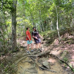
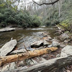
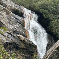
This is the best waterfall we got to visit in SC this far. After we left Reedy Branch Falls we drove here. Well, as close as we could get. I didn't realize that we couldn't drive all the way to the trailhead so we had a long hike in store due to me having to carry my toddler most of the time. I should have re-read the previous reviews before coming. My friend did help me carry her as well and for that I was very thankful. So definitely don't recommend this hike with a little one unless strapped in a carrier. Also, I don't recommend it for the elderly either. It's definitely a wilderness hike deal with roots and elevation change. In fact, it's mostly downhill on the way to the falls, but on the way back it's pretty much all uphill, which was not fun with aforementioned young child. It's about a half mile to the actual trailhead and then another 0.7 mile to the falls. That's about 2.4 miles round trip. The reason of course that my boys absolutely became enamored with this place is the large swimming hole. It is wonderful and has plenty of space. The waterfall itself is beautiful and although it's not as tall as others, its width is quite impressive. I was trying to get as close as I could and even noticed a hidden part of the falls inside of the rock structure. That was so cool!! The sand at the base and shore give it a beachy vibe. We definitely packed it in and out making sure not to leave anything behind as to preserve the area as best as possible. Needless to say we were wiped by the time we made it back to our vehicles, but we're still glad we decided to venture here. Coming back with my hubby and boys in the very near future. Happy yelping! read more


4 years ago
I just wanted to update my 3/15/20 review below to add I've now done this hike several times, but THIS time I had the chance to hike it with a friend who is directly related to the namesake of the waterfall... Riley Moore. Sandie is a church friend of mine and Riley Moore was her Great Great Uncle (I believe that's right). He once upon a time operated a grist mill here at the top of the falls. She's been trying to get here to see the waterfall, but couldn't find it and wanted to join us (along with her family) since I knew the way. Upon further research I discovered there are actually still remnants of the mill including visible drill holes, spikes and bolts. Thought that was pretty cool info to share! [ [ [ PREVIOUS REVIEW ] ] ] Riley Moore Falls is small in height but HUGE in personality. It's located off State Road S37-748, which is a nicely maintained gravel road where cars and trucks alike can comfortably traverse. ~~~ DIRECTIONS From Westminster, SC - DO NOT turn onto Cobb Bridge Road from Long Creek Hwy (Hwy 76) where you will see the brown & white sign pointing you in the direction of Riley Moore Falls. Our GPS had us go this way, then left onto State Road S37-748, but the road was CLOSED during our visit! INSTEAD, turn onto PU-32 also known as Rocky Fork Road. Turn left onto a gravel road near Rocky Fork Baptist Church and follow that until it dead ends @ State Road S37-748 (also known as Spy Rock Road). Turn right and drive approx. 1.4 miles (4 minutes) to 748c (aka Riley Moore Shoals Road). Park at the intersection of State Road S37-748 and 748c. DO NOT ATTEMPT TO DRIVE 748c in a car or minivan. Low clearance vehicles will find the terrain on this road to be VERY difficult to navigate without bottoming out or getting stuck. I'd also recommend 4x4 capability on wet days! There can be several deep-pocketed muddy areas after heavy rains. ~~~ THE TRAIL Once you reach the intersection of Spy Rock Rd (S37-748) and 748c, park roadside on Spy Rock, secure your vehicle and begin your hike approx. 1/2 mile down the "primitive road." IF you have a high ground clearance SUV or truck, you can drive the primitive road another half mile or so to a second parking area near the trailhead. The primitive road is VERY BUMPY and can be muddy in spots after heavy rains, so a 4x4 is best. After reaching the second parking area, follow the marked trail on the left!!! The trail is a little over a 1/2 mile to the falls from here. The trail is fairly straightforward and easy to follow. ~~~ THE FALLS Once you reach the Chauga River, you will notice a large sandy area with plenty of room for an entire horde of hikers!!! Riley Moore Falls is not very tall (only about 12 feet), but it is very wide and has a deep base pool. PRO TIP - Bring swimwear, towels and a picnic, but be sure to pack it in and pack it out. ~~~ THINGS TO KNOW Hiking Distance: 2 miles (round trip to falls from S37-748) Difficulty of hiking 748c: All downhill to trailhead (moderate return) Difficulty of hiking trail to falls: EASY Creek Crossings: NO Elevation Gain: 357 feet Waterfall Height: Approx 12 feet Access to top of falls: NO - not without getting wet Access to base of falls: YES Pool of water @ base of Falls: YES Sitting areas @ base: YES + sandy beach RESTROOMS: NO PARKING: YES (along road) + secondary parking area closer to trailhead for trucks and high ground clearance vehicles with room for about 6 cars. ~~~ [ FINAL THOUGHTS ] A lovely waterfall in any season, but also a great spot for a summer swim. While we had the waterfall practically to ourselves during our Mid-March expedition, be advised other trail website reviews say it gets trashy & crowded in summer months. What a shame if that is true because it truly is a treasure. ENJOY! 2022 / 74 #UPDATE 178 read more


6 years ago
6 years ago
We did this hike from the second parking area. To disagree with a previous reviewer, there is no way anyone elderly would be able to hike to this waterfall. No way. The trail has steep parts, uneven ground, roots, some climbing up "steps" and it takes a while (35-45 min with kids). Our 4 yr old made it but the footing is too uneven for anyone much younger and definitely anyone elderly. That out of the way, the waterfall is beautiful. It was worth seeing once for sure. We might be back later if the kids ask. The swimming was good. People did leave some garbage and random left items unfortunately. There was a bad smell probably from trash, but it didn't ruin the experience. The scene is gorgeous and we had a great time. read more

More info about Riley Moore Falls


Riley Moore Falls - hiking - Updated June 2026
Best of Westminster
People found Riley Moore Falls by searching for…
Beaches in Westminster, South Carolina
Hiking Trails With Waterfalls in Westminster, South Carolina
Swimming Holes in Westminster, South Carolina
Parks in Westminster, South Carolina
Off Road Trails in Westminster, South Carolina
Things to Do in Westminster, South Carolina
Waterfalls in Westminster, South Carolina
Playgrounds in Westminster, South Carolina
Walking Trails in Westminster, South Carolina
Easy Hikes in Westminster, South Carolina
Picnic Areas in Westminster, South Carolina
Scenic Overlook in Westminster, South Carolina
Sunset View in Westminster, South Carolina
Places to Take Pictures in Westminster, South Carolina
Secret Spots in Westminster, South Carolina
Swimming Lakes in Westminster, South Carolina
Lookout Points in Westminster, South Carolina
Running Trails in Westminster, South Carolina
Photo Spots in Westminster, South Carolina
Secluded Spots in Westminster, South Carolina
River Swimming in Westminster, South Carolina
Natural Hot Springs in Westminster, South Carolina
Trending Searches in Westminster, SC
Boat Rental near Riley Moore Falls
Day Trips near Riley Moore Falls
Fruit Picking near Riley Moore Falls
Jet Ski Rental near Riley Moore Falls
Kayak Rental near Riley Moore Falls
Peach Picking near Riley Moore Falls
Pick Your Own Farms near Riley Moore Falls
Pool Supplies near Riley Moore Falls
River Swimming near Riley Moore Falls
Rock Quarry near Riley Moore Falls
Scenic Overlook near Riley Moore Falls
Splash Pad near Riley Moore Falls
Strawberry Picking near Riley Moore Falls
Swimming Holes near Riley Moore Falls
Swimming Lakes near Riley Moore Falls
Watch Sunset near Riley Moore Falls
Browse Articles
Browse Nearby
Browse Brands
Related Searches in Westminster, SC
Affordable Jet Ski Rental Options in Westminster, South Carolina
Affordable Long Term RV Parking in Westminster, South Carolina
Best Fishing Locations and Guides in Westminster, South Carolina
Best Places for Horseback Riding in Westminster, South Carolina
Best Waterfalls and Swimming Holes in Westminster, South Carolina
Discover Dog Friendly Trails to Explore in Westminster, South Carolina
Discover Popular Photo Spots in Westminster, South Carolina
Discover the Best Running Track in Westminster, South Carolina
Enjoy the Best Night View Spots in Westminster, South Carolina
Enjoy the Best Tubing Experiences in Westminster, South Carolina
Exciting Cliff Jumping Spots in Westminster, South Carolina
Explore Beautiful Parks and Green Spaces in Westminster, South Carolina
Explore Bike Rentals Throughout Westminster, South Carolina
Explore Family-Friendly Zoos and Wildlife in Westminster, South Carolina
Explore Free Things to Do Around Westminster, South Carolina
Explore Fun Activities to Do in Westminster, South Carolina
Explore Jet Skis for Sale or Rent in Westminster, South Carolina
Explore Popular Boat Charters Near Westminster, South Carolina
Explore Popular Campgrounds Near Westminster, South Carolina
Explore Popular RV Parks Around Westminster, South Carolina
Explore Popular View Points Around Westminster, South Carolina
Explore Scenic Lakes to Visit in Westminster, South Carolina
Explore Top Dog Parks in Westminster, South Carolina Near You
Explore Top Water Parks in Westminster, South Carolina Today
Explore Volleyball Courts Available in Westminster, South Carolina
Explore the Best Boating Spots in Westminster, South Carolina
Explore the Best Swimming Holes Around Westminster, South Carolina
Find Popular Ziplining Spots Around Westminster, South Carolina
Find Top Dog Friendly Parks to Visit in Westminster, South Carolina
Find Top Dog Swimming Spots in Westminster, South Carolina
Find Top Skate Parks in Westminster, South Carolina for All Skill Levels
Find the Best Playgrounds to Visit in Westminster, South Carolina
Find the Best Scenic View Locations in Westminster, South Carolina
Find the Best Swimming Pools in Westminster, South Carolina Today
Great Places to Swim in Westminster, South Carolina
Have Fun at a Splash Pad in Westminster, South Carolina
Hiking Trails With Waterfalls in Westminster, South Carolina
Locate a Public Shower Facility in Westminster, South Carolina
Perfect Spots to Watch Sunset in Westminster, South Carolina
Popular Kids Activities in Westminster, South Carolina
Popular Places to Take Pictures in Westminster, South Carolina
Popular Things to Do in Westminster, South Carolina
Relax at Natural Hot Springs Near Westminster, South Carolina
Safe and Fun Parks for Kids in Westminster, South Carolina
See Top Fireworks Events in Westminster, South Carolina
Top Climbing Spots and Gyms in Westminster, South Carolina
Top Playgrounds for Kids to Enjoy in Westminster, South Carolina
Top Swimming Lakes to Enjoy in Westminster, South Carolina
Top Things to Do With Kids in Westminster, South Carolina
Top-Rated Boat Rental Services in Westminster, South Carolina
People who viewed Riley Moore Falls also viewed
Panther Creek Recreation Area
37 reviews
Brasstown Falls
4 reviews
Reedy Branch Falls Trailhead
4 reviews
Martin Creek Falls
3 reviews
Chau Ram County Park
15 reviews
Black Rock Mountain State Park
57 reviews
Lee Falls Trailhead
2 reviews
Tugaloo State Park
26 reviews
Fall Creek Falls Trailhead
3 reviews
Southeastern Expeditions
61 reviews