Reedy Branch Falls Trailhead Photos


More like Reedy Branch Falls Trailhead
Recommended Reviews - Reedy Branch Falls Trailhead
Start your review...

11 months ago
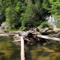
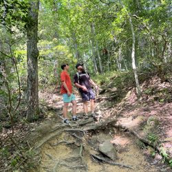
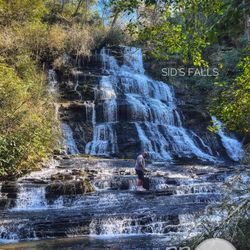
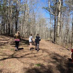
This gem of a waterfall isn't even listed in the brochure of SC waterfalls that I got at Lake Keowee last year. Good thing I had it bookmarked on here thankx to Richard R. I would have ventured here on my own with my 3 crazy children, but thankfully a friend met us here with her child. Very thankful indeed. The parking area is very small, allowing a few spots for cars. Had no problem finding space on a Tuesday afternoon. The trail to the waterfall is very short, maybe 3-5 minutes. Not difficult at all so that even older folks and toddlers can manage it. The waterfall is gorgeous! There is a small wading area at the base, so we strapped on our water shoes and explored. It's not quite large enough to swim around comfortably, but does become deeper the closer you go to the falls. I did manage to climb up some of the rocks on the left side, but it was quite slippery so I took my time. Apparently, there is access to climb up to the top on the right side as well, but that looked too dangerous for me. We even saw a not-so-small crayfish in the water with its claws. We had this place to ourselves for a good 25 minutes before a young couple showed up. I'm sure it wasn't the romantic moment they were looking for. I really hope the guy wasn't planning a proposal, because when we finally left another family with floats was already heading that way. Haha. Maybe it's not as secluded as I thought. We ended up heading to another waterfall, but on the way there I saw a strange Wild West style town on Hwy. 76. Can anyone tell me what that is all about?? I tried to Google it, but couldn't find it and I need to know that I'm not going crazy and seeing ghost towns. Thank you in advance! Planning on coming back here very soon with my hubby and boys. Happy yelping! read more


1 year ago
7 years ago
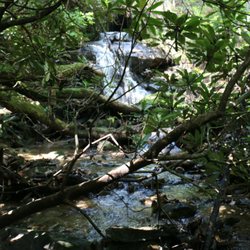
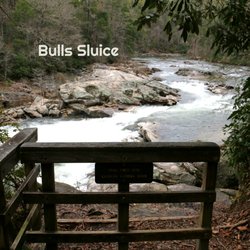
This is truly a hidden gem! Reedy branch falls is accessed off Long Creek Hywy (route 76) in South Carolina near Chattooga Ridge Road. The entrance is very easy to overlook because there are no signs telling you of its existence. Look for a pull-off that can hold about 5 cars comfortably near coordinates: 34°48'26.7"N 83°16'51.2"W The stone entrance and gravel trail were once part of a builders plans to develop the land for homes, but the land was eventually purchased by the US Forest Service. Follow the wide gravel trail down to the river (about 250 yard) then turn left and cross a small wooden platform as the trail leads to the base of the falls. Reedy Branch Falls is approximately 35 feet tall and easy to photograph. The walk to the fall is all downhill to the river, where it then levels out. Of course this means it is all uphill to return to your car, but the incline is fairly easy and not at all strenuous for people in average shape. Nearby are also Fall Creek Falls, Bulls Sluice @ Chattooga River, Long Creek Falls and two of my favorite waterfalls in the area: Opossum Creek Falls & Brasstown Falls. Enjoy 2019/76 read more


7 years ago
This is a great waterfall trail to do after you have already had a long day of hiking, which is exactly what we did! It is located near several other hiking trials but can be easy to miss, since there are no signs. There is a large stone structure that marks the entrance, but it really can't be seen until you pull of the road and park. once you find it, it is a super easy hike. Pretty much a straight shot to the falls. Super short compared to some other trails in the area. The waterfall is not that tall, but it is still pretty to look at and a great one to take pictures near. read more


More info about Reedy Branch Falls Trailhead
15760 Long Creek Hwy
Mountain Rest, SC 29664
Directions
Hours
Outdoor Amenities


Reedy Branch Falls Trailhead - hiking - Updated May 2026
Best of Mountain Rest
People found Reedy Branch Falls Trailhead by searching for…
Hiking Trails With Waterfalls in Mountain Rest, South Carolina
Parks in Mountain Rest, South Carolina
Scenic Overlook in Mountain Rest, South Carolina
Off Road Trails in Mountain Rest, South Carolina
Secret Spots in Mountain Rest, South Carolina
Waterfalls in Mountain Rest, South Carolina
Easy Hikes in Mountain Rest, South Carolina
River Swimming in Mountain Rest, South Carolina
Gold Panning in Mountain Rest, South Carolina
Places to Take Pictures in Mountain Rest, South Carolina
Things to Do in Mountain Rest, South Carolina
Secluded Spots in Mountain Rest, South Carolina
View Points in Mountain Rest, South Carolina
Walking Trails in Mountain Rest, South Carolina
Lookout Points in Mountain Rest, South Carolina
Waterfalls and Swimming Holes in Mountain Rest, South Carolina
Scenic Views in Mountain Rest, South Carolina
Beautiful Views in Mountain Rest, South Carolina
Hiking Trails Kid Friendly in Mountain Rest, South Carolina
Trail in Mountain Rest, South Carolina
Off Leash Dog Hikes in Mountain Rest, South Carolina
Parks With Lakes in Mountain Rest, South Carolina
Browse Brands
Browse Articles
People who viewed Reedy Branch Falls Trailhead also viewed
Riley Moore Falls
4 reviews
Martin Creek Falls
3 reviews
Mud Creek Falls
9 reviews
Secret Falls
3 reviews
Brasstown Falls
4 reviews
Rainbow & Turtleback Falls Trailhead - Gorges State Park
3 reviews
Fall Creek Falls Trailhead
3 reviews
Thompson River Waterfalls
2 reviews
Dick's Creek Falls
3 reviews
Toxaway Falls
4 reviews