Toxaway Falls Photos


More like Toxaway Falls
Recommended Reviews - Toxaway Falls
Start your review...

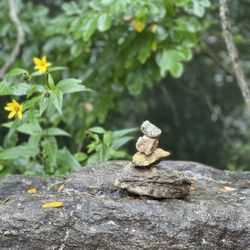
5 years ago
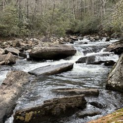
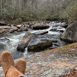
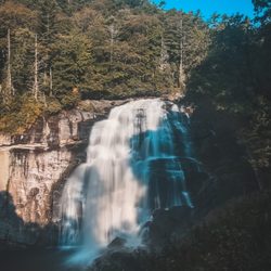
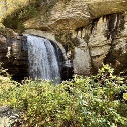
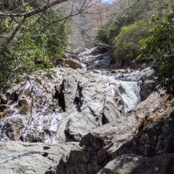
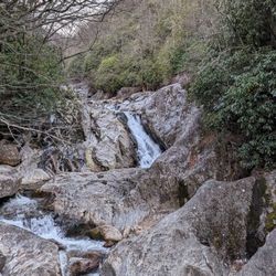
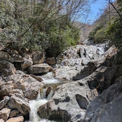
I truly find it unbelievable that I can come into an area and wrack up so many FTR's (first to review) locations. Am I seriously the only yelper who hikes in North Carolina? I'm even more surprised this particular waterfall had no Yelp page! It has a commanding presence that you absolutely cannot miss AND no hike is required to view it, so you would think SOMEONE would have yelped it by now. TOXAWAY FALLS is a gigantic roadside waterfall downstream of the Toxaway Lake Dam. Nearly the entire waterfall is surrounded by either CRAZY STEEP terrain or private property and the only way to really get a head-on shot of the falls is by drone or helicopter! There is a pull-off east of the bridge that give you a decent side view, but doesn't show the depth of the falls like a frontal view would! You can also visit nearby Toxaway Cafe for lunch and an incredible, but distant side view of the falls. It's the best frontal view you're gonna get unless you happen to rent one of the nearby homes facing the falls. While Toxaway Falls looks more like an enormous water slide, topography maps show the falls begin at around 2,953 feet just below the bridge and the overall terrain drops to an elevation of 2,658 in just under a quarter of a mile for a total decline of 295 feet. The main fall drops 80 feet, from 2,920 feet to 2,840 into a pool of water then continues to cascade over significant drops for the next 1,000 feet (about 3.33 football fields). *** [ THINGS TO KNOW ] Total Hiking Distance: 0 miles (roadside) Difficulty: Easy (viewing platform) Creek Crossings: NO Elevation Gain: 0 feet Waterfall Height: about 90 feet initial drop and over 275 total with cascades. Waterfall source: Toxaway River WATERFALL ATTRACTIVENESS - 7 out of 10 TRAIL ATTRACTIVENESS - n/a Access to top of falls: YES Access to base of falls: NOT REALLY Pool of water @ base of Falls: YES Sitting areas @ base: YES if it were accessible RESTROOM FACILITIES: NO PARKING: YES (space for about 8-10 cars) *** [ FINAL THOUGHTS ] TOXAWAY FALLS is a wonder to behold. MASSIVE in size, but difficult to view in all its glory. Still a worthy stop if you happen to be passing through Hogback, NC on Hwy 64. IF you want to see its true size, click on the link below for a drone video of the falls. ENJOY! Drone video: https://www.youtube.com/watch?v=AW-Bj7jSUv0 2021 / 59 read more
 - Hiking Near Me - Hogback, North Carolina")


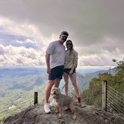
2 years ago
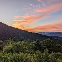
3 years ago
More info about Toxaway Falls
Hwy 64
Hogback, NC 28747
Directions
Hours
Outdoor Amenities


Toxaway Falls - hiking - Updated June 2026
Best of Hogback
People found Toxaway Falls by searching for…
Swimming Holes in Hogback, North Carolina
Hiking Trails With Waterfalls in Hogback, North Carolina
Scenic Overlook in Hogback, North Carolina
Off Road Trails in Hogback, North Carolina
Things to Do in Hogback, North Carolina
River Swimming in Hogback, North Carolina
Swimming Lakes in Hogback, North Carolina
Easy Hikes in Hogback, North Carolina
Beautiful Views in Hogback, North Carolina
Scenic Views in Hogback, North Carolina
Waterfalls in Hogback, North Carolina
Playgrounds in Hogback, North Carolina
Lookout Points in Hogback, North Carolina
View Points in Hogback, North Carolina
Dog Friendly Trails in Hogback, North Carolina
Water Parks for Kids in Hogback, North Carolina
Off Leash Dog Hikes in Hogback, North Carolina
Attractions in Hogback, North Carolina
Swimming in Hogback, North Carolina
To Do in Hogback, North Carolina
Walking Trails in Hogback, North Carolina
Running Trails in Hogback, North Carolina
Browse Nearby
BEST of Hogback, North Carolina Parks near Toxaway Falls
BEST of Hogback, North Carolina Coffee near Toxaway Falls
BEST of Hogback, North Carolina Restaurants near Toxaway Falls
BEST of Hogback, North Carolina Things to Do near Toxaway Falls
BEST of Hogback, North Carolina Campgrounds near Toxaway Falls
BEST of Hogback, North Carolina Scenic View near Toxaway Falls
BEST of Hogback, North Carolina Ski Resorts near Toxaway Falls
BEST of Hogback, North Carolina Breakfast near Toxaway Falls
BEST of Hogback, North Carolina Hot Springs near Toxaway Falls
Browse Brands
Browse Articles
People who viewed Toxaway Falls also viewed
Moore Cove Falls
4 reviews
Secret Falls
3 reviews
Merry Falls
1 review
Thompson River Waterfalls
2 reviews
Turtleback Falls
4 reviews
French Broad Falls & Mill Shoals
2 reviews
Rainbow & Turtleback Falls Trailhead - Gorges State Park
3 reviews
High Falls Trail
4 reviews
Dill and Upper Dill Falls
1 review
Cullasaja Falls
3 reviews