Rainbow & Turtleback Falls Trailhead - Gorges State Park Photos


More like Rainbow & Turtleback Falls Trailhead - Gorges State Park
Recommended Reviews - Rainbow & Turtleback Falls Trailhead - Gorges State Park
Start your review...

Came on a weekday morning, not many cars parked, only went to Rainbow Falls. Pretty short hike to it, although downhill there so uphill on the way back, not too steep. Slightly slippery from rain, lots of dead trees and leaves on the ground. Not a bad hike, would recommend if you're in the area! read more


4 years ago
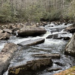
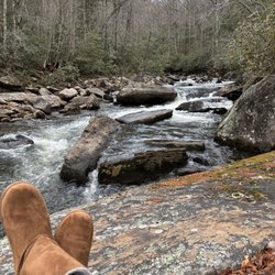
What a fun hike! You hike down to the falls and the hike back up to your car. The falls are amazing. And there are many spots to get off the trail and climb around on the boulders. read more
12 years ago
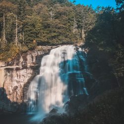
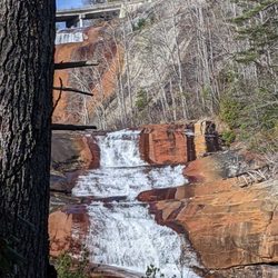
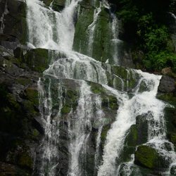
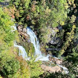
Each year I get older I grow less interested in critiquing the things that are wrong in the world and more interested in highlighting the things that are right in the world. Places like Gorges State Park are a true nature lovers escape where everything feels as right as rain, which is a good thing considering this park receives about 80" of the wet stuff every year. All that rainfall creates rain forest-like conditions and also helps to support a large collection of waterfalls. Currently most of the waterfalls (almost all outside of the parks boundaries) are not easily accessible by way of developed trails. But you're in luck, because three of the most beautiful waterfalls in the area can be reached from the parking area @ Grassy Ridge Road. In total there are more than 20 fabulous waterfalls in this area of NC alone including Whitewater Falls, Glen Falls and Cullasaja Falls. MAP of NC waterfalls: http://www.northcarolinawaterfalls.info/map.html THE WATERFALL COLLECTION This is an easy 2.5 hour drive from Atlanta using I-85 until you cross into South Carolina or you could take the more scenic route using Hwy 441 (I-985). Once you arrive you will find: RAINBOW FALLS truly lives up to it's name. I was indeed delighted to find a visible rainbow at the base of the falls created by all the mist. It's a gorgeous waterfall specimen with a height of 125 feet. Just a day or so prior there were heavy rains, so the volume of water flowing over it's cliffs was amazing. Speaking of the cliffs, they are accessible by continuing along the trail towards Turtleback Falls. You'll get a great view downriver as well as a view of Turtleback Falls further upstream. ---------- TURTLEBACK FALLS is just five additional minutes of hiking from Rainbow Falls. It really does look as though the water is going over the shell of a turtles back. On this day the water level was high and moving extremely fast. So fast that it created a thunderous sound like a plane was flying low overhead as the water from the falls plunged into the pool below. It was AWESOME!!! I was told by other hikers this waterfall is also a popular attraction in the summer for sliding and swimming. I would guess the height to be about 15-20 feet. ---------- DRIFT FALLS is located on private property at the end of the trail, but don't let that discourage you from traveling the additional quarter mile upstream to view it. It's still easily visible even from behind the posted boundaries. They make sure you are aware it is private property with a huge sign stating blah, blah, blah... stay off or we will prosecute to the fullest extent of the law... blah, bah, blah. Follow the fence down to the river and stay behind the signs. It looks like a super cool giant waterslide, which is probably why they don't want people on it. If I lived in the area I'd probably want to slide on this bad mamma-jamma every day!!! The waterfall has an incline of about 70'. ---------- THE VERDICT The hike is approximately 1.5 miles to Rainbow Falls (3 miles round trip or 4 if you hike all the way to Drift). The first half is all downhill until the trail makes a right turn at the river. It gets considerably more difficult along the second half, which is almost entirely uphill. Still, a beautiful series of waterfalls on the mighty Horsepasture River. You can also access Stairway Falls and Windy Falls further down river by turning left at the sign that says 'Raymond Fisher Trail'. Both are considerably more difficult to reach and there is no easy vantage to photograph Windy Falls head on. Here are directions if you feel so inclined to include them in your hiking: http://gowaterfalling.com/waterfalls/stairway.shtml ENJOY LIFE! read more


More info about Rainbow & Turtleback Falls Trailhead - Gorges State Park


Rainbow & Turtleback Falls Trailhead - Gorges State Park - hiking - Updated May 2026
Best of Sapphire
People found Rainbow & Turtleback Falls Trailhead - Gorges State Park by searching for…
Hiking Trails With Waterfalls in Sapphire, NC
Off Road Trails in Sapphire, NC
River Swimming in Sapphire, NC
Beautiful Views in Sapphire, NC
Hiking With Kids in Sapphire, NC
Waterfalls and Swimming Holes in Sapphire, NC
Visitor Centers in Sapphire, NC
Swimming Lakes in Sapphire, NC
Running Trails in Sapphire, NC
Restaurants With a View in Sapphire, NC