Fourth Falls Trailhead Photos


More like Fourth Falls Trailhead
Recommended Reviews - Fourth Falls Trailhead
Start your review...

11 months ago
The fourth falls Hike is extremely diffacult but worth it. loved by me and other teen campers read more


4 years ago
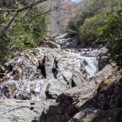
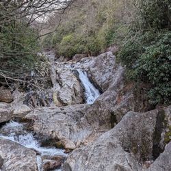
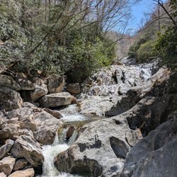
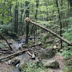
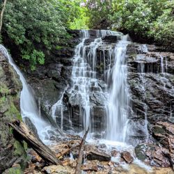
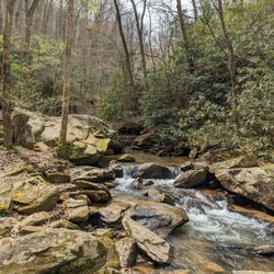
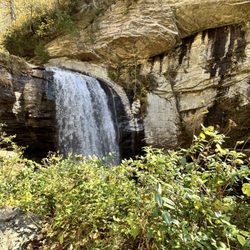
It is important to note FOURTH FALLS is located on the grounds of THE WILDS Christian Camp, which is private property. You can be granted one day permission to hike the falls via the front office. However, if camp or any special events are in session, permission WILL NOT BE GRANTED, so call prior to making plans to visit: (828) 884-7811 Once you receive acceptable hiking dates, you will go to the walk-up window @ the office next to the General Store. Here they will register you, give clearance and a map of where to go to find the trailhead and falls. There are a total of four falls, but this review will specifically concentrate on the last of the four, aptly named FOURTH FALL. [ THE EXPERIENCE ] The waterfall trailhead is located near the basketball courts. Park and head towards the 2nd bridge just beyond the Giant Swing. There will be a set of water cannon on the bridge railing as a reference. BE SURE TO GET A MAP from the office! But even with it, the trail can be difficult to follow because the map was hard to read. There are also signs directing you to the falls at certain intersections, but we found some intersections were not clearly marked. Best to stay left at many of them. We decided to start at Fourth Falls because we were told the connector trail between 4th and 3rd falls was easier to travel up than down. MORE ON THAT LATER!!! I had my sister who is 58 and not a hiker (except when she comes to visit me from Florida) and her husband with me. Typically I don't take her on hikes I have not been on myself, but it just so happened I had already planned this hike when she asked if it was okay to come for a visit the same week. After successfully navigating to the falls and barely avoiding a copperhead snake along the trail, we hung out on the huge boulder taking pics and enjoying its beauty. Fourth Falls is picture perfect. Even in cold months the beautiful green moss remains draped on its stone ledges. We were told the shortcut route to 3rd falls was steep, but not too bad as long as you are fit. Well, that is a gross understatement, because not only should you be fit, but have good upper body strength AND no fear of heights. SERIOUSLY, this trail is not for the faint of heart! I've hiked to over 100 waterfalls, some on really sketchy trails and I have never been in such fear as I was on this trail. Not so much for myself, but for my sister. We started up the shortcut trail and it really didn't seem too bad. This would easily rate as a Class 3 trail because you have to use both hands and feet. The ease of the first part of it was misleading, because it gets harder & steeper, and then outright Class 4 difficult. [ NO TURNING BACK ] At the point we thought the trail ahead was just too difficult, we realized going back the way we came was probably just as hazardous. So we pressed forward hoping the top of the trail would come into view soon. IT DID NOT!!! My sister was beginning to have a panic attack so I talked her through every step, reassured her I was right behind her if she were to lose her footing. Her breathing got more labored so we stopped whenever it was safe to give her a break and blanket her in constant reassurance, while at the same time pointing out the next safe place to stop uphill. I was feeling very confident I could navigate us through safely until we reached a point where the climb became so steep that two very thick ropes had been tethered to a tree far above and out of view. It was here, at this very spot I began to pray for safety & strength to guide my oldest sister out of this predicament. I was terrified because it was THAT STEEP, but I couldn't let her know I was worried! I then instructed her to NOT lean back while using the ropes and be sure her foot was secure each time before taking another step. I matched her step for step, always remaining within full body contact lest she slip & always wrapping the ropes around my arms in case I had to act as a net if her strength failed. I sent her husband ahead to scout the distance to the top and to see if the trail got any more difficult. We didn't see him for almost 8 minutes. When we did make it to the top and back on level ground, she began to cry. We rested for a while and let her gain her composure before beginning the hike back. I did get a chance to see the other three falls via the wooden staircases at each of them, but she'd had enough adventure for one day and opted to stay on the trail until I returned. [ FINAL THOUGHTS ] Kids do these trails weekly, so you would think hazards would be minimal and without my sister, I probably would not have thought it was as bad. But it truly is THEE ONLY HIKE I've ever regretted not fully researching. Then again, I couldn't because it is on private property and there are very few reviews. Still, Fourth Falls is truly beautiful and can be safely reached on the longer route for the less adventurous! Know your capabilities & ENJOY! 2022 / 30 read more


More info about Fourth Falls Trailhead
Wilds Ridge Rd
NC, NC 28712
Directions
Hours
Outdoor Amenities


Fourth Falls Trailhead - hiking - Updated June 2026
Best of NC
People found Fourth Falls Trailhead by searching for…
Basketball Courts in Nc, North Carolina
Campgrounds in Nc, North Carolina
Hiking Trails With Waterfalls in Nc, North Carolina
Things to Do in Nc, North Carolina
Rope Swing in Nc, North Carolina
Waterfalls in Nc, North Carolina
Places to Take Pictures in Nc, North Carolina
Beautiful Views in Nc, North Carolina
View Points in Nc, North Carolina
Lookout Points in Nc, North Carolina
Scenic Overlook in Nc, North Carolina
Playgrounds in Nc, North Carolina
Photo Spots in Nc, North Carolina
Walking Trails in Nc, North Carolina
Christian Camps in Nc, North Carolina
Stairs Workout in Nc, North Carolina
Camping Sites in Nc, North Carolina
Running Trails in Nc, North Carolina
Off Road Trails in Nc, North Carolina
Off Leash Dog Hikes in Nc, North Carolina
Camping Cabins in Nc, North Carolina
Browse Nearby
Browse Brands
Browse Articles
People who viewed Fourth Falls Trailhead also viewed
Gorges State Park
62 reviews
Upper Whitewater Falls
27 reviews
Whiteside Mountain Trail
22 reviews
Triple Falls Trailhead - Dupont State Forest
39 reviews
John's Jump & DEW Falls
1 review
High Falls Trailhead - Dupont State Forest
24 reviews
High Falls - South Trail
5 reviews
Dry Falls
83 reviews
Skinny Dip Falls
6 reviews
High Falls Trail
4 reviews