Soco Falls Photos


More like Soco Falls
Recommended Reviews - Soco Falls
Start your review...

Reviews With Photos

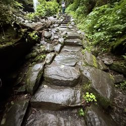
Soco Falls has been updated with a huge parking lot, observation deck at the top (beginning) and second observation deck at the falls with new concrete steps and wood railing. Some trashy, low class dregs of humanity have already vandalised parts of the decks and railing-which were installed and graciously gifted by the Cherokee Reservation Indians, how gross do you have to be to do something so awful? Regardless, it's a beautiful half mile hike each way and the serenity of the falls is so worth it. Hopefully garbage humans dont ruin it for the rest of us to enjoy this magical.place.

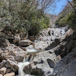
Soco Falls was amazing. This was a very short hike to the waterfall, around 3 minutes. I wouldn't recommend taking any small children since the path is still quite steep. There is an option to climb down to the waterfall and they do have a rope you can hold on to. I recommend good hiking sneakers because some of the rocks are slippery. The view and the whole area are just beautiful and it is worth the stop. It's the easiest hike I've ever done with such a rewarding gem. There are also many people coming and going. Everyone I encountered was friendly.


Very Cool Waterfalls I just realized that I had not done a review of this place and I just visited the mountains in September to see family . I have done this hike a couple of times and it is a short one , but can be a little slippery , so make sure you have the right shoes . They do have some ropes to help guide you and a lookout platform . The parking lot is small , only holds less than 10 cars and you can easily pass it if you don't know where to look . My son did this hike with me in 2010 , so I included our pictures . It is very cool .


A challenging hike down but worth the view. This is NOT located on the Blue Ridge Parkway. It is off the parkway on a road that intersected the parkway called Soco road (aka SR 19 or Wolfetowne road). There is parking right on the edge of this road but the parking is very limited. There is a pullout that fits maybe 10 cars along the side of the road that the falls are on. There are at least 2 ways or levels from which you can see the falls. You proceed down a narrow path leading down to a platform that allows you to see the falls from below the road with a good view of the river and the falls. This path is a narrow dirt path that can be a little tricky but leads to a wooden platform where you can relax, take pictures and enjoy the view. The adventurous can continue down the really steep part that had several ropes to allow the visitors to traverse this part. It is one of the hardest hikes I have ever been on to see any falls in the United States. It is a very nice view from the bottom by the river. Remember that you still have to get back up to get to your car. Overall, I would recommend this set of falls for anyone wanting a pretty view and a unique challenge. Be careful and enjoy!

Stopped here on my way to Cherokee, NC. This is a short hike down to the falls, literally about 80 steps. You can see the falls at the top if you dont wanna take the short hike down. Lovely and breath taking, I will visit again in the Spr/ Summer mths. This is worth a stop for sure. Every yr in the spr I take a WaterFallin Vacay to upper SC, so this was perfect stop along the way! If you havent been to Upper SC you are missing out on beautiful state prks and outdoorsy fun!

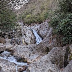
Great short hike in Maggie Valley, NC. Boyfriend and I went up for the weekend to spend some time with his parents in Cherokee and decided on our last day to go out and see a few waterfalls that didn't involve a long hike. This was the second of the two we visited. Right off the highway is where it's located. Pull over and park then head down to the falls. Going down was easy but climbing back up is some work. There are ropes tied to the trees to help the climb back up. This is two waterfalls semi facing each other. The sun was beaming through one of the falls and made it even more beautiful. You're close enough to the falls you can touch the water or get a close up photo with the waterfall on you. We decided to stay dry. If you're looking for something very short, this fall is a great choice. There's also an overlook if you don't want to climb down to the foot of the falls.


In comparison to "Mingo Falls", this was also great. However the trek was a little more difficult than Mingo. If you can climb rocks and don't have an issue with heights than this one is for you. I didn't give it 5 stars because it had the potential for accidents unlike Mingo. There was also ropes that were tied from tree to tree all the way down, just so there is something to hold on to. This fall had many levels and different views, it was very pretty. Many picture taking moments.

Amazing sight! Just steps from the highway. This waterfall was a beautiful sight and a big of a thrill to get to (well, for someone from a larger flat city, this was a "thrill" to "climb" down to). It was so peaceful and gorgeous. The two waterfalls merging was picture perfect. This was the highlight of my visit to North Carolina!
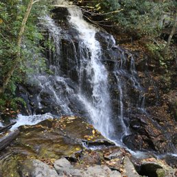
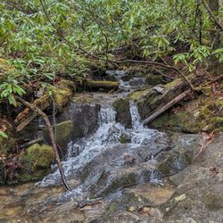
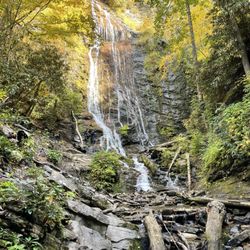
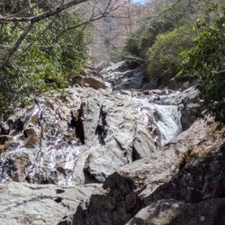
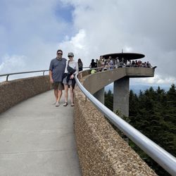
Soco Falls is actually two separate waterfalls (fed by two different rivers) falling in one location. That alone makes it cool and unique, although we do have a couple of waterfalls like that back in Georgia. One being very popular Anna Ruby Falls and the other being Duke's Creek falls. One advantage this waterfall has is location, which is directly next to the roadway. There's no real hiking to speak of so access is fairly easy. But the disadvantage is the trail to the falls or its wooden overlook is not very well-maintained. The trail is steep and slick in areas, so you'll need to use a set of DIY-looking ropes alongside the trail to keep from hurting yourself. Although it hadn't rained in a few days, the trail was very muddy. The two waterfalls are roughly 18 and 35 feet tall respectively. Overall they are worth making a pitstop if you are traveling the Blue Ridge Parkway or visiting the Asheville area. I would not recommend trying to climb down to the base for families with small children or seniors with little upper body strength. They could however make it to the observation deck without the need of ropes. If you are looking for a waterfall CLOSER to Asheville, Catawba Falls is not only more beautiful, it's enormous in size. However, you will have to hike a fairly easy trail about one mile to see it. Enjoy 2018/95

I know, I know...how can I only give four out of five stars to a waterfall?! Because of litter! While this waterfall is gorgeous, its environs are not. Someone needs to clean up the place. One website advised waterfall lovers to descend carefully, as there is a lot of broken glass on the banks and on the adjacent rocks. I don't get it- "Sweetie pie, wouldn't it be romantic if we established this romantic moment/nature rapture/family bonding with the sound of breaking glass?". We missed this spot going toward Cherokee, and almost missed it going the opposite direction. The lookout parking area is sorta small, so it is easy to miss. The sign is blue and small. Leaving Maggie, go past the entrance to the parkway. It is about one and a half miles down the road on the leftside. The walk down was fine, but the walk up. I did not realize how steep it was. There is no railing, so toddlers need to be watched. It is not wheelchair accessible. There is a viewing platform that Brittany and Connor once stood upon and threw their empty beer bottles from, after proclaiming their love with a Sharpie. There are also ropes to help daredevils get closer. This is a climber's mantra- "Wet rock is slippery rock." Remember that. It is loud in the early spring. Very exhilarating and makes you feel alive. The winter is also a good time to see this double fall, as there are no leaves to block the view. The Cherokee used these falls as an entrance to their land and as an ambush base. Feel free to enter and attack litterbugs!

Soco falls is located off the side of the highway in the eastbound lane on the outside of town. Please slow down as your likely to miss it if you're not careful. Once you get there take the hike down the side of the mountain ledge, and you will be rewarded with a serine scene comprising two waterfalls and a canopy of greenery. Difficulty: Not anyone can make it down the side of the cliff. Someone has installed ropes along the side which are very helpful and, in some spots, needed. It can be rather steep at times and somewhat slippery. I would not recommend this hike for anyone with ankle or joint problems, but you don't have to be an expert to participate. Attractions: Two waterfalls converge into a mountain stream to create a beautiful scene. There is also a large wooden observation platform you can climb down to if you don't feel like going all the way down the creekbead. Overall: Short hike down a cliff side that will provide good exercise and breathtaking views. Use caution but not too difficult many families with kids were out there enjoying the falls. read more


I was seeking a waterfall and didn't quite have time to make it to Cherokee and the Great Smoky Mountains, and so located this turn-off a couple of miles off the Blue Ridge Parkway. The parking area is by the road, and the hike down to the falls is short, but of considerable grade. At the end, a platform allows viewing. You can't get anywhere near the falls or take a swim, and it seems like it would be a tough area even if there weren't a thousand signs telling you not to wander off the trail, which is shared with a driveway to some private property. It certainly isn't among the best Western NC waterfalls, but it's a nice site and it's free and open to the public, so not a bad place to stop depending on one's itinerary. read more


Great little path- I believe it's under on mile there. Also dogs on leashes seem to be allowed as well and has its own parking spaces. Great photo ops here. Beautiful place and the walk isn't too far from the parking lot either just very steep so wear good shoes read more


9 months ago
Soco Falls has been updated with a huge parking lot, observation deck at the top (beginning) and second observation deck at the falls with new concrete steps and wood railing. Some trashy, low class dregs of humanity have already vandalised parts of the decks and railing-which were installed and graciously gifted by the Cherokee Reservation Indians, how gross do you have to be to do something so awful? Regardless, it's a beautiful half mile hike each way and the serenity of the falls is so worth it. Hopefully garbage humans dont ruin it for the rest of us to enjoy this magical.place. read more

9 months ago
Soco Falls was amazing. This was a very short hike to the waterfall, around 3 minutes. I wouldn't recommend taking any small children since the path is still quite steep. There is an option to climb down to the waterfall and they do have a rope you can hold on to. I recommend good hiking sneakers because some of the rocks are slippery. The view and the whole area are just beautiful and it is worth the stop. It's the easiest hike I've ever done with such a rewarding gem. There are also many people coming and going. Everyone I encountered was friendly. read more


2 years ago
3 years ago
Beautiful water fall that comes with a challenging path of access. If you have mobility issues or are afraid of heights it's probably best not to go all the way down. But you can enjoy the view from the deck when you get about 1/3 of the way there. Parking lot has limited spots. read more


Very Cool Waterfalls I just realized that I had not done a review of this place and I just visited the mountains in September to see family . I have done this hike a couple of times and it is a short one , but can be a little slippery , so make sure you have the right shoes . They do have some ropes to help guide you and a lookout platform . The parking lot is small , only holds less than 10 cars and you can easily pass it if you don't know where to look . My son did this hike with me in 2010 , so I included our pictures . It is very cool . read more


A short drive from our hotel and literally ON THE SIDE OF THE HIGHWAY! Once I saw people using ropes to get to the bottom I was content to just stay on the platform. It is beautiful, but a bit too risky for me to venture into the steep steep slippery narrow trail. Kudos to those who can! read more


3 years ago
A challenging hike down but worth the view. This is NOT located on the Blue Ridge Parkway. It is off the parkway on a road that intersected the parkway called Soco road (aka SR 19 or Wolfetowne road). There is parking right on the edge of this road but the parking is very limited. There is a pullout that fits maybe 10 cars along the side of the road that the falls are on. There are at least 2 ways or levels from which you can see the falls. You proceed down a narrow path leading down to a platform that allows you to see the falls from below the road with a good view of the river and the falls. This path is a narrow dirt path that can be a little tricky but leads to a wooden platform where you can relax, take pictures and enjoy the view. The adventurous can continue down the really steep part that had several ropes to allow the visitors to traverse this part. It is one of the hardest hikes I have ever been on to see any falls in the United States. It is a very nice view from the bottom by the river. Remember that you still have to get back up to get to your car. Overall, I would recommend this set of falls for anyone wanting a pretty view and a unique challenge. Be careful and enjoy! read more


8 years ago
Stopped here on my way to Cherokee, NC. This is a short hike down to the falls, literally about 80 steps. You can see the falls at the top if you dont wanna take the short hike down. Lovely and breath taking, I will visit again in the Spr/ Summer mths. This is worth a stop for sure. Every yr in the spr I take a WaterFallin Vacay to upper SC, so this was perfect stop along the way! If you havent been to Upper SC you are missing out on beautiful state prks and outdoorsy fun! read more


Great short hike in Maggie Valley, NC. Boyfriend and I went up for the weekend to spend some time with his parents in Cherokee and decided on our last day to go out and see a few waterfalls that didn't involve a long hike. This was the second of the two we visited. Right off the highway is where it's located. Pull over and park then head down to the falls. Going down was easy but climbing back up is some work. There are ropes tied to the trees to help the climb back up. This is two waterfalls semi facing each other. The sun was beaming through one of the falls and made it even more beautiful. You're close enough to the falls you can touch the water or get a close up photo with the waterfall on you. We decided to stay dry. If you're looking for something very short, this fall is a great choice. There's also an overlook if you don't want to climb down to the foot of the falls. read more


2 years ago
7 years ago
In comparison to "Mingo Falls", this was also great. However the trek was a little more difficult than Mingo. If you can climb rocks and don't have an issue with heights than this one is for you. I didn't give it 5 stars because it had the potential for accidents unlike Mingo. There was also ropes that were tied from tree to tree all the way down, just so there is something to hold on to. This fall had many levels and different views, it was very pretty. Many picture taking moments. read more


Amazing sight! Just steps from the highway. This waterfall was a beautiful sight and a big of a thrill to get to (well, for someone from a larger flat city, this was a "thrill" to "climb" down to). It was so peaceful and gorgeous. The two waterfalls merging was picture perfect. This was the highlight of my visit to North Carolina! read more


8 years ago
Soco Falls is actually two separate waterfalls (fed by two different rivers) falling in one location. That alone makes it cool and unique, although we do have a couple of waterfalls like that back in Georgia. One being very popular Anna Ruby Falls and the other being Duke's Creek falls. One advantage this waterfall has is location, which is directly next to the roadway. There's no real hiking to speak of so access is fairly easy. But the disadvantage is the trail to the falls or its wooden overlook is not very well-maintained. The trail is steep and slick in areas, so you'll need to use a set of DIY-looking ropes alongside the trail to keep from hurting yourself. Although it hadn't rained in a few days, the trail was very muddy. The two waterfalls are roughly 18 and 35 feet tall respectively. Overall they are worth making a pitstop if you are traveling the Blue Ridge Parkway or visiting the Asheville area. I would not recommend trying to climb down to the base for families with small children or seniors with little upper body strength. They could however make it to the observation deck without the need of ropes. If you are looking for a waterfall CLOSER to Asheville, Catawba Falls is not only more beautiful, it's enormous in size. However, you will have to hike a fairly easy trail about one mile to see it. Enjoy 2018/95 read more


3 years ago
4 years ago
I know, I know...how can I only give four out of five stars to a waterfall?! Because of litter! While this waterfall is gorgeous, its environs are not. Someone needs to clean up the place. One website advised waterfall lovers to descend carefully, as there is a lot of broken glass on the banks and on the adjacent rocks. I don't get it- "Sweetie pie, wouldn't it be romantic if we established this romantic moment/nature rapture/family bonding with the sound of breaking glass?". We missed this spot going toward Cherokee, and almost missed it going the opposite direction. The lookout parking area is sorta small, so it is easy to miss. The sign is blue and small. Leaving Maggie, go past the entrance to the parkway. It is about one and a half miles down the road on the leftside. The walk down was fine, but the walk up. I did not realize how steep it was. There is no railing, so toddlers need to be watched. It is not wheelchair accessible. There is a viewing platform that Brittany and Connor once stood upon and threw their empty beer bottles from, after proclaiming their love with a Sharpie. There are also ropes to help daredevils get closer. This is a climber's mantra- "Wet rock is slippery rock." Remember that. It is loud in the early spring. Very exhilarating and makes you feel alive. The winter is also a good time to see this double fall, as there are no leaves to block the view. The Cherokee used these falls as an entrance to their land and as an ambush base. Feel free to enter and attack litterbugs! read more

7 years ago
Such a nice view of Mother Nature not too far from the road. You can cross this off your bucket list in 20 minutes. We only stayed at the overlook because we had our 13m with us, but still a nice view. The hike down was a bit terrifying since it's rocky, lots of leaves, roots, etc. I think if there was a railing or a better path, wouldn't have been. The trek is short though, about 2 minutes and it's because you're going slow to watch your footing. Going back up wasn't bad though. I had my 13m on my hip for most of the way up. Hope to make it all the way down one day. read more


5 years ago
4 years ago
Beautiful! Trail is easy until it gets closer to the downward climb to the bottom of the falls. It was muddy and slippery today. There are ropes to guide you down but depending on your age or physical ability it may not be enough to help you down. You'll need sturdy shoes, preferably water shoes. Our 8 and 10 year went down too. They loved it. There is an observation deck if you don't want to go down to the fall. I'm really glad we did it. God's beautiful creation and great family memories! read more


9 years ago
9 years ago
Absolutely beautiful double falls! Great little walk 0.1 mikes from parking, nice overlook or challenging steep hill down to the bottom, great adventure! (Hard to find spot off the road right over the peak of the parkway) read more

7 years ago
Stopped at this waterfall since we didn't feel like doing any real hiking. Not far at all from Maggie Valley and it's a short walk down to the overlook deck. You can continue down to the bottom of the falls if you have some decent shoes and a little arm strength (steep trail, basically have to use the ropes to get back up). Worth a stop for sure! read more

6 years ago
7 years ago
A beautiful, natural, cool spot to relax in the mist and sound of the falls. The trail walk down to the falls is not for everyone but if you are up to it, it is worth the trek down. read more

10 years ago
Between Cherokee and Maggie Valley... One and a half miles toward Cherokee from the Blue Ridge Pkwy intersection. Small pull off is hard to spot. Worth the stop - two waterfalls spill out into one creek... Beautiful, not crowded. Steep steps down to very short walk to observation deck... Then the adventurous can climb down to base of falls. There are ropes there to assist with climb down and back up but we found it easier to maneuver on our own, grabbing rocks when needed... But really not a bad hike down... Do it! read more


9 years ago
Really cool place. We bring our dog and he baby all the time. It's a little hard to get up and down when it has rained. So be careful if you go all the ways down. People alway park like idiots instead of leaving room for other people so you might not be able to find a spot. read more


8 years ago
8 years ago
9 years ago
10 years ago
More info about Soco Falls
Maggie Valley, NC 28751
Directions
Visit Website
http://www.socofalls.com/
Hours
Outdoor Amenities
Ask the Community - Soco Falls
Are dogs permitted in the trails?
Review Highlights - Soco Falls


Why does Yelp recommend reviews?
1 review that is not currently recommended
The reviews below are not factored into the business's overall star rating.
1 year ago
Soco Falls - hiking - Updated June 2026
Best of Maggie Valley
People found Soco Falls by searching for…
Hiking Trails With Waterfalls in Maggie Valley, North Carolina
Parks in Maggie Valley, North Carolina
Things to Do in Maggie Valley, North Carolina
Places to Take Pictures in Maggie Valley, North Carolina
Off Road Trails in Maggie Valley, North Carolina
Dog Friendly Trails in Maggie Valley, North Carolina
Waterfalls and Swimming Holes in Maggie Valley, North Carolina
Scenic Overlook in Maggie Valley, North Carolina
Climbing in Maggie Valley, North Carolina
Waterfalls in Maggie Valley, North Carolina
Walking Trails in Maggie Valley, North Carolina
Photo Spots in Maggie Valley, North Carolina
Easy Hikes in Maggie Valley, North Carolina
Scenic View in Maggie Valley, North Carolina
Hiking With Kids in Maggie Valley, North Carolina
Beautiful Views in Maggie Valley, North Carolina
Hiking Trails Kid Friendly in Maggie Valley, North Carolina
Free Picnic Areas in Maggie Valley, North Carolina
Indoor Rock Climbing for Kids in Maggie Valley, North Carolina
Natural Hot Springs in Maggie Valley, North Carolina
Running Trails in Maggie Valley, North Carolina
Picnic Spots in Maggie Valley, North Carolina
Trending Searches in Maggie Valley, NC
Black Owned Nail Salons near Soco Falls
Dog Friendly Trails near Soco Falls
Jet Ski Rental near Soco Falls
Off Road Trails near Soco Falls
Outdoor Activities near Soco Falls
Places To Walk Around near Soco Falls
River Swimming near Soco Falls
Scenic Night View near Soco Falls
Scenic Overlook near Soco Falls
Secluded Spots near Soco Falls
Strawberry Picking near Soco Falls
Swimming Holes near Soco Falls
Browse Articles
Browse Nearby
Browse Brands
Related Searches in Maggie Valley, NC
Affordable Kayak Rental Services in Maggie Valley, North Carolina
Best Fishing Locations and Guides in Maggie Valley, North Carolina
Best Fun Things to Do in Maggie Valley, North Carolina
Best Gym With Sauna Amenities in Maggie Valley, North Carolina
Best Gymnastics for Kids Activities in Maggie Valley, North Carolina
Best Iyengar Yoga Classes and Studios in Maggie Valley, North Carolina
Best Places for Horseback Riding in Maggie Valley, North Carolina
Best Rock Climbing Gyms to Try in Maggie Valley, North Carolina
Best Spinning Classes Offered in Maggie Valley, North Carolina
Best Waterfalls and Swimming Holes in Maggie Valley, North Carolina
Browse Yoga Classes and Schedules in Maggie Valley, North Carolina
Check Out Off Road Trails in Maggie Valley, North Carolina
Discover Dog Friendly Trails to Explore in Maggie Valley, North Carolina
Discover Great Fitness Classes Available in Maggie Valley, North Carolina
Discover Outdoor Gym Facilities in Maggie Valley, North Carolina
Discover Popular Ropes Course Options in Maggie Valley, North Carolina
Discover Powerlifting Gym Near Maggie Valley, North Carolina
Discover Scenic Mountain Bike Trails Near Maggie Valley, North Carolina
Discover Scenic Waterfall Spots in Maggie Valley, North Carolina
Discover Top State Parks to Visit in Maggie Valley, North Carolina
Discover Top Yoga Options and Studios in Maggie Valley, North Carolina
Discover a Hiking Trail in Maggie Valley, North Carolina
Discover the Best Night Hike Trails in Maggie Valley, North Carolina
Dog-Friendly Hikes With Dogs in Maggie Valley, North Carolina
Effective Strength Training Near Maggie Valley, North Carolina
Enjoy Camping Adventures Around Maggie Valley, North Carolina
Enjoy Exciting Mountain Biking Adventures in Maggie Valley, North Carolina
Enjoy Kayaking Adventures in Maggie Valley, North Carolina
Enjoy Tent Camping Spots Around Maggie Valley, North Carolina
Enjoy a Beautiful Waterfall Hike in Maggie Valley, North Carolina
Enjoy the Best Picnic Spots and Ideas in Maggie Valley, North Carolina
Enjoy the Best Tubing Experiences in Maggie Valley, North Carolina
Enjoy the Best Walking Trails in Maggie Valley, North Carolina
Exciting Cliff Jumping Spots in Maggie Valley, North Carolina
Exciting Laser Tag Games and Venues in Maggie Valley, North Carolina
Experience Thrilling White Water Rafting in Maggie Valley, North Carolina
Explore Beautiful Parks and Green Spaces in Maggie Valley, North Carolina
Explore Boxing Classes for Fitness and Skill in Maggie Valley, North Carolina
Explore Fun Activities to Do in Maggie Valley, North Carolina
Explore Gyms With Pool Access in Maggie Valley, North Carolina
Explore Indoor Tennis Courts in Maggie Valley, North Carolina
Explore Martial Arts Options in Maggie Valley, North Carolina
Explore Nature Spots Around Maggie Valley, North Carolina
Explore Popular Campgrounds Near Maggie Valley, North Carolina
Explore Top Trampoline Parks in Maggie Valley, North Carolina
Explore Weight Lifting Options in Maggie Valley, North Carolina
Explore Zumba Classes Near Maggie Valley, North Carolina
Explore the Best Barre Classes Available in Maggie Valley, North Carolina
Explore the Best Beach Spots in Maggie Valley, North Carolina
Explore the Best Boating Spots in Maggie Valley, North Carolina