Cancel

    Open app

    Search

    Looking Glass Rock Overlook

    4.5 (6 reviews)

    Looking Glass Rock Overlook Photos

    Recommended Reviews - Looking Glass Rock Overlook

    Your trust is our priority, so businesses can't pay to alter or remove their reviews. Learn more about reviews.
    Yelp app icon
    Browse more easily on the app
    Review Feed Illustration

    Reviews With Photos

    Tim B.

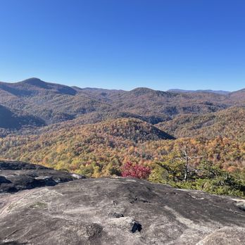
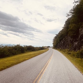
    The drive isn't too bad - less enjoyable than the Great Smokey Mountain Trail. We did see a small heard of elk on our way from Waynesville - which was pretty neat. The area is clean and pretty natural. You'll pass a small shop and and local inn on our way.

    The view from the top of the rock

    See all

    5 years ago

    Helpful 5
    Thanks 0
    Love this 6
    Oh no 0
    Photo of Richard R.
    4995
    1585
    26080

    5 years ago

    Helpful 116
    Thanks 0
    Love this 114
    Oh no 0

    5 years ago

    Helpful 2
    Thanks 0
    Love this 2
    Oh no 0
    Photo of Tim B.
    0
    13
    28

    3 years ago

    Helpful 0
    Thanks 0
    Love this 0
    Oh no 0

    4 years ago

    Helpful 0
    Thanks 0
    Love this 1
    Oh no 0

    5 years ago

    Helpful 1
    Thanks 0
    Love this 0
    Oh no 0

    Ask the Community - Looking Glass Rock Overlook

    Verify this business for free

    People searched for Hiking 362 times last month within 15 miles of this business.

    Verify this business

    Purchase Knob - Trail signs

    Purchase Knob

    5.0(2 reviews)
    14.7 mi

    This has been our favourite walk forever. Do not let the couple of bad characters hinder you from…read morethis beautiful hike, because getting to the top is its own reward with sheer beauty. This property was donated to the state park and open to all. Very clean and well-kept trails, dog friendly, and a nice place to rest and relax, including restrooms at the science centre.

    I discovered this place through my daughter. She has gone here twice- once through her middle…read moreschool, and once through a local camp. She raved about it, and we finally got a chance to check it out. So happy we did! Purchase Knob was generously donated by the McNeil-Gilmore family to Great Smoky Mountains National Park. It is 535 acres of land that rises ultimately to 5,086 feet at the knob. In the meadow below the knob, at 4,850 feet, there are two buildings housing offices, a lab, a classroom for fifty students, and housing for up to eight scientists. Views are 180 degrees. You can hit the Cataloochee Divide Trail here, too. A refurbished cabin originally from the 1870s is nearby, which I will get to in a bit. When you get to the park, you will be blocked by a gate with a sign to the left identifying the park. It is open once in a while for scheduled visits/field trip students. It is easy to get your vehicle locked within the park. (People cannot get locked in.) Park your car on the sides of the road. Just walk around the gate if it is locked. Bring water, and a jacket in the spring or fall. The 2.5 mile round trip trail is basically a wide, dirt road that will eventually lead up to the main buildings. It is well maintained. When you get a glimpse of the building at the top, you will also see a grass trail leading upwards. I would take that trail. It is a shortcut. If you like to walk, just keep going, and the road will eventually lead to the building as well. On the way up, you will see many types of wildflowers. We heard (up) and spotted a hawk (down). I got a photo of nightshade, all the while with my body centimeters from a hidden cliff edge. Be careful on grassy edges! The open areas and tree-filled areas were of equal beauty. In early September I saw purples, greens, grays, and yellows, all framed by a clear blue sky graced by fluffy clouds. Your soul will take this in, and it will hold on to it. When we got to the top, we relaxed. We did not go to the knob proper. We used the very clean bathrooms, and laid down in the field right in front of the buildings. There is a water fountain. You are allowed on the deck, but not in the buildings unless you are with a scheduled group. There are picnic tables grouped close together, and bear-proof trashcans and recycling bins. You can check out the outside of the weather station that is a bit away. I would not traipse around the adjacent fields. I saw tagged plants and left that area so that we would not screw up any data. If you decide to go to the actual knob, you have to blaze your own trail. As of two days ago, the footbridge leading to Cataloochee was out. There is a sign warning of that; be careful crossing creeks. Anyway, that trail is easy to find; just look for signs. Check out the bulletin board for lists of the types of birds and butterflies that you can see there. I saw (possibly) a Cloudless skipper. It was fluorescent yellow! My first. To get down to the restored Ferguson cabin, just leave via the "grass carpet" trail. Make an obvious right and hitch your horse, or kids. This right will lead you to the cabin. The Fergusons were the first farmers to have an elevated farm. Their apples are still there. Do not pick anything. Do not get in the boar trap. Do not get near bears. Do not bother the cow spirits. Call to make sure horses are indeed still allowed. Bears and boars can hurt you. We leave all snacks in the car. You never know. Call the general number to see if bear activity is intense before going to this park. Middle school and up teachers, call this number to schedule a visit: 828-926-6251. This park welcomes wimpy and tough hikers mid-March through November. Call if you have a desire to hike in the deep winter. Remember to check out the Purchase Knob WebCam online for weather and views. To get to this park, take Exit 20, stay on 276 South for five miles. Get on Hemphill Road and stay on Hemphill Road for four miles. This review is dedicated to my daughter Sophie, a quick, beautiful trailblazer.

    Photos
    Purchase Knob
    Purchase Knob - Furbaby friendly

    Furbaby friendly

    Purchase Knob - Coral mushroom. Fall 2017.

    See all

    Coral mushroom. Fall 2017.

    Skinny Dip Falls

    Skinny Dip Falls

    5.0(6 reviews)
    0.0 mi

    Love this hike so much. I do have to say it was quite shocking To go back after not visiting for h…read moreyears- there has been a lot of maintenance since the storms washed the bridge out last year (!?). Still a beauty though. The parking lot has space for about 15 but you can park on the side of the road if you need. It's pretty safe and spacious. This hike is great for everyone- small incline and easy 1 mile ish to a fall. Where you can swim if you wish (maybe not skinny dip though- it's pretty popular). Dog friendly. Some rocks at the end but there are alternative ways and it's not unsafe or unstable. Lots of roots but overall the pathways are lovely and wide. . You can also see the semi famous wnc dragon tree :)

    SKINNY DIP FALLS is by no means a sizable waterfall and if I'm being honest, I thought it would be…read moremuch larger and more impressive! However, it is indeed a gorgeous waterfall located in a beautiful & scenic section of the forest. The trailhead to the falls is directly across the Blue Ridge Parkway from LOOKING GLASS ROCK OVERLOOK. It is a white blazed trail and although it tends to fork off to smaller, well established side trails, the main trail is pretty obvious. When in doubt, stay on the largest/widest path. The trail starts off fairly level with only minimal ups and downs, but just past the DRAGON TREE begins a significant downhill descent as it drops from an elevation of 4505 feet to 4,325 feet at the bridge. That's 180 feet in just under 1/3rd of a mile. The trail itself is a rocky and heavily-rooted one, so it is important to watch your step considering all the natural tripping hazards. Still, despite the return elevation gain, trail tripping hazards and its small size in comparison to other nearby waterfalls, it is truly a hidden beauty worthy of any waterfall hunters list! It is located on a creek known as Yellowstone Prong and it won't be hard to see where it gets its name. The stones and boulders surrounding the falls are GORGEOUS in color as collectively they take on a golden hue. It is in fact one of the prettiest natural stone settings I've seen in all my waterfall travels. There are plenty of large boulders to sit and enjoy the falls as well as different levels of the falls for everyone to have their own space. Those that climb further to the top will find tranquil hot tub sized pools of turquoise clear water at each level. Towards the bottom is the most significant fall (about 12 feet) that immediately flows into a V-shaped rock channel cutting under the bridge and into two more pools of ultra-clear water! It is a wonderfully flat area great for smaller children to safely explore, under parental supervision of course. *** PRO TIP - I didn't know it during my visit, but even further up the creek is Yellowstone Falls. I'm not absolutely certain you can reach it by climbing from Skinny Dip Falls, but online reports say it IS possible. However, the elevation gains to get to those falls is around 300 feet according to topography maps and would require some bushwhacking to reach Yellowstone Falls from Skinny Dip Falls. But if you are the adventurous type, photos definitely show a very worthy and attractive waterfall awaits. *** [ THINGS TO KNOW ] Total Hiking Distance: 1 mile (round trip) Difficulty: Easy on the way, but a tad more difficult on the return Creek Crossings: YES (bridged) Elevation Gain: 200 feet (if you climb the falls) ~ parking elevation: 4,490' ~ base of falls elevation: 4,325' Waterfall Height: around 35 feet overall counting all the tiers Waterfall source: Yellowstone Prong WATERFALL ATTRACTIVENESS - 8 out of 10 TRAIL ATTRACTIVENESS - 6 out of 10 Access to top of falls: YES Access to base of falls: YES Pool of water @ base of Falls: YES (many) Sitting areas @ base: YES RESTROOM FACILITIES: NO PARKING: YES (space for about 20-25 cars) *** [ WHY IS THIS WATERFALL SO WONDERFUL ] A) Parking for the trailhead is at one of the most beautiful overlooks on the parkway (Looking Glass Rock). B) While the trail is a calorie burner on the return, it is not a long hike and bridges, as well as man-made steps, make it useful to most any hiking ability. C) Bring swimwear and picnic supplies because you're gonna want to stay a while. D) Levels make it possible for many families to have their OWN SECTION of the falls to enjoy, making it one of the easiest waterfalls to practice social distancing when crowds are low. E) The stones, water clarity, and overall venue are simply fabulous. F) Family & pet friendly! *** [ FINAL THOUGHTS ] SKINNY DIP FALLS has been on my radar for over a decade, so I am happy to finally cross it off my list! But make no mistake about it, I will be back again in the summer to enjoy its beauty with the younger members of our family. RICHARD RECOMMENDED :-) 2021 / 63

    Photos
    Skinny Dip Falls
    Skinny Dip Falls
    Skinny Dip Falls

    See all

    Black Balsam Knob

    Black Balsam Knob

    4.7(3 reviews)
    2.9 mi

    On multiple trips through the area, I hadn't taken this particular turnoff. The better known area,…read moreGraveyard Fields, lies below. This area is apparently under the Forest Service rather than the National Park service. The road dead ends in a small parking area, but most people were haphazardly parked on the side of the road. It was a bit dodgy and unclear where you were actually supposed to park, the road quality was not great, and the bathrooms would leave one wondering whether perhaps finding a secluded spot in the wilderness was a better bet. Not that well maintained, though it is certainly fair to acknowledge the difficulty of working in this remote environment. But once you're on the trail, it's all good. The trail cuts through a fascinating terrain. Signs strongly advise you not to tread off, and it feels as if the trail cuts through a layer of peat that would engulf you if you tried in some areas. I managed a loop through two peaks and took the easier route back with fewer views called the Ivestor trail (not investor). It was a great experience to look down over terrain which I've been through before, and that loop is a fairly exhausting, rocky five miles. Of course, there are always linkages to other trail systems in this area, so you can hike as little or as much as you want.

    Love love this hike. It's been a staple of mine for ages. Get out there and hike it- it's perfect…read morefor all ages and levels. Parking can be dicey so make sure to go an off time if you can (ex-early or on weekdays). You will most likely park on the side of the road but people drive slowly so it's not too bad or dodgy. There are two hikes in this area- sams knob (where the parking lot is) and Black Balsam (what I am reviewing).Honestly you will get great views at any of the hikes around as they're similar. This one had an entrance/ start point right off the road. There is a sign. This hike is about 2 miles total. You have a bit of an incline at first but it's not bad. Lots of space and clean paths. When you get to the top the views are awesome. Clouds? Just wait 5 mins. They move fast :$

    Photos
    Black Balsam Knob
    Black Balsam Knob
    Black Balsam Knob

    See all

    Soco Falls

    Soco Falls

    4.7(39 reviews)
    22.6 mi

    Soco Falls is absolutely worth the stop if you're driving through the area. The waterfall is…read morebeautiful, and the photos honestly don't do it justice. That said... don't let the short hike fool you! The walk down isn't bad--it's the climb back up that will definitely remind you whether you've been keeping up with your cardio. Thankfully, there are handrails and benches along the trail because I absolutely took advantage of them on the way back. I thought I was in decent shape... the mountain quickly humbled me! My advice: wear good hiking shoes, bring water, and if you have a walking stick, use it. A neck fan isn't a bad idea either during the warmer months. Just because you see people tackling the trail in Crocs or flip-flops doesn't mean it's a good idea. If you're adventurous, there is a way to get down to the base of the falls, where people were swimming, but we admired it from the overlook instead. The surrounding mountain views are beautiful as well, making it an easy stop even if you're just passing through. If you're in the Bryson City/Cherokee area, don't skip Soco Falls. Just come prepared, take your time, and enjoy one of the prettiest waterfalls in Western North Carolina.

    I was seeking a waterfall and didn't quite have time to make it to Cherokee and the Great Smoky…read moreMountains, and so located this turn-off a couple of miles off the Blue Ridge Parkway. The parking area is by the road, and the hike down to the falls is short, but of considerable grade. At the end, a platform allows viewing. You can't get anywhere near the falls or take a swim, and it seems like it would be a tough area even if there weren't a thousand signs telling you not to wander off the trail, which is shared with a driveway to some private property. It certainly isn't among the best Western NC waterfalls, but it's a nice site and it's free and open to the public, so not a bad place to stop depending on one's itinerary.

    Photos
    Soco Falls - Trail to the waterfall

    Trail to the waterfall

    Soco Falls
    Soco Falls

    See all

    Graveyard Fields

    Graveyard Fields

    4.7(14 reviews)
    1.2 mi

    My kind of hike! It wasn't too difficult when it came to physical exertion, but lots of rocks to…read morewalk around. I was thankful for my hiking shoes although I did see many people out there in sandals. Personally I wouldn't have been able to make it in sandals, but kudos to them. The reward was a beautiful waterfall at the end where my husband and I sat around for 30 min or so enjoying both the beautiful view and weather. The trail wasn't marked perfectly, but there are plenty of people to ask on the way where to go so we made it there and back with no issues. We moved at a steady pace and each way took us about 45 min. The parking lot was pretty full when we got there (around 11am on a week day), but people were coming and going so we found a spot. I got off the hike hungry for lunch so we stopped nearby at a store where we were able to grab a snack, but not too much to eat in the area so eat before or bring something with you.

    I gave this 5 stars because if it wasn't raining it would have been. Unfortunately it was rainy and…read moresome muddy areas, but beautiful water ways, well marked trails and got to peep some fall foliage. This is a free stop on the Blue Ridge Parkway. They also have restrooms and are pet friendly, which is always a plus in my book. The trails are a little rough with roots and some rocks, also some stairs, which in the higher elevation were kicking my butt, but if you're a regular hiker you'll be all set.

    Photos
    Graveyard Fields
    Graveyard Fields
    Graveyard Fields

    See all

    High Falls Covered Bridge - High Falls Covered Bridge, Cedar Mountain

    High Falls Covered Bridge

    5.0(2 reviews)
    15.1 mi

    Big thanks to Richard R. for adding this one that did not come up in the usual searches and yet, it…read morewas the main reason I passed through the DuPont Forest. I love bridges and I love covered bridges even more! And wow, thanks for the amazing writeup of all the drama on this property that was an eye-opener. I parked the van at the High Falls Trailhead (there are restrooms and even a wifi here!) and made my way along the trail to the bridge. It's about 0.75 of a mile on a path through the woods. I am apparently not as delicious as usual as I earned zero mosquito bites despite sweating a lot in the humidity. I'd call this walk "easy plus." The bridge itself is impressive and quite modern. And I would suggest not missing the nearby Falls though I was simply too tired and it was getting too late for me. I'll need to plan better next time! The walk back was much easier as I opted to take the gravel road that is easy and smooth, but only open for emergency vehicles and the forest rangers. I would rate the hike as "easy" for 0.6 miles though not wheelchairable. You can ask the rangers for access by vehicle for handicapped but they're only open regular hours. [Review 20030 overall - 3463 in North Carolina - 1005 of 2023.]

    High Falls Covered Bridge (also known as Buck Forest Covered Bridge) is one of my favorite bridges…read morein the Southern United States. It is a modern structure that has an interesting history. It is an example of the power of the people versus the dollar power of a developer. HISTORY In 1999, Sterling Diagnostic Imaging decided to sell their interest in the land that holds Triple Falls and High Falls, two of the most gorgeous waterfalls you will ever visit this side of the Mississippi. For reasons still unknown, the company decided to use an unusual bidding method by choosing to keep the bidding private and secretive. The State offered up a bid in efforts to save the land for public use, but Sterling announced a developer by the name of Jim Anthony won with a bid of 6.35 million. The developer initially announced in the Hendersonville Times News that he had no plans to develop the land, but instead wanted to use it as a private retreat. However, it soon became apparent Anthony was indeed planning a massive upscale gated community. The fact that the deed he purchased from Sterling Diagnostics stating the land could not be used for residential purposes at the Transylvania Courthouse did not seem to matter. It was later discovered the complex legal agreement between the two was unenforceable and the battle began between the state and Anthony. Anthony proceeded to begin building the roads and this gorgeous covered bridge as part of his planned community, but thankfully he was ultimately defeated. On October 23, 2000 Governor Jim Hunt and the Council of State unanimously voted to invoke eminent domain on the tract of land owned by developer Anthony. In many ways Anthony still won big, because the State paid him 24.5 million dollars in an out of court settlement. WOW! The Falls opened to the public on December 17, 2000. Since then, the entire 2200 acres has been integrated into Dupont State Forest. [History Reference: Romantic Asheville - "How Dupont State Forest was saved"] FINAL THOUGHTS Aside from being one of the most beautiful covered bridges you will ever see, it also is part of a trail system that includes arguably the most beautiful waterfalls in the South. If that is not enough of a reason to come here, let me give you movie fans one more reason. Many scenes from the 1st Hunger Games were filmed right here in this forest. The scene were Katniss finds Peeta camouflaged in the ground at the waterfall is located on the second tier of Triple Falls... just a half mile downstream of High Falls Covered Bridge. Movie scene: https://www.youtube.com/watch?v=UxvyMiwhJWw Year Built: 2000 Obvious materials: Wood, stone, concrete Spans over: Little River at the top of High Falls Location: Dupont State Forest @ Buck Forest Road

    Photos
    High Falls Covered Bridge - High Falls Covered Bridge, Cedar Mountain

    High Falls Covered Bridge, Cedar Mountain

    High Falls Covered Bridge - High Falls Covered Bridge, Cedar Mountain

    High Falls Covered Bridge, Cedar Mountain

    High Falls Covered Bridge - Lots of riders use the trails, so your chances of seeing a group on horseback is pretty good!

    See all

    Lots of riders use the trails, so your chances of seeing a group on horseback is pretty good!

    Looking Glass Rock Overlook - hiking - Updated October 2026

    Loading...
    Loading...
    Loading...