Twin Falls Photos


More like Twin Falls
Recommended Reviews - Twin Falls
Start your review...

Reviews With Photos

A new favorite!! For a short hike, it's an amazing reward to witness this beautiful array of waterfalls. I was only expecting two waterfalls, as the name would suggest, but I felt like I got the "BAZINGA!!" from Sheldon cuz there's more than two and different types and sizes. I am not eloquent enough to give a proper description of how amazing and wonderful this piece of natural creation is. I hope the photos I uploaded somewhat conveys, even just a little, of how awesome this place is. Thank you, Richard & Dani, for allowing us to join you and guiding us to this wonderful place and having an amazing day of viewing/enjoying Fall in the mountains and the wonderful colors the season brings.

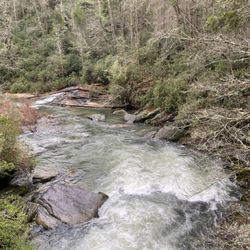
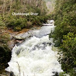
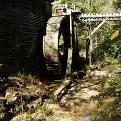
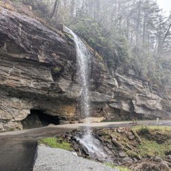
Some falls are grueling trails that offer a great pay off. Twin Falls Trailhead offers a pretty easy trail and shows you a phenomenal view of, well, twin falls! Twin Falls (also Reedy Cove falls....OR Eastatoe falls) is easy to get to, a joy to walk along the trail and again, the payoff is well worth! This trail clocks in at 0.3 miles, and since this is an in and out trail, you're looking at a round trip at just over a half mile. Starting from a small gravel parking lot, along the trail you'll fnd several photo opportunities at large boulders resting in running waters and a small water wheel that I don't know the history behind but man it's sure photogenic! This trail ends at a nice wooden viewing deck which is covered, has plenty of room for seating and allows a great view of the falls, which are definitely worth the drive. Taken from the website (https://discoversouthcarolina.com/products/25550) "The left and larger of the falls pitches from a height of 75 feet over a massive slab of granite, while the right side manages a short drop onto another chunk of stone and then slides down a 45 degree slope before rejoining its twin" During the hike we saw families there with small children, dogs and all were moving at a good pace, so bring your family for this one. Twin falls is probably not a spot I would drive all the way from Atlanta for with no other destination in mind (we visited from ATL), but if you'll be anywhere close to the area and you want to plug this in to accompany a lunch break, break up a long road trip or include this as a trail companion to a series of hikes for the day (or whatever reason really), this is really worth it!

If you're out hunting waterfalls in the Carolina's, put this one on your list. Two side by side waterfalls: One is a straight shelf drop and the other, a cascading beauty. Twin Falls or Reedy Cove Falls or Eastatoe Falls (depending on who you ask) is easily accessible from the trailhead making it a perfect hike for families with young children. Along the way you will find plenty of photo opportunities as the Reedy Cove river travels side by side with the trail and creates several cascades. You will also happen upon an old hand made water wheel while exploring the trail. I can think of no logical reason for it's location, but it's a fun find nonetheless. There is a hand carved sign that reads "In Loving Memory of Buck Hinkle", but as hard as I've tried, I can't seem to locate any information about Mr. Buck. A very cool tree that started in the crack of a boulder and whose roots grew around the boulder is also an interesting sight. http://www.yelp.com/biz_photos/twin-falls-trailhead-a-k-a-reedy-cove-falls-pickens-county?select=r2M5j5q1pecqyyWmh8Sxxw#EmKnEeoxGB3EyT7cTcZYvQ The trail will lead you to a wooden overlook or, if you have a more adventurous spirit, you can climb over the rail and find a safe path to the base of the falls. Let me just tell you that this sucker is the slippery slope yo' mamma warned you about. I'm so happy none of you were there to witness my impromptu electric slide down a section of these slick stones as I did my best not to fall. I managed to stay on my feet but landed in a soft grassy area ankle deep in mud. My oldest son wasn't so lucky. A trip down a slick (yet rough) stone surface does a number on the backside! It was epic! We laughed about both our slides all the way back to the car. http://www.yelp.com/biz_photos/sassafras-mountain-sunset?select=Rdsqt4u13nx4h6dJkJI-AQ#Rdsqt4u13nx4h6dJkJI-AQ If you come in the fall, the road you travel is next to the base of the mountain range. http://www.yelp.com/biz_photos/twin-falls-trailhead-a-k-a-reedy-cove-falls-pickens-county?userid=JjXuiru1_ONzDkYVrHN0aw#r2M5j5q1pecqyyWmh8Sxxw The fall colors are off the chart beautiful during the peak of the season. Our adventure started here and took us to Sassafras Mountain (the highest peak in South Carolina), Pearson's Falls, Campbell's covered bridge and Poinsett bridge. Enjoy! --------------- - - - - - Trail Location: Eastatoe Gap Roundtrip Length: .5 Miles Elevation Gain: unknown Trail Difficulty Rating: Easy Waterfall Height: 75' Yelp100 [42]

6 months ago
Nice hike easy walk very pretty.. we were trying to do the upper part of the falls but still had a lot of trees down blocking too much of the walking path no way around read more


3 years ago
Short walk from the parking area, great spots for dogs to splash around. Be ready for slick rocks, but otherwise not a strenuous hike. This is a great place to view the falls from the trail or the platform, take a selfie, and be still with the rushing water. For a more strenuous hike, take a short drive to the trail head for the upper trail to the top of the falls. read more
2 years ago
Beautiful, big falls. Hike to observation deck below the falls was short with a couple of tight spots. 3 photographers were there when we showed up. Dogs loved it. Didn't have time to take the longer hike to the top. We'll do that at a later date. read more

A new favorite!! For a short hike, it's an amazing reward to witness this beautiful array of waterfalls. I was only expecting two waterfalls, as the name would suggest, but I felt like I got the "BAZINGA!!" from Sheldon cuz there's more than two and different types and sizes. I am not eloquent enough to give a proper description of how amazing and wonderful this piece of natural creation is. I hope the photos I uploaded somewhat conveys, even just a little, of how awesome this place is. Thank you, Richard & Dani, for allowing us to join you and guiding us to this wonderful place and having an amazing day of viewing/enjoying Fall in the mountains and the wonderful colors the season brings. read more


7 years ago
Some falls are grueling trails that offer a great pay off. Twin Falls Trailhead offers a pretty easy trail and shows you a phenomenal view of, well, twin falls! Twin Falls (also Reedy Cove falls....OR Eastatoe falls) is easy to get to, a joy to walk along the trail and again, the payoff is well worth! This trail clocks in at 0.3 miles, and since this is an in and out trail, you're looking at a round trip at just over a half mile. Starting from a small gravel parking lot, along the trail you'll fnd several photo opportunities at large boulders resting in running waters and a small water wheel that I don't know the history behind but man it's sure photogenic! This trail ends at a nice wooden viewing deck which is covered, has plenty of room for seating and allows a great view of the falls, which are definitely worth the drive. Taken from the website (https://discoversouthcarolina.com/products/25550) "The left and larger of the falls pitches from a height of 75 feet over a massive slab of granite, while the right side manages a short drop onto another chunk of stone and then slides down a 45 degree slope before rejoining its twin" During the hike we saw families there with small children, dogs and all were moving at a good pace, so bring your family for this one. Twin falls is probably not a spot I would drive all the way from Atlanta for with no other destination in mind (we visited from ATL), but if you'll be anywhere close to the area and you want to plug this in to accompany a lunch break, break up a long road trip or include this as a trail companion to a series of hikes for the day (or whatever reason really), this is really worth it! read more


 of the twin falls - Landmarks & Historical Buildings Near Me - Pickens, South Carolina")

6 years ago
6 years ago
13 years ago
If you're out hunting waterfalls in the Carolina's, put this one on your list. Two side by side waterfalls: One is a straight shelf drop and the other, a cascading beauty. Twin Falls or Reedy Cove Falls or Eastatoe Falls (depending on who you ask) is easily accessible from the trailhead making it a perfect hike for families with young children. Along the way you will find plenty of photo opportunities as the Reedy Cove river travels side by side with the trail and creates several cascades. You will also happen upon an old hand made water wheel while exploring the trail. I can think of no logical reason for it's location, but it's a fun find nonetheless. There is a hand carved sign that reads "In Loving Memory of Buck Hinkle", but as hard as I've tried, I can't seem to locate any information about Mr. Buck. A very cool tree that started in the crack of a boulder and whose roots grew around the boulder is also an interesting sight. http://www.yelp.com/biz_photos/twin-falls-trailhead-a-k-a-reedy-cove-falls-pickens-county?select=r2M5j5q1pecqyyWmh8Sxxw#EmKnEeoxGB3EyT7cTcZYvQ The trail will lead you to a wooden overlook or, if you have a more adventurous spirit, you can climb over the rail and find a safe path to the base of the falls. Let me just tell you that this sucker is the slippery slope yo' mamma warned you about. I'm so happy none of you were there to witness my impromptu electric slide down a section of these slick stones as I did my best not to fall. I managed to stay on my feet but landed in a soft grassy area ankle deep in mud. My oldest son wasn't so lucky. A trip down a slick (yet rough) stone surface does a number on the backside! It was epic! We laughed about both our slides all the way back to the car. http://www.yelp.com/biz_photos/sassafras-mountain-sunset?select=Rdsqt4u13nx4h6dJkJI-AQ#Rdsqt4u13nx4h6dJkJI-AQ If you come in the fall, the road you travel is next to the base of the mountain range. http://www.yelp.com/biz_photos/twin-falls-trailhead-a-k-a-reedy-cove-falls-pickens-county?userid=JjXuiru1_ONzDkYVrHN0aw#r2M5j5q1pecqyyWmh8Sxxw The fall colors are off the chart beautiful during the peak of the season. Our adventure started here and took us to Sassafras Mountain (the highest peak in South Carolina), Pearson's Falls, Campbell's covered bridge and Poinsett bridge. Enjoy! --------------- - - - - - Trail Location: Eastatoe Gap Roundtrip Length: .5 Miles Elevation Gain: unknown Trail Difficulty Rating: Easy Waterfall Height: 75' Yelp100 [42] read more


11 years ago
This place is absolutely breathtaking. It's a super easy walk to get to, I wouldn't even go as far as to call it a hike. The waterfalls are picturesque and huge. The walk itself has numerous little spots for photos until the twin fall grand finale. I had a hard time finding it the first time because there isn't cell service there and my gps stopped working. When you see a little place called Bob's, you turn left and then you will be almost there. I would recommend this place to anyone in the area, without question. Simply stunning. read more


9 years ago
10 years ago
8 years ago
7 years ago
More info about Twin Falls
Ask the Community - Twin Falls
Review Highlights - Twin Falls


Why does Yelp recommend reviews?
Twin Falls - landmarks - Updated June 2026
Best of Pickens
People found Twin Falls by searching for…
Hiking Trails With Waterfalls in Pickens, South Carolina
Things to Do in Pickens, South Carolina
Watch Sunset in Pickens, South Carolina
Photo Spots in Pickens, South Carolina
Sunset View in Pickens, South Carolina
Waterfalls in Pickens, South Carolina
View Points in Pickens, South Carolina
Waterfalls and Swimming Holes in Pickens, South Carolina
Beautiful Views in Pickens, South Carolina
Parking in Pickens, South Carolina
Running Trails in Pickens, South Carolina
Scenic Drive in Pickens, South Carolina
Off Road Trails in Pickens, South Carolina
Walking Trails in Pickens, South Carolina
Scenic Overlook in Pickens, South Carolina
Historical Sites in Pickens, South Carolina
Lookout Points in Pickens, South Carolina
Hiking in Pickens, South Carolina
Scenic Views in Pickens, South Carolina
Attractions in Pickens, South Carolina
Historical Tours in Pickens, South Carolina
Places to Take Pictures in Pickens, South Carolina
Trending Searches in Pickens, SC
Black Owned Nail Salons near Twin Falls
Historical Sites near Twin Falls
Jet Ski Rental near Twin Falls
Landmarks & Historical Buildings near Twin Falls
Lookout Points near Twin Falls
Places To Visit near Twin Falls
River Swimming near Twin Falls
Secluded Spots near Twin Falls
Strawberry Picking near Twin Falls
Swimming Holes near Twin Falls
Browse Articles
Browse Nearby
Browse Brands
Related Searches in Pickens, SC
Best Fun Things to Do in Pickens, South Carolina
Best Waterfalls and Swimming Holes in Pickens, South Carolina
Book Engaging Historical Tours in Pickens, South Carolina
Discover Charming Historic Homes in Pickens, South Carolina
Discover Famous Monuments in Pickens, South Carolina
Discover Free Parking Options in Pickens, South Carolina
Discover Historic Sites and Places in Pickens, South Carolina
Discover Popular Landmarks in Pickens, South Carolina
Discover Popular Photo Spots in Pickens, South Carolina
Discover Top Points of Interest in Pickens, South Carolina
Discover Top State Parks to Visit in Pickens, South Carolina
Discover the Best Beaches in Pickens, South Carolina
Discover the Best Night Hike Trails in Pickens, South Carolina
Enjoy Arts & Entertainment in Pickens, South Carolina
Enjoy Hiking Adventures in Pickens, South Carolina
Enjoy Scenic Night View Experiences in Pickens, South Carolina
Enjoy the Best Walking Trails in Pickens, South Carolina
Experience Stunning Sunset Views in Pickens, South Carolina
Explore Beautiful Botanical Gardens in Pickens, South Carolina
Explore Beautiful Castles and Landmarks in Pickens, South Carolina
Explore Beautiful Parks and Green Spaces in Pickens, South Carolina
Explore Free Kids Activities Near Pickens, South Carolina
Explore Free Things to Do Around Pickens, South Carolina
Explore Fun Field Trips in Pickens, South Carolina
Explore Popular Scenic Views Near Pickens, South Carolina
Explore Popular View Points Around Pickens, South Carolina
Explore Top Art Galleries Located in Pickens, South Carolina
Explore Venues & Event Spaces in Pickens, South Carolina
Find Beautiful Views in Pickens, South Carolina
Find Fun Things to Do With Kids in Pickens, South Carolina
Find Top Art Museums in Pickens, South Carolina
Find the Best Bridge Spots in Pickens, South Carolina
Find the Best Playgrounds to Visit in Pickens, South Carolina
Fun Rainy Day Activities to Try in Pickens, South Carolina
Hiking Trails With Waterfalls in Pickens, South Carolina
Must-See Tourist Attractions Around Pickens, South Carolina
Perfect Spots to Watch Sunset in Pickens, South Carolina
Popular Kids Activities in Pickens, South Carolina
Popular Places to Take Pictures in Pickens, South Carolina
Popular Things to Do in Pickens, South Carolina
Popular Things to See in Pickens, South Carolina
Top Entertainment Options in Pickens, South Carolina
Top Hiking Trails to Explore in Pickens, South Carolina
Top Historic Restaurants to Try in Pickens, South Carolina
Top Places to Visit in Pickens, South Carolina for Sightseeing
Top Things to Do With Kids in Pickens, South Carolina
Tour Famous Lighthouses Located in Pickens, South Carolina
Tour Popular Historical Sites in Pickens, South Carolina
People who viewed Twin Falls also viewed
Carl Sandburg Home
10 reviews
High Falls Covered Bridge
2 reviews
Town of Highlands
2 reviews
Lick Log & Pigpen Falls
2 reviews
Wilkins House Historical Marker
1 review
Onion Falls
1 review
Textile Totems Sculpture
1 review
Andre Michaux Historical Marker
1 review
NASA Tracking Historical Marker
1 review
Thomas Harbison
1 review