Onion Falls Photos


More like Onion Falls
Recommended Reviews - Onion Falls
Start your review...

5 years ago
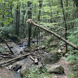
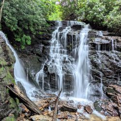
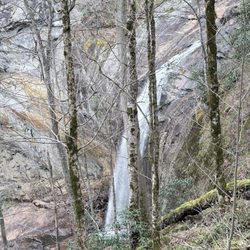
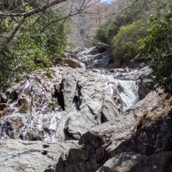
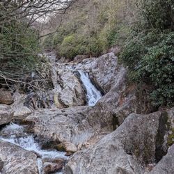
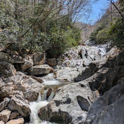
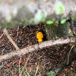
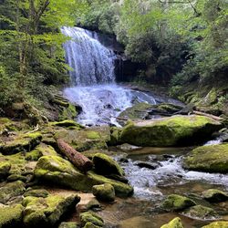
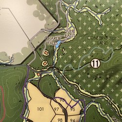
ONION FALLS is not a destination waterfall. Why you ask? Because it is primarily a spillway for the Lake Glenville Dam in North Carolina and its orientation and property restrictions make it difficult to view. In fact, it is waterfalls like this that have given rise to my desire for a drone. Apparently this is not the original Onion Falls. When the river was impounded in the 1940's, the first waterfall was covered over by the dam according to some sources. Still, mapmakers used the same name for the new waterfall location. The name is inspired by the look of the water as it cascades over the round rock surface and gives the appearance of the skin of a white onion. Based on topography maps, the crest of Onion Falls lies just beyond the dam floodgates at around 3,485 feet and falls like a giant waterslide to its base around 3,245 feet, making the total overall height around 240 feet. *** PRO TIP - There is a small parking area near the dam power house, but signs restrict anyone from following the service road down to the base of the falls. The signs warn of police arrest if caught trespassing, so I took heed despite my overwhelming temptation to risk it! THEE BEST VIEW will be just beyond the dam where a small pull-off across from the lake leads to a trail that allows for a distant view of the falls. You will see a metered power box and two metal poles to mark the beginning of the short trail. It also appears possible to bushwhack to the falls by following the river upstream from the High Falls trail, but not sure that is advisable considering the trespass warnings. *** [ THINGS TO KNOW ] Total Hiking Distance: 200 feet Difficulty: Super Easy Creek Crossings: NO Elevation Gain: maybe 10 feet Waterfall Height: around 240 feet overall Waterfall source: West Fork Tuckasegee River WATERFALL ATTRACTIVENESS - 7 out of 10 TRAIL ATTRACTIVENESS - 5 out of 10 Access to top of falls: NO Access to base of falls: NO (heavily restricted) Pool of water @ base of Falls: NO Sitting areas @ base: N/A RESTROOM FACILITIES: NO PARKING: YES (space for about 5 cars) *** [ FINAL THOUGHTS ] While the falls flow is heavily restricted by the dam, the gates have scheduled releases at least 4 times a year making this waterfall a BEAST!!! I highly recommend looking up the "bypass" release dates and planning a trip accordingly for the best and most spectacular look of the falls. On those dates, use Onion Falls as a bonus waterfall as you hike to nearby High Falls downstream. Both High Falls and Onion Falls go from attractive to flat out stunning during the dam release. I HIGHLY RECOMMEND visiting on those dates! Also be sure to check out the The Pines Recreation Area to make it a full day of hiking, waterfall chasing and beach fun and on the opposite side of the lake is Hurricane Falls for a little more waterfall exploration! 2021 / 84 read more


More info about Onion Falls
Pine Creek Rd
Cullowhee, NC 28723
Directions
Hours
Outdoor Amenities


Onion Falls - hiking - Updated June 2026
Best of Cullowhee
People found Onion Falls by searching for…
Beaches in Cullowhee, North Carolina
Things to Do in Cullowhee, North Carolina
Hiking Trails With Waterfalls in Cullowhee, North Carolina
Off Road Trails in Cullowhee, North Carolina
Scenic Overlook in Cullowhee, North Carolina
Scenic Views in Cullowhee, North Carolina
Easy Hikes in Cullowhee, North Carolina
Parking in Cullowhee, North Carolina
Police Departments in Cullowhee, North Carolina
Walking Trails in Cullowhee, North Carolina
Waterfalls in Cullowhee, North Carolina
Waterfalls and Swimming Holes in Cullowhee, North Carolina
Swimming Lakes in Cullowhee, North Carolina
Attractions in Cullowhee, North Carolina
Running Trails in Cullowhee, North Carolina
Scenic Drive in Cullowhee, North Carolina
Landmarks in Cullowhee, North Carolina
Public Services & Government in Cullowhee, North Carolina
Police Station in Cullowhee, North Carolina
Lakes & Ponds in Cullowhee, North Carolina
Chapel in Cullowhee, North Carolina
Night View in Cullowhee, North Carolina
Trending Searches in Cullowhee, NC
Black Owned Nail Salons near Onion Falls
Cliff Jumping near Onion Falls
Dog Friendly Trails near Onion Falls
Fishing Spots near Onion Falls
Jet Ski Rental near Onion Falls
Lakes & Ponds near Onion Falls
Landmarks & Historical Buildings near Onion Falls
Lookout Points near Onion Falls
Off Road Trails near Onion Falls
Public Shower near Onion Falls
River Swimming near Onion Falls
Scenic Overlook near Onion Falls
Scenic Restaurants near Onion Falls
Secluded Spots near Onion Falls
Strawberry Picking near Onion Falls
Swimming Holes near Onion Falls
Browse Articles
Browse Nearby
BEST of Cullowhee, North Carolina Restaurants near Onion Falls
BEST of Cullowhee, North Carolina Things to Do near Onion Falls
BEST of Cullowhee, North Carolina Coffee near Onion Falls
BEST of Cullowhee, North Carolina Shopping near Onion Falls
BEST of Cullowhee, North Carolina Breakfast near Onion Falls
BEST of Cullowhee, North Carolina Beaches near Onion Falls
BEST of Cullowhee, North Carolina Campgrounds near Onion Falls
Browse Brands
Related Searches in Cullowhee, NC
Affordable Jet Ski Rental Options in Cullowhee, North Carolina
Affordable Kayak Rental Services in Cullowhee, North Carolina
Best Fishing Locations and Guides in Cullowhee, North Carolina
Best Fun Things to Do in Cullowhee, North Carolina
Best Lookout Points to Visit in Cullowhee, North Carolina
Best Places for Horseback Riding in Cullowhee, North Carolina
Best Spots for Star Gazing in Cullowhee, North Carolina
Best Things to Do on a Rainy Day in Cullowhee, North Carolina
Check Out Off Road Trails in Cullowhee, North Carolina
Discover Charming Historic Homes in Cullowhee, North Carolina
Discover Dog Friendly Trails to Explore in Cullowhee, North Carolina
Discover Family-Friendly Aquariums in Cullowhee, North Carolina
Discover Famous Monuments in Cullowhee, North Carolina
Discover Historic Sites and Places in Cullowhee, North Carolina
Discover Popular Landmarks in Cullowhee, North Carolina
Discover Stunning Skyline View Spots in Cullowhee, North Carolina
Discover a Hiking Trail in Cullowhee, North Carolina
Discover the Best Beaches in Cullowhee, North Carolina
Discover the Best Caves to Explore in Cullowhee, North Carolina
Discover the Best Night Hike Trails in Cullowhee, North Carolina
Dog-Friendly Hikes With Dogs in Cullowhee, North Carolina
Enjoy Arts & Entertainment in Cullowhee, North Carolina
Enjoy Exciting Mountain Biking Adventures in Cullowhee, North Carolina
Enjoy Hiking Adventures in Cullowhee, North Carolina
Enjoy River Tubing Adventures in Cullowhee, North Carolina
Enjoy Tent Camping Spots Around Cullowhee, North Carolina
Enjoy the Best Tubing Experiences in Cullowhee, North Carolina
Enjoy the Best Walking Trails in Cullowhee, North Carolina
Experience Stunning Sunset Views in Cullowhee, North Carolina
Experience Thrilling White Water Rafting in Cullowhee, North Carolina
Explore Beautiful Botanical Gardens in Cullowhee, North Carolina
Explore Beautiful Castles and Landmarks in Cullowhee, North Carolina
Explore Beautiful Parks and Green Spaces in Cullowhee, North Carolina
Explore Bike Rentals Throughout Cullowhee, North Carolina
Explore Children's Museums Near Cullowhee, North Carolina
Explore Easy Hikes Perfect for All in Cullowhee, North Carolina
Explore Family-Friendly Zoos and Wildlife in Cullowhee, North Carolina
Explore Fun Activities to Do in Cullowhee, North Carolina
Explore Popular Campgrounds Near Cullowhee, North Carolina
Explore Popular RV Parks Around Cullowhee, North Carolina
Explore Popular Scenic Overlook Points in Cullowhee, North Carolina
Explore Popular Scenic Views Near Cullowhee, North Carolina
Explore Scenic Lakes to Visit in Cullowhee, North Carolina
Explore Secret Spots Worth Visiting in Cullowhee, North Carolina
Explore Top Art Galleries Located in Cullowhee, North Carolina
Explore Top Dog Parks in Cullowhee, North Carolina Near You
Explore Venues & Event Spaces in Cullowhee, North Carolina
Explore the Best Boating Spots in Cullowhee, North Carolina
Explore the Best Swimming Holes Around Cullowhee, North Carolina