Will Henry Stevens Covered Bridge Photos


More like Will Henry Stevens Covered Bridge
Recommended Reviews - Will Henry Stevens Covered Bridge
Start your review...

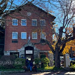
No "shadows of a bear" for me, I passed through Highlands in order to see this famed covered bridge. There really aren't many of them left in the US and very few remain in North Carolina! The bridge is the entrance to the Bascom Center, a six-acre campus of indoor and outdoor artworks. It was named for artist Will Henry Stevens (1881-1949) who lived and painted and taught here in Highlands. The bridge dates back about 200 years when it was originally build in New Hampshire over the Warner River. Disassembled rather than destroyed, it was put into storage in 1966. And then purchased and moved here to Highlands forty years later. Now it's been recreated as an Ithiel Town lattice using traditional techniques and materials including 1100 tree-nails, towels and trunnels with no metal fasteners! Unfortunately, when I arrived it was closed for reconstruction and repair. Blocked off on both sides and surrounded by piles of rough-hewn beams and planks. I'll need to come back when it's all fixed up. [Review 20018 overall - 3458 in North Carolina - 993 of 2023.] read more


10 years ago
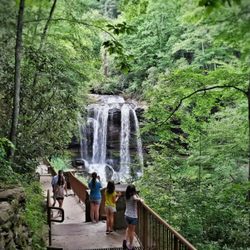
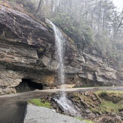
I came to Highlands, NC in search of a bear, or more accurately the "shadow of a bear". A natural phenomenon that happens from mid-October through early November when the setting sun casts a shadow onto the valley below Whiteside Mountain. The shadow takes on the appearance of a bear and I simply could not not miss this one-of-a kind opportunity. The shadow begins at 5:30 p.m. I arrived in town super early (around 1pm) so I decided to do a little exploring. There was a waterfall here I wanted to visit, but I discovered The Bascom Visual Arts Center and decided to make that my first stop. To know me is to know I have a profoundly deep love for old structures, particularly covered bridges. So to discover a covered bridge I was not aware of (that was also historic) in a gorgeous mountain setting was almost orgasmic... and I mean that literally. When I get super excited about something, it makes me wanna go poop! TMI right?, but it's true. There is no greater laxative for me than showing me a picture of someplace gorgeous that I've never been. It's why I keep travel magazines in a woven basket in our bathroom. The excitement for new adventures twists my stomach into knots. So, actually realizing I'm live on location of a place I would have seen in the pages of a magazine brings on a different excitement! LOL --- THE BRIDGE You simply can't get more picturesque than Will Henry Stevens Covered Bridge. A little research revealed this bridge was once considered the oldest covered bridge in New Hampshire. It was named Bagley Covered Bridge and it crossed the Warner River, until it was considered a hazard from its aging condition. The bridge was scheduled to be destroy until Milton & Arnold Graton, lovers of historic bridges, purchased it in 1966 and placed it in storage for the next 42 years. The bridge was built in approximately 1807 out of old growth pine. It is around 14 feet wide and almost 88 feet long. In February of 2008 it was gifted to the Bascom Art Center as a perfect entrance to their facility and reconstruction completed in 2009. This bridge looks like a totally new structure, but in fact is now over 200 years old. The design is Town lattice and uses over 1,100 wooden fasteners in keeping with the original 1800's bridge building traditions. I'm guessing the flares at the bottom were not original to the bridge, but are characteristic of Carolina-style covered bridges. SIDE NOTE: Famous people said to have once crossed this bridge are General Lafayette, President Theodore Roosevelt & President Franklin Pierce. --- FINAL THOUGHTS I am in awe of the dedication to conservation that led this bridge from New Hampshire to the Mountains of North Carolina. What love and genuine concern for the preservation of such an important artifact from a dying era! It truly brings a mist to my eyes to know that someone loved this bridge so much that they saved it, carefully dismantled it, stored it, nurtured it for 4 decades, and rebuilt it once they found it the perfect home. In Georgia, there were once over 600 covered bridges, but only 15 historic ones remain. Most met their end by arson or neglect. So I am very proud to see one of these beauties survived by being blanketed with a great deal of love. I wish we all honored such important structures & relationships in our lives and were less quick to deem things that were once important as antiquated and useless. I read an article about the father and son who saved the bridge, the Grafton's. It highlighted a quote which stated: "To me, to write-off the remaining usefulness of so faithful an old bridge... is like sentencing [someone] without hearing [their] witness. Should not this old bridge have a chance to be heard even through an interpreter?" AMEN 2016/119 read more


More info about Will Henry Stevens Covered Bridge


Will Henry Stevens Covered Bridge - landmarks - Updated July 2026
Best of Highlands
People found Will Henry Stevens Covered Bridge by searching for…
Things to Do in Highlands, North Carolina
Places to Take Pictures in Highlands, North Carolina
Things to Do on a Rainy Day in Highlands, North Carolina
Scenic Overlook in Highlands, North Carolina
Attractions in Highlands, North Carolina
Public Services & Government in Highlands, North Carolina
Photo Spots in Highlands, North Carolina
Scenic Views in Highlands, North Carolina
Waterfalls in Highlands, North Carolina
Fun Things to Do at Night in Highlands, North Carolina
Historical Sites in Highlands, North Carolina
Natural Hot Springs in Highlands, North Carolina
Things to See in Highlands, North Carolina
Waterfalls and Swimming Holes in Highlands, North Carolina
Cultural Center in Highlands, North Carolina
Tourist Attractions in Highlands, North Carolina
Arts & Entertainment in Highlands, North Carolina
Bridge in Highlands, North Carolina
Field Trips in Highlands, North Carolina
Night View in Highlands, North Carolina
View Points in Highlands, North Carolina
State Parks in Highlands, North Carolina
Trending Searches in Highlands, NC
Black Owned Nail Salons near Will Henry Stevens Covered Bridge
Boat Rental near Will Henry Stevens Covered Bridge
Cliff Jumping near Will Henry Stevens Covered Bridge
Day Trips near Will Henry Stevens Covered Bridge
Fireworks near Will Henry Stevens Covered Bridge
Jet Ski Rental near Will Henry Stevens Covered Bridge
Kayak Rental near Will Henry Stevens Covered Bridge
Landmarks & Historical Buildings near Will Henry Stevens Covered Bridge
Lookout Points near Will Henry Stevens Covered Bridge
Picnic Areas near Will Henry Stevens Covered Bridge
Places To Swim near Will Henry Stevens Covered Bridge
River Swimming near Will Henry Stevens Covered Bridge
River Tubing near Will Henry Stevens Covered Bridge
Scenic Restaurants near Will Henry Stevens Covered Bridge
Secluded Spots near Will Henry Stevens Covered Bridge
Strawberry Picking near Will Henry Stevens Covered Bridge
Swimming Holes near Will Henry Stevens Covered Bridge
Swimming Lakes near Will Henry Stevens Covered Bridge
U Pick Farms near Will Henry Stevens Covered Bridge
Browse Articles
Browse Nearby
BEST of Highlands, North Carolina Scenic Drive near Will Henry Stevens Covered Bridge
BEST of Highlands, North Carolina Restaurants near Will Henry Stevens Covered Bridge
BEST of Highlands, North Carolina Photo Spots near Will Henry Stevens Covered Bridge
BEST of Highlands, North Carolina Things to Do near Will Henry Stevens Covered Bridge
BEST of Highlands, North Carolina Coffee near Will Henry Stevens Covered Bridge
BEST of Highlands, North Carolina Breakfast near Will Henry Stevens Covered Bridge
BEST of Highlands, North Carolina Day Trips near Will Henry Stevens Covered Bridge
BEST of Highlands, North Carolina Star Gazing near Will Henry Stevens Covered Bridge
BEST of Highlands, North Carolina Hotels near Will Henry Stevens Covered Bridge
Browse Brands
Related Searches in Highlands, NC
Best Fun Things to Do in Highlands, North Carolina
Best Lookout Points to Visit in Highlands, North Carolina
Best Spots for Star Gazing in Highlands, North Carolina
Best Things to Do on a Rainy Day in Highlands, North Carolina
Best Waterfalls and Swimming Holes in Highlands, North Carolina
Book Engaging Historical Tours in Highlands, North Carolina
Discover Charming Historic Homes in Highlands, North Carolina
Discover Family-Friendly Aquariums in Highlands, North Carolina
Discover Historic Sites and Places in Highlands, North Carolina
Discover Popular Photo Spots in Highlands, North Carolina
Discover the Best Beaches in Highlands, North Carolina
Discover the Best Planetarium Shows in Highlands, North Carolina
Enjoy Arts & Entertainment in Highlands, North Carolina
Enjoy Hiking Adventures in Highlands, North Carolina
Enjoy a Beautiful Waterfall Hike in Highlands, North Carolina
Enjoy the Best Walking Trails in Highlands, North Carolina
Experience Stunning Sunset Views in Highlands, North Carolina
Explore Beautiful Botanical Gardens in Highlands, North Carolina
Explore Beautiful Parks and Green Spaces in Highlands, North Carolina
Explore Family-Friendly Zoos and Wildlife in Highlands, North Carolina
Explore Free Things to Do Around Highlands, North Carolina
Explore Fun Activities to Do in Highlands, North Carolina
Explore Fun Field Trips in Highlands, North Carolina
Explore Popular Scenic Overlook Points in Highlands, North Carolina
Explore Popular Scenic Views Near Highlands, North Carolina
Explore Top Art Galleries Located in Highlands, North Carolina
Explore Venues & Event Spaces in Highlands, North Carolina
Explore the Top Car Museum in Highlands, North Carolina
Find Beautiful Views in Highlands, North Carolina
Find Exciting Tours to Take in Highlands, North Carolina
Find Top-Rated Waterfalls in Highlands, North Carolina Now
Find the Best Bridge Spots in Highlands, North Carolina
Find the Best Playgrounds to Visit in Highlands, North Carolina
Fun Things for Kids in Highlands, North Carolina
Hiking Trails With Waterfalls in Highlands, North Carolina
Must-See Tourist Attractions Around Highlands, North Carolina
Perfect Spots to Watch Sunset in Highlands, North Carolina
Popular Kids Activities in Highlands, North Carolina
Popular Picnic Spots to Visit in Highlands, North Carolina
Popular Places to Take Pictures in Highlands, North Carolina
Popular Things to Do in Highlands, North Carolina
Popular Things to See in Highlands, North Carolina
Public Services & Government Offices in Highlands, North Carolina
Relax at Natural Hot Springs Near Highlands, North Carolina
Top Fun Things to Do at Night in Highlands, North Carolina
Top Hiking Trails to Explore in Highlands, North Carolina
Top Things to Do With Kids in Highlands, North Carolina
Top Things to Do With Teenagers in Highlands, North Carolina