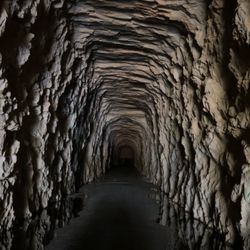
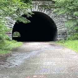
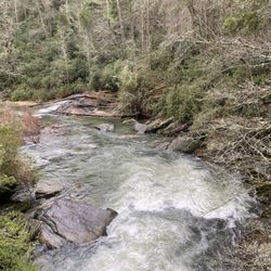
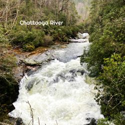
Chattooga River Photos


 - Landmarks & Historical Buildings Near Me - Mountain Rest, South Carolina")
More like Chattooga River
Recommended Reviews - Chattooga River
Start your review...

7 years ago
The Chattooga River is simply one of the most stunning natural places in all the South, and because of its designation as a Wild and Scenic River, it will stay that way for generations to come! Haven't heard of it? It forms the squiggly border on your map between northern Georgia and South Carolina. Its headwaters begin just northwest of Whiteside Mountain @ spring-fed Cashiers Lake, North Carolina. Chattooga was also a location when filming the movie "Deliverance". Whiteside Mountain is a gorgeous protrusion that rises from its surroundings so sharply that two sides of it have white cliffs with sheer drops! Views from this mountain are incredible and a natural phenomenon happens every October around 5:30 pm. As the sun sets, the mountain casts a shadow onto the valley below in the shape of a bear (although I personally think it looks more like a mouse). This is known as The Shadow of the Bear, and people come from all around to see it. By the time Chattooga River reaches the intersection of North Carolina, South Carolina and Georgia, it is a full-scale raging wonder as several tributaries add to its volume along the way! Chattooga River cuts such a deep gorge though the Blue Ridge Mountains that almost every creek that flows into it has one or more gorgeous waterfalls. Some of the waterfalls drop directly into the river such as Dicks Creek Falls and Licklog Falls while others are not far from the shoreline, such as King Falls, Spoonauger Falls and Opossum Falls. { ADVENTURE } Kayakers love this river for its Class IV rapids. It is known as the CROWN JEWEL of Southern white water. The river drops from 3,000 feet to 950 feet over a 50-mile journey, creating some wild and dangerous rapids, particularly near the Hwy 76 Bridge in an area known as Bulls Sluice. The heart-pounding Class IV rapids are strung together over a 1/4 mile gorge, where the river drops more than 75 feet through what has been dubbed the FAMOUS FIVE FALLS... Entrance, Corkscrew, Crack-In-the-Rock, Jawbone, and Sock'em Dog. See Famous Five rapids: https://www.youtube.com/watch?v=0NrjHi_k-AA The Chattooga River ends @ Lake Tugaloo, where the water flows into the Tugaloo River, then into Lake Hartwell and eventually continues south as the Savannah River. It falls under the management of the U.S. Forest Service to keep it protected for future generations as one of the Southeasts only remaining untouched & untamed rivers. There are plenty of places to enjoy the river. Aside from Whitewater Rafting tours, you can also hike the river using the 19 mile Chattooga River Trail or visit locations such as Low Water Campground, Beaver Lane river access road, Burrell's Ford Campground, Earl's Ford Put-In, Bulls Sluice or from the Georgia side follow Sandy Ford Road (near Clayton GA) all the way to the river (truck or SUV advised). Google Maps will show the road ending just before Dicks Creek, but I promise you it actually goes all the way to the river. It even has a beach and nice sized parking area. { FINAL THOUGHTS } The Appalachian Mountains where this gorgeous river is located are the result of continental collision over 350 million years ago when the Eastern United States was once part of Northern Africa. Evidence of this same mountain chain (resulting from said collision) continues in Morocco as the Atlas Mountains after the continents drifted apart. Isn't nature and geology fascinating? No matter where you access the river, it is truly worth your time to visit and see nature in its raw beauty! I HIGHLY RECOMMEND the short hike to Dicks Creek from Clayton, Georgia. This is a gorgeous access point where not only does the river cascade and bend, but you have a beautiful waterfall for even more ambiance and beauty. 2019/46 read more


More info about Chattooga River


Chattooga River - landmarks - Updated June 2026
Best of Mountain Rest
People found Chattooga River by searching for…
Gold Panning in Mountain Rest, South Carolina
Parking in Mountain Rest, South Carolina
Plantation Tours in Mountain Rest, South Carolina
Photo Spots in Mountain Rest, South Carolina
Scenic Drive in Mountain Rest, South Carolina
Historical Tours in Mountain Rest, South Carolina
Hiking Trails in Mountain Rest, South Carolina
View Points in Mountain Rest, South Carolina
Scenic Overlook in Mountain Rest, South Carolina
Things to Do in Mountain Rest, South Carolina
Historical Sites in Mountain Rest, South Carolina
Public Services & Government in Mountain Rest, South Carolina
Scenic Views in Mountain Rest, South Carolina
Beautiful Views in Mountain Rest, South Carolina
Walking Trails in Mountain Rest, South Carolina
Bridge in Mountain Rest, South Carolina
Tourist Attractions in Mountain Rest, South Carolina
Trails in Mountain Rest, South Carolina
Attractions in Mountain Rest, South Carolina
Night View in Mountain Rest, South Carolina
Landmarks in Mountain Rest, South Carolina
River Walk in Mountain Rest, South Carolina