Yellow Branch Falls Photos


More like Yellow Branch Falls
Recommended Reviews - Yellow Branch Falls
Start your review...

Reviews With Photos

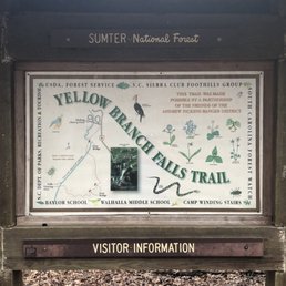
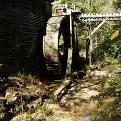
I hiked this trial with several others Yelpers on my first "Off the Grid" hiking Unofficial Yelp Event. This was the longest hike we did. It is about 3 miles roundtrip, which does't sound long unless you have been hiking all day like we had. This trail had a large parking paved parking lot with a bathroom (e.g. hole in ground with a toilet seat over it!). The trail had great views the entire trip. The pathway was wide and there was only one log that you had to cross over. I would consider this hike "moderate." The actual area where the waterfall is located is huge. You have tons of space to walk around and explore or to sit and view the falls. This was my favorite hike of the trip! I just really enjoyed the layout of the hike/falls. The shape of the falls reminded me of a tiered wedding cake! It was just so pretty. The views were pretty amazing. Do not skip out on this hike!

Yellow Branch Falls was the last waterfall we went to on the last Hiking Yelp Event hosted by Richard and Jamarcus which was also my first one. Not only my first Hiking Event but also my first time hiking. This time these guys took us to chase waterfalls to Walhalla, South Carolina. Definitely a great choice with beautiful views (which is why I live for, great views). The itinerary consisted on the following waterfalls: Station Cove Falls King Creek Falls Spoonauger Falls Issaqueena Falls *Yellow Branch Falls Yellow Branch was one of my favorites too. I was told the hike was about 1.5 round trip but it happened to be 3 miles total! I was exhausted but I have to say it was worth it. The trail is super easy, very spacious too so I felt free LOL. Yellow Branch was great and definitely one of my favorites places we visited on the trip. I think it's great for everyone including children. I didn't realize how easy hiking can be. There are indications and marks all over the place to help people follow the right way. My group was super experimented but I feel it would be totally fine for beginners too. No worries. I had so much fun on this event and I discovered what can be my new passion. Shoutout to Richard and his wife Dani for being so helpful and awesome. Every single person at the group was super nice too and willing to wait for me when i was getting too slow. LOL. Thanks y'all. Can't wait for the nexts events coming up. Thanks Richard for the great pictures you took of me!! :D ESPAÑOL Yellow Branch Falls fue la última cascada a la que asistimos en el último Evento de Yelp de Senderismo organizado por Richard y Jamarcus, que también fue el primero. No solo mi primer evento de senderismo, sino también mi primera vez. Esta vez, estos muchachos nos llevaron a cazar cascadas a Walhalla, Carolina del Sur. Definitivamente una gran elección con hermosas vistas (por lo que vivo por, excelentes vistas). El itinerario consistió en las siguientes cataratas: Estación Cove Falls King Creek Falls Spoonauger Falls Issaqueena Falls * Yellow Branch Falls Yellow Branch fue uno de mis favoritos también. Me dijeron que la caminata era de alrededor de 1.5 ida y vuelta, ¡pero resultó ser 3 millas en total! Estaba agotada pero tengo que decir que valió la pena. El sendero es muy fácil, muy espacioso también, así que me sentí libre LOL. Yellow Branch fue genial y, sin duda, uno de mis lugares favoritos que visitamos en el viaje. Creo que es genial para todos, incluidos los niños. No me di cuenta de lo fácil que puede ser el senderismo. Hay indicaciones y marcas por todo el lugar para ayudar a las personas a seguir el camino correcto. Mi grupo fue súper experimentado, pero creo que también estaría bien para los principiantes. Sin preocupaciones. Me divertí mucho en este evento y descubrí cuál puede ser mi nueva pasión. Grita a Richard y su esposa Dani por ser tan serviciales e increíbles. Cada persona del grupo también era súper agradable y estaba dispuesta a esperarme cuando me estaba volviendo demasiado lento. Jajaja Gracias a todos. No puedo esperar a los próximos eventos. read more


7 years ago
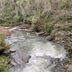
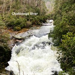
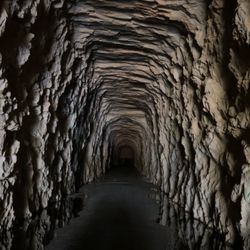
Today I spent the entire day with my wife (of 21 years this month) hiking 5 waterfalls, a 1850's incomplete railroad tunnel, and a historic park. We logged approximately 8 miles and our award for favorite destination of the day goes to Yellow Branch Falls. Here's what we loved: + It is a popular waterfall for both people and pets! Plenty of cute doggies to play with along the trail. + Because it's popular, it didn't feel remote and dangerous, making my non-hiker wife feel more comfortable. + Parking was plentiful + Restroom facility + Wide & spacious trail for the most part and easy to follow + Woods were not dense with foliage and lines of sight were sometimes well over 100 yards. + Creek crossings were easy as the trail made use of bridges, stepping stones and even downed trees. ++ And the biggest reason of all, A STUNNING WATERFALL as a reward for your 1.5 mile efforts. YELLOW BRANCH FALLS is only 50 feet tall, but feels so much larger because its multi-tiered face is about 80 feet wide! It is a magnificent specimen of a waterfall due to the fact that you can not only see ALL of it head on, but it also has an easy to photograph side profile. The reward of a gorgeous waterfall coupled with a pleasant trail that feel like Red Riding Hood's walk to grandma's house makes this our top hike of the day! Our other hikes today included nearby: - Lick Log Falls - Pigpen Falls - Issaqueena Falls - Station Cove Falls (2nd favorite of the day) - Oconee Station Historic Site - Stumphouse Tunnel Be sure to stop by King Taco in Walhalla as a reward for all the calories you will burn on these hikes. Great tacos and burritos! 2019/22 read more


7 years ago
Yellow branch (I kept calling it yellow creek) falls rounded out our day of waterfalls in or near the area of Walhalla, SC, and being the last of the waterfalls for today, it wasn't a bad waterfall! Yellow Branch was the longest of our hikes, being a total of about 3 miles round trip. Being perfectly honest, I'll say that the trail TO the falls was pretty boring and not fun to look at. The trail itself is not the hardest trail, having no real peaks or valleys to conquer. I had a bit of trouble on the way out due to a cramped calf muscle....even still that didn't stop me, so again, this isn't the toughest of trails. Along the trail I should mention there is at least one area where you cross a stream by balancing yourself along a downed tree. This was moss covered as well as surrounded by mud, so foot holds could be an issue here if you aren't sure footed. What about the falls themselves though? In a word, lovely! Not the tallest waterfall that we experienced today, clocking in at 50 feet, this fall was wide, welcoming, and it's all but impossible to get a bad shot here. There are a few smaller cascades along the way to the fall but this is definitely the main attraction. Located pretty close to Issaqueena Falls, I will say if you come to Yellow Branch (or Issaqueena first), you really owe it to yourself to hit both if you have time. Parking at Yellow Branch is very plentiful, however getting parking near the trail head may be a challenge. Basically you'll get a spot, you just may have to walk a bit. Rounding out the park is a decent sized Pagoda near the entrance of the park trail head (to the right), as well as an out house/restroom. Solid waterfall that I was happy to have experienced, and while it's not my favorite waterfall in the Walhalla area, I do think it's a nice one. Check it out if you're in the area! read more


4 years ago
Well kept trail with a beautiful waterfall ending. Be warned, definitely an easier hike getting to the falls than it is on the way out, with a steady incline leading to the parking lot. A little over 1.5 miles each way, moderately trafficked. read more

7 years ago
I hiked this trial with several others Yelpers on my first "Off the Grid" hiking Unofficial Yelp Event. This was the longest hike we did. It is about 3 miles roundtrip, which does't sound long unless you have been hiking all day like we had. This trail had a large parking paved parking lot with a bathroom (e.g. hole in ground with a toilet seat over it!). The trail had great views the entire trip. The pathway was wide and there was only one log that you had to cross over. I would consider this hike "moderate." The actual area where the waterfall is located is huge. You have tons of space to walk around and explore or to sit and view the falls. This was my favorite hike of the trip! I just really enjoyed the layout of the hike/falls. The shape of the falls reminded me of a tiered wedding cake! It was just so pretty. The views were pretty amazing. Do not skip out on this hike! read more


10 years ago
Want a beautiful walk in the woods with a huge reward? Then you've got to take this hike. Yellow Branch Falls is a 50' cascading waterfall that is beyond beautiful. Hiking approximately 1.5 miles one-way through serene forest, this trail has some narrow uneven terrain and is considered to be 'moderate' in difficulty. There are three primitive creek crossings with stepping stones that keep hikers relatively dry and three foot bridges. The reward for your effort is an amazingly beautiful falls, but the walk in the woods to get there is reward enough. Just do it! read more


More info about Yellow Branch Falls
Ask the Community - Yellow Branch Falls


Why does Yelp recommend reviews?
1 review that is not currently recommended
The reviews below are not factored into the business's overall star rating.
8 years ago
Yellow Branch Falls - landmarks - Updated June 2026
Best of Walhalla
People found Yellow Branch Falls by searching for…
Hiking Trails With Waterfalls in Walhalla, South Carolina
Scenic Overlook in Walhalla, South Carolina
Parks in Walhalla, South Carolina
Things to Do in Walhalla, South Carolina
Places to Take Pictures in Walhalla, South Carolina
Waterfalls in Walhalla, South Carolina
Beautiful Views in Walhalla, South Carolina
Secret Spots in Walhalla, South Carolina
Walking Trails in Walhalla, South Carolina
View Points in Walhalla, South Carolina
Attractions in Walhalla, South Carolina
Historical Sites in Walhalla, South Carolina
Photo Spots in Walhalla, South Carolina
Scenic Drive in Walhalla, South Carolina
Scenic Views in Walhalla, South Carolina
Lookout Points in Walhalla, South Carolina
Hiking in Walhalla, South Carolina
Waterfalls and Swimming Holes in Walhalla, South Carolina
Romantic Views in Walhalla, South Carolina
Landmarks in Walhalla, South Carolina
Places to Visit in Walhalla, South Carolina
Views in Walhalla, South Carolina
Trending Searches in Walhalla, SC
Black Owned Nail Salons near Yellow Branch Falls
Boat Rental near Yellow Branch Falls
Cliff Jumping near Yellow Branch Falls
Day Trips near Yellow Branch Falls
Hidden Gems near Yellow Branch Falls
Historical Sites near Yellow Branch Falls
Jet Ski Rental near Yellow Branch Falls
Kayak Rental near Yellow Branch Falls
Landmarks & Historical Buildings near Yellow Branch Falls
Lookout Points near Yellow Branch Falls
Pool Supplies near Yellow Branch Falls
River Swimming near Yellow Branch Falls
River Tubing near Yellow Branch Falls
Secluded Spots near Yellow Branch Falls
Soccer Store near Yellow Branch Falls
Strawberry Picking near Yellow Branch Falls
Swimming Holes near Yellow Branch Falls
Swimming Lakes near Yellow Branch Falls
U Pick Farms near Yellow Branch Falls
Browse Articles
Browse Nearby
Browse Brands
Related Searches in Walhalla, SC
Best Fishing Locations and Guides in Walhalla, South Carolina
Best Lookout Points to Visit in Walhalla, South Carolina
Best Observation Deck Views in Walhalla, South Carolina
Best Places for Stunning Views in Walhalla, South Carolina
Best Things to Do on a Rainy Day in Walhalla, South Carolina
Discover Charming Historic Homes in Walhalla, South Carolina
Discover Family-Friendly Aquariums in Walhalla, South Carolina
Discover Famous Monuments in Walhalla, South Carolina
Discover Fun Kid Activities to Enjoy in Walhalla, South Carolina
Discover Historic Sites and Places in Walhalla, South Carolina
Discover Popular Landmarks in Walhalla, South Carolina
Discover Popular Photo Spots in Walhalla, South Carolina
Discover Romantic Views in Walhalla, South Carolina
Discover the Best Beaches in Walhalla, South Carolina
Discover the Best Military Museum in Walhalla, South Carolina
Enjoy Arts & Entertainment in Walhalla, South Carolina
Enjoy Hiking Adventures in Walhalla, South Carolina
Enjoy the Best Walking Trails in Walhalla, South Carolina
Explore Beautiful Botanical Gardens in Walhalla, South Carolina
Explore Beautiful Castles and Landmarks in Walhalla, South Carolina
Explore Beautiful Parks and Green Spaces in Walhalla, South Carolina
Explore Children's Museums Near Walhalla, South Carolina
Explore Family-Friendly Zoos and Wildlife in Walhalla, South Carolina
Explore Free Things to Do Around Walhalla, South Carolina
Explore Fun Activities to Do in Walhalla, South Carolina
Explore Popular Scenic Overlook Points in Walhalla, South Carolina
Explore Popular Scenic Views Near Walhalla, South Carolina
Explore Popular View Points Around Walhalla, South Carolina
Explore Scenic Lakes to Visit in Walhalla, South Carolina
Explore Top Art Galleries Located in Walhalla, South Carolina
Explore Venues & Event Spaces in Walhalla, South Carolina
Find Exciting Tours to Take in Walhalla, South Carolina
Find the Best Playgrounds to Visit in Walhalla, South Carolina
Hiking Trails With Waterfalls in Walhalla, South Carolina
Must-See Tourist Attractions Around Walhalla, South Carolina
Perfect Spots to Watch Sunset in Walhalla, South Carolina
Popular Kids Activities in Walhalla, South Carolina
Popular Places to Take Pictures in Walhalla, South Carolina
Popular Things to Do in Walhalla, South Carolina
Popular Things to See in Walhalla, South Carolina
Relax at Natural Hot Springs Near Walhalla, South Carolina
Secure Convenient Parking Options in Walhalla, South Carolina
See Top Fireworks Events in Walhalla, South Carolina
Top Entertainment Options in Walhalla, South Carolina
Top Things to Do With Kids in Walhalla, South Carolina
Top Things to Do With Teenagers in Walhalla, South Carolina
Tour Famous Lighthouses Located in Walhalla, South Carolina
Visit Cultural Centers in Walhalla, South Carolina
People who viewed Yellow Branch Falls also viewed
King Creek Falls
7 reviews
Dry Falls
83 reviews
Blue Valley Overlook
3 reviews
Sky Valley Overlook
7 reviews
Bridal Veil Falls
25 reviews
Old Iron Bridge
1 review
Town of Highlands
2 reviews
Opossum Creek Falls Trailhead
1 review
Andre Michaux Historical Marker
1 review
Lynching of Allen Green Historical Marker
1 review