King Creek Falls Photos


More like King Creek Falls
Recommended Reviews - King Creek Falls
Start your review...

Reviews With Photos

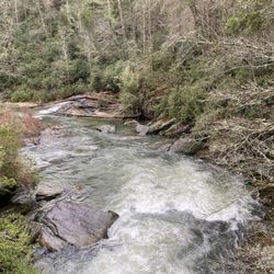
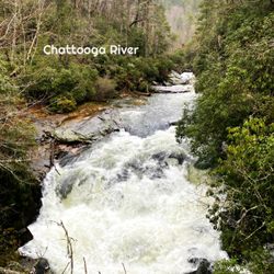
Probably one of my favorite water falls in Walhalla so far, King Creek Falls is powerful. So much so that when you reach it, you can feel the wind blowing off of the water falling. King Creek starts at a well paved parking lot and stretches about 1.2 miles round trip. As you walk you'll see people switching back from time to time....don't worry, this is the same trail and there are no deviating branch offs that will cause you to get lost, except at the parking lot. The trail for king Creek starts near the entrance to the parking lot and is NOT the trail that you see at the bottom of the parking lot. Don't go here if you're looking for this fall. The portion of the group I walked with commented a lot on the trail narrowing at places, as well as being choked with wet, slippery tree roots at places. It IS full of tree roots and narrow, so please watch your step in areas as falling is a possibility. This is not a challenging trail though, so once you get your bearings, you'll be just fine at most age ranges and fitness levels. The waterfall itself can be seen as you come up the trail, but when you turn the final corner, whoa....it's stunning. The falls kinda funnel in on itself and again, the power of the waterfall makes its own wind that can be felt in that entire area. Beautiful photos here are effortless, although having lunch here is tough with everything being wet and slippery. Yep you can walk right up to the waterfall but again, be careful due to the slippery rock surfaces. Located near mountain rest, SC, getting to King Creek From Atlanta (where we came from) is about a 2 hour drive. The road to king creek is part gravel, part natural soil, but not the worst gravel trail i've Been on. Be sure if you pay King Creek a visit that you go to the nearby spoonauger falls, which is maybe a half mile down from the parking lot where the King Creek trail starts. As always, there is an out house here for restroom breaks, but no running water, etc. Again, one of my favorite waterfalls of the day here in South Carolina. I'm a big fan of this waterfall and very likely will be back sooner than later!

Shoutout to Richard and Jamarcus for organizing the Yelp UYE waterfalls trips again. I learned about so many waterfalls I've never would've known or even gotten together to go explore. I've always loved waterfalls and used to force my family to go to all the local parks with them and up north before Yelp was a thing. Walhalla SC has great waterfalls! Plus they are all close by. It reminds me of Helen where there is just more to be discovered! What makes it great for Atlantans is, it's really close to GA and not far from the border. King Creek Falls has a parking lot but it could be confusing to where the trailhead is. We walked straight and asked locals but they guided us to the right area. Thank goodness! There's also an outhouse? Is that what it's called? It was disgusting to me. Things like this makes me wish I was a male haha but thank goodness I do not have to go that badly. Once we went on the trail, there was no turning back. The trail is much more narrow with lots of tree roots. We crossed a creek too with no bridge. Because of this trail, I decided to go purchase a hiking water shoe. Plus I saw Maria walk on water and I want to do that. I shall come back to Walhalla again to explore the waterfalls that I wasn't able to with the group. 46/2019

2 months ago
Beautiful falls! You can find the trail head near the entrance of the campground parking lot. Then follow the white paint marks to the falls! read more
 - Landmarks & Historical Buildings Near Me - Tamassee, South Carolina")


Second on the list was Kings Creek Fall on the last Hiking Yelp Event hosted by Richard and Jamarcus which was also my first one. Not only my first Hiking Event but also my first time hiking. This time this guys took us to chase waterfalls to Walhalla, South Carolina. Definitely a great choice with beautiful views (which is why I live for, great views). The itinerary consisted on the following waterfalls: Station Cove Falls * King Creek Falls Spoonauger Falls Issaqueena Falls Yellow Branch Falls This trail was a little more tricky than the one before. First of all. The GPS would make you turn left right before the actual parking lot of this trail and it'll take you somewhere else. Right ahead you'll see the parking lot which it is where it actually starts. Everything was well signaled and mark for everyone to follow the directions but trail was full of roots making it a little harder. Even though I was already exhausted when I got to the waterfall once I saw it, it refreshed me and gave me energy to keep going. This waterfall is about 70 ft and it is absolutely majestic. I brought my chacos to this event so I was able to get inside the river and closer to the waterfall and I believe here is where I got better pictures. I think I was pretty brave to do that too. LOL. I had so much fun on this event and I discovered what can be my new passion. Shoutout to Richard and his wife Dani for being so helpful and awesome. Every single person at the group was super nice too and willing to wait for me when i was getting too slow. LOL. Thanks y'all. Can't wait for the nexts events coming up. ESPAÑOL El segundo lugar de la lista fue Kings Creek Fall en el último Evento de Yelp de Senderismo organizado por Richard y Jamarcus, que también fue el primero. No solo mi primer evento de senderismo, sino también mi primera vez. Esta vez, estos muchachos nos llevaron a cazar cascadas a Walhalla, Carolina del Sur. Definitivamente una gran elección con hermosas vistas (por lo que vivo por, excelentes vistas). El itinerario consistió en las siguientes cataratas: Estación Cove Falls * King Creek Falls Spoonauger Falls Issaqueena Falls Rama amarilla Falls Este camino fue un poco más complicado que el anterior. Ante todo. El GPS te haría girar a la izquierda antes del estacionamiento real de esta ruta y te llevará a otro lugar. Justo delante verá el estacionamiento, que es donde realmente comienza. Todo estaba bien señalado y marcó para que todos siguieran las instrucciones, pero el camino estaba lleno de raíces, lo que lo hacía un poco más difícil. Aunque ya estaba agotado cuando llegué a la cascada una vez que lo vi, me refrescó y me dio energía para seguir adelante. Esta cascada es de unos 70 pies y es absolutamente majestuosa. Traje mis chacos a este evento, así que pude entrar al río y acercarme a la cascada, y creo que aquí es donde obtuve mejores fotos. Creo que también fui muy valiente para hacer eso. Jajaja Me divertí mucho en este evento y descubrí cuál puede ser mi nueva pasión. Grita a Richard y su esposa Dani por ser tan serviciales e increíbles. Cada persona del grupo también era súper agradable y estaba dispuesta a esperarme cuando me estaba volviendo demasiado lento. Jajaja Gracias a todos. No puedo esperar a los próximos eventos. read more


7 years ago
Today we kicked off our 2019 Off-The-Grid Hiker's Club season!!! As some of you may know, Jamarcus, Bill and I have been hiking buddies for several years now since first meeting on yelp. We formed our own little hiking group about 5 years ago and have hosted several hikes each year, with 2017 being our busiest year logging over 15 hikes! We took a break from posting events in 2018, but we still continued to hike together. But we are back again offering our Atlanta yelp family a chance to shed dress codes, stress and urban life in exchange for the beauty of nature!!! As always, we try to pack our hiking excursions with plenty to yelp about and this was no exception. King Creek Falls was our second stop of FIVE waterfalls we visited today! While each was amazing in its own right, King Creek was one of the most impressive of the day! Clocking in at 70 feet tall, it certainly felt much larger as the volume of water was so great it created its own wind! Our group consisted of several rookie hikers and one yelper to whom this hike would be her very first experience ever! The distance to this waterfall was one of the longer hikes of the day at about 1.2 miles round trip with little elevation change, making it an excellent waterfall for newbie hikers and families. But be forewarned, the trail is rather narrow and full of tree roots. * * * PRO TIP - The trail to King Creek Falls begins near the entrance to the parking areal! DO NOT follow the trail towards the back of the parking area as that leads down to Chatooga Creek and not the falls. * * * [ FINAL THOUGHTS ] What a great day! Upper 60's made it comfortable, rain for the past week made for a spectacular and powerful waterfall display and good company allowed it to be not only fulfilling, but bonding! Today felt more like a family outing than just a few strangers getting together. Thank you to our entire hiking crew for coming out and making today such a special day. I hope you had fun, I certainly did and can't wait to read your reviews of all the places we visited! I've shared all the pics I have for each of you to enjoy! SHOUT OUTS TO: * Nicki K. and her husband * Erica G. (our local Yelp Ambassador extraordinaire) and her +1 * Jessica L. and her fabulous +1 Harrison (whom we have instantly adopted into the yelp family although he doesn't yet have an account) * Sheena S. and her +1 * María O. (1st time hiking ever) * Kiran T. (Atlanta's local Party Animal) * My beautiful wife Dani and our dog Finn and of course my Hiking Club founding partners in crime Jamarcus T., William 'Wild Bill' G. and their lovely plus ones Ester and Paige! (16 total) 2019/33 read more
, Jamarcus, Maria, Nicki & Sheena. - Landmarks & Historical Buildings Near Me - Tamassee, South Carolina")


3 years ago
7 years ago
Probably one of my favorite water falls in Walhalla so far, King Creek Falls is powerful. So much so that when you reach it, you can feel the wind blowing off of the water falling. King Creek starts at a well paved parking lot and stretches about 1.2 miles round trip. As you walk you'll see people switching back from time to time....don't worry, this is the same trail and there are no deviating branch offs that will cause you to get lost, except at the parking lot. The trail for king Creek starts near the entrance to the parking lot and is NOT the trail that you see at the bottom of the parking lot. Don't go here if you're looking for this fall. The portion of the group I walked with commented a lot on the trail narrowing at places, as well as being choked with wet, slippery tree roots at places. It IS full of tree roots and narrow, so please watch your step in areas as falling is a possibility. This is not a challenging trail though, so once you get your bearings, you'll be just fine at most age ranges and fitness levels. The waterfall itself can be seen as you come up the trail, but when you turn the final corner, whoa....it's stunning. The falls kinda funnel in on itself and again, the power of the waterfall makes its own wind that can be felt in that entire area. Beautiful photos here are effortless, although having lunch here is tough with everything being wet and slippery. Yep you can walk right up to the waterfall but again, be careful due to the slippery rock surfaces. Located near mountain rest, SC, getting to King Creek From Atlanta (where we came from) is about a 2 hour drive. The road to king creek is part gravel, part natural soil, but not the worst gravel trail i've Been on. Be sure if you pay King Creek a visit that you go to the nearby spoonauger falls, which is maybe a half mile down from the parking lot where the King Creek trail starts. As always, there is an out house here for restroom breaks, but no running water, etc. Again, one of my favorite waterfalls of the day here in South Carolina. I'm a big fan of this waterfall and very likely will be back sooner than later! read more


Shoutout to Richard and Jamarcus for organizing the Yelp UYE waterfalls trips again. I learned about so many waterfalls I've never would've known or even gotten together to go explore. I've always loved waterfalls and used to force my family to go to all the local parks with them and up north before Yelp was a thing. Walhalla SC has great waterfalls! Plus they are all close by. It reminds me of Helen where there is just more to be discovered! What makes it great for Atlantans is, it's really close to GA and not far from the border. King Creek Falls has a parking lot but it could be confusing to where the trailhead is. We walked straight and asked locals but they guided us to the right area. Thank goodness! There's also an outhouse? Is that what it's called? It was disgusting to me. Things like this makes me wish I was a male haha but thank goodness I do not have to go that badly. Once we went on the trail, there was no turning back. The trail is much more narrow with lots of tree roots. We crossed a creek too with no bridge. Because of this trail, I decided to go purchase a hiking water shoe. Plus I saw Maria walk on water and I want to do that. I shall come back to Walhalla again to explore the waterfalls that I wasn't able to with the group. 46/2019 read more


7 years ago
I hiked this trail with several others Yelpers on my first "Off the Grid" hiking Unofficial Yelp Event. This was our second hike of the day. This trail had a paved parking lot that was much bigger. There was a bathroom (e.g. a hole in the ground with a toilet seat over it!) that you could access before your hike. The location of the trailhead was a little confusing. At first, our group started walking away from the road to the back of the parking lot near a gate. But as we approached it, several hikers told us that the trailhead to see the waterfalls was closer the front of the parking lot. It was hidden and pushed back, which was the reason we didn't see it first. This trail was VERY narrow and full of roots, so be aware that you will be walking with your head down a lot to not trip. Overall, the hike is fairly easy though. This waterfall is a great size and beautiful! There is not as much standing room as some of the other waterfalls I've been to, so group pictures might be more of a challenge. read more


More info about King Creek Falls
Ask the Community - King Creek Falls


King Creek Falls - landmarks - Updated May 2026
Best of Tamassee
People found King Creek Falls by searching for…
Scenic Overlook in Tamassee, South Carolina
Places to Take Pictures in Tamassee, South Carolina
Parking in Tamassee, South Carolina
View Points in Tamassee, South Carolina
Waterfalls in Tamassee, South Carolina
Off Road Trails in Tamassee, South Carolina
Day Trips in Tamassee, South Carolina
Secret Spots in Tamassee, South Carolina
Hiking Trails in Tamassee, South Carolina
Historical Tours in Tamassee, South Carolina
Scenic Drive in Tamassee, South Carolina
Walking Trails in Tamassee, South Carolina
Scenic Views in Tamassee, South Carolina
Plantation Tours in Tamassee, South Carolina
Urban Exploration in Tamassee, South Carolina
Beautiful Views in Tamassee, South Carolina
Historical Sites in Tamassee, South Carolina
Things to See in Tamassee, South Carolina
Romantic Views in Tamassee, South Carolina
Public Services & Government in Tamassee, South Carolina
Jogging Trails in Tamassee, South Carolina
Bridge in Tamassee, South Carolina