Lick Log & Pigpen Falls Photos


More like Lick Log & Pigpen Falls
Recommended Reviews - Lick Log & Pigpen Falls
Start your review...

7 years ago
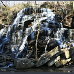
Lick Log & Pigpen Falls are two waterfalls found along a mile long section of the Chattooga River Trail, which can be access via the Foothills Trail from the Nicholson Ford Road parking area. The 2.2 mile gravel road can be extremely narrow in several areas, making it impossible for two cars going in opposite directions to pass each other. If you are squeamish about narrow mountain passes, you may want to think twice about driving here. The trailhead from the parking lot uses white blaze markers. You will cross two wooden footbridges and about a half mile in you will come to the intersection of Foothills Trail and Chattooga Trail. Turn left at the intersection onto Chattooga Trail. Within 30 feet you will see a slender ground sign with an arrow pointing towards Lick Log Falls and just beyond the sign, Pigpen falls will come into view on your left. [ THE FALLS ] PIGPEN FALLS is approximately 25 feet tall, but not all of it is visible due to heavy vegetation masking the upper portion of the waterfall. The waterfall itself is really interesting because there is a main area, but also the side-slanting nature of the stones carries a stream of water off to the right for a little more dramatic effect. There is a small shallow pool of water at its base that would be a better vantage point for photo's if you don't mind getting your feet wet. Continue along Chattooga Trail across the footbridge until you reach LICK LOG FALLS. It was here I instantly wished that I owned a drone, because THIS waterfall is difficult to see in its entirety. A drone would have given me a superior vantage point. The total height of the waterfall is said to be about 80 feet, but that is spread out over two dramatic upper tiers (visible from the trail), a series of cascades (completely masked by vegetation) and a large lower tier that spills directly into the Chattooga River. To access the lower tier, you must traverse down a STEEP side trail leading to the sandy shores of the Chattooga River. Turn right and the grand lower falls is right there! [ THE NAME LICK LOG ] Lick Log is a strange name, one that made me wonder what the heck someone was thinking when naming the creek from which this waterfall gets its name. So, I did a little research and found that licklog is an old term used by early ranchers. They would carve out a trough from a tree trunk and fill it with salt for cows to lick. In turn this would make the cows thirsty and the rancher would then lead them to a river for a drink. Typically, this would happen just before the rancher would take them to be slaughtered. It was used as a trick to increase their weight, possibly so the rancher could earn more money per pound. Because it was the last thing the cow would do before being slaughtered, the term lick log became synonymous with meaning "down to the last possible second." Lawyers began to coin the term licklog as a way of saying they have exhausted all efforts to resolve a matter. THUS Lick Log is a very appropriate name for this waterfall because the creek literally flows down the waterfall to the last possible second before spilling into the Chattooga River. [ FINAL THOUGHTS ] Although I deducted a star for both falls being difficult to see, this will not be the last of my reviews along this trail. The Chattooga River is absolutely one of the most scenic rivers I've ever visited and acts as a border between South Carolina and Georgia. The Chattooga Trail totals 15 miles one way and feature three other waterfalls: Spoonauger (50'), Big Bend (30') and King Creek (70'). My goal this summer will be to organize a group hike with my hiking buddies Jamarcus and Bill, where we park cars at both ends of the trail for a coordinated one-way day hike! If you've ever wanted to hike with our crew, this will be one of the biggest hikes of the year! However, whether you want to hike the entire Chattooga Trail or just the 1 mile section from Nicholas Ford Road to the base of Lick Log Falls, you are in for a multiple waterfall treat! Enjoy! 2019/12 read more


7 years ago
What a nice surprise on what basically is a nature walk! Lick Log & Pigpen Falls can be found if you walk towards the Chattooga RIver trail from the gravel lot. Be sure to take the foothills trail, because the Chattooga river trail continues on in the opposite direction of these two falls and if you're not careful, you'll never see these! Before I get to the pleasant hike, you should be aware of the drive. Yep, there is a gravel road that initially is wide, but quickly turns into a one lane road. On our drive, we came across two water crossings that I wasn't sure that my Honda accord could cross without stalling out, but cross it we did! Still, after or during heavy rains, you may need a 4WD vehicle to get past the water. You'll eventually make it to a fork in a road. To the left is a private drive and to the right ultimately leads to the small parking lot. The Chattooga river trail along the foothills trail is approximately 0.7 miles and not even halfway into the walk you'll come across Pigpen falls. Pigpen is off the trail, and you hear it before you see it. It's really covered with heavy vegetative growth, and I imagine it's a bit easier to see from the trail during the winter months when all the vegetation has cleared a bit. It's not a really large waterfall, but it's a cool one to see nonetheless. Along the trail, you'll pass several small cascades, a campfire spot, and ultimately you'll come up on a series of signs in a clearing. Pointing to the left is a sign with an arrow towards Lick LG Falls. You can continue straight to the Chattooga foot hills North trail (although you wont catch Lick log this way). We had the entirety of Lick Lock falls to ourselves, and man I smiled ear to ear when I saw it. The fall ends here, draining out into a pond, and I thought the waterfall to the left was basically all of Lick Log, but i noticed that far and away up, I could see water coming down through the brush. Man if this was cleared, it would be an impressive fall...more impressive than it already was! One of the longer wooden bridges (you'll cross three) along the trail is here, and it just adds to the charm of this lush wonderland. Difficulty of this hike is barely there. I personally wouldn't call it a hike so much as I would call it a nature walk. Very small incline that you walk down into and slightly climb out of on your way out. So are both Lick Log falls and Pigpen falls worth a drive out? If you live close, it's a no brainer. Even if you're like me and you're coming from Atlanta, it's definitely worth it if you bundle it with other waterfalls like we did. When (not if) I return, i'll continue further along the trail for more exploration, but for now, i'm quite pleased with what I found here! Check it out!! read more


More info about Lick Log & Pigpen Falls


Lick Log & Pigpen Falls - landmarks - Updated May 2026
Best of Mountain Rest
People found Lick Log & Pigpen Falls by searching for…
Parks in Mountain Rest, South Carolina
Scenic Drive in Mountain Rest, South Carolina
Things to Do in Mountain Rest, South Carolina
Waterfalls in Mountain Rest, South Carolina
Photo Spots in Mountain Rest, South Carolina
Scenic Views in Mountain Rest, South Carolina
Waterfalls and Swimming Holes in Mountain Rest, South Carolina
Places to Take Pictures in Mountain Rest, South Carolina
Hiking Trails in Mountain Rest, South Carolina
Scenic Overlook in Mountain Rest, South Carolina
Walking Trails in Mountain Rest, South Carolina
View Points in Mountain Rest, South Carolina
Field Trips in Mountain Rest, South Carolina
Off Road Trails in Mountain Rest, South Carolina
Historical Sites in Mountain Rest, South Carolina
Natural Hot Springs in Mountain Rest, South Carolina
Views in Mountain Rest, South Carolina
What to Do in Mountain Rest, South Carolina
Scenic Places to Walk in Mountain Rest, South Carolina
Night View in Mountain Rest, South Carolina
Beautiful Views in Mountain Rest, South Carolina
Bridge in Mountain Rest, South Carolina