Glen Falls Trail Photos


More like Glen Falls Trail
Recommended Reviews - Glen Falls Trail
Start your review...

Reviews With Photos
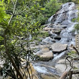


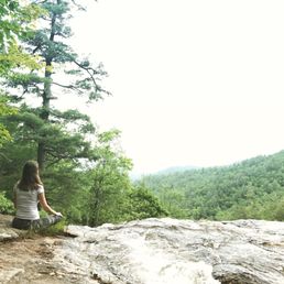
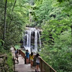
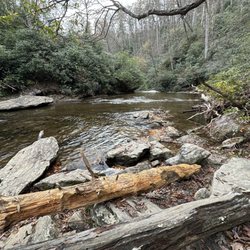
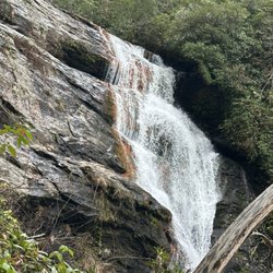
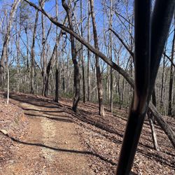
FIRST, I want to thank my friend Jamarcus T. for selecting this waterfall trail as our monthly hiker's club destination for June of 2017. I'd come here once before on the way home from Asheville in 2011, but threatening weather discouraged us from hiking and we never returned. SECOND, I want to say Glen Falls now ranks in my top three favorite waterfall hikes in the South! THE EXPERIENCE After you find the parking area, the hike itself is roughly 1 mile to the last fall, all of which is downhill (2 miles round trip). The trail breaks off several times to other trails leading to other lesser falls along East Fork Overflow Creek. One trail in particular places you at the crest of the first large fall where you can get a window seat view of the valley below. The valley view is beautiful, but I was not prepared for the size and beauty of the first large waterfall we came to along the main trail. It was impressive to say the least and made for some excellent family photo opportunities. There is an observation deck, but our group climbed over and around the barriers to walk directly out to the base of the fall. One of our teenagers discovered quickly that waterfalls are slippery and you need to be very careful as he went careening down a slippery slope, but thankfully he landed on a small island of plants that stopped him from sliding further (which would have been deadly had he continued sliding). The next waterfall (known as the middle fall) was my favorite and it was different than the first in that it was very accessible. The first was a plunging drop around 70 feet while the second was more of a cascading waterfall over several shale ledges @ around 60 feet tall. The ledges also made it easy to climb and explore. Our group spent the most time at this waterfall and several didn't want to leave. The last fall at the trails end was around 15 feet and plunges into a small shallow pool of water. Directly in front of the fall is a huge fallen tree trunk you could use as a ramp to the base. All by itself it is a nice waterfall, but kinda looses its awesomeness in comparison to the other two falls. If you are short on time or energy, this one could be skipped. While the hike to the last fall was easy, what goes down (in this case) must come back up and that easy hike 'in' becomes far more difficult 'out'. It is said the elevation drop is around 700 feet from the parking area to the final fall. That's a fairly decent leg workout, but I would do this hike again and again and again. It is by far one of the most rewarding hikes around. FINAL THOUGHT I love hiking and I love waterfalls, but I particularly love it when one trail rewards you with multiple waterfalls and scenic overlook venues. Hikes like this are highly valuable to me, not only for their peaceful serenity, but also as wonderful destinations to impress out-of-town guests. The drive from Atlanta to these waterfalls is barely 2 hours, which makes for an amazing day trip or even a weekend getaway. Aside from this gorgeous trail, there are also several roadside overlooks and nearby waterfalls that require almost no hiking. You could easily add any of them to your daytrip itinerary. Three excellent additions you should consider when visiting Glen Falls are Mud Falls, Dry Falls and Sky Valley or Blue Valley Overlooks. ENJOY!!! ----- OTHER GREAT MULTI-WATERFALL TRAILS include: * High Falls Trail | Dupont State Forest, NC * Rainbow Falls Trail | Gorges State Park, SC * Angel Falls Trail | near Helen, GA 2017/103

What an amazing find! Out waterfall hunting on a beautiful Saturday, Glen Falls was on my agenda for the day. Although i'm all over the georgia hiking scene, i'm just getting into North Carolina, and i'm loving what i'm seeing! Coming from highway 106, follow it north (if you're leaving the state of GA) until you see holt road. There's a often missed sign that points to Glen Falls, which leads you down Glen Falls road, which is about a 1 mile gravel trail. No worries here though, because this gravel trail is very well driven, and my honda accord took it in stride. Parking can fit about 10 or so vehicles and parking also marks two trail heads. One of those trail heads is the Glen Falls trail, which is a 1 mile in and out trail (i.e. 2 miles round trip). The other trail is the Chinquapin trail, which I didn't do today. Glen Falls will lead you down to a total of 5 viewing areas, and three absolutely beautiful cascades that each drop about 60 feet on what is the eastern fork in the blue valley area. Stops one and two are okay falls, and I really thought to myself "did I drive all the way to North Carolina for this???" Relax though, because once you hit overlook three, which gives you these wonderful twin falls, things just get better and better from there! Overlook four gives you a really nice, full waterfall that looks like a large sheet of water covering the rock face, and the fifth overlook leads to a nice little pond of water where the water empties out into. It's your own private area that's actually much more calm as far as power and intensity go. The trails themselves aren't really marked at all, outside of the trail head, but overlooks 1 through 4 all are very common sense, easy to follow trails, based on stairs and man made features. Those trails are also natural dirt trail (minus the initial gravel portion before you hit overlook 1). Going from overlook four to five was kinda annoying to me, because the trail was choked with big roots, and I was constantly watching my foot placement for fear of twisting an ankle. You do sometimes get the sense that you're losing the trail here, but when you think that, just keep an ear out for the falls. Does it sound like you're getting closer? You're not lost. If it's getting further away...yea, you're lost. The good thing is Glen Falls is a well hiked trail, and I saw several kids, parents, older adults on the trail. Before you take Glen falls on though, just keep in mind it's an all down hill trail, which is excellent going in, but coming out will make you work. Just make sure you can handle the huffing and puffing. Another excellent North Carolina Fall that doesn't disappoint the falls lover in you, and can be easily found if you're looking in the right place. As always, no cell phone service (I had AT&T), there are restrooms, and you may want to bring some extra socks because some of the trails get wet. Get out there and enjoy!

Highlands, NC has great waterfalls. I'm learning about them. Plus it's not too far from GA so the trip is worth it. If you travel Highway 106, you will take a sharp turn into Glen Falls Road, which is a gravel road. There is limited parking. However, you could park along side of the road. I was surprised to see two trails but hey, I'm here for Glenn Falls cause I'm obsess with waterfalls. It's 2 miles, round trip. It is easy going to the waterfalls but coming back will be a challenge since you are going downhill. There are 5 waterfalls in all. The first two were okay. I wanted more. Once we got to the third waterfall, it was amazing! You could get up close and personal! Once you get closer to the last waterfall, which is going towards a lagoon, the trail is harder cause of tree roots. Look, I have to be careful since I sprained my ankle the last time I went hiking and am still recovering. I tripped over a tree root! My ankle did start irritating going back because taking short cuts haha but it was a great workout!! I definitely had a great time! Thanks Jamarcus T for hosting another great Hiking UYE! 78/2017


Lovely short hike! The place is very quite and it has a beautiful fall. All the way it has a path with stairs so it's very safe! It's important to comment that this is a downhill Trail so if you are not in good shape, you might suffer a little bit to go up! We went to the bottom of the fall and we went up in 1 hour with our Shihtzu with us!


6 years ago


4 years ago
Hike no. 1 in the Nantahala National Forest was at Glen Falls Trail. It's a moderate out-and-back hike that is 2.4 miles. Make sure you stop at all of the lookouts on the way down because the views are amazing and so is the waterfall at the end. It's a must visit. read more


Beautiful trail but strenuous workout. I thought we were about to the end but when we tracked elevation on the way back up, it seems we only did half the trail and I was still tired. There are no benches to sit and rest, but there are steps and rocks aplenty. I come from a place where you can get in almost all waterfalls and it's torture being so close to a beautiful one and not being able to reach in and feel the water, but it is a beautiful hike and perfectly shaded from sun. There was GPS reception going in, but we didn't get it until going the mile back out of the dead end street to the main roads again, so check the start of directions back before you go. read more

2 years ago
5 years ago
Wonderful hike! We took the Chinquapin Trail leg to the views. Definitely worth a visit. Lots of streams to cross on the way. Super fun. read more


9 years ago
FIRST, I want to thank my friend Jamarcus T. for selecting this waterfall trail as our monthly hiker's club destination for June of 2017. I'd come here once before on the way home from Asheville in 2011, but threatening weather discouraged us from hiking and we never returned. SECOND, I want to say Glen Falls now ranks in my top three favorite waterfall hikes in the South! THE EXPERIENCE After you find the parking area, the hike itself is roughly 1 mile to the last fall, all of which is downhill (2 miles round trip). The trail breaks off several times to other trails leading to other lesser falls along East Fork Overflow Creek. One trail in particular places you at the crest of the first large fall where you can get a window seat view of the valley below. The valley view is beautiful, but I was not prepared for the size and beauty of the first large waterfall we came to along the main trail. It was impressive to say the least and made for some excellent family photo opportunities. There is an observation deck, but our group climbed over and around the barriers to walk directly out to the base of the fall. One of our teenagers discovered quickly that waterfalls are slippery and you need to be very careful as he went careening down a slippery slope, but thankfully he landed on a small island of plants that stopped him from sliding further (which would have been deadly had he continued sliding). The next waterfall (known as the middle fall) was my favorite and it was different than the first in that it was very accessible. The first was a plunging drop around 70 feet while the second was more of a cascading waterfall over several shale ledges @ around 60 feet tall. The ledges also made it easy to climb and explore. Our group spent the most time at this waterfall and several didn't want to leave. The last fall at the trails end was around 15 feet and plunges into a small shallow pool of water. Directly in front of the fall is a huge fallen tree trunk you could use as a ramp to the base. All by itself it is a nice waterfall, but kinda looses its awesomeness in comparison to the other two falls. If you are short on time or energy, this one could be skipped. While the hike to the last fall was easy, what goes down (in this case) must come back up and that easy hike 'in' becomes far more difficult 'out'. It is said the elevation drop is around 700 feet from the parking area to the final fall. That's a fairly decent leg workout, but I would do this hike again and again and again. It is by far one of the most rewarding hikes around. FINAL THOUGHT I love hiking and I love waterfalls, but I particularly love it when one trail rewards you with multiple waterfalls and scenic overlook venues. Hikes like this are highly valuable to me, not only for their peaceful serenity, but also as wonderful destinations to impress out-of-town guests. The drive from Atlanta to these waterfalls is barely 2 hours, which makes for an amazing day trip or even a weekend getaway. Aside from this gorgeous trail, there are also several roadside overlooks and nearby waterfalls that require almost no hiking. You could easily add any of them to your daytrip itinerary. Three excellent additions you should consider when visiting Glen Falls are Mud Falls, Dry Falls and Sky Valley or Blue Valley Overlooks. ENJOY!!! ----- OTHER GREAT MULTI-WATERFALL TRAILS include: * High Falls Trail | Dupont State Forest, NC * Rainbow Falls Trail | Gorges State Park, SC * Angel Falls Trail | near Helen, GA 2017/103 read more


9 years ago
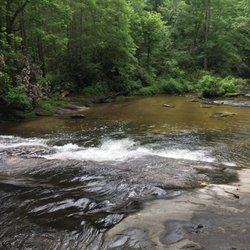
What an amazing find! Out waterfall hunting on a beautiful Saturday, Glen Falls was on my agenda for the day. Although i'm all over the georgia hiking scene, i'm just getting into North Carolina, and i'm loving what i'm seeing! Coming from highway 106, follow it north (if you're leaving the state of GA) until you see holt road. There's a often missed sign that points to Glen Falls, which leads you down Glen Falls road, which is about a 1 mile gravel trail. No worries here though, because this gravel trail is very well driven, and my honda accord took it in stride. Parking can fit about 10 or so vehicles and parking also marks two trail heads. One of those trail heads is the Glen Falls trail, which is a 1 mile in and out trail (i.e. 2 miles round trip). The other trail is the Chinquapin trail, which I didn't do today. Glen Falls will lead you down to a total of 5 viewing areas, and three absolutely beautiful cascades that each drop about 60 feet on what is the eastern fork in the blue valley area. Stops one and two are okay falls, and I really thought to myself "did I drive all the way to North Carolina for this???" Relax though, because once you hit overlook three, which gives you these wonderful twin falls, things just get better and better from there! Overlook four gives you a really nice, full waterfall that looks like a large sheet of water covering the rock face, and the fifth overlook leads to a nice little pond of water where the water empties out into. It's your own private area that's actually much more calm as far as power and intensity go. The trails themselves aren't really marked at all, outside of the trail head, but overlooks 1 through 4 all are very common sense, easy to follow trails, based on stairs and man made features. Those trails are also natural dirt trail (minus the initial gravel portion before you hit overlook 1). Going from overlook four to five was kinda annoying to me, because the trail was choked with big roots, and I was constantly watching my foot placement for fear of twisting an ankle. You do sometimes get the sense that you're losing the trail here, but when you think that, just keep an ear out for the falls. Does it sound like you're getting closer? You're not lost. If it's getting further away...yea, you're lost. The good thing is Glen Falls is a well hiked trail, and I saw several kids, parents, older adults on the trail. Before you take Glen falls on though, just keep in mind it's an all down hill trail, which is excellent going in, but coming out will make you work. Just make sure you can handle the huffing and puffing. Another excellent North Carolina Fall that doesn't disappoint the falls lover in you, and can be easily found if you're looking in the right place. As always, no cell phone service (I had AT&T), there are restrooms, and you may want to bring some extra socks because some of the trails get wet. Get out there and enjoy! read more


Highlands, NC has great waterfalls. I'm learning about them. Plus it's not too far from GA so the trip is worth it. If you travel Highway 106, you will take a sharp turn into Glen Falls Road, which is a gravel road. There is limited parking. However, you could park along side of the road. I was surprised to see two trails but hey, I'm here for Glenn Falls cause I'm obsess with waterfalls. It's 2 miles, round trip. It is easy going to the waterfalls but coming back will be a challenge since you are going downhill. There are 5 waterfalls in all. The first two were okay. I wanted more. Once we got to the third waterfall, it was amazing! You could get up close and personal! Once you get closer to the last waterfall, which is going towards a lagoon, the trail is harder cause of tree roots. Look, I have to be careful since I sprained my ankle the last time I went hiking and am still recovering. I tripped over a tree root! My ankle did start irritating going back because taking short cuts haha but it was a great workout!! I definitely had a great time! Thanks Jamarcus T for hosting another great Hiking UYE! 78/2017 read more


6 years ago
7 years ago
This is a hike to different stops to see the waterfall! It was very nice, but not sure exactly how many miles it was. The stops to see the waterfalls was breathtaking it's a must see! read more


6 years ago
Great place to go visit during these times. Beautiful scenery. The parking is not free so make sure you pay the government. But the walk around is enjoyable. read more

6 years ago
9 years ago
Lovely short hike! The place is very quite and it has a beautiful fall. All the way it has a path with stairs so it's very safe! It's important to comment that this is a downhill Trail so if you are not in good shape, you might suffer a little bit to go up! We went to the bottom of the fall and we went up in 1 hour with our Shihtzu with us! read more


8 years ago
A lot of hiking and quite a few steps, but the falls were very cool to see.. there is 3 different areas you can hike to to see the falls. read more


5 years ago
8 years ago
Glen Falls is absolutely amazing, there are several spots to stop and look at the different tiers of the falls. The trail is well maintained, except for quite a bit of mud around the viewing areas. It's a extreme decline down some nicely placed steps, but every step you take down...you have to take back up. The walk back is not for the faint at heart. read more


More info about Glen Falls Trail
1091 Glen Falls Rd
Highlands, NC 28741
Directions
Hours
Outdoor Amenities
Ask the Community - Glen Falls Trail
Review Highlights - Glen Falls Trail


Why does Yelp recommend reviews?
1 review that is not currently recommended
The reviews below are not factored into the business's overall star rating.
6 years ago
Glen Falls Trail - hiking - Updated June 2026
Best of Highlands
People found Glen Falls Trail by searching for…
Hiking Trails With Waterfalls in Highlands, North Carolina
Things to Do in Highlands, North Carolina
Off Road Trails in Highlands, North Carolina
Scenic Overlook in Highlands, North Carolina
Parks in Highlands, North Carolina
Scenic Drive in Highlands, North Carolina
Playgrounds in Highlands, North Carolina
Photo Spots in Highlands, North Carolina
Lookout Points in Highlands, North Carolina
Waterfalls in Highlands, North Carolina
Beautiful Views in Highlands, North Carolina
Day Trips in Highlands, North Carolina
Hiking With Kids in Highlands, North Carolina
Walking Trails in Highlands, North Carolina
Scenic Views in Highlands, North Carolina
Easy Hikes in Highlands, North Carolina
Places to Take Pictures in Highlands, North Carolina
Stairs Workout in Highlands, North Carolina
Jogging Trails in Highlands, North Carolina
Stair Climbing in Highlands, North Carolina
Waterfalls and Swimming Holes in Highlands, North Carolina
View Points in Highlands, North Carolina
Trending Searches in Highlands, NC
Black Owned Nail Salons near Glen Falls Trail
Blueberry Picking near Glen Falls Trail
Boat Rental near Glen Falls Trail
Cliff Jumping near Glen Falls Trail
Day Trips near Glen Falls Trail
Dog Friendly Trails near Glen Falls Trail
Fishing Spots near Glen Falls Trail
Jet Ski Rental near Glen Falls Trail
Kayak Rental near Glen Falls Trail
Off Road Trails near Glen Falls Trail
Public Shower near Glen Falls Trail
River Swimming near Glen Falls Trail
River Tubing near Glen Falls Trail
Rock Quarry near Glen Falls Trail
Scenic Overlook near Glen Falls Trail
Secluded Spots near Glen Falls Trail
Strawberry Picking near Glen Falls Trail
Swimming Holes near Glen Falls Trail
Swimming Lakes near Glen Falls Trail
U Pick Farms near Glen Falls Trail
Watch Sunset near Glen Falls Trail
Browse Articles
Browse Nearby
Browse Brands
Related Searches in Highlands, NC
Affordable Kayak Rental Services in Highlands, North Carolina
Best Fishing Locations and Guides in Highlands, North Carolina
Best Places for Horseback Riding in Highlands, North Carolina
Best Waterfalls and Swimming Holes in Highlands, North Carolina
Check Out Off Road Trails in Highlands, North Carolina
Discover Dog Friendly Trails to Explore in Highlands, North Carolina
Discover Scenic Waterfall Spots in Highlands, North Carolina
Discover Top Boat Tours in Highlands, North Carolina for All Ages
Discover a Hiking Trail in Highlands, North Carolina
Discover the Best Night Hike Trails in Highlands, North Carolina
Dog-Friendly Hikes With Dogs in Highlands, North Carolina
Enjoy Camping Adventures Around Highlands, North Carolina
Enjoy Exciting Mountain Biking Adventures in Highlands, North Carolina
Enjoy Kayaking Adventures in Highlands, North Carolina
Enjoy River Tubing Adventures in Highlands, North Carolina
Enjoy a Beautiful Waterfall Hike in Highlands, North Carolina
Enjoy the Best Tubing Experiences in Highlands, North Carolina
Enjoy the Best Walking Trails in Highlands, North Carolina
Exciting Cliff Jumping Spots in Highlands, North Carolina
Experience Thrilling White Water Rafting in Highlands, North Carolina
Explore Beautiful Parks and Green Spaces in Highlands, North Carolina
Explore Free Things to Do Around Highlands, North Carolina
Explore Fun Activities to Do in Highlands, North Carolina
Explore Popular Campgrounds Near Highlands, North Carolina
Explore Popular Scenic Overlook Points in Highlands, North Carolina
Explore Top Water Parks in Highlands, North Carolina Today
Explore the Best Boating Spots in Highlands, North Carolina
Explore the Best Swimming Holes Around Highlands, North Carolina
Family Friendly Hiking With Kids in Highlands, North Carolina
Find Beautiful Views in Highlands, North Carolina
Find Cozy Camping Cabins in Highlands, North Carolina
Find Fun Kids Activities Outdoor in Highlands, North Carolina
Find Popular Ziplining Spots Around Highlands, North Carolina
Find Top Dog Swimming Spots in Highlands, North Carolina
Find the Best Parks for Picnics in Highlands, North Carolina
Find the Best Scenic View Locations in Highlands, North Carolina
Hiking Trails With Waterfalls in Highlands, North Carolina
Off Leash Dog Hiking Trails in Highlands, North Carolina
Perfect Spots to Watch Sunset in Highlands, North Carolina
Plan a Scenic Drive Route Near Highlands, North Carolina
Popular Fishing Spots to Explore in Highlands, North Carolina
Popular Picnic Spots to Visit in Highlands, North Carolina
Popular Things to Do in Highlands, North Carolina
Safe River Swimming Areas in Highlands, North Carolina
Safe and Fun Parks for Kids in Highlands, North Carolina
Top Climbing Spots and Gyms in Highlands, North Carolina
Top Paddleboarding Activities in Highlands, North Carolina
Top Running Trails to Explore in Highlands, North Carolina
Top Swimming Lakes to Enjoy in Highlands, North Carolina
Walk Dog Friendly Hiking Trails in Highlands, North Carolina
People who viewed Glen Falls Trail also viewed
Dry Falls
83 reviews
Reedy Branch Falls Trailhead
4 reviews
Black Rock Mountain State Park
57 reviews
Lee Falls Trailhead
2 reviews
Upper Moccasin Creek Falls
2 reviews
Fall Creek Falls Trailhead
3 reviews
French Broad Falls & Mill Shoals
2 reviews
Highland Excursion
12 reviews
Big Bend Falls
1 review
Charlie Falls - Chinquapin
1 review