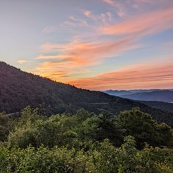
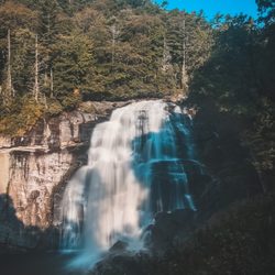
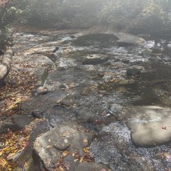
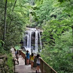
Wesser Bald Fire Tower Photos


You might also consider
More like Wesser Bald Fire Tower
Recommended Reviews - Wesser Bald Fire Tower
Start your review...

3 years ago


9 years ago
More info about Wesser Bald Fire Tower
Franklin, NC 28734
Directions
Hours
Outdoor Amenities


Wesser Bald Fire Tower - hiking - Updated July 2026
Best of Franklin
People found Wesser Bald Fire Tower by searching for…
Off Road Trails in Franklin, North Carolina
Things to Do in Franklin, North Carolina
Places to Take Pictures in Franklin, North Carolina
Hiking Trails in Franklin, North Carolina
Scenic Drive in Franklin, North Carolina
Scenic Views in Franklin, North Carolina
Hiking With Kids in Franklin, North Carolina
Walking Trails in Franklin, North Carolina
Easy Hikes in Franklin, North Carolina
Photo Spots in Franklin, North Carolina
View Points in Franklin, North Carolina
Scenic Overlook in Franklin, North Carolina
Running Trails in Franklin, North Carolina
Waterfalls in Franklin, North Carolina
Beautiful Views in Franklin, North Carolina
Trail in Franklin, North Carolina
Lookout Points in Franklin, North Carolina
Hiking Trails Kid Friendly in Franklin, North Carolina
Swimming Holes in Franklin, North Carolina
Off Leash Dog Hikes in Franklin, North Carolina
Fun Things to Do With Teens in Franklin, North Carolina
Day Trips in Franklin, North Carolina
Trending Searches in Franklin, NC
Boat Rental near Wesser Bald Fire Tower
Cliff Jumping near Wesser Bald Fire Tower
Day Trips near Wesser Bald Fire Tower
Dog Friendly Trails near Wesser Bald Fire Tower
Dog Swimming near Wesser Bald Fire Tower
Fishing Spots near Wesser Bald Fire Tower
Jet Ski Rental near Wesser Bald Fire Tower
Kayak Rental near Wesser Bald Fire Tower
Lakes near Wesser Bald Fire Tower
Off Road Trails near Wesser Bald Fire Tower
Outdoor Activities near Wesser Bald Fire Tower
Peach Picking near Wesser Bald Fire Tower
Public Shower near Wesser Bald Fire Tower
River Swimming near Wesser Bald Fire Tower
River Tubing near Wesser Bald Fire Tower
Rock Quarry near Wesser Bald Fire Tower
Running Trails near Wesser Bald Fire Tower
Scenic Overlook near Wesser Bald Fire Tower
Secluded Spots near Wesser Bald Fire Tower
Strawberry Picking near Wesser Bald Fire Tower
Swimming Holes near Wesser Bald Fire Tower
Swimming Lakes near Wesser Bald Fire Tower
U Pick Farms near Wesser Bald Fire Tower
Watch Sunset near Wesser Bald Fire Tower
Browse Articles
Browse Brands
Related Searches in Franklin, NC
Affordable Kayak Rental Services in Franklin, North Carolina
Best Dog Hiking Trails Around Franklin, North Carolina
Best Fishing Locations and Guides in Franklin, North Carolina
Best Lookout Points to Visit in Franklin, North Carolina
Best Places for Horseback Riding in Franklin, North Carolina
Best Waterfalls and Swimming Holes in Franklin, North Carolina
Check Out Off Road Trails in Franklin, North Carolina
Discover Dog Friendly Trails to Explore in Franklin, North Carolina
Discover Popular Bike Trails in Franklin, North Carolina
Discover Scenic Mountain Bike Trails Near Franklin, North Carolina
Discover a Hiking Trail in Franklin, North Carolina
Discover the Best Night Hike Trails in Franklin, North Carolina
Discover the Best Running Track in Franklin, North Carolina
Dog-Friendly Hikes With Dogs in Franklin, North Carolina
Enjoy Camping Adventures Around Franklin, North Carolina
Enjoy Exciting Mountain Biking Adventures in Franklin, North Carolina
Enjoy Kayaking Adventures in Franklin, North Carolina
Enjoy Off Leash Dog Hikes in Franklin, North Carolina
Enjoy Tent Camping Spots Around Franklin, North Carolina
Enjoy the Best Walking Trails in Franklin, North Carolina
Explore Beautiful Parks and Green Spaces in Franklin, North Carolina
Explore Easy Hikes Perfect for All in Franklin, North Carolina
Explore Fun Activities to Do in Franklin, North Carolina
Explore Popular Campgrounds Near Franklin, North Carolina
Explore Secret Spots Worth Visiting in Franklin, North Carolina
Explore Top Dog Parks in Franklin, North Carolina Near You
Explore Top Water Parks in Franklin, North Carolina Today
Explore the Best Swimming Holes Around Franklin, North Carolina
Family Friendly Hiking With Kids in Franklin, North Carolina
Find Beautiful Views in Franklin, North Carolina
Find Cozy Camping Cabins in Franklin, North Carolina
Find Popular Ziplining Spots Around Franklin, North Carolina
Find Top-Rated Waterfalls in Franklin, North Carolina Now
Hiking Trails With Waterfalls in Franklin, North Carolina
Off Leash Dog Hiking Trails in Franklin, North Carolina
Perfect Spots to Watch Sunset in Franklin, North Carolina
Plan a Scenic Drive Route Near Franklin, North Carolina
Popular Outdoor Activities to Try in Franklin, North Carolina
Popular Picnic Spots to Visit in Franklin, North Carolina
Safe River Swimming Areas in Franklin, North Carolina
Safe and Fun Parks for Kids in Franklin, North Carolina
Top Hiking Trails to Explore in Franklin, North Carolina
Top Paddleboarding Activities in Franklin, North Carolina
Top Running Trails to Explore in Franklin, North Carolina
Top Swimming Lakes to Enjoy in Franklin, North Carolina
Top Swimming Spots and Pools in Franklin, North Carolina
People who viewed Wesser Bald Fire Tower also viewed
Fires Creek Recreation Area
2 reviews
Little Tennesee River Greenway
2 reviews
Big View Scenic Outlook
2 reviews
Tom Branch Falls
16 reviews
Indian Creek Falls
2 reviews
Joyce Kilmer Memorial Forest
6 reviews
Juney Whank Falls
14 reviews
Fork Ridge Overlook
1 review
Andrews Recreation Park
2 reviews
Sliding Rock
7 reviews