The Pines Recreation Area Photos


More like The Pines Recreation Area
Recommended Reviews - The Pines Recreation Area
Start your review...

2 years ago
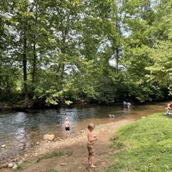
It's a beautiful spot for swimming, or to launch your kayak from. Great for picnics and it's very easy to access and handicap accessible. The con is the putrid smell from the unclean restrooms and the garbage is overflowing. I went up several times with my grandchildren and truly it was not kept up. Such a shame as it is a popular tourist and local destination. read more


Good place to visit! Duke Energy worked with the city/state/County? to build this beach/Park. Nice parking spots on both sides of the road. Bathrooms located up in the parking area. A nice ramp down all the way to the water. Seriously, you could wheel a wheelchair all the way into the lake. The sand is very nice. And you can easily swim out to and hold onto the barriers. There's a dock off to one side where you can fish off of. We'll thought out and done pretty well. They even have donated life jackets for kids hanging here at the beach! My reasons for 4 instead of 5 stars: Dogs. The path down to the beach was littered with dog poop. On the path, on the side, everywhere! It was gross and unsanitary. Don't know if dogs are allowed on the beach, but they've turned the park area to crap. The beach is quite small. I do believe too small to support all the parking. The beach is very steep. I know it's the mountains, but if you're going to drain the lake and make a beach, a gentler slope to the beach for the little ones would've been preferable. A larger swim area. Some people just want to swim! Maybe another 10 feet out into the lake for swimming, not just waking. read more


More info about The Pines Recreation Area
1965 Pine Creek Rd
Cullowhee, NC 28723
Directions
Hours
Indoor Amenities
Outdoor Amenities


The Pines Recreation Area - parks - Updated July 2026
Best of Cullowhee
People found The Pines Recreation Area by searching for…
Lakes in Cullowhee, North Carolina
Fishing in Cullowhee, North Carolina
Dog Parks in Cullowhee, North Carolina
Swimming Lakes in Cullowhee, North Carolina
Playgrounds in Cullowhee, North Carolina
Dog Swimming in Cullowhee, North Carolina
Things to Do in Cullowhee, North Carolina
Dog Friendly Beaches in Cullowhee, North Carolina
Fishing Spots in Cullowhee, North Carolina
Fishing Lake in Cullowhee, North Carolina
Hiking With Kids in Cullowhee, North Carolina
Off Road Trails in Cullowhee, North Carolina
Parks for Picnics in Cullowhee, North Carolina
Picnic Areas in Cullowhee, North Carolina
Parks for Kids in Cullowhee, North Carolina
Swimming Holes in Cullowhee, North Carolina
Dog Friendly Trails in Cullowhee, North Carolina
Picnic Spots in Cullowhee, North Carolina
Scenic Views in Cullowhee, North Carolina
Running Trails in Cullowhee, North Carolina
Lakes & Ponds in Cullowhee, North Carolina
Swimming in Cullowhee, North Carolina
Trending Searches in Cullowhee, NC
Black Owned Nail Salons in Cullowhee, NC
Cliff Jumping in Cullowhee, NC
Fishing Spots in Cullowhee, NC
Jet Ski Rental in Cullowhee, NC
Kids Activities Outdoor in Cullowhee, NC
Lookout Points in Cullowhee, NC
River Swimming in Cullowhee, NC
Scenic Overlook in Cullowhee, NC
Strawberry Picking in Cullowhee, NC
Swimming Holes in Cullowhee, NC
Swimming Lakes in Cullowhee, NC
Browse Articles
Browse Nearby
BEST of Cullowhee, North Carolina Things to Do near The Pines Recreation Area
BEST of Cullowhee, North Carolina Restaurants near The Pines Recreation Area
BEST of Cullowhee, North Carolina Coffee near The Pines Recreation Area
BEST of Cullowhee, North Carolina Hiking near The Pines Recreation Area
BEST of Cullowhee, North Carolina Breakfast near The Pines Recreation Area
BEST of Cullowhee, North Carolina Beaches near The Pines Recreation Area
BEST of Cullowhee, North Carolina Campgrounds near The Pines Recreation Area
Browse Brands
Related Searches in Cullowhee, NC
Affordable Kayak Rental Services in Cullowhee, North Carolina
Affordable Paddle Board Rental in Cullowhee, North Carolina
Best Off Leash Dog Parks in Cullowhee, North Carolina
Best Parks for Parties and Events in Cullowhee, North Carolina
Best Water Parks for Kids in Cullowhee, North Carolina
Best Waterfalls and Swimming Holes in Cullowhee, North Carolina
Check Out Great Playgrounds in Cullowhee, North Carolina
Discover Dog Friendly Beaches Near Cullowhee, North Carolina
Discover Lakes & Ponds to Explore in Cullowhee, North Carolina
Discover Popular Bike Trails in Cullowhee, North Carolina
Discover Popular Photo Spots in Cullowhee, North Carolina
Discover Scenic Beach Camping Sites in Cullowhee, North Carolina
Discover Top Boat Tours in Cullowhee, North Carolina for All Ages
Discover Top Nature Parks to Visit in Cullowhee, North Carolina
Discover Top State Parks to Visit in Cullowhee, North Carolina
Discover the Best Beaches in Cullowhee, North Carolina
Enjoy Hiking Adventures in Cullowhee, North Carolina
Enjoy Kayaking Adventures in Cullowhee, North Carolina
Enjoy the Best Walking Trails in Cullowhee, North Carolina
Experience Stunning Sunset Views in Cullowhee, North Carolina
Explore Beautiful Parks and Green Spaces in Cullowhee, North Carolina
Explore Easy Hikes Perfect for All in Cullowhee, North Carolina
Explore Family-Friendly Zoos and Wildlife in Cullowhee, North Carolina
Explore Free Picnic Areas Around Cullowhee, North Carolina
Explore Fun Activities to Do in Cullowhee, North Carolina
Explore Gyms With Pool Access in Cullowhee, North Carolina
Explore Parks With Pull Up Bars in Cullowhee, North Carolina
Explore Picnic Parks Near Cullowhee, North Carolina
Explore Popular Campgrounds Near Cullowhee, North Carolina
Explore Popular Picnic Areas Around Cullowhee, North Carolina
Explore Popular RV Parks Around Cullowhee, North Carolina
Explore Popular Scenic Views Near Cullowhee, North Carolina
Explore Scenic Lakes to Visit in Cullowhee, North Carolina
Explore Secret Spots Worth Visiting in Cullowhee, North Carolina
Explore Top Dog Parks in Cullowhee, North Carolina Near You
Explore Top Marinas Near Cullowhee, North Carolina
Explore Top Trampoline Parks in Cullowhee, North Carolina
Explore Top Water Parks in Cullowhee, North Carolina Today
Explore Volleyball Courts Available in Cullowhee, North Carolina
Explore the Best Swimming Holes Around Cullowhee, North Carolina
Find Great Places to Feed Ducks in Cullowhee, North Carolina
Find Top Dog Friendly Parks to Visit in Cullowhee, North Carolina
Find Top Skate Parks in Cullowhee, North Carolina for All Skill Levels
Find Top-Rated Waterfalls in Cullowhee, North Carolina Now
Find the Best Parks BBQ Grills in Cullowhee, North Carolina
Find the Best Parks for Picnics in Cullowhee, North Carolina
Find the Best Playgrounds to Visit in Cullowhee, North Carolina
Find the Best Swimming Pools in Cullowhee, North Carolina Today
People who viewed The Pines Recreation Area also viewed
Sliding Rock Falls
52 reviews
Caesars Head State Park
44 reviews
Waynesville Parks & Recreation
11 reviews
Dry Falls
83 reviews
Sycamore Flats
1 review
Moore Cove Falls
4 reviews
Fingerlake Day Use Area
1 review
Pisgah National Forest
74 reviews
French Broad Falls & Mill Shoals
2 reviews
Little Tennesee River Greenway
2 reviews