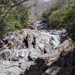
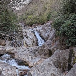
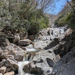
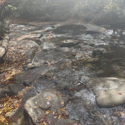
Moore Cove Falls Photos


More like Moore Cove Falls
Recommended Reviews - Moore Cove Falls
Start your review...

2 years ago
Great hike to a beautiful fall you can stand behind. Less than 1 more long. Moderately challenging. read more


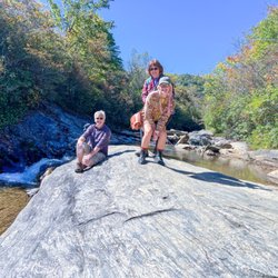
Made this trek last year and was disappointed when the water was only dribbling. After our rainy February we went back to see the grotto in all its glory. It felt like a 3/4 mile walk in. The trail has some elevation but stairs and plateaus make it manageable for most people. It's the icing on the cake after experiencing the majestic looking glass falls. read more
5 years ago
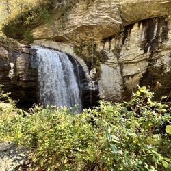
MOORE COVE FALLS is a place that should be on every waterfall enthusiasts list. Not only is it an extremely pet friendly family trail, it is well maintained and very easy to follow. This section of the Pisgah National Forest is gorgeous and the beauty of the trail will make you feel excited about life and nature. It truly feels like a blessing to be able to witness such amazing places with your own eyes. After finding a parking space in the large pull-off, follow the sidewalk south to a bridge leading over Looking Glass Creek. The trail immediately goes up a semi-steep hill for a spell, but eventually levels out. You will have an elevated view of the parking area for about 100 yards before the trail veers left into the woods. Thoughtful boardwalks are placed in areas that get a little muddy and after another slight uphill climb, you will soon after see the falls. You have a choice of walking onto the observation deck for Moore Cove Falls, heading downhill to the base (splash zone) or uphill to the cave like overhang area perfect for a family picnic. While there ARE trails leading further up to the cliffs near the crest of the falls, signs highly discourage anyone from following them. Deaths have occurred here from people who do not respect the danger of this natural wonder. NOTE: According to the topography map on ALLTRAILS, the creek begins a steep descent to the crest of the falls around 2789 feet and flows over the crest around 2600 feet, leaving about 189 feet of cascades not visible from the base of the falls. *** [ THINGS TO KNOW ] Total Hiking Distance: 1.2 miles (roundtrip) Difficulty: Easy, although the trail start off uphill Creek Crossings: YES (bridged) Elevation Gain: 165 feet Waterfall Height: about 50 feet Waterfall source: Moore Creek WATERFALL ATTRACTIVENESS - 7 out of 10 TRAIL ATTRACTIVENESS - 7 out of 10 Access to top of falls: Not recommended Access to base of falls: YES Pool of water @ base of Falls: NO Sitting areas @ base: YES RESTROOM FACILITIES: NO PARKING: YES (space for about 20-25 cars) but be forewarned, this is a VERY popular waterfall hiking trail. *** [ FINAL THOUGHTS ] MOORE COVE FALLS was our 13th waterfall of the 15 we visited in a 3 day weekend!!! It was an excellent addition to spectacular waterfall chasing weekend with the love of my life. I highly recommend this waterfall for all ages and four legged fur babies. ENJOY! 2021 / 58 read more


2 years ago
Easy to follow trail to a pretty waterfall. There is a bit of a climb, but it isn't too strenuous. The stream and woods along the trail are lovely. read more

More info about Moore Cove Falls
Moore Cove, NC 28712
Directions
Hours
Outdoor Amenities


Moore Cove Falls - hiking - Updated July 2026
Best of Moore Cove
People found Moore Cove Falls by searching for…
Swimming Holes in Moore Cove, North Carolina
Hiking Trails With Waterfalls in Moore Cove, North Carolina
Caves in Moore Cove, North Carolina
Things to Do in Moore Cove, North Carolina
Easy Hikes in Moore Cove, North Carolina
Waterfalls in Moore Cove, North Carolina
Picnic Areas in Moore Cove, North Carolina
Scenic Overlook in Moore Cove, North Carolina
Dog Friendly Trails in Moore Cove, North Carolina
Hikes With Dogs in Moore Cove, North Carolina
Lookout Points in Moore Cove, North Carolina
Stair Climbing in Moore Cove, North Carolina
Things to Do on a Rainy Day in Moore Cove, North Carolina
View Points in Moore Cove, North Carolina
Beautiful Views in Moore Cove, North Carolina
Running Trails in Moore Cove, North Carolina
Attractions in Moore Cove, North Carolina
Things to Do at Night in Moore Cove, North Carolina
Off Road Trails in Moore Cove, North Carolina
Off Leash Dog Hikes in Moore Cove, North Carolina
Scenic Views in Moore Cove, North Carolina
Boardwalk in Moore Cove, North Carolina
People who viewed Moore Cove Falls also viewed
High Falls Trailhead - Dupont State Forest
24 reviews
Upper Whitewater Falls
27 reviews
Triple Falls Trailhead - Dupont State Forest
39 reviews
Waterrock Knob
26 reviews
High Falls Trail
4 reviews
Thompson River Waterfalls
2 reviews
Connestee Falls
7 reviews
Toxaway Falls
4 reviews
Rainbow & Turtleback Falls Trailhead - Gorges State Park
3 reviews
Hooker Falls Trailhead - Dupont State Forest
19 reviews