Upper Whitewater Falls Photos


More like Upper Whitewater Falls
Recommended Reviews - Upper Whitewater Falls
Start your review...

Reviews With Photos

Absolutely gorgeous view of Upper Whitewater Falls, North Carolina. It's easy to miss the entrance to this area. Once you cross the border from South Carolina to North Carolina, it's your 2nd right turn and easy to miss the sign. The walk is short to the 1st view, about 1/2 mile. The walk to the 2nd view is down some fairly steep stairs, but well worth it and not too difficult. Such a beautiful waterfall!

Came here on a Sunday morning around 8AM, weather was a bit drizzly and it was gray, no cars in the parking lot. Walk to the falls was short, walked down the stairs to the overlook, wet due to rain but hand rails all around. Waterfall was really big, as expected since it's the tallest waterfall east of the Rockies. Lots of water too because it rained the last few days. Would recommend taking a quick look!


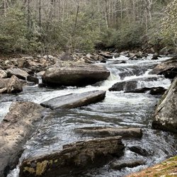
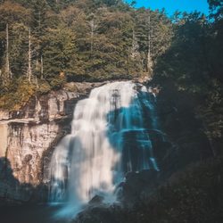
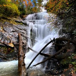
If you could visit only one waterfall in Western NC, this may be the one I'd recommend. The upper drop consists of a short cascade followed by a huge free-fall, with most of the flow on the right but a few ribbons of water also spilling down on the left. After a short run of rapids and cascades, the lower free-fall section begins and it is split as well with most of the water on the right when the water is low (it evens out more during higher flow). It ends in some cascades into a couple of rocky pools. The overall scene is wide, and dramatic, from the overlook. Some consider this the highest waterfall east of the Mississippi River. Whether or not that is true is debatable - it's even debatable as to whether what you see is even one waterfall, considering the short run of rapids between the main drops. The height has been listed in various places for many years at 411 ft. I think this might be some sort of competition with the also-overestimated Hickory Nut Falls, because it's simply not that high. Using recent USGS elevation data, I estimate it to be just a hair over 330 ft, from the rocks right at the brink to the deepest part of the pool at the bottom. You might round it up to 350 ft if you're really generous and include some of the cascades above and below the "falls" in your calculation. But it's nowhere near that 411 ft number that gets bandied about. Nevertheless, it's a very scenic and impressive waterfall, with a high water flow - the stream contains plenty of water even at lower flow!

Location is Closed. Check before you go. High School Reunion Picnic and something was going on in the Brevard, Asheville, Hendersonville area so ended up stay at the Hampton Inn in Sapphire. That worked out good because I had never had the opportunity to introduce my wife to this area. This area was part of my younger days. Transylvania Country has over 200 waterfalls and when I was younger, had photographed close to 75% of them. Anyway, got up and had breakfast and backtracked toward Lake Toxaway on US Hwy 64 till we got to the intersection with Hwy 281 where we turned South. US Park Service sign proudly announced " Whitewater Falls 9 miles" I grew up with these falls and my parents would bring me here when I was only 5 or 6 and it was a gravel road to get here. For the longest time, SC did a better job on roads because at least their road to the falls from the South was paved. Keep in mind we're talking 50 or 60 years ago. Enough for the history. We got to the Falls and sign said "closed due to fire damage to the stairs" Stopped at the Visitors Center at Gorges State Park on the way back to US 64 and I asked the attendant at the Visitors Center what was going on.She said that a wild fire in the Jocassie Gorge had damaged the Overlook and the Stairs to it back in November. Asked if they were working to repair the damage and she did not know the status but from what she had heard, it did not have a high priority and little progress had been made in the last 7 months Next question and the most telling was "Why have not posted a sign back at the exit off of US Hwy 64 informing visitors the area was closed." Her comment was,"Good Question" I get asked the same question at least 3 times a week. The trip to the Gorges State Park was the only thing that kept this from being a total waste otherwise, 9 miles in and 9 miles out would have been an 18 mile drive wasted. Hopefully at some time it will reopen. Will be back in August to find out.


Very pretty place, Hike was not too bad at all. It was a bit rainy while i was there but it did not take from the beautiful waterfall. The only worry i had was wild animals in the bushes because it was later in the day and there weren't people around. Overall thiswaterfall is one that will not disappoint and totally worth the 5-10 minute walk to the viewing area. Definitely coming back to visit when im back up in north carolina.

Very nice trail to two overlooks of the falls. The first part of the trail is paved - saw some pretty butterflies and a hummingbird in the nearby wildflowers. Second part of trail is made of brand new stairs - not very long but steep and a quick little workout. This connects to a much longer trail for serious hikers. Overall, short and sweet and easy enough for most people to do. Dog friendly. Large parking area with clean restrooms. We combined this with another short waterfall trail down the road at Gorges State Park (Bearwallow trail) for a scenic but not too strenuous morning.

Tony, Noel and I was out with our little doggie Sammi, visiting the Land of the Waterfalls and we visited UPPER WHITEWATER FALLS last. It is a lovely park. We had visited several the day before and today so we were a little tired. We were not able to hike the path to the base of the falls but definitely plan on it next time. This time we did walk out to the overlook where I was able to get some wonderful photos for my collection. There was a $2 fee to enter and park in the parking lot. Well worth it. The waterfall is protected by the Nantahala National Forest. Although some claim that Whitewater Falls is simply the tallest East of the Mississippi, that title may belong to Crabtree Falls in Virginia, depending on how one defines "waterfall". In fact, there is debate as to whether Whitewater falls is the tallest waterfall in North Carolina, as there are some in the state which may lay claim to being even taller, such as Glassmine Falls on the Blue Ridge Parkway. There is a Lower Whitewater Falls in South Carolina about 2 miles downstream from Upper Whitewater Falls.

The waterfall is beautiful. You can hear the sound of the water from the parking lot. The top view is beautiful but the view from the bottom of the stairs is even better, I recommend going down the stairs. If you take your time you can do it.. there are spots to rest on the stairway-including a bench halfway. There were people of ALL ages down on the platform.
. The lower falls are 2 miles down river in South Carolina.")
This is one huge waterfall! Located just off Hwy 281 you will find a large parking area suitable for cars, motorcycles or even RV's. A paved walking trail takes you about a quarter of a mile to the overlook. It has some vegetation that makes taking a clean pic of the falls difficult, but you can also opt to walk down the 154 steps (yes I counted) to the viewing platform. It lays claim to being the largest waterfall in the South, west of the Mississippi River. However, I'm from Georgia, home of Amicalola Falls. Whitewater falls is divided in two. The Upper falls are 411 feet while the lower falls are an additional 400 feet. My problem with this claim is the lower falls are about 2 miles downstream of the upper falls. Kinda seems like two separate fall to me. Amicalola is 729 feet from top to bottom and the winner in my humble opinion... but who's counting? THE VERDICT Oh well, either way this is a beautiful waterfall worthy of putting on your waterfall must see list. It's only about a 2 hour drive from the perimeter of Atlanta. For more really cool waterfalls, head up 281 towards Highway 64. Gorges State Park is about 8 miles away with a very nice collection of waterfalls accessible via Grassy Ridge trail. NOTES: Largest waterfalls east of the Mississippi are: Crabtree Falls in Virginia (1,200 feet) Glassmine Falls in North Carolina (over 800 feet, but is not always flowing).

Very beautiful and breathtaking waterfall! You can hear the roaring of the falls from a long distance this can tell you how big the falls are. We only did the upper falls didn't take the 154 steps down and back up to my legs being sore already from hiking two days in a row. This is a waterfall you must see. Don't forget to pay the small fee it's on a honor system, while there I didn't see anyone paying but us. This helps keep up this place.

The highest waterfall east of the Rocky Mountains, Whitewater Falls is an easy drive from Greenville, S.C., just a short distance north of the North Carolina state line. The falls themselves aren't accessible, but a paved trail and short staircase lead to an pair of overlooks that offer tremendous views. There's a large paved parking lot, with restrooms and picnic tables nearby. Definitely worth a the trip.

Beautiful falls but only gave it 4 stars because it's the kind of place that you get to it, take a picture, and leave. After walking down wooden stairs, you end up on a viewing deck. The waterfall is in the distance. It's a fairly easy hike. Getting there is easy but after you do have to walk back up the stairs but there is a bench at the halfway point to take a rest. We did this along with Silver Run Falls, 9 miles away. Both of these hikes are fairly easy and would be good for small children and/or dogs. I recommend doing both of these falls on same day because you can easily do both within 90 minutes. read more


The area is a very complicated series of different jurisdictions; this is federal land under the Fish and Wildlife Service. A parking lot has self-pay stations for a small fee (national parks passes can be displayed in your car instead). The walk to a first view is short, but if you can handle a stair workout, the resulting platform is eminently worthwhile. I've done my fair share of waterfall viewings, and you could hardly imagine a better sight than this complex cascade and the fall color show I arrived just in time for. A separate trail ran down into the valley, with signs saying there were no more waterfall views; and thus presumably no way to get to the falls directly. read more


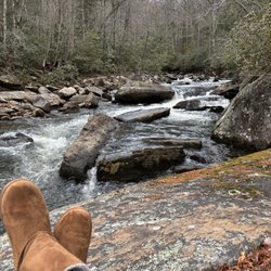
Dog, Kid, wheelchair, Hiking friendly. Forest, waterfall views. Wildflowers and wildlife. There is a fee. 1.2 Miles and an elevation of 216FT. I feel there are 3 options to the water falls. #1-So if you just want to see the waterfalls. You can just park right in that parking lot, walk down a nice paved walkway. The waterfalls are right there. (Easiest hike for any person) #2-We parked in the Parking lot next door and hiked down .5 mile trail. As this was difficult enough for some people in my party at age 60. This leads you to the Best View of the waterfalls and the 60 year old was happy enough for this. (for me this was a super easy hike) I would recommend doing it all. This leads me to #3 #3-The second part of the hike starts right at the viewing platform to the right. Starts out with a narrow winding steep incline and it does involve scrambling. I hiked down to show my sister what it was going to take and she was to nervous to head down. So we walked to the Road and walked back to the other parking lot where we were parked. (For me this is a moderate hike but I still would recommend doing it all because your there and why not read more


4 years ago
Absolutely gorgeous view of Upper Whitewater Falls, North Carolina. It's easy to miss the entrance to this area. Once you cross the border from South Carolina to North Carolina, it's your 2nd right turn and easy to miss the sign. The walk is short to the 1st view, about 1/2 mile. The walk to the 2nd view is down some fairly steep stairs, but well worth it and not too difficult. Such a beautiful waterfall! read more


Came here on a Sunday morning around 8AM, weather was a bit drizzly and it was gray, no cars in the parking lot. Walk to the falls was short, walked down the stairs to the overlook, wet due to rain but hand rails all around. Waterfall was really big, as expected since it's the tallest waterfall east of the Rockies. Lots of water too because it rained the last few days. Would recommend taking a quick look! read more

3 years ago
A BEAUTIFUL waterfall with a small hike? It's mostly stairs but the overlook is definitely worth it! read more


If you could visit only one waterfall in Western NC, this may be the one I'd recommend. The upper drop consists of a short cascade followed by a huge free-fall, with most of the flow on the right but a few ribbons of water also spilling down on the left. After a short run of rapids and cascades, the lower free-fall section begins and it is split as well with most of the water on the right when the water is low (it evens out more during higher flow). It ends in some cascades into a couple of rocky pools. The overall scene is wide, and dramatic, from the overlook. Some consider this the highest waterfall east of the Mississippi River. Whether or not that is true is debatable - it's even debatable as to whether what you see is even one waterfall, considering the short run of rapids between the main drops. The height has been listed in various places for many years at 411 ft. I think this might be some sort of competition with the also-overestimated Hickory Nut Falls, because it's simply not that high. Using recent USGS elevation data, I estimate it to be just a hair over 330 ft, from the rocks right at the brink to the deepest part of the pool at the bottom. You might round it up to 350 ft if you're really generous and include some of the cascades above and below the "falls" in your calculation. But it's nowhere near that 411 ft number that gets bandied about. Nevertheless, it's a very scenic and impressive waterfall, with a high water flow - the stream contains plenty of water even at lower flow! read more

Location is Closed. Check before you go. High School Reunion Picnic and something was going on in the Brevard, Asheville, Hendersonville area so ended up stay at the Hampton Inn in Sapphire. That worked out good because I had never had the opportunity to introduce my wife to this area. This area was part of my younger days. Transylvania Country has over 200 waterfalls and when I was younger, had photographed close to 75% of them. Anyway, got up and had breakfast and backtracked toward Lake Toxaway on US Hwy 64 till we got to the intersection with Hwy 281 where we turned South. US Park Service sign proudly announced " Whitewater Falls 9 miles" I grew up with these falls and my parents would bring me here when I was only 5 or 6 and it was a gravel road to get here. For the longest time, SC did a better job on roads because at least their road to the falls from the South was paved. Keep in mind we're talking 50 or 60 years ago. Enough for the history. We got to the Falls and sign said "closed due to fire damage to the stairs" Stopped at the Visitors Center at Gorges State Park on the way back to US 64 and I asked the attendant at the Visitors Center what was going on.She said that a wild fire in the Jocassie Gorge had damaged the Overlook and the Stairs to it back in November. Asked if they were working to repair the damage and she did not know the status but from what she had heard, it did not have a high priority and little progress had been made in the last 7 months Next question and the most telling was "Why have not posted a sign back at the exit off of US Hwy 64 informing visitors the area was closed." Her comment was,"Good Question" I get asked the same question at least 3 times a week. The trip to the Gorges State Park was the only thing that kept this from being a total waste otherwise, 9 miles in and 9 miles out would have been an 18 mile drive wasted. Hopefully at some time it will reopen. Will be back in August to find out. read more

5 years ago
This is the largest waterfall east of the Mississippi river. It is spectacular, and the overlook is an easy walk from the parking lot. The fee is $3.00 per day. It is definitely worth visiting. read more


3 years ago
4 years ago
Very pretty place, Hike was not too bad at all. It was a bit rainy while i was there but it did not take from the beautiful waterfall. The only worry i had was wild animals in the bushes because it was later in the day and there weren't people around. Overall thiswaterfall is one that will not disappoint and totally worth the 5-10 minute walk to the viewing area. Definitely coming back to visit when im back up in north carolina. read more


8 years ago
Very nice trail to two overlooks of the falls. The first part of the trail is paved - saw some pretty butterflies and a hummingbird in the nearby wildflowers. Second part of trail is made of brand new stairs - not very long but steep and a quick little workout. This connects to a much longer trail for serious hikers. Overall, short and sweet and easy enough for most people to do. Dog friendly. Large parking area with clean restrooms. We combined this with another short waterfall trail down the road at Gorges State Park (Bearwallow trail) for a scenic but not too strenuous morning. read more

10 years ago
Tony, Noel and I was out with our little doggie Sammi, visiting the Land of the Waterfalls and we visited UPPER WHITEWATER FALLS last. It is a lovely park. We had visited several the day before and today so we were a little tired. We were not able to hike the path to the base of the falls but definitely plan on it next time. This time we did walk out to the overlook where I was able to get some wonderful photos for my collection. There was a $2 fee to enter and park in the parking lot. Well worth it. The waterfall is protected by the Nantahala National Forest. Although some claim that Whitewater Falls is simply the tallest East of the Mississippi, that title may belong to Crabtree Falls in Virginia, depending on how one defines "waterfall". In fact, there is debate as to whether Whitewater falls is the tallest waterfall in North Carolina, as there are some in the state which may lay claim to being even taller, such as Glassmine Falls on the Blue Ridge Parkway. There is a Lower Whitewater Falls in South Carolina about 2 miles downstream from Upper Whitewater Falls. read more


7 years ago
The waterfall is beautiful. You can hear the sound of the water from the parking lot. The top view is beautiful but the view from the bottom of the stairs is even better, I recommend going down the stairs. If you take your time you can do it.. there are spots to rest on the stairway-including a bench halfway. There were people of ALL ages down on the platform. read more


12 years ago
This is one huge waterfall! Located just off Hwy 281 you will find a large parking area suitable for cars, motorcycles or even RV's. A paved walking trail takes you about a quarter of a mile to the overlook. It has some vegetation that makes taking a clean pic of the falls difficult, but you can also opt to walk down the 154 steps (yes I counted) to the viewing platform. It lays claim to being the largest waterfall in the South, west of the Mississippi River. However, I'm from Georgia, home of Amicalola Falls. Whitewater falls is divided in two. The Upper falls are 411 feet while the lower falls are an additional 400 feet. My problem with this claim is the lower falls are about 2 miles downstream of the upper falls. Kinda seems like two separate fall to me. Amicalola is 729 feet from top to bottom and the winner in my humble opinion... but who's counting? THE VERDICT Oh well, either way this is a beautiful waterfall worthy of putting on your waterfall must see list. It's only about a 2 hour drive from the perimeter of Atlanta. For more really cool waterfalls, head up 281 towards Highway 64. Gorges State Park is about 8 miles away with a very nice collection of waterfalls accessible via Grassy Ridge trail. NOTES: Largest waterfalls east of the Mississippi are: Crabtree Falls in Virginia (1,200 feet) Glassmine Falls in North Carolina (over 800 feet, but is not always flowing). read more
. The lower falls are 2 miles down river in South Carolina. - Hiking Near Me - Sapphire, North Carolina")


5 years ago
7 years ago
Very beautiful and breathtaking waterfall! You can hear the roaring of the falls from a long distance this can tell you how big the falls are. We only did the upper falls didn't take the 154 steps down and back up to my legs being sore already from hiking two days in a row. This is a waterfall you must see. Don't forget to pay the small fee it's on a honor system, while there I didn't see anyone paying but us. This helps keep up this place. read more


11 years ago
The highest waterfall east of the Rocky Mountains, Whitewater Falls is an easy drive from Greenville, S.C., just a short distance north of the North Carolina state line. The falls themselves aren't accessible, but a paved trail and short staircase lead to an pair of overlooks that offer tremendous views. There's a large paved parking lot, with restrooms and picnic tables nearby. Definitely worth a the trip. read more


8 years ago
I went in the winter with my family and it was beautiful. We did not go down all the way in fear that we might slip on some sleet or snow. The place has nice bathrooms and and everywhere you look there is a nice view. I highly recommend this waterfall. Amazing place! read more


11 years ago
9 years ago
10 years ago
More info about Upper Whitewater Falls
Ask the Community - Upper Whitewater Falls
Review Highlights - Upper Whitewater Falls


Why does Yelp recommend reviews?
1 review that is not currently recommended
The reviews below are not factored into the business's overall star rating.
4 years ago
Upper Whitewater Falls - hiking - Updated June 2026
Best of Sapphire
People found Upper Whitewater Falls by searching for…
Hiking Trails With Waterfalls in Sapphire, North Carolina
Scenic Overlook in Sapphire, North Carolina
Fishing in Sapphire, North Carolina
Swimming Holes in Sapphire, North Carolina
Things to Do in Sapphire, North Carolina
Parks in Sapphire, North Carolina
Scenic Drive in Sapphire, North Carolina
Picnic Areas in Sapphire, North Carolina
Waterfalls in Sapphire, North Carolina
Off Road Trails in Sapphire, North Carolina
Beautiful Views in Sapphire, North Carolina
View Points in Sapphire, North Carolina
Running Trails in Sapphire, North Carolina
Scenic Views in Sapphire, North Carolina
Walking Trails in Sapphire, North Carolina
Hiking With Kids in Sapphire, North Carolina
Dog Friendly Hiking Trails in Sapphire, North Carolina
Sunrise View in Sapphire, North Carolina
Canyoneering in Sapphire, North Carolina
Stairs Workout in Sapphire, North Carolina
Stair Climbing in Sapphire, North Carolina
Hikes With Dogs in Sapphire, North Carolina
People who viewed Upper Whitewater Falls also viewed
Daniel Ridge Falls
1 review
Pisgah National Forest
74 reviews
Reedy Branch Falls Trailhead
4 reviews
Merry Falls
1 review
Sliding Rock Falls
52 reviews
French Broad Falls & Mill Shoals
2 reviews
Fall Creek Falls Trailhead
3 reviews
Fourth Falls Trailhead
2 reviews
Charlie Falls - Chinquapin
1 review
Black Rock Mountain State Park
57 reviews