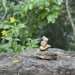
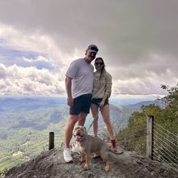
Lee Falls Trailhead Photos


More like Lee Falls Trailhead
Recommended Reviews - Lee Falls Trailhead
Start your review...

7 years ago
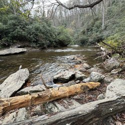
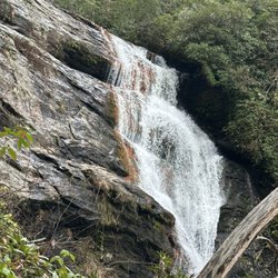
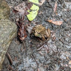
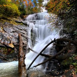
The hike to Lee Falls is similar to some relationships, beautiful and easygoing in the beginning, yet difficult and tumultuous in the end. Lee Falls sure is a pretty girl or handsome guy (depending on your preference), but man, what you have to go through to be with Lee might make you wonder if the hike is actually worth it in the end! { DRIVING NOTES } The drive to Lee Falls was a tad confusing, kinda like bumbling over words when you first introduce yourself to someone. I approached the falls heading north on Hwy 11 and then turning left onto Cheohee Valley Road. I sometimes bring a notepad with me and self drawn maps with directions just in case I lose signal or my phone battery dies. My map had me turning left off Cheohee Valley Road onto Tamassee Knob Road, which is correct. However, Tamassee Knob Road meets Cheohee Valley Road TWICE, and I was supposed to take the second left, not the first. I was taken off course slightly, but eventually found my way to the trailhead parking area. { THE HIKE } Once parked, I headed past the large gate into a field of gorgeous green grass several football fields in length. There are NO blazes on this trail to tell you where to go, however, someone did tie ribbons to trees in key spots to give some sort of direction. Sometimes the ribbons are blue, other times they were orange. At the end of the first field, you will need to cross directly through the Tamassee Creek. There is no footbridge here and you will most definitely get your shoes wet. Actually, there are a total of 6 water crossings, so wear proper shoes and bring an extra pair + socks to change into when you return to your car after the hike. After the first creek crossing, you will enter into the second of FOUR grassy fields. This field is by far the prettiest as it has an island of trees in the center. I couldn't help but wonder what it would be like to own this land and build a home here. It truly is what I would expect Hanzel & Gretel's land to look like from childhood fairy tales. A small strip of woods separates the second field from the third. At the end of the third grassy field you will cross Tamassee Creek once again before entering into the fourth and final field. It will be all forest from here, but be forewarned: the trail will become more difficult to follow the closer you get to the falls. This literally is the part of your relationship with Lee where you start to have doubts, but you fight through them to make the relationship work! --- Once you cross the creek for the 6th time, the hike takes a turn from pleasant (grassy fields), then confusing (forest) to outright difficult (the final climb). Each step you make will be heavily calculated and your route to the falls will be determined by your own security. The trail becomes undefined and you will scramble over rocks, huge boulders, downed trees and through the creek itself to make your way to the falls. Talk about relationship obstacles! Although the falls are easily within view, it is an uphill battle to get to the best viewing area. It is very likely you will need to stop and catch your breath. It is this part of my relationship with Lee Falls that I wondered if all of this fighting to be together was worth it. But I pressed on, determined to make it work! { THE FALLS } Once you reach a satisfactory viewing area, take a snack & water break! You have truly earned it! Soak in the sights and sounds of nature as you stare 70 feet up at Lee Falls in all its mossy beauty. Truly one of the most unique waterfalls I've ever seen in the South. My favorite spot was leaning against a large boulder in the middle of the river. Oddly as I looked down I caught the remains of a frog trapped in between two stones. "I feel you bro" I whispered. { FINAL THOUGHTS } I spent about 15 minutes with Lee regaining my strength before saying my farewell and heading back to my car. The return down the boulders was no less difficult, but at least I could walk though the woods more confidently than I did when I first encountered the difficult to follow trail. It's so true that difficulties make you smarter & stronger. The trail to Lee certainly took me through the ringer, but I emerged wiser from the experience nonetheless. It was a short fling that I will always remember. SCOUTING NOTES: * The parking area along 715A is to the right just before you cross the creek. *Parking area can easily handle a dozen or more cars. * Road to the parking area is gravel, but smooth. * Some parts of the FIRST grassy field can be really muddy. Best not to follow the path through the grass. Instead stay close to the treeline on the left for this field. * Trail is approximately 1.5 miles in length to the falls. The first half is super easy & pleasant. * Pack a lunch! You're gonna want to stay here for a while. * Bring extra shoes & socks to change into after the hike. Several crossings have ankle deep water. * NO RESTROOMS * NO PARKING FEES 2019/45 read more


7 years ago
This is the most unique trail that I have ever hiked! The parking lot is pretty small and there are no parking fees. The trail starts at a gate connected to the first of many grassy fields that you have to pass through. This is the part that didn't seem like most trails I've done. It was mostly tall grass, but there was a beaten path that you could find and walk on. Even though it was beautiful, it was in direct sunlight, so depending on the season and time of day, you could be a little warm and easily sunburn if you are not prepared! There are also a handful of water crossings, so wear Chocos or bring another pair of socks and shoes. This is not a trail for the weak! Or for people who prefer a nice, well laid out pathway. I barely noticed trail markers or blaze markers. It is kind of hard to follow at times. The trail was very narrow and full of foliage. There is no way to avoid the plants touching you. Some kind of plant that is similar to poison ivy was everywhere and made me itch like crazy. But once I got to one of the water crossings, I was able to wash my legs off and feel better. Once you get closer to the waterfall, you have to almost rock climb and navigate through a really rocky area to make it to the top of the falls. But all of this was worth it when you finally reach the falls. WOW. It is huge! And there are several spots to rest on the rocks as you take in this lovely view. There are no bathrooms, so make sure you stop somewhere before you get there. read more


More info about Lee Falls Trailhead
Government Rd 715A
Tamassee, SC 29686
Directions
Hours
Outdoor Amenities


Lee Falls Trailhead - hiking - Updated July 2026
Best of Tamassee
People found Lee Falls Trailhead by searching for…
Hiking Trails With Waterfalls in Tamassee, SC
Off Road Trails in Tamassee, SC
Beautiful Views in Tamassee, SC
Waterfalls and Swimming Holes in Tamassee, SC
Walking Trails in Tamassee, SC
Running Trails in Tamassee, SC
Natural Hot Springs in Tamassee, SC
Free Things to Do in Tamassee, SC
Fun Things to Do in Tamassee, SC
Off Leash Dog Hikes in Tamassee, SC
Scenic Overlook in Tamassee, SC
Lookout Points in Tamassee, SC
Browse Nearby
Browse Brands
Browse Articles
People who viewed Lee Falls Trailhead also viewed
Todd Creek Falls
4 reviews
Station Cove Falls
11 reviews
Rabun Bald via Beegum Gap Trail
10 reviews
Fall Creek Falls Trailhead
3 reviews
Brasstown Falls
4 reviews
Glen Falls Trail
17 reviews
Rainbow & Turtleback Falls Trailhead - Gorges State Park
3 reviews
Secret Falls
3 reviews
Cullasaja Falls
4 reviews
Toxaway Falls
4 reviews