Martin Creek Falls Photos


More like Martin Creek Falls
Recommended Reviews - Martin Creek Falls
Start your review...

8 years ago
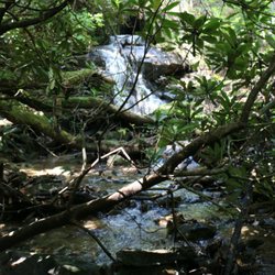
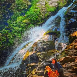
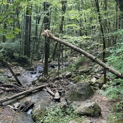
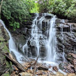
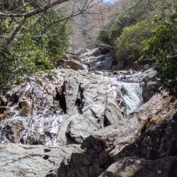
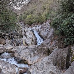
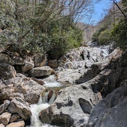
Martin Creek Falls is a beautiful secluded waterfall in Clayton, GA near Warwoman Dell. It is part of the Chattahoochee National Forest that encompasses the entire Northeast corner of the state of Georgia. The forest itself is 750,145 acres and is so large that it is divided into regions. Martin Creek is located in the Chattooga River District and specifically in Rabun County, whom incorporates the largest portion of the National Forest. 148,684 acres of this massive forest system lie within Rabun County borders. Depending on how much you like hiking, you can get to Martin Creek Falls on a short 1/2 mile hike via Finney Creek Road or a longer 2 mile hike (one way) from Warwoman Dell via the Bartram Trail. If you choose to hike from Warwoman Dell, your extra effort will be rewarded with two additional waterfalls as well as a loop trail highlighting the history of the area. Becky Branch Falls is located near the trailhead at Warwoman Dell and an additional unnamed waterfall is about 1/4 mile south of Martin Creek Falls. Only about 8 feet tall, but it's multiple levels make it a beauty. Martin Creek Falls is one of the prettier waterfalls in North Georgia. It is a multi-tiered waterfall that looks as if it goes on forever from the base. It is also one of the few waterfalls that I wish the vegetation would be cut away to make the full view of the falls visible. From the deck at its base you can see the largest drop, but the upper tiers become more difficult to see as vegetation near the middle tier blocks the view. Still, it is a gorgeous waterfall that makes wandering in this neck of the woods an incredibly satisfying adventure. The lower part of the falls are shaded while the upper part is sunny, so bring a UV filter (which I forgot) for best DSLR results. DIRECTIONS From US-23 (Hwy 441) in Clayton, Georgia travel east on Rickman Road. In 1/2 a mile it will merge into Warwoman Road. 2.5 miles from here you will pass the parking entrance to Warwoman Dell, which is difficult to see, but look for a small brown sign with a picnic table symbol and turn right. You can either park here and take Bartram Trail to the falls (about 2 miles one way) OR continue along Warwoman Road to Finney Creek Road. Approximate address for Finney Creek Road is 3742 Warwoman Rd, Clayton, GA 30525. TURN LEFT. It is a gravel road across from an open grassy field. The trailhead to the falls is approximately 1.1 miles from Warwoman Road or approximately 1/2 mile from the Wildlife Management Check-In station that you will pass along Finney Creek Road. Hike from this trailhead to the falls is approximately 1/2 mile round trip. Recommended for families with young children as they can also splash around in the pool of water at the waterfalls base, so bring their swimsuits and ENJOY! 2018/54 read more


More info about Martin Creek Falls
400 Kelly's Creek Rd
Ste 201
Rabun Gap, GA 30568
Directions
Hours
Outdoor Amenities


Martin Creek Falls - hiking - Updated May 2026
Best of Rabun Gap
People found Martin Creek Falls by searching for…
Hiking Trails With Waterfalls in Rabun Gap, Georgia
Things to Do in Rabun Gap, Georgia
Waterfalls in Rabun Gap, Georgia
Waterfalls and Swimming Holes in Rabun Gap, Georgia
Easy Hikes in Rabun Gap, Georgia
Beautiful Views in Rabun Gap, Georgia
Lookout Points in Rabun Gap, Georgia
Picnic Areas in Rabun Gap, Georgia
Scenic Overlook in Rabun Gap, Georgia
Walking Trails in Rabun Gap, Georgia
Secluded Spots in Rabun Gap, Georgia
Picnic Spots in Rabun Gap, Georgia
Running Trails in Rabun Gap, Georgia
Off Road Trails in Rabun Gap, Georgia
View Points in Rabun Gap, Georgia
Parks for Picnics in Rabun Gap, Georgia
Off Leash Dog Hikes in Rabun Gap, Georgia
Scenic Views in Rabun Gap, Georgia
Hiking Trails Kid Friendly in Rabun Gap, Georgia
Stuff to Do in Rabun Gap, Georgia
Browse Nearby
Browse Brands
Browse Articles
People who viewed Martin Creek Falls also viewed
Dukes Creek Falls Trail
50 reviews
High Shoals Falls Loop Trail
17 reviews
Panther Creek Recreation Area
37 reviews
Upper Moccasin Creek Falls
2 reviews
Mount Yonah Trailhead
37 reviews
Smithgall Woods
10 reviews
Lookout Rock
1 review
Big Bend Falls
1 review
Stovall Mill Covered Bridge
9 reviews
Brasstown Bald Tower
3 reviews