Becky Branch Falls Photos


More like Becky Branch Falls
Recommended Reviews - Becky Branch Falls
Start your review...

8 years ago
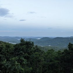
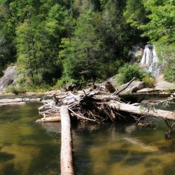
Those looking for a short waterfall hike will appreciate Becky Branch Falls. It is approximately a half mile hike round trip from the Warwoman Dell parking area to the falls via Bartram Trail. It can be easily viewed from a small bridge that crosses directly in front of the 20' waterfall. If you are feeling more adventurous, you can continue along Bartram Trail another 1.8 miles to Martin Creek Falls. It is mostly downhill, so the hike there is easy until you must return along the same path. Still, for the most part the trail is not terribly strenuous in any area. I walked this trail with a father and his 6 year old daughter that I met in the Warwoman Dell parking area. This tiny little lady easily conquered the trail, although I'm not sure how she handled the return trip since they stayed to swim in the pool of water at the base of Martin Creek Falls. The trail passes another waterfall that I don't believe has a name. It is a beautiful 8 foot multitiered waterfall, but it's not the big show! Travel approximately 1/3rd of a mile further past this fall to reach Martin Creek Falls. Believe me, it is worth the extra hike. THE AREA However, if you choose to only visit Becky Branch Falls, then be sure to check out the interactive trail through Warwoman Dell. Lots of informative signs will tell you about the area and the woman for whom it is named, Nancy Ward. Pronounced Nanye-hi, this Chreokee woman (whom belonged to the Wolf Clan) fought against the Creek Indians with her Cherokee husband. He was killed in battle, yet Nanye-hi rallied to lead her fellow Cherokees and defeated the Creeks. She was given the prestigious title of Ghighau (Beloved Woman) by her clan, which in turn gave her a council voice regarding decisions of war and peace. She eventually met and married an English trader by the name of Bryant Ward and spent the rest of her days trying to make peace between the Cherokee Nation and the Settlers. SOURCE: Scenic USA - Georgia The trail is a 1.5 mile loop that highlights the variety of plants such as the vast array of ferns, wildflowers and rhododendrons. This I believe is a nod to John Bartram (considered America's first botanist), Father of William Bartram of whom Bartram Trail is named. The trail is also said to have a beautiful scenic overlook, but I was honestly too tired to fully walk the loop trail to discover the view after my waterfall hike. Also along the trail is evidence of 18th century plans to build a railroad through this area. The bed for the railroad can still be seen in Warwoman Dell. FINAL THOUGHTS Family friendly hike that encompasses a lot of the things I love about being out in nature: Waterfalls, scenic views, beautiful plants and historic sites. I can only imagine what this trail looks like in the Spring when the rhododendrons are in bloom. 2018/53 read more


More info about Becky Branch Falls
Warwoman Dell
Clayton, GA 30525
Directions
Hours
Outdoor Amenities


Becky Branch Falls - hiking - Updated July 2026
Best of Clayton
People found Becky Branch Falls by searching for…
Hiking Trails With Waterfalls in Clayton, Georgia
Things to Do in Clayton, Georgia
Waterfalls in Clayton, Georgia
Lookout Points in Clayton, Georgia
Waterfalls and Swimming Holes in Clayton, Georgia
Scenic Overlook in Clayton, Georgia
Easy Hikes in Clayton, Georgia
Places to Take Pictures in Clayton, Georgia
Scenic Night View in Clayton, Georgia
Sunset View in Clayton, Georgia
Hiking With Kids in Clayton, Georgia
Beautiful Views in Clayton, Georgia
Walking Trails in Clayton, Georgia
Historical Sites in Clayton, Georgia
Fun Things to Do With Kids in Clayton, Georgia
View Points in Clayton, Georgia
Photo Spots in Clayton, Georgia
Scenic Drive in Clayton, Georgia
Kid Friendly in Clayton, Georgia
Public Services & Government in Clayton, Georgia
Browse Articles
Browse Nearby
Browse Brands
Trending Searches in Clayton, GA
Black Owned Nail Salons in Clayton, GA
Dog Friendly Trails in Clayton, GA
Historical Sites in Clayton, GA
Landmarks & Historical Buildings in Clayton, GA
Off Road Trails in Clayton, GA
Outdoor Activities in Clayton, GA
Scenic Overlook in Clayton, GA
Scenic Restaurants in Clayton, GA
People who viewed Becky Branch Falls also viewed
Martin Creek Falls
3 reviews
Dukes Creek Falls Trail
50 reviews
Anna Ruby Falls
203 reviews
High Shoals Falls Loop Trail
17 reviews
Panther Creek Recreation Area
37 reviews
Mount Yonah Trailhead
37 reviews
Upper Moccasin Creek Falls
2 reviews
Helton Creek Falls
42 reviews
Cowrock Summit
1 review
Reedy Branch Falls Trailhead
4 reviews