Upper Moccasin Creek Falls Photos


More like Upper Moccasin Creek Falls
Recommended Reviews - Upper Moccasin Creek Falls
Start your review...

6 years ago
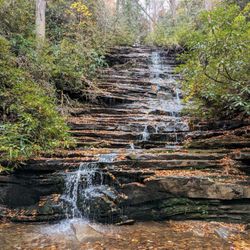
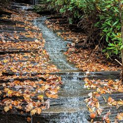
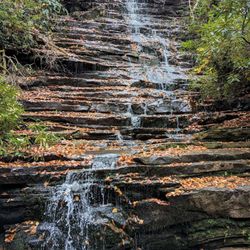
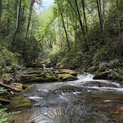
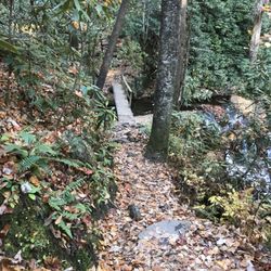
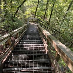
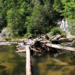
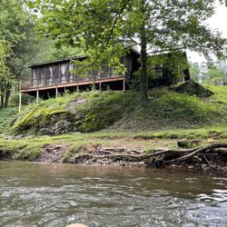
Upper Moccasin Creek Falls is a true hidden treasure. If waterfalls were rated on attractiveness, this one would be a 10!!! ~~~ THE EXPERIENCE You start out on the Hemlock Falls Trail. The trail follows Moccasin Creek closely for its entire length to the falls. The beauty of Moccasin Creek is that nearly all of it is fast flowing water, loaded with endless cascades and multiple waterfalls. You will see at least a dozen waterfalls before you even reach Upper Moccasin Creek Falls. This is due to the river dropping from 2800 feet elevation to 1868 feet elevation on its way to Lake Burton. That's over 932 feet in a 5 mile stretch. There are around 7 falls between 8-12 feet tall and many more that are only 5-8 feet tall, but gorgeous in their own right. My visit was after a 4 day period of rainfall that saturated everything north of Atlanta in Georgia, so the water volume was great. Also, this sort of saturation spawns several other waterfalls that would likely be dry in a less rainy seasons. We found THREE large ribbon-like waterfalls at least 35-50' in height just off the trail looking into the woods. They were not on Moccasin Creek itself, but acted as tributaries [a river or stream flowing into a larger river or body of water]. There is even a small 5 foot waterfall directly on the trail. ~~~ UPPER MOCCASIN CREEK FALLS On my first attempt I was defeated trying to make it to this 2nd waterfall, which is a gorgeous 40' drop upstream. I tried to follow the trail past Hemlock Falls, but did not realize you must cross through Moccasin Creek about 50 yards past the crest of the falls. Once on the other side of the creek you will pick up a faint trail that keeps you above the river most of the 3/4 of a mile journey. I CAN'T STRESS ENOUGH that you MUST CROSS through the creek above Hemlock Falls. On my first attempt a few weeks prior, I did not cross through the creek and went as far as I could before reaching an impenetrable rhododendron patch. To reach Upper Moccasin Creek Falls, the creek must be on your right side, not your left. * * * NOTE - The trail to Upper Moccasin Creek Falls is considerably more difficult than the first half of the trail to Hemlock Falls. The trail is not too hard to follow, but it can be hard to see at times if you aren't familiar with hiking. Also, it can be very dangerous in some areas because sheer drops of 30-50 feet are only one footstep away. You will have to climb over and around lots of downed trees. * * * WEAR SHOES WITH GRIP, otherwise don't bother with this trail on days after recent rainfall. Once you reach the falls, we found the easiest trail down to the base was closest to the top of the falls. I regret not using a small spur trail to visit the top of the falls while heading down to the base. Satellite images on Google Earth show what looks like another smaller waterfall or cascade just above Upper Moccasin Creek Falls. ~~~ [ THINGS TO KNOW ] Hiking Distance: 3.5 miles (roundtrip) Difficulty: Moderate (I do not recommend for children under 12 or elderly) Creek Crossings: YES (1 bridged & 1 directly though Moccasin Creek) Elevation Gain: 752 feet Waterfall Height: Approx 40 feet Access to top of falls: YES Access to base of falls: YES Pool of water @ base of Falls: YES Sitting areas @ base: YES RESTROOMS: NO PARKING: YES (12+ cars) ~~~ FINAL THOUGHTS Upper Moccasin Creek Falls is one of the most attractive waterfalls I've seen on one of the most attractive rivers in the state. It is full of cascades and secondary waterfalls to delight the ears and dazzle the eyes. But it is not for the casual walker, it requires a little skill and spirit of adventure. It is not terribly difficult, but it also is not for the faint of heart. ENJOY! 2020 / 17 read more


 - Hiking Near Me")
6 years ago
If I knew that Upper Moccasin Creek Falls was as pretty as it ended up being, I would have visited it sooner when I paid Hemlock Falls Trail a visit a couple years back! So lets start there. To even reach Upper Moccasin Creek falls, you first need to get yourself to Hemlock falls Trail, which is right across the street from Moccasin Creek State park. Drive on into the Hemlock falls trail, which turns into dirt/gravel road. There'll be a trail parking lot and a noticeable trail that ultimately takes you to Hemlock Falls, which is about a mile to Hemlock falls. If you make it to Hemlock falls, which is a fine waterfall, that's just fine! However, if you want to see a much bigger, larger and "whoa" worthy falls, take the trail to just to the right of the opening that leads you to Hemlock. First things first, and this is a cautionary tale from Richard R. If you want to get to Upper Moccasin Creek falls, you have to cross the flowing water above Hemlock falls so that the creek is on your right. Yep, the water feeding hemlock is what you need to cross. When we did cross it it ended up being for us, just about knee deep (I'm 6'1"). Once you cross over, the trail to Upper Moccasin Creek is easily able to follow, but while easy to follow, understand it's also much more challenging than the trail to Hemlock. While more challenging, it's not overbearing or impossible to do. It is slippery, muddy at times, which sucks because the trail sometimes narrows to some pretty large drops you don't want to be a victim of. Heading to the actual falls requires you going down a steep decline to a large set of rocks that rest right in front of the falls. Stand on this (CAREFULLY) and bask at the glory. The actual waterfall is roughly 40 feet, and it crashes powerfully into a pool just at the bottom of the falls. Can you swim in the pool? I don't see why not but I didn't. You can't take bad photos here and while it was tiresome to get here, I think it was worth it. This is coming from a guy who does NOT like getting wet on hikes. Just over 3 miles is the round trip of this hike, and again while the trail to hemlock is not so bad, Upper Moccasin is a bit more of a challenge. I don't recommend tackling this by yourself. Long story short, the falls here were beautiful, which includes Hemlock falls. If you're in this area and you want to see a really beautiful fall that requires some work to get to it, do yourself a favor and check it out! read more


More info about Upper Moccasin Creek Falls
Clarkesville, GA 30523
Directions
Hours
Outdoor Amenities


Upper Moccasin Creek Falls - hiking - Updated July 2026
Best of Clarkesville
People found Upper Moccasin Creek Falls by searching for…
Hiking Trails With Waterfalls in Clarkesville, GA
Things to Do in Clarkesville, GA
Attractions in Clarkesville, GA
River Swimming in Clarkesville, GA
Easy Hikes in Clarkesville, GA
Waterfalls and Swimming Holes in Clarkesville, GA
Secret Spots in Clarkesville, GA
Off Road Trails in Clarkesville, GA
Waterfalls in Clarkesville, GA
Running Trails in Clarkesville, GA
Secluded Spots in Clarkesville, GA
Walking Trails in Clarkesville, GA
Off Leash Dog Hikes in Clarkesville, GA
Hiking Trails Kid Friendly in Clarkesville, GA
Swimming Lakes in Clarkesville, GA
Beautiful Views in Clarkesville, GA
State Parks in Clarkesville, GA
Things to Do on a Rainy Day in Clarkesville, GA
Trending Searches in Clarkesville, GA
Black Owned Nail Salons near Upper Moccasin Creek Falls
Boat Rental near Upper Moccasin Creek Falls
Cliff Jumping near Upper Moccasin Creek Falls
Day Trips near Upper Moccasin Creek Falls
Dog Friendly Trails near Upper Moccasin Creek Falls
Free Picnic Areas near Upper Moccasin Creek Falls
Jet Ski Rental near Upper Moccasin Creek Falls
Kayak Rental near Upper Moccasin Creek Falls
Lakes & Ponds near Upper Moccasin Creek Falls
Off Road Trails near Upper Moccasin Creek Falls
Outdoor Activities near Upper Moccasin Creek Falls
Picnic Spots near Upper Moccasin Creek Falls
Places To Swim near Upper Moccasin Creek Falls
Public Pools near Upper Moccasin Creek Falls
Public Shower near Upper Moccasin Creek Falls
River Swimming near Upper Moccasin Creek Falls
River Tubing near Upper Moccasin Creek Falls
Rock Quarry near Upper Moccasin Creek Falls
Running Trails near Upper Moccasin Creek Falls
Scenic Overlook near Upper Moccasin Creek Falls
Soccer Store near Upper Moccasin Creek Falls
Splash Pad near Upper Moccasin Creek Falls
Swimming Holes near Upper Moccasin Creek Falls
Swimming Lakes near Upper Moccasin Creek Falls
Watch Sunset near Upper Moccasin Creek Falls
Browse Articles
Browse Brands
Related Searches in Clarkesville, GA
Affordable Kayak Rental Services in Clarkesville, Georgia
Best Fishing Locations and Guides in Clarkesville, Georgia
Best Places for Horseback Riding in Clarkesville, Georgia
Best Waterfalls and Swimming Holes in Clarkesville, Georgia
Check Out Off Road Trails in Clarkesville, Georgia
Discover Dog Friendly Trails to Explore in Clarkesville, Georgia
Discover a Hiking Trail in Clarkesville, Georgia
Discover the Best Night Hike Trails in Clarkesville, Georgia
Discover the Best Running Track in Clarkesville, Georgia
Enjoy Exciting Mountain Biking Adventures in Clarkesville, Georgia
Enjoy Tent Camping Spots Around Clarkesville, Georgia
Enjoy the Best Tubing Experiences in Clarkesville, Georgia
Enjoy the Best Walking Trails in Clarkesville, Georgia
Exciting Cliff Jumping Spots in Clarkesville, Georgia
Experience Thrilling White Water Rafting in Clarkesville, Georgia
Explore Beautiful Parks and Green Spaces in Clarkesville, Georgia
Explore Bike Rentals Throughout Clarkesville, Georgia
Explore Easy Hikes Perfect for All in Clarkesville, Georgia
Explore Fun Activities to Do in Clarkesville, Georgia
Explore Popular Campgrounds Near Clarkesville, Georgia
Explore Popular RV Parks Around Clarkesville, Georgia
Explore Popular Scenic Overlook Points in Clarkesville, Georgia
Explore Scenic Lakes to Visit in Clarkesville, Georgia
Explore Top Dog Parks in Clarkesville, Georgia Near You
Explore Top Water Parks in Clarkesville, Georgia Today
Explore the Best Boating Spots in Clarkesville, Georgia
Explore the Best Swimming Holes Around Clarkesville, Georgia
Find Beautiful Views in Clarkesville, Georgia
Find Cozy Camping Cabins in Clarkesville, Georgia
Find Parks and Recreation Activities in Clarkesville, Georgia
Find Popular Ziplining Spots Around Clarkesville, Georgia
Find the Best Playgrounds to Visit in Clarkesville, Georgia
Find the Best Scenic View Locations in Clarkesville, Georgia
Hiking Trails With Waterfalls in Clarkesville, Georgia
Off Leash Dog Hiking Trails in Clarkesville, Georgia
Plan a Scenic Drive Route Near Clarkesville, Georgia
Popular Fishing Spots to Explore in Clarkesville, Georgia
Popular Kids Activities in Clarkesville, Georgia
Popular Outdoor Activities to Try in Clarkesville, Georgia
Popular Picnic Spots to Visit in Clarkesville, Georgia
Popular Things to Do in Clarkesville, Georgia
Safe River Swimming Areas in Clarkesville, Georgia
Safe and Fun Parks for Kids in Clarkesville, Georgia
Top Climbing Spots and Gyms in Clarkesville, Georgia
Top Paddleboarding Activities in Clarkesville, Georgia
Top Running Trails to Explore in Clarkesville, Georgia
Top Swimming Lakes to Enjoy in Clarkesville, Georgia
Top Swimming Spots and Pools in Clarkesville, Georgia