Dick's Creek Falls Photos

 - Parks Near Me - Clayton, Georgia")


You might also consider
More like Dick's Creek Falls
Recommended Reviews - Dick's Creek Falls
Start your review...

8 years ago
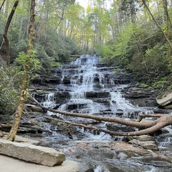
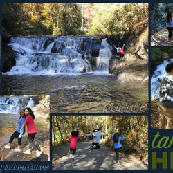
There are two things about Georgia that make me scratch my head. One would be some of the old laws that are still on the books here, such as: 1) It is illegal to keep a donkey in a bathtub. 2) No one may carry an ice cream cone in their back pocket on a Sunday. 3) In Atlanta, it is against the law to tie a giraffe to a telephone pole or street lamp. WHAT'S IN A NAME? The other thing that makes me scratch my head is how notorious Georgia is for having several places with the same name. Metro Atlanta has over 200 streets with the name Peachtree. Also, if you are looking at a map leading to THIS waterfall, you will notice a town by the name of Pine Mountain in the upper right corner of the state. However, there is also a town by the same name one hour south of Atlanta. Similarly, there are two Dick's Creek (as if one weren't enough) and both have waterfalls bearing their name. The other is "smaller", located about 55 miles east of these falls and is a gorgeous 20-foot multi-tiered waterfall with a swimming hole at the base of the final drop. It is (in my opinion) one of the best-looking waterfalls in Georgia and no hiking required to reach it. You can practically park on the upper tier and find your way down to the swimming hole below. A small waterfall that proves its how you use it that counts. THE HIKE THIS Dick's Creek Falls (located in Rabun County) is much taller @ 60' and looks like a giant Slip n' Slide. To get to the waterfall you must travel Sandy Ford Road until it intersects with the Bartram Trail. Follow the trail north until you cross Dick's Creek. Turn right after crossing the first foot bridge and when you see a second foot bridge on your right, cross it also and continue to follow the trail straight. There will be a small opening on the right side of the trail that leads you to the top of the falls. The vantage point here will allow you to see upstream of the Chattooga River. Continue a few hundred feet down the trail to find an opening that leads you into the Chattooga River. I did not find a direct trail to the base of the falls, but from this opening expect to get your feet wet! You must get wet IF you want a great photo of the falls. But don't fret, the view downstream and upstream on the river is actually more beautiful than the waterfall itself. The river bends and cascades 100 yards from the base of the falls and creates a very unique photo opportunity. The Chattooga River was not deep or raging the day I visited, so the current was mild. It only came as high as my thigh as I crossed over the weirdly hairy stones and a sandy bottom, which I suppose is where Sandy Ford Road gets its name. Upstream I could see kayakers approaching and on the dry boulders near the rivers bend there were sunbathers. The most attractive thing about Dick's Creek Falls is the area surrounding the falls is simply one of the best looking of any of the waterfalls I've been to in the state. Picturesque is the only world that comes to mind. NOTES: While driving to the trailhead, if you stay on Sandy Ford Road past the trail entrance it will lead to a beach-like area off the Chattooga River. This area is downstream of the falls. Also, there are only three places a vehicle could park comfortably near the trailhead. [ DIRECTIONS ] From US-23 (Hwy 441) in Clayton, Georgia travel east on Rickman Road. In 1/2 a mile it will merge into Warwoman Road. 5.3 miles from here make a slight right onto Sandy Ford Road. Stay right and follow it down to the small concrete bridge over Warwoman Creek. Stay on this road approximately 3.2 miles to the Bartram Trailhead (you will see wooden signs). Follow the trailhead to the left of the road as you drove in. The trail to the right will take you back to Warwoman Dell and NOT towards the falls. Once on the trail, make a sharp right after you cross the first foot bridge then another right when you see a second footbridge and follow the sounds of rushing water. Overall trail is about 1.2 miles round trip and not very steep. FINAL THOUGHTS A beautiful waterfall and a even more beautiful natural area to bring the family on a hike (and play in the water). Just know there is no easy way to get a full and unobstructed photo of the falls without walking out into the Chattooga River. I did see what seemed to be an unsanctioned side trail to the base, but it was steep and didn't at all look safe. Another option would be to bring your own kayak and launch from further upstream. Here also is a link to the OTHER Dick's Creek Falls just in case you have a little more adventure in you after your visit: https://www.yelp.com/biz/dicks-creek-falls-cleveland?osq=Dick%27s+Creek+Falls 2018/56 read more


 - Parks Near Me - Clayton, Georgia")


11 years ago
Just a few miles from the relatively busy streets of Clayton is the trailhead to this beautiful waterfall. It's rare to find such a place of impressive natural beauty that is so undiscovered, yet requires less than a mile of easy hiking to reach. While you can certainly continue on to the more moderate (and much longer) Bartram Trail, the hike to Dick's Creek Falls is accessible to even the most novice hikers. While the Falls don't really photograph well from the trail, they're quite large and impressive, at over 60 feet tall. The Falls create some natural rock slides and a large, calm lake like area at the base, that looked perfect for swimming (though I doubt that that's encouraged/allowed, we did see some hikers taking part). There are lots of great rock outcroppings for picnics, though no formal facilities. To reach the trailhead, take Warwoman Road from Clayton, Georgia east. Turn right on Sandy Ford Rd and follow the narrow dirt road utill you reach a spot where a creek flows over the road. It's right before this little ford area that you'll see a small parking area for the trail. read more

More info about Dick's Creek Falls
Sandy Ford Rd
Clayton, GA 30525
Directions
(706) 782-3320
Call Now
Hours
Outdoor Amenities


Dick's Creek Falls - parks - Updated July 2026
Best of Clayton
People found Dick's Creek Falls by searching for…
Swimming Holes in Clayton, Georgia
Hiking Trails With Waterfalls in Clayton, Georgia
River Swimming in Clayton, Georgia
Swimming Lakes in Clayton, Georgia
Places to Swim in Clayton, Georgia
Off Road Trails in Clayton, Georgia
Photo Spots in Clayton, Georgia
Playgrounds in Clayton, Georgia
Picnic Areas in Clayton, Georgia
Waterfalls in Clayton, Georgia
Attractions in Clayton, Georgia
Beautiful Views in Clayton, Georgia
Walking Trails in Clayton, Georgia
Parks for Picnics in Clayton, Georgia
Secret Spots in Clayton, Georgia
Scenic Views in Clayton, Georgia
Picnic Spots in Clayton, Georgia
Easy Hikes in Clayton, Georgia
Places to Take Pictures in Clayton, Georgia
Trending Searches in Clayton, GA
Black Owned Nail Salons near Dick's Creek Falls
Boat Rental near Dick's Creek Falls
Cliff Jumping near Dick's Creek Falls
Day Trips near Dick's Creek Falls
Dog Friendly Beaches near Dick's Creek Falls
Fireworks near Dick's Creek Falls
Fishing Spots near Dick's Creek Falls
Free Picnic Areas near Dick's Creek Falls
Jet Ski Rental near Dick's Creek Falls
Kayak Rental near Dick's Creek Falls
Kids Activities Outdoor near Dick's Creek Falls
Places To Swim near Dick's Creek Falls
Public Pools near Dick's Creek Falls
River Swimming near Dick's Creek Falls
Splash Pad near Dick's Creek Falls
Strawberry Picking near Dick's Creek Falls
Swimming Holes near Dick's Creek Falls
Swimming Lakes near Dick's Creek Falls
Things To Do With Kids near Dick's Creek Falls
Browse Articles
Browse Nearby
Browse Brands
Related Searches in Clayton, GA
Best Parks for Parties and Events in Clayton, Georgia
Best Water Parks for Kids in Clayton, Georgia
Best Waterfalls and Swimming Holes in Clayton, Georgia
Check Out Great Playgrounds in Clayton, Georgia
Check Out Off Road Trails in Clayton, Georgia
Discover Baseball Fields Around Clayton, Georgia
Discover Beautiful Garden Spots in Clayton, Georgia
Discover Popular Photo Spots in Clayton, Georgia
Discover Top Nature Parks to Visit in Clayton, Georgia
Discover the Best Beaches in Clayton, Georgia
Enjoy the Best Picnic Spots and Ideas in Clayton, Georgia
Enjoy the Best Walking Trails in Clayton, Georgia
Explore Beautiful Botanical Gardens in Clayton, Georgia
Explore Easy Hikes Perfect for All in Clayton, Georgia
Explore Family-Friendly Zoos and Wildlife in Clayton, Georgia
Explore Free Picnic Areas Around Clayton, Georgia
Explore Fun Activities to Do in Clayton, Georgia
Explore Parks With Pull Up Bars in Clayton, Georgia
Explore Popular Campgrounds Near Clayton, Georgia
Explore Popular Picnic Areas Around Clayton, Georgia
Explore Popular RV Parks Around Clayton, Georgia
Explore Popular Scenic Overlook Points in Clayton, Georgia
Explore Popular Scenic Views Near Clayton, Georgia
Explore Scenic Lakes to Visit in Clayton, Georgia
Explore Top Dog Parks in Clayton, Georgia Near You
Explore Top Gyms in Clayton, Georgia Now
Explore the Best Swimming Holes Around Clayton, Georgia
Find Parks and Recreation Activities in Clayton, Georgia
Find Top Skate Parks in Clayton, Georgia for All Skill Levels
Find Top Skating Rinks in Clayton, Georgia for All Ages
Find Top-Rated Waterfalls in Clayton, Georgia Now
Find a Park With BBQ Pits in Clayton, Georgia
Find the Best Parks BBQ Grills in Clayton, Georgia
Find the Best Parks for Picnics in Clayton, Georgia
Find the Best Swimming Pools in Clayton, Georgia Today
Fun Things for Kids in Clayton, Georgia
Have Fun at a Splash Pad in Clayton, Georgia
Hiking Trails With Waterfalls in Clayton, Georgia
Indoor Playgrounds to Explore in Clayton, Georgia
Must-See Tourist Attractions Around Clayton, Georgia
Parks With Basketball Courts for Games in Clayton, Georgia
Popular Fishing Spots to Explore in Clayton, Georgia
Popular Kids Activities in Clayton, Georgia
Popular Places to Take Pictures in Clayton, Georgia
Popular Things to Do in Clayton, Georgia
Top Hiking Trails to Explore in Clayton, Georgia
Top Swimming Lakes to Enjoy in Clayton, Georgia
Top-Rated Basketball Courts to Play at in Clayton, Georgia
People who viewed Dick's Creek Falls also viewed
Martin Creek Falls
3 reviews
Panther Creek Recreation Area
37 reviews
Black Rock Mountain State Park
57 reviews
Big Bend Falls
1 review
Soquee River Falls - Grandpa Watts Mill
1 review
Reedy Branch Falls Trailhead
4 reviews
Upper Moccasin Creek Falls
2 reviews
Chau Ram County Park
15 reviews
Stovall Mill Covered Bridge
9 reviews
Fall Creek Falls Trailhead
3 reviews