Stovall Mill Covered Bridge Photos


More like Stovall Mill Covered Bridge
Recommended Reviews - Stovall Mill Covered Bridge
Start your review...

Reviews With Photos
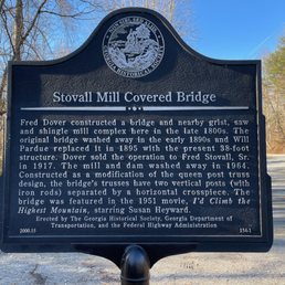

Stovall Mill is the second smallest known covered bridge in the State of Georgia. I've been on a quest to visit all of the covered bridges remaining in our state and I am happy to check another one off my list. Built in 1895, this bridge has seen better days. It is currently riddled with graffiti and seems to be in poor condition. It is just shy of 37 feet long and spans Chickamauga Creek. The smallest covered bridge is actually Blind Susie in Lula, GA (approx. 36 miles away). During my quest I have discovered several more than the 15 covered bridges I found listed on Wikipedia. My top 5 favorites-to-date are: -- Red Oak Creek Bridge - http://www.yelp.com/biz/red-oak-creek-covered-bridge-woodbury?hrid=CavIunzkcdi5LPRW9vDS-A -- Stone Mountain Covered Bridge - http://www.yelp.com/biz/stone-mountain-covered-bridge-stone-mountain?hrid=1ZxoLxg21z3lxl58tqaKyw -- George L. Smith State Park Covered Bridge - http://www.yelp.com/biz/george-l-smith-state-park-twin-city?hrid=9q1_0Df6Lv9qKnxrfLxyaw -- Old Roswell Mill Park Covered Bridge - http://www.yelp.com/biz/old-mill-park-roswell?hrid=0v9S6jT106-Rf4yBXJf0Wg -- Watson Mill Covered Bridge - http://www.yelp.com/biz/watson-mill-bridge-state-park-comer-2?hrid=wsV8FC0rGvFIoXYT6lQ1pA The Historic Marker reads: Fred Dover constructed a bridge and nearby grist, saw and shingle mill complex here in the late 1800's. The original bridge washed away in the early 1890's and Will Pardue replaced it in 1895 with the present 38-foot structure. Dover sold the operation to Fred Stovall, Sr. in 1917. The mill and dam washed away in 1964. Constructed as a modification of the queen post truss design, the bridge's trusses have two vertical posts (with iron rods) separated by a horizontal crosspiece. The bridge was featured in the 1951 movie 'I'd Climb the Highest Mountain' starring Susan Heyward. FINAL THOUGHTS Not what you would hope to see when looking for historic treasures, but at least it still stands. So many of the covered bridges have been destroyed by nature or vandals and lost forever. This entire area has a bunch of historic relics, like the Indian mounds nearby. So come and make a day of it exploring.

1 month ago
Graffiti covered bridge overlooking a cute little ravine that locals seem to enjoy and even fish in, but very difficult to pull in and (eeek!) out of and not really worth the time and gas to see a trashed covered bridge that was probably beautiful once upon a time.... Sigh. read more


2 years ago
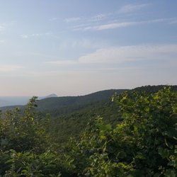
A nice covered bridge that is easy to find and walk across. There are numerous attractions in the Georgia mountains area and this is an easy one to visit and access. It is right off the main road and easy to find (and see) from the highway. There are gravel parking lots with 2 stone picnic tables and bear-proof trashcans on both sides of the bridge. So it would be good for a picnic. There is a fair amount of shade and trees near the edge of the parking lot and over the bridge and stream. There is an informational sign that you can read on the west side. The sign describes the history of the bridge and includes an appearance in the 1950 movie, "I'd Climb the Highest Mountain" starring Susan Heyward. The bridge is open to the public 24 hours and you can walk across the bridge and view it from both sides. The bridge construction is solid and explained on the sign. Unfortunately, it is covered in graffiti. The adventurous visitors can hike a few feet down to the river below the bridge and see from that new viewpoint. It is worth the trip if you can get there. read more

This relic of our not-so-distant past is a pleasant, short stopover easily found on the backroads of Northern Georgia. Unfortunately, it is in a state of disrepair and has been vandalized by graffiti makers. It's worth a stop. read more


2 years ago
12 years ago
Stovall Mill is the second smallest known covered bridge in the State of Georgia. I've been on a quest to visit all of the covered bridges remaining in our state and I am happy to check another one off my list. Built in 1895, this bridge has seen better days. It is currently riddled with graffiti and seems to be in poor condition. It is just shy of 37 feet long and spans Chickamauga Creek. The smallest covered bridge is actually Blind Susie in Lula, GA (approx. 36 miles away). During my quest I have discovered several more than the 15 covered bridges I found listed on Wikipedia. My top 5 favorites-to-date are: -- Red Oak Creek Bridge - http://www.yelp.com/biz/red-oak-creek-covered-bridge-woodbury?hrid=CavIunzkcdi5LPRW9vDS-A -- Stone Mountain Covered Bridge - http://www.yelp.com/biz/stone-mountain-covered-bridge-stone-mountain?hrid=1ZxoLxg21z3lxl58tqaKyw -- George L. Smith State Park Covered Bridge - http://www.yelp.com/biz/george-l-smith-state-park-twin-city?hrid=9q1_0Df6Lv9qKnxrfLxyaw -- Old Roswell Mill Park Covered Bridge - http://www.yelp.com/biz/old-mill-park-roswell?hrid=0v9S6jT106-Rf4yBXJf0Wg -- Watson Mill Covered Bridge - http://www.yelp.com/biz/watson-mill-bridge-state-park-comer-2?hrid=wsV8FC0rGvFIoXYT6lQ1pA The Historic Marker reads: Fred Dover constructed a bridge and nearby grist, saw and shingle mill complex here in the late 1800's. The original bridge washed away in the early 1890's and Will Pardue replaced it in 1895 with the present 38-foot structure. Dover sold the operation to Fred Stovall, Sr. in 1917. The mill and dam washed away in 1964. Constructed as a modification of the queen post truss design, the bridge's trusses have two vertical posts (with iron rods) separated by a horizontal crosspiece. The bridge was featured in the 1951 movie 'I'd Climb the Highest Mountain' starring Susan Heyward. FINAL THOUGHTS Not what you would hope to see when looking for historic treasures, but at least it still stands. So many of the covered bridges have been destroyed by nature or vandals and lost forever. This entire area has a bunch of historic relics, like the Indian mounds nearby. So come and make a day of it exploring. read more


. - Hiking Near Me - Sautee Nacoochee, Georgia")


10 years ago
A sad little bridge Stovall Mill Covered Bridge is indeed sad looking. Richard R, the expert on covered bridges, went over all the specifics and history in his review so I won't be redundant. It is indeed small and certainly does look well over a hundred years. Perhaps the most depressing thing about the bridge is all the idiotic graffiti than idiotic knuckleheads covered it with. Too bad they can't stick to highway bridges or sides of railroad cars. To cover a literally irreplaceable part of history is just so pathetic and sad. The bridge is still strong enough so you can walk over it and check out the construction and the view of the river is nice. Perhaps the bridge's most interesting feature is that it's so small. Hopefully the state will get around to fixing it up and restoring it to original condition. And hopefully the knuckleheads with spray paint will stay away from it. read more


6 years ago
8 years ago
More info about Stovall Mill Covered Bridge
Old Sautee Store On Hwy 255
Sautee Nacoochee, GA 30571
Directions
(800) 858-8027
Call Now
Hours
Outdoor Amenities
Ask the Community - Stovall Mill Covered Bridge


Stovall Mill Covered Bridge - hiking - Updated May 2026
Best of Sautee Nacoochee
People found Stovall Mill Covered Bridge by searching for…
Parks in Sautee Nacoochee, Georgia
Things to Do in Sautee Nacoochee, Georgia
Scenic Overlook in Sautee Nacoochee, Georgia
Off Road Trails in Sautee Nacoochee, Georgia
Beautiful Views in Sautee Nacoochee, Georgia
Lookout Points in Sautee Nacoochee, Georgia
River Swimming in Sautee Nacoochee, Georgia
Hiking Trails in Sautee Nacoochee, Georgia
Easy Hikes in Sautee Nacoochee, Georgia
Picnic Areas in Sautee Nacoochee, Georgia
Bridge in Sautee Nacoochee, Georgia
Historical Sites in Sautee Nacoochee, Georgia
Running Trails in Sautee Nacoochee, Georgia
Fishing in Sautee Nacoochee, Georgia
Scenic Drive in Sautee Nacoochee, Georgia
Waterfalls in Sautee Nacoochee, Georgia
Train in Sautee Nacoochee, Georgia
Arts & Entertainment in Sautee Nacoochee, Georgia
Things to See in Sautee Nacoochee, Georgia
Places to Take Pictures in Sautee Nacoochee, Georgia
State Park in Sautee Nacoochee, Georgia
Picnic Spots in Sautee Nacoochee, Georgia
Browse Nearby
BEST of Sautee Nacoochee, Georgia Restaurants near Stovall Mill Covered Bridge
BEST of Sautee Nacoochee, Georgia Things to Do near Stovall Mill Covered Bridge
BEST of Sautee Nacoochee, Georgia Coffee near Stovall Mill Covered Bridge
BEST of Sautee Nacoochee, Georgia Breakfast near Stovall Mill Covered Bridge
BEST of Sautee Nacoochee, Georgia Wineries near Stovall Mill Covered Bridge
Browse Brands
Browse Articles
People who viewed Stovall Mill Covered Bridge also viewed
Stonewall Creek Falls
2 reviews
Nacoochee Indian Mound
5 reviews
Martin Creek Falls
3 reviews
Upper Moccasin Creek Falls
2 reviews
Unicoi Hill Park
3 reviews
Moccasin Creek State Park
8 reviews
Dick's Creek Falls
3 reviews
Lake Chatuge
9 reviews
Soquee River Falls - Grandpa Watts Mill
1 review
Currahee Mountain
4 reviews