Mount Yonah Trailhead Photos


More like Mount Yonah Trailhead
Recommended Reviews - Mount Yonah Trailhead
Start your review...

Reviews With Photos

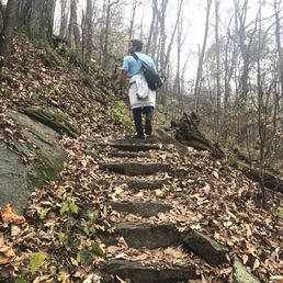
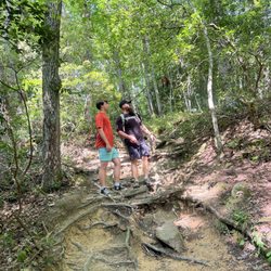
------THE TRAIL ------ This hike is not for the young, the old and the weak. It starts off tough going uphill and your legs will beg you to turn back around to the safety of your car. I saw little kids on the hike and I don't know if they are just more fit than I will ever be or if their superhuman parents somehow carried them up. The trail does get easier after the beginning but some parts are incredibly steep. Most everyone else had huge hiking backpacks (like they were about to summit Everest) and I don't think those are necessary because while it's a tough hike, it's not only for advanced hikers. The average Joe could complete the hike but there will be some parts that are challenging. The views are amazing. You can see the parking lot from the summit and if you have good eyesight, even spot your car. Please don't stand near the edge or try to go onto that rock that juts out for a picture. The fall is dangerous and people have died. The summit also had some icy parts near the edges. The way down is easy because it is all downhill but forget about social distancing because some parts are narrow and you will be in close contact with others. I left the summit at 11 am and lots of people were coming up at that time. The entire hike was 4.5 miles and took 2 hours and 30 min with rests on random rocks in between. ------LOCATION/PARKING------ If you put "Yonah Mountain" into your GPS, you will end up in front of a private road with a sign that says "Hikers do not enter". Put "Yonah Mountain Trailhead". The parking lot is just dirt and gravel so when you turn in and it looks like you are about to drive into the woods into the middle of nowhere, just keep driving and you will find the other cars at the end near the questionable looking restrooms. Please don't bring your nice car. Bring a car that you are fine with driving over rocks and into mini potholes. The lot only had about 10 other cars at 9 am but when I left at 12 pm, it was full and people had to park far away from the trailhead. -----TIPS------ - Wear hiking boots (not sneakers because those have no traction) unless you are looking for a mud bath because you will slip and fall into the mud on your way down -Bring water (more than you think you need) - You can fake a picture at the edge if you sit on the ones that jut out but have other ledges right under - Wear multiple layers (it gets colder as you go up)


Popular undeveloped trail with awesome views! We hiked Mount Yonah Trail on a partly sunny Labor Day Monday. We arrived about 11:15am. This is a difficult rated trail, about 4.5 miles round trip and 1500ft+ elevation gain. This trail has sparse neon green cut out blazes nailed to trees. Hiking, rock climbing, limited camping and dogs on leash. No trash bins - Pack OUT please! *Not for people with fear of heights and knees and ankle sensitivity. * ++ Undeveloped trail! No pavements. Decent rocky trail (if you like rocks and boulders). The trail itself is rocky but more so on the 2nd mile up. It's canopied with a clearing at ~ 1 mile and also at ~ 1.85 mile, the granite cliffs near the summit. - Very popular with everybody and their brother. I expected less people b/c it's rated hard. It felt more like Stone Mountain traffic with many people lacking hiking etiquettes, not picking up after their dogs and themselves. = 2 outhouses at the trail head and another about 2/3 of way up at a US army training camp. It's NOT pleasant so take care prior to arrival. ++ Fantastic views of the valley and nearby peaks from the granite cliffs at 1.85 miles to the right of the trail. This is NOT the summit but most people stop hiking here. - Traffic at the lookout. There were about 30 people here before 1pm. Anchors and bolts on boulders, likely from army training and rock climbers. + There were some rock climbers at the bottom of a steep cliff (less than 1 pitch, looked to be ~5.6 to 5.9). ++ Grassy open tree ringed Summit with few (fcfc) campsites / fire pits. There were only 7 people here! Slightly below the summit was another boulder cliff where we were above some birds soaring thermals. = Parking is free but tight. Very rough gravel hill to the lot. There were at least 50 cars when we arrived and saw additional 30-40 parked along the tight dirt road on our way out. Overall, I found this continuous ascent trail to be moderate and one of the best in Georgia. The negatives were waaaay too many people. The positives were several rock scrambles close to the summit and reward vistas at 1.85 mile and just below the summit. Maybe an earlier AM hike on a non-holiday next time for less traffic!

Definitely not the easiest trek, but if you're up for a little adventure and challenge this is the place you want to hike. Getting there depending where you are located may or may not be a drive it really depends on the part of the state you are from. Also you will get to a side dirt road, that's the actual entrance to the parking lot of the trail. It looks sketchy but that's the correct route to take. Avoid if it just rained, it's possible for your car to get stuck in the mud there. Once you are on the actual mountain trail and beginning your hike, be prepared ahead of time. Bring good hiking shoes. You will be going through some tough terrain and you could easily roll an ankle if not careful. Stay hydrated, bring a decent amount of water for the journey up and down. The entire hike is probably close to 2-3 hours depending how well you pace yourself. The trail is marked out but color tags on trees only for a portion of the trail the rest you just have to pay attention to how the ground is laid out. Stick to the trail, do not wander off, people have died doing that here. Most of the trail you are surrounded by trees and at times it can be really steep or narrow. There are some really great sites to see on the mountain, bring a camera! Overall, it sounds hard but it's really fun and it will test you but in a good way. I recommend this for anyone who wants to try it. Nature lovers will love this place. It's just you and mother nature out there!

Length: 4.4 Miles Difficulty: Moderate to moderately difficult. You're hiking up a mountain. It can be steep at times and the trail is very rocky, you won't find any pavement here. The trail itself is 90% shaded on the way to the top so this hike is pretty manageable during the hottest days of summer. Dog Friendly: Yes. A couple of large rocks that your dog will have to climb or hop over. Some parts are pretty rocky and rough on paws. Sights: Fairly pedestrian on the way up but there are a couple lookout points after the halfway mark. The views at the top are phenomenal, you get a very expansive view of the rolling landscape. It's worth the hike. FYI: Drive slow on the path to the trailhead. Very rough and contains large dips - you'll bottom out if your car is low. Summary: Not quite a favorite but it's one of the closer trails to Atlanta, only 1.5 hours away. A good hike if you're looking to get a workout and rewarding view at the end.


This is one of my favorite local hikes. Anyone can do it WITH THE RIGHT MINDSET. You have to remember you are going straight up a mountain. It isn't exactly beginners; that's why I said with the right mindset anyone can do it. If it is 20 degrees, you are going to still be breaking a sweat. The top is breathtaking, and definitely worth it. I recommend it to anyone that is willing to put in the work for it.


Let me start off by saying it was a challenging hike, but well worth it. My friend told me I had to input coordinates to find the trail (34.637383, -83.725117) otherwise you can end up at any point around the mountain. The length of the hike (to and from) is about 4-5 miles. I am a beginner hiker and in average shape. I had to take breaks often throughout the hike, so with breaks the hike in total took about 2 hours. The trail can get very narrow and steep. There are lots of rocks and tree branches sticking out of the ground, so be careful as it is easy to trip. Be sure to wear proper shoes as the path can get slippery and bring plenty of water! It's important to note that the dirt path leading up to the trail site was rough! I recommend taking a four wheel drive if you can. Besides that the views were great especially when you get to the top.

This is a separate mountain that isn't park of any of the massive park areas in the Appalachians nearby. The trailhead is at the end of a short gravel road that was bumpy; navigable with a sedan but not ideal. The hike is woodsy and not highly difficult, but the cumulative effect after a couple of miles is significant. I found a meadow short of the peak which was sufficient for my interest. It had some nice views. Wildlife included a woodchuck and a substantial snail population. This area was considerably less crowded than the bigger mountains or the tourist town nearby. It wasn't anything mind-blowing, but it's a good outdoor activity. read more


The trail is only 2 miles long, but small part of it can be considered easy, most parts are rocky, some parts are steep. Normal trails take me 20 minutes for a mile, but this time it took me 80 minutes to get to the top. But reward is the beautiful views at the top. There are many tents and hammock setups at the small flat area on the peak. There are many branches along the trail with no sign, which are normally various shortcuts to the top, usually means steep, stay on trail with green marks. People were doing all kinds of yoga posting on the edges of rocks, it's nice but I personally don't think it worth the risk. Parking lot is small, expect to park along the way to trailhead. People brought climbing gears and lined up for serious climbing. According to a sign, this also is US military climbing training area. read more


------THE TRAIL ------ This hike is not for the young, the old and the weak. It starts off tough going uphill and your legs will beg you to turn back around to the safety of your car. I saw little kids on the hike and I don't know if they are just more fit than I will ever be or if their superhuman parents somehow carried them up. The trail does get easier after the beginning but some parts are incredibly steep. Most everyone else had huge hiking backpacks (like they were about to summit Everest) and I don't think those are necessary because while it's a tough hike, it's not only for advanced hikers. The average Joe could complete the hike but there will be some parts that are challenging. The views are amazing. You can see the parking lot from the summit and if you have good eyesight, even spot your car. Please don't stand near the edge or try to go onto that rock that juts out for a picture. The fall is dangerous and people have died. The summit also had some icy parts near the edges. The way down is easy because it is all downhill but forget about social distancing because some parts are narrow and you will be in close contact with others. I left the summit at 11 am and lots of people were coming up at that time. The entire hike was 4.5 miles and took 2 hours and 30 min with rests on random rocks in between. ------LOCATION/PARKING------ If you put "Yonah Mountain" into your GPS, you will end up in front of a private road with a sign that says "Hikers do not enter". Put "Yonah Mountain Trailhead". The parking lot is just dirt and gravel so when you turn in and it looks like you are about to drive into the woods into the middle of nowhere, just keep driving and you will find the other cars at the end near the questionable looking restrooms. Please don't bring your nice car. Bring a car that you are fine with driving over rocks and into mini potholes. The lot only had about 10 other cars at 9 am but when I left at 12 pm, it was full and people had to park far away from the trailhead. -----TIPS------ - Wear hiking boots (not sneakers because those have no traction) unless you are looking for a mud bath because you will slip and fall into the mud on your way down -Bring water (more than you think you need) - You can fake a picture at the edge if you sit on the ones that jut out but have other ledges right under - Wear multiple layers (it gets colder as you go up) read more


9 years ago
Popular undeveloped trail with awesome views! We hiked Mount Yonah Trail on a partly sunny Labor Day Monday. We arrived about 11:15am. This is a difficult rated trail, about 4.5 miles round trip and 1500ft+ elevation gain. This trail has sparse neon green cut out blazes nailed to trees. Hiking, rock climbing, limited camping and dogs on leash. No trash bins - Pack OUT please! *Not for people with fear of heights and knees and ankle sensitivity. * ++ Undeveloped trail! No pavements. Decent rocky trail (if you like rocks and boulders). The trail itself is rocky but more so on the 2nd mile up. It's canopied with a clearing at ~ 1 mile and also at ~ 1.85 mile, the granite cliffs near the summit. - Very popular with everybody and their brother. I expected less people b/c it's rated hard. It felt more like Stone Mountain traffic with many people lacking hiking etiquettes, not picking up after their dogs and themselves. = 2 outhouses at the trail head and another about 2/3 of way up at a US army training camp. It's NOT pleasant so take care prior to arrival. ++ Fantastic views of the valley and nearby peaks from the granite cliffs at 1.85 miles to the right of the trail. This is NOT the summit but most people stop hiking here. - Traffic at the lookout. There were about 30 people here before 1pm. Anchors and bolts on boulders, likely from army training and rock climbers. + There were some rock climbers at the bottom of a steep cliff (less than 1 pitch, looked to be ~5.6 to 5.9). ++ Grassy open tree ringed Summit with few (fcfc) campsites / fire pits. There were only 7 people here! Slightly below the summit was another boulder cliff where we were above some birds soaring thermals. = Parking is free but tight. Very rough gravel hill to the lot. There were at least 50 cars when we arrived and saw additional 30-40 parked along the tight dirt road on our way out. Overall, I found this continuous ascent trail to be moderate and one of the best in Georgia. The negatives were waaaay too many people. The positives were several rock scrambles close to the summit and reward vistas at 1.85 mile and just below the summit. Maybe an earlier AM hike on a non-holiday next time for less traffic! read more


3 years ago
5 years ago
3 years ago
4 years ago
Definitely not the easiest trek, but if you're up for a little adventure and challenge this is the place you want to hike. Getting there depending where you are located may or may not be a drive it really depends on the part of the state you are from. Also you will get to a side dirt road, that's the actual entrance to the parking lot of the trail. It looks sketchy but that's the correct route to take. Avoid if it just rained, it's possible for your car to get stuck in the mud there. Once you are on the actual mountain trail and beginning your hike, be prepared ahead of time. Bring good hiking shoes. You will be going through some tough terrain and you could easily roll an ankle if not careful. Stay hydrated, bring a decent amount of water for the journey up and down. The entire hike is probably close to 2-3 hours depending how well you pace yourself. The trail is marked out but color tags on trees only for a portion of the trail the rest you just have to pay attention to how the ground is laid out. Stick to the trail, do not wander off, people have died doing that here. Most of the trail you are surrounded by trees and at times it can be really steep or narrow. There are some really great sites to see on the mountain, bring a camera! Overall, it sounds hard but it's really fun and it will test you but in a good way. I recommend this for anyone who wants to try it. Nature lovers will love this place. It's just you and mother nature out there! read more


7 years ago
Length: 4.4 Miles Difficulty: Moderate to moderately difficult. You're hiking up a mountain. It can be steep at times and the trail is very rocky, you won't find any pavement here. The trail itself is 90% shaded on the way to the top so this hike is pretty manageable during the hottest days of summer. Dog Friendly: Yes. A couple of large rocks that your dog will have to climb or hop over. Some parts are pretty rocky and rough on paws. Sights: Fairly pedestrian on the way up but there are a couple lookout points after the halfway mark. The views at the top are phenomenal, you get a very expansive view of the rolling landscape. It's worth the hike. FYI: Drive slow on the path to the trailhead. Very rough and contains large dips - you'll bottom out if your car is low. Summary: Not quite a favorite but it's one of the closer trails to Atlanta, only 1.5 hours away. A good hike if you're looking to get a workout and rewarding view at the end. read more

6 years ago
It was a challenge but well worth it! Lots of rocks and some slippery mud along the way! Great work out for sure. Took us 1 1/2 hours to reach the top and 45 min to come back down. read more


5 years ago
Amazing hike and worth every step of the way! Take a lot of snacks and wear anti slip shoes. read more


3 years ago
This is one of my favorite local hikes. Anyone can do it WITH THE RIGHT MINDSET. You have to remember you are going straight up a mountain. It isn't exactly beginners; that's why I said with the right mindset anyone can do it. If it is 20 degrees, you are going to still be breaking a sweat. The top is breathtaking, and definitely worth it. I recommend it to anyone that is willing to put in the work for it. read more

5 years ago
7 years ago
I've been going to this mountain or the last 10 years and it doesn't get much easier. The view, however, seems to be nicer every time I've gone. If you haven't already, you have to check out this trail in Cleveland, GA. read more

6 years ago
Let me start off by saying it was a challenging hike, but well worth it. My friend told me I had to input coordinates to find the trail (34.637383, -83.725117) otherwise you can end up at any point around the mountain. The length of the hike (to and from) is about 4-5 miles. I am a beginner hiker and in average shape. I had to take breaks often throughout the hike, so with breaks the hike in total took about 2 hours. The trail can get very narrow and steep. There are lots of rocks and tree branches sticking out of the ground, so be careful as it is easy to trip. Be sure to wear proper shoes as the path can get slippery and bring plenty of water! It's important to note that the dirt path leading up to the trail site was rough! I recommend taking a four wheel drive if you can. Besides that the views were great especially when you get to the top. read more

6 years ago
Awesome trail. Might be too steep for beginners. Nice views. Only 10 mins drive from Helen. read more

This hike was crazy! I am a Floridian, and therefore walking on anything that is not flat is already quite the challenge for me. I'm pretty fit, but there were random people surpassing me and Boyfriend so fast, it was making me question just how good my endurance is. The entire hike feels like walking on a stair master. It took us about 2-2.5 hours to get to the peak. The peak was a foggy, windy, rainy mess. It was so awesome. I couldn't see over the edge because the fog was glaring back at me, but the experience felt like an Alice in Wonderland mixed with Blair Witch Project moment. As I walked, the world was tilting because I was on the edge of the mountain. We felt victorious when we reached the top because it wasn't as easy as we thought it would be. I would say it's probably considered a moderate hike so don't think by my Floridian description that this is a hard hike. The hike down was a lot faster since gravity is basically rolling you down the mountain. We just got a bit worried about slips and slides because of the rain. read more

8 years ago
5 years ago
8 years ago
Great place to take a family if you have older children( age 10 and up) the hike to the top of the mountain is over two miles and gets very strenuous and is not for the faint at heart. It is worth it once you get to the top the views are amazing. read more


6 years ago
Beautiful beautiful view! A must see if you are in the area! The trail is pretty difficult if you are not prepared for steep uphill climb. Also downhill can be tough on knees because of grade. My husband and I are hikers so we enjoyed the challenge to the top. We grabbed a stick for the way down and it made the down grade easier to navigate. Highly recommend bringing a hiking pole or stick if you have one. It's shaded most of the trail which makes it nice in all kind of weather. We encountered a rain storm during our hike which made the rocks slippery so our stick became resourceful again. Follow the green markings on trees and download the All Trails map if you can bc some parts can be hard to follow. read more

16 years ago
Beautiful hiking trails that wind up and around Mount Yonah. This 3,166ft tall Mountain has approximately 2.5 miles of trails that start from a well signed trailhead parking lot. There are restroom facilities in the parking lot, and also about halfway up the trail towards the summit. The summit is cleared and grassy, but is ringed in trees, obscuring the view. The best views are from the Southern rock faces just below the actual summit. read more


12 years ago
Really nice hike. Pretty strenuous though, especially after you reach the grassy clearing half way up. The view at the top of the mountain is totally worth the extra effort. Take plenty of water, especially if you take a dog because there is only one stream at the very beginning. read more

11 years ago
Free fun. Great, clean, ez - moderate trail. I was recommended this hike by a friend. Could be better marked, but it is easy to find your way. 2 miles up and 2 miles down. Most of the two is wide for hiking. Good shoes is all you need. read more

6 years ago
11 years ago
Great hike. Went up in the winter and it has snow on top. The view was great and overall, the hike was easy. Highly recommend. read more

9 years ago
Visited: 11/05/2016 Considering other trails I've been on, I definitely don't consider this an easy hike for most people. Certainly wasn't for me. Apparently I'm terrible at rock scrambling. Yes, I understand the difference between alpine scrambling and rock scrambling. Reason I said rock scrambling is because there were multiple times where when coming down, I really did have to use my hands. When you're tall and lean, you most likely wouldn't. However, with being on the shorter end, I unfortunately had to. Plus, even going up, there were times when there was just so many smaller sized rocks under my feet, that it felt like trying to climb up with a bunch of dice. Not exactly marbles, but more like dice due to the smaller rocks/pebbles that were abundant in nature. When I compare this with Blood Mountain, I even find Blood Mountain be much more bearable than the smaller rocks on Yonah. I could literally see myself tumbling down since I was not confident in my footing. Yet, the hike was worth it because of the amazing view. Oh, and the military uses this trail for training, so...I assume if it is military worthy, then don't just assume it's an easy hike ;) And no, we weren't aware of this until we were closer to the top. Overall, definitely worth the hike! Enjoy the beautiful view at the very top!! Tip: If you have weak ankles, use higher hiking boots instead of a low cut one ;) For this hike, I highly recommend. read more


13 years ago
Unbelievably awesome hike. My two boys and i did the whole trail in 3 hours. Its just really a special place. Only caveat is theres really mot a scenic top to see the view, except the green grassy clearing. It really was quite a good darn workout for us! It rained the whole time and we still trucked on... All the way. I dont think i could have gone up much further as ot was pretty chsllenging in the rain. Another great tging is that its FREE. We would love to come back. So worth the time! read more


12 years ago
10 years ago
10 years ago
11 years ago
More info about Mount Yonah Trailhead
Chambers Rd
Cleveland, GA 30528
Directions
(706) 754-6221
Call Now
Hours
Outdoor Amenities
Ask the Community - Mount Yonah Trailhead
Review Highlights - Mount Yonah Trailhead


Mount Yonah Trailhead - hiking - Updated July 2026
Best of Cleveland
People found Mount Yonah Trailhead by searching for…
Things to Do in Cleveland, Georgia
Rock Climbing in Cleveland, Georgia
Watch Sunset in Cleveland, Georgia
Places to Take Pictures in Cleveland, Georgia
Off Road Trails in Cleveland, Georgia
Campgrounds in Cleveland, Georgia
Scenic View in Cleveland, Georgia
Hiking Trails in Cleveland, Georgia
Scenic Overlook in Cleveland, Georgia
Lookout Points in Cleveland, Georgia
Sunset View in Cleveland, Georgia
Scenic Drive in Cleveland, Georgia
Beautiful Views in Cleveland, Georgia
Waterfall Hike in Cleveland, Georgia
Hiking With Kids in Cleveland, Georgia
Tent Camping in Cleveland, Georgia
Running Trails in Cleveland, Georgia
Picnic Areas in Cleveland, Georgia
Easy Hikes in Cleveland, Georgia
Dog Friendly Hiking Trails in Cleveland, Georgia
Stairs Workout in Cleveland, Georgia
Trending Searches in Cleveland, GA
4th Of July Fireworks near Mount Yonah Trailhead
Black Owned Nail Salons near Mount Yonah Trailhead
Boat Rental near Mount Yonah Trailhead
Cliff Jumping near Mount Yonah Trailhead
Day Trips near Mount Yonah Trailhead
Dog Friendly Trails near Mount Yonah Trailhead
Fireworks near Mount Yonah Trailhead
Jet Ski Rental near Mount Yonah Trailhead
Kayak Rental near Mount Yonah Trailhead
Lakes & Ponds near Mount Yonah Trailhead
Outdoor Activities near Mount Yonah Trailhead
Places To Walk Around near Mount Yonah Trailhead
Public Pools near Mount Yonah Trailhead
Public Shower near Mount Yonah Trailhead
Rock Quarry near Mount Yonah Trailhead
Running Trails near Mount Yonah Trailhead
Scenic Overlook near Mount Yonah Trailhead
Secluded Spots near Mount Yonah Trailhead
Soccer Store near Mount Yonah Trailhead
Splash Pad near Mount Yonah Trailhead
Strawberry Picking near Mount Yonah Trailhead
Swimming Holes near Mount Yonah Trailhead
Swimming Lakes near Mount Yonah Trailhead
Swimming Pools near Mount Yonah Trailhead
Watch Sunset near Mount Yonah Trailhead
Browse Articles
Browse Nearby
BEST of Cleveland, Georgia Restaurants near Mount Yonah Trailhead
BEST of Cleveland, Georgia Coffee near Mount Yonah Trailhead
BEST of Cleveland, Georgia Parks near Mount Yonah Trailhead
BEST of Cleveland, Georgia Things to Do near Mount Yonah Trailhead
BEST of Cleveland, Georgia Scenic View near Mount Yonah Trailhead
BEST of Cleveland, Georgia Breakfast near Mount Yonah Trailhead
BEST of Cleveland, Georgia Campgrounds near Mount Yonah Trailhead
Browse Brands
Related Searches in Cleveland, GA
Affordable Kayak Rental Services in Cleveland, Georgia
Best Fishing Locations and Guides in Cleveland, Georgia
Best Nature Trails for Hiking in Cleveland, Georgia
Best Places for Horseback Riding in Cleveland, Georgia
Best Waterfalls and Swimming Holes in Cleveland, Georgia
Check Out Off Road Trails in Cleveland, Georgia
Discover Dog Friendly Trails to Explore in Cleveland, Georgia
Discover Kid Friendly Hiking Trails in Cleveland, Georgia
Discover Lakes & Ponds to Explore in Cleveland, Georgia
Discover Scenic Mountain Bike Trails Near Cleveland, Georgia
Discover Top State Parks to Visit in Cleveland, Georgia
Discover a Hiking Trail in Cleveland, Georgia
Discover the Best Night Hike Trails in Cleveland, Georgia
Dog-Friendly Hikes With Dogs in Cleveland, Georgia
Enjoy Camping Adventures Around Cleveland, Georgia
Enjoy Exciting Mountain Biking Adventures in Cleveland, Georgia
Enjoy River Tubing Adventures in Cleveland, Georgia
Enjoy Tent Camping Spots Around Cleveland, Georgia
Enjoy a Beautiful Waterfall Hike in Cleveland, Georgia
Enjoy the Best Family Activities in Cleveland, Georgia
Enjoy the Best Picnic Spots and Ideas in Cleveland, Georgia
Enjoy the Best Tubing Experiences in Cleveland, Georgia
Enjoy the Best Walking Trails in Cleveland, Georgia
Exciting Cliff Jumping Spots in Cleveland, Georgia
Experience Thrilling White Water Rafting in Cleveland, Georgia
Explore Beautiful Parks and Green Spaces in Cleveland, Georgia
Explore Easy Hikes Perfect for All in Cleveland, Georgia
Explore Fun Activities to Do in Cleveland, Georgia
Explore Popular Campgrounds Near Cleveland, Georgia
Explore Popular Scenic Overlook Points in Cleveland, Georgia
Explore Top Dog Parks in Cleveland, Georgia Near You
Explore Top Water Parks in Cleveland, Georgia Today
Explore the Best Boating Spots in Cleveland, Georgia
Explore the Best Swimming Holes Around Cleveland, Georgia
Explore the Best Trail Options in Cleveland, Georgia
Find Beautiful Views in Cleveland, Georgia
Find Cozy Camping Cabins in Cleveland, Georgia
Find Popular Ziplining Spots Around Cleveland, Georgia
Find the Best Playgrounds to Visit in Cleveland, Georgia
Find the Best Scenic View Locations in Cleveland, Georgia
Hiking Trails With Waterfalls in Cleveland, Georgia
Plan a Scenic Drive Route Near Cleveland, Georgia
Popular Picnic Spots to Visit in Cleveland, Georgia
Popular Things to Do in Cleveland, Georgia
Safe River Swimming Areas in Cleveland, Georgia
Top Paddleboarding Activities in Cleveland, Georgia
Top Running Trails to Explore in Cleveland, Georgia
Top Swimming Lakes to Enjoy in Cleveland, Georgia