Hemlock Falls Trail Photos


More like Hemlock Falls Trail
Recommended Reviews - Hemlock Falls Trail
Start your review...

Reviews With Photos

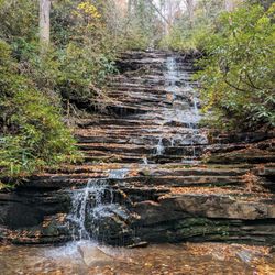
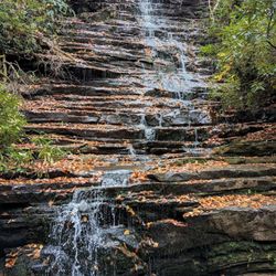
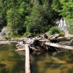
HEMLOCK FALLS TRAIL may very well be my new most favorite trail of all my hiking adventures. Normally the best part of any trail (at least for me) is the reward at the end. Sometimes it's a grand sweeping scenic vista with breathtaking views, but more often than not it is a gorgeous waterfall. However, my favorite part about visiting Hemolock Falls is the trail itself. ~~~ THE EXPERIENCE The trail follows Moccasin Creek closely for its entire length to the falls. The beauty of Moccasin Creek is that nearly all of it is fast flowing water, loaded with endless cascades and multiple waterfalls. You will see at least a dozen waterfalls before you even reach Hemolock Falls. This is due to the river dropping from 2800 feet elevation to 1868 feet elevation on its way to Lake Burton. That's over 932 feet in a 5 mile stretch. There are around 5 falls between 8-12 feet tall and many more that are only 5-8 feet tall, but gorgeous in their own right. My visit was after a 2-week period of rainfall that has saturated everything north of Atlanta in Georgia, so the water volume was excellent. Also, this sort of saturation spawns several other waterfalls that would likely be dry in a less rainy seasons. We found THREE large ribbon-like waterfalls at least 35-50' in height just off the trail looking into the woods. They were not on Moccasin Creek itself, but acted as tributaries [a river or stream flowing into a larger river or body of water]. There is even a small 5 foot waterfall directly on the trail. There are so many opportunities for fantastic photos and the best part is this is a very family friendly trail. Young and old alike can enjoy this trail without fear of your typical trail hazards. ~~~ UPPER MOCCASIN CREEK FALLS Unfortunately I was defeated trying to make it to this 2nd waterfall, which is a gorgeous 40' drop upstream of Hemlock Falls. According to some reports, you can follow an old mule trail to reach the upper falls, but may require some light bushwhacking! I made it to a thicket of impenetrable Rhododendrons and had to turn back. I was truly disgusted that I was defeated when I know I was so close! The falls are about a mile upstream from Hemlock, and I made it about 3/4 of a mile before turning back. NOTE - Several dangerous areas along the trail had me hovering above a 35 foot drop that would likely have been detrimental to my health if I slipped. Met some backpackers on my way back from this trail that told me of my mistake. I needed to cross the river about 300 yards up from Hemlock Falls to another trail left of the creek to continue towards the upper falls. They said the trail I took doesn't lead to a good viewing area of the upper falls. DANG IT!!! But like Arnold said in Terminator "I'LL BE BAUCK!" ~~~ [ THINGS TO KNOW ] Hiking Distance: 1.5 miles (roundtrip) according to State Park map Difficulty: Easy & family friendly (but can be muddy) Creek Crossings: YES (1) bridged Elevation Gain: 242 feet Waterfall Height: Approx 15 feet Access to top of falls: YES Access to base of falls: YES Pool of water @ base of Falls: YES Sitting areas @ base: YES RESTROOMS: NO PARKING: YES (12+ cars) ~~~ FINAL THOUGHTS Prior to this hike, Catawba Falls near Asheville has been my favorite trail. It is just as stunning as Hemlock Falls Trail and BONUS, the waterfall at the end is far bigger. Interestingly, they are both around the same length in distance, although the elevation gain is 60' greater to Catawba. Since Hemlock Falls is closer to home, I'm going to crown it my new fav. Enjoy! 2020 / 7

This is a wonderful hike for all ages. The Trail follows the river and is gorgeous all the way through. There's a decent size parking area at the start of the falls and it's close to the Moccasin Creek State Park. We thoroughly enjoyed this hike for its beauty, it's shade, and it wasn't too difficult. The falls themselves are absolutely beautiful. We only saw 2 other groups on our way out on the hike and maybe only 3 or 4 on the way out. The falls are excellent for viewing, photographing, having a picnic, or swimming at the base. This is a hike we will definitely come back to see and probably take a swim next time.

When I first read about Hemlock Falls, I got confused cause there is a Hemlock Falls at Cloudland Canyon State Park too. Coincidentally enough, Cloudland Canyon has two waterfalls - Hemlock & Cherokee. While Hemlock Falls where I just went has Hemlock & Ammons Falls. Although you do not need to go to Moccasin State Park to access Hemlock & Ammons Falls, it's close enough to it. Because the GPS took us straight to Hemlock Falls Trail without even seeing Moccasin State Park, we just went straight there. It's a narrow, muddy, lots of pot holes dirt role all the way to the parking area. It is a small parking area. Since it's not a parking lot with "lines," just an area for parking. Some people made their own space, just saying. There is a rock that has "Hemlock Falls Trail" so you cannot miss that. When you first start off, the walking trail is really wide, when you get closer to the falls, it will become more narrow. You will see lots of cascades on your right. It rained several days before so the path going to the main waterfall was really muddy. I think I missed Ammons Falls. I am not sure if they waterfalls where the bridge is Ammons Falls, it doesn't look like it from the photos? But some photos either has good angles, good camera, or just a great day. You known you hit Hemlock Falls when you know you cannot go any farther. It is a lot smaller than I would have thought. Plus you cannot go up and personal with the waterfall. There is a large body of water where it falls into, I wonder if it would be a swimming hole if allowed. I'm thinking Dicks Creek Falls. The trail itself is easy. There is not a lot of elevation changes nor a lot of tree roots. There were muddy areas that you have to be careful not to get wet but other than that, worth it for those who don't like long or difficult hikes. It's a good 2 miles round trip. 20/2018

My parents and I had the best time hiking the 2 mile round trip trail to the falls this morning! For a day where the high was 90 degrees, it was perfect! The entire trail is shaded under a beautiful tunnel of trees and it felt about 78 degrees during our hike which was perfect! The hike felt like a true hike in the blue ridge mountains of North Georgia without the steep and strenuous uphill rock climbing experience that comes with most hikes in the area. Very easy for my parents in their mid fifty's to do on a nice morning. There are lots of mini smaller waterfalls along the path so make sure you stop and take in the beauty of each little one you find before you keep moving. Don't confuse the little ones along the way for the Main falls at the end of the trail. You will know when you have reached it because the trail stops. As you walk along the trail you are beside the rushing river from the pool at the falls so you get to hike to the sounds of crisp mountain water rapids. I callus think of anything more soothing if I tried. The trail itself is very easy but there are lots of rocks, large roots, and some muddy shaded areas. So just be mindful while adventuring and watch your footing. Overall it was one of the more beautiful hikes in the Appalachian mountains I have done!

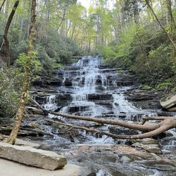
Hemlock is technically part of Moccasin Creek State park, although the park just so happens to be across the street from the park. The trail has parking right near the entrance of the access road and the access road is gravel. It's well worn gravel for the most part, but if you have a low sitting car, you may want to sit this one out. Once you get to the trail parking lot, the hiking trail to hemlock is about 1 mile one way. You hear the water before you see it, through all of the trees. Be sure to take advantage of any stringer trails to the right of the main trail, as these give you a good vantage point of the running water to your right. The trail itself narrows a bit the further in you go, but also opens quite a bit, revealing several good size cascades (mini falls), to your right. About 3/4 of the way along the trail, you'll cross a bridge, and the cascades and running water you saw on your right, shifts to your left. Some of these are fairly big! At some point you'll make your way to a clearing, a series of steps going down to that clearing, and a few large rocks you can sit on, right in front of the falls. The actual Hemlock falls aren't HUGE, but it's a nice waterfall that empties out into a small body of water below. I had the waterfall to myself for several minutes on a Saturday afternoon, so I don't know how busy it gets in general, although I did pass people coming and going along the way. There IS an upper Hemlock falls that requires taking the small trail to the right of Hemlock falls, and crossing it at the top before hiking another half mile or so until you find it. I did not do this, but there is that option. In terms of difficulty, Hemlock falls is not very difficult. It's 2 miles round trip, and the hiking is mostly flat and I saw children around 5 years old hiking it as well with their parents. Dog friendly also! Like I mentioned earlier, Hemlock falls is located literally right across the street from Moccasin creek state park, so if your GPS is giving you fits, just put in the address for Moccasin. I liked Hemlock falls for what it was, and while I wouldn't plan a day around it, if I were close, i'd definitely come back!

Decently maintained trail head with great views. A little over a mile to the waterfall. Good amount of parking at the trailhead. There are some large logs that you need to climb over near the falls and if it's rained recently at all the pathway can get slippery. Super worth the short hike!! The falls itself is stunning and you can swim up to it. Water is FREEZING but it's a fun dip! read more


3 months ago
The falls were just a mile from the trail head. We didn't venture further. It was a fun short out and back and scenic trail. Fun for the dogs. Fun for us to get a little wet too. This water feeds right into Burton Lake which is beautiful. I had planned to summit Double Spring Knob as my 16th 4ker in Georgia but Wildcat Road was closed for maintenance and it was another 7 mile hike from the closure, something I might have run, but today was a family weekend, and I think I made the right call. Double Knob will have to wait another day. read more


3 years ago
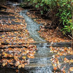
A beautiful but challenging walk to see several waterfalls. The trailhead for this is across from the Moccasin Creek Campground. There is a short drive down the gravel road to get to the walking trailhead. Do not forget to purchase a $5 parking pass from somewhere (online or at the Mocassin Creek Campground office). You can take the chance of not having a parking pass but I would not recommend it. I went there in the fall and the path was covered in leaves which is both beautiful and dangerous as the trail is covered in roots and rocks which the leaves cover very well. The walk to the lower falls is about 1.5 miles and to the upper falls is another 0.5 miles. I thought it was worth it for several reasons. There are more than just these two falls if you keep your eyes open along the path and the walk is very pretty. The walk can be very challenging as there are several places where you have to go over/under trees, the path is very narrow and slippery and the small bridge only has one railing and the entire path has lots of rocks and roots. It is an out-and-back trail. The upper falls are not large but are unique in their way with several rocks to sit on and enjoy the view and serenity. Overall, it was well worth the trip and I would recommend it to fellow travelers. read more


2 years ago
6 years ago
HEMLOCK FALLS TRAIL may very well be my new most favorite trail of all my hiking adventures. Normally the best part of any trail (at least for me) is the reward at the end. Sometimes it's a grand sweeping scenic vista with breathtaking views, but more often than not it is a gorgeous waterfall. However, my favorite part about visiting Hemolock Falls is the trail itself. ~~~ THE EXPERIENCE The trail follows Moccasin Creek closely for its entire length to the falls. The beauty of Moccasin Creek is that nearly all of it is fast flowing water, loaded with endless cascades and multiple waterfalls. You will see at least a dozen waterfalls before you even reach Hemolock Falls. This is due to the river dropping from 2800 feet elevation to 1868 feet elevation on its way to Lake Burton. That's over 932 feet in a 5 mile stretch. There are around 5 falls between 8-12 feet tall and many more that are only 5-8 feet tall, but gorgeous in their own right. My visit was after a 2-week period of rainfall that has saturated everything north of Atlanta in Georgia, so the water volume was excellent. Also, this sort of saturation spawns several other waterfalls that would likely be dry in a less rainy seasons. We found THREE large ribbon-like waterfalls at least 35-50' in height just off the trail looking into the woods. They were not on Moccasin Creek itself, but acted as tributaries [a river or stream flowing into a larger river or body of water]. There is even a small 5 foot waterfall directly on the trail. There are so many opportunities for fantastic photos and the best part is this is a very family friendly trail. Young and old alike can enjoy this trail without fear of your typical trail hazards. ~~~ UPPER MOCCASIN CREEK FALLS Unfortunately I was defeated trying to make it to this 2nd waterfall, which is a gorgeous 40' drop upstream of Hemlock Falls. According to some reports, you can follow an old mule trail to reach the upper falls, but may require some light bushwhacking! I made it to a thicket of impenetrable Rhododendrons and had to turn back. I was truly disgusted that I was defeated when I know I was so close! The falls are about a mile upstream from Hemlock, and I made it about 3/4 of a mile before turning back. NOTE - Several dangerous areas along the trail had me hovering above a 35 foot drop that would likely have been detrimental to my health if I slipped. Met some backpackers on my way back from this trail that told me of my mistake. I needed to cross the river about 300 yards up from Hemlock Falls to another trail left of the creek to continue towards the upper falls. They said the trail I took doesn't lead to a good viewing area of the upper falls. DANG IT!!! But like Arnold said in Terminator "I'LL BE BAUCK!" ~~~ [ THINGS TO KNOW ] Hiking Distance: 1.5 miles (roundtrip) according to State Park map Difficulty: Easy & family friendly (but can be muddy) Creek Crossings: YES (1) bridged Elevation Gain: 242 feet Waterfall Height: Approx 15 feet Access to top of falls: YES Access to base of falls: YES Pool of water @ base of Falls: YES Sitting areas @ base: YES RESTROOMS: NO PARKING: YES (12+ cars) ~~~ FINAL THOUGHTS Prior to this hike, Catawba Falls near Asheville has been my favorite trail. It is just as stunning as Hemlock Falls Trail and BONUS, the waterfall at the end is far bigger. Interestingly, they are both around the same length in distance, although the elevation gain is 60' greater to Catawba. Since Hemlock Falls is closer to home, I'm going to crown it my new fav. Enjoy! 2020 / 7 read more


This is a wonderful hike for all ages. The Trail follows the river and is gorgeous all the way through. There's a decent size parking area at the start of the falls and it's close to the Moccasin Creek State Park. We thoroughly enjoyed this hike for its beauty, it's shade, and it wasn't too difficult. The falls themselves are absolutely beautiful. We only saw 2 other groups on our way out on the hike and maybe only 3 or 4 on the way out. The falls are excellent for viewing, photographing, having a picnic, or swimming at the base. This is a hike we will definitely come back to see and probably take a swim next time. read more


When I first read about Hemlock Falls, I got confused cause there is a Hemlock Falls at Cloudland Canyon State Park too. Coincidentally enough, Cloudland Canyon has two waterfalls - Hemlock & Cherokee. While Hemlock Falls where I just went has Hemlock & Ammons Falls. Although you do not need to go to Moccasin State Park to access Hemlock & Ammons Falls, it's close enough to it. Because the GPS took us straight to Hemlock Falls Trail without even seeing Moccasin State Park, we just went straight there. It's a narrow, muddy, lots of pot holes dirt role all the way to the parking area. It is a small parking area. Since it's not a parking lot with "lines," just an area for parking. Some people made their own space, just saying. There is a rock that has "Hemlock Falls Trail" so you cannot miss that. When you first start off, the walking trail is really wide, when you get closer to the falls, it will become more narrow. You will see lots of cascades on your right. It rained several days before so the path going to the main waterfall was really muddy. I think I missed Ammons Falls. I am not sure if they waterfalls where the bridge is Ammons Falls, it doesn't look like it from the photos? But some photos either has good angles, good camera, or just a great day. You known you hit Hemlock Falls when you know you cannot go any farther. It is a lot smaller than I would have thought. Plus you cannot go up and personal with the waterfall. There is a large body of water where it falls into, I wonder if it would be a swimming hole if allowed. I'm thinking Dicks Creek Falls. The trail itself is easy. There is not a lot of elevation changes nor a lot of tree roots. There were muddy areas that you have to be careful not to get wet but other than that, worth it for those who don't like long or difficult hikes. It's a good 2 miles round trip. 20/2018 read more


My parents and I had the best time hiking the 2 mile round trip trail to the falls this morning! For a day where the high was 90 degrees, it was perfect! The entire trail is shaded under a beautiful tunnel of trees and it felt about 78 degrees during our hike which was perfect! The hike felt like a true hike in the blue ridge mountains of North Georgia without the steep and strenuous uphill rock climbing experience that comes with most hikes in the area. Very easy for my parents in their mid fifty's to do on a nice morning. There are lots of mini smaller waterfalls along the path so make sure you stop and take in the beauty of each little one you find before you keep moving. Don't confuse the little ones along the way for the Main falls at the end of the trail. You will know when you have reached it because the trail stops. As you walk along the trail you are beside the rushing river from the pool at the falls so you get to hike to the sounds of crisp mountain water rapids. I callus think of anything more soothing if I tried. The trail itself is very easy but there are lots of rocks, large roots, and some muddy shaded areas. So just be mindful while adventuring and watch your footing. Overall it was one of the more beautiful hikes in the Appalachian mountains I have done! read more


9 years ago
Hemlock is technically part of Moccasin Creek State park, although the park just so happens to be across the street from the park. The trail has parking right near the entrance of the access road and the access road is gravel. It's well worn gravel for the most part, but if you have a low sitting car, you may want to sit this one out. Once you get to the trail parking lot, the hiking trail to hemlock is about 1 mile one way. You hear the water before you see it, through all of the trees. Be sure to take advantage of any stringer trails to the right of the main trail, as these give you a good vantage point of the running water to your right. The trail itself narrows a bit the further in you go, but also opens quite a bit, revealing several good size cascades (mini falls), to your right. About 3/4 of the way along the trail, you'll cross a bridge, and the cascades and running water you saw on your right, shifts to your left. Some of these are fairly big! At some point you'll make your way to a clearing, a series of steps going down to that clearing, and a few large rocks you can sit on, right in front of the falls. The actual Hemlock falls aren't HUGE, but it's a nice waterfall that empties out into a small body of water below. I had the waterfall to myself for several minutes on a Saturday afternoon, so I don't know how busy it gets in general, although I did pass people coming and going along the way. There IS an upper Hemlock falls that requires taking the small trail to the right of Hemlock falls, and crossing it at the top before hiking another half mile or so until you find it. I did not do this, but there is that option. In terms of difficulty, Hemlock falls is not very difficult. It's 2 miles round trip, and the hiking is mostly flat and I saw children around 5 years old hiking it as well with their parents. Dog friendly also! Like I mentioned earlier, Hemlock falls is located literally right across the street from Moccasin creek state park, so if your GPS is giving you fits, just put in the address for Moccasin. I liked Hemlock falls for what it was, and while I wouldn't plan a day around it, if I were close, i'd definitely come back! read more


 - Hiking Near Me - Clarkesville, Georgia")


4 years ago
9 years ago
16 years ago
A scenic out and back hike along Moccasin Creek that is not very strenuous, but very pretty. You cross the creek on a wooden bridge about midway and hike up to the falls. Great place to bring all ages. It's slightly uphill most of the way out, which makes for a slightly downhill return to the parking lot. It's about 1 mile out and 1 mile back. read more


10 years ago
More info about Hemlock Falls Trail
Andersonville Ln
Clarkesville, GA 30523
Directions
Visit Website
http://www.secretfalls.com
Hours
Outdoor Amenities
Ask the Community - Hemlock Falls Trail
Review Highlights - Hemlock Falls Trail


Why does Yelp recommend reviews?
1 review that is not currently recommended
The reviews below are not factored into the business's overall star rating.
5 years ago
Hemlock Falls Trail - hiking - Updated June 2026
Best of Clarkesville
People found Hemlock Falls Trail by searching for…
Hiking Trails With Waterfalls in Clarkesville, Georgia
Swimming Holes in Clarkesville, Georgia
Rock Climbing in Clarkesville, Georgia
Things to Do in Clarkesville, Georgia
Off Road Trails in Clarkesville, Georgia
Parks in Clarkesville, Georgia
Scenic Drive in Clarkesville, Georgia
Campgrounds in Clarkesville, Georgia
Scenic Overlook in Clarkesville, Georgia
Scenic View in Clarkesville, Georgia
River Swimming in Clarkesville, Georgia
Photo Spots in Clarkesville, Georgia
Picnic Areas in Clarkesville, Georgia
Walking Trails in Clarkesville, Georgia
Hiking With Kids in Clarkesville, Georgia
Canyoneering in Clarkesville, Georgia
Waterfalls in Clarkesville, Georgia
Easy Hikes in Clarkesville, Georgia
Dog Friendly Trails in Clarkesville, Georgia
Hikes With Dogs in Clarkesville, Georgia
Lookout Points in Clarkesville, Georgia
Swimming in Clarkesville, Georgia
Trending Searches in Clarkesville, GA
Black Owned Nail Salons near Hemlock Falls Trail
Boat Rental near Hemlock Falls Trail
Cliff Jumping near Hemlock Falls Trail
Day Trips near Hemlock Falls Trail
Dog Friendly Trails near Hemlock Falls Trail
Fishing Spots near Hemlock Falls Trail
Jet Ski Rental near Hemlock Falls Trail
Kayak Rental near Hemlock Falls Trail
Lakes & Ponds near Hemlock Falls Trail
Off Road Trails near Hemlock Falls Trail
Outdoor Activities near Hemlock Falls Trail
Public Pools near Hemlock Falls Trail
Public Shower near Hemlock Falls Trail
River Swimming near Hemlock Falls Trail
Rock Quarry near Hemlock Falls Trail
Scenic Overlook near Hemlock Falls Trail
Secluded Spots near Hemlock Falls Trail
Soccer Store near Hemlock Falls Trail
Splash Pad near Hemlock Falls Trail
Strawberry Picking near Hemlock Falls Trail
Swimming Holes near Hemlock Falls Trail
Swimming Lakes near Hemlock Falls Trail
U Pick Farms near Hemlock Falls Trail
Watch Sunset near Hemlock Falls Trail
Browse Articles
Browse Nearby
Browse Brands
Related Searches in Clarkesville, GA
Affordable Kayak Rental Services in Clarkesville, Georgia
Best Fishing Locations and Guides in Clarkesville, Georgia
Best Places for Horseback Riding in Clarkesville, Georgia
Best Waterfalls and Swimming Holes in Clarkesville, Georgia
Check Out Off Road Trails in Clarkesville, Georgia
Discover Dog Friendly Trails to Explore in Clarkesville, Georgia
Discover a Hiking Trail in Clarkesville, Georgia
Discover the Best Night Hike Trails in Clarkesville, Georgia
Discover the Best Running Track in Clarkesville, Georgia
Enjoy Exciting Mountain Biking Adventures in Clarkesville, Georgia
Enjoy Tent Camping Spots Around Clarkesville, Georgia
Enjoy the Best Tubing Experiences in Clarkesville, Georgia
Enjoy the Best Walking Trails in Clarkesville, Georgia
Exciting Cliff Jumping Spots in Clarkesville, Georgia
Experience Thrilling White Water Rafting in Clarkesville, Georgia
Explore Beautiful Parks and Green Spaces in Clarkesville, Georgia
Explore Bike Rentals Throughout Clarkesville, Georgia
Explore Easy Hikes Perfect for All in Clarkesville, Georgia
Explore Fun Activities to Do in Clarkesville, Georgia
Explore Popular Campgrounds Near Clarkesville, Georgia
Explore Popular RV Parks Around Clarkesville, Georgia
Explore Popular Scenic Overlook Points in Clarkesville, Georgia
Explore Scenic Lakes to Visit in Clarkesville, Georgia
Explore Top Dog Parks in Clarkesville, Georgia Near You
Explore Top Water Parks in Clarkesville, Georgia Today
Explore the Best Boating Spots in Clarkesville, Georgia
Explore the Best Swimming Holes Around Clarkesville, Georgia
Find Beautiful Views in Clarkesville, Georgia
Find Cozy Camping Cabins in Clarkesville, Georgia
Find Parks and Recreation Activities in Clarkesville, Georgia
Find Popular Ziplining Spots Around Clarkesville, Georgia
Find the Best Playgrounds to Visit in Clarkesville, Georgia
Find the Best Scenic View Locations in Clarkesville, Georgia
Hiking Trails With Waterfalls in Clarkesville, Georgia
Off Leash Dog Hiking Trails in Clarkesville, Georgia
Plan a Scenic Drive Route Near Clarkesville, Georgia
Popular Fishing Spots to Explore in Clarkesville, Georgia
Popular Kids Activities in Clarkesville, Georgia
Popular Outdoor Activities to Try in Clarkesville, Georgia
Popular Picnic Spots to Visit in Clarkesville, Georgia
Popular Things to Do in Clarkesville, Georgia
Safe River Swimming Areas in Clarkesville, Georgia
Safe and Fun Parks for Kids in Clarkesville, Georgia
Top Climbing Spots and Gyms in Clarkesville, Georgia
Top Paddleboarding Activities in Clarkesville, Georgia
Top Running Trails to Explore in Clarkesville, Georgia
Top Swimming Lakes to Enjoy in Clarkesville, Georgia
Top Swimming Spots and Pools in Clarkesville, Georgia