Moccasin Creek State Park Photos


More like Moccasin Creek State Park
Recommended Reviews - Moccasin Creek State Park
Start your review...

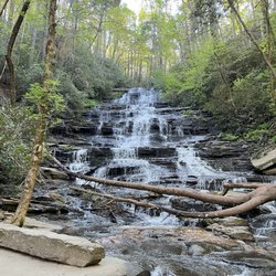
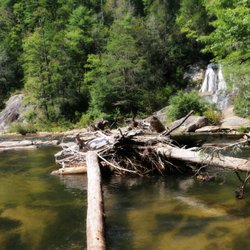
This is a great state park if you want to be right on the water. Lake Rabun is a pretty lake with plenty to do if you have a boat or kayak. The camping area is compact and has a lot of kids on bikes, people walking around, and lots of boat/fishing action. The bathhouse seemed to be well maintained and clean. Don't miss Hemlock Falls across the street as it's a gorgeous hike with a beautiful falls. This is all we saw of the park this time, but hope to be back to explore more and to get on the water. read more


3 years ago
9 years ago
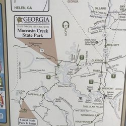
Labeled as the smallest Georgia state park by staff I spoke to today, Moccasin Creek State Park isn't a park you want to go to if you're dying for a great variety of hikes. In fact, front their front gate, you can pretty much see everything there is to see at Moccasin. Seemingly a state park for escape, Moccasin Creek State park is a camper's delight, as the great majority of the park's central real estate is taken up by camp/rv spots. Just past the camper spots is a VERY nice lake with benches and swings littering the edges of the lake for casual watching, relaxing, fishing, you name it. Want to get on the water? You can bring your boat, and there are parking areas specific for boat trailers and vehicles pulling them. Want to get on the water but don't have a boat? Moccasin rents out kayaks. Want to fish? You need a permit...sorry. I did mention that Moccasin isn't the park to go to if you're looking for a hike. That's only partially true. The popular Hemlock falls trail is a part of the park....loosely...and is directly across the street. I'll have a review of it up shortly that you can check out. In addition to all that I mentioned, there's a basketball hoop, volley ball net, an assembly shelter/pavilion, showers for registered campers only, and i'm sure there's plenty of thn=ings that i'm missing. What i'm trying to say is they have a lot of activities you can do if you want to spend a weekend chilling at the lake. Located off of Highway 197 in Clarksville, GA, Moccasin Creek state park is only 30 minutes or so away from parks such as Black Rock Mountain and Tallulah Gorge for your reference, and it's not too terribly far from a major interstate.and civilization Moccasin Creek State Park is a little slow for my speed, but it's a great park, and if you're the type who wants to lounge by a fire, chit chat and do so with a lake back drop, you really should give them a try. read more


7 years ago
This is a very small state park. If your spot is on the outer circles you are in luck. In the middle spots you will be on top of others. Nice hiking across the street. Plenty of fishing on the lake. Not much else to do in the area without driving into Clayton. It is clean and well kept. read more
4 years ago
5 years ago
9 years ago
9 years ago
More info about Moccasin Creek State Park
3655 Highway 197
Clarkesville, GA 30523
Directions
(706) 947-0150
Call Now
Hours
Outdoor Amenities
Ask the Community - Moccasin Creek State Park


Moccasin Creek State Park - parks - Updated May 2026
Best of Clarkesville
People found Moccasin Creek State Park by searching for…
Fishing in Clarkesville, Georgia
Campgrounds in Clarkesville, Georgia
Lakes in Clarkesville, Georgia
Water Parks in Clarkesville, Georgia
Things to Do in Clarkesville, Georgia
Playgrounds in Clarkesville, Georgia
Hiking Trails in Clarkesville, Georgia
Volleyball Courts in Clarkesville, Georgia
Fishing Spots in Clarkesville, Georgia
Basketball Courts in Clarkesville, Georgia
Indoor Playgrounds for Kids in Clarkesville, Georgia
Scenic Drive in Clarkesville, Georgia
Waterfall Hike in Clarkesville, Georgia
Fishing With Kids in Clarkesville, Georgia
Fishing Lake in Clarkesville, Georgia
Dog Swimming in Clarkesville, Georgia
Places to Take Pictures in Clarkesville, Georgia
State Parks Camping in Clarkesville, Georgia
Hiking With Kids in Clarkesville, Georgia
Picnic Areas in Clarkesville, Georgia
Lakes & Ponds in Clarkesville, Georgia
Parks BBQ Grills in Clarkesville, Georgia
Trending Searches in Clarkesville, GA
Baseball Fields near Moccasin Creek State Park
Boat Rental near Moccasin Creek State Park
Botanical Gardens near Moccasin Creek State Park
Bounce House Rentals near Moccasin Creek State Park
Campgrounds near Moccasin Creek State Park
Cliff Jumping near Moccasin Creek State Park
Flower Shop near Moccasin Creek State Park
Free Picnic Areas near Moccasin Creek State Park
Garage Sales near Moccasin Creek State Park
Garden Center near Moccasin Creek State Park
Hair near Moccasin Creek State Park
Nurseries & Gardening near Moccasin Creek State Park
Outdoor Activities near Moccasin Creek State Park
Outdoor Furniture Stores near Moccasin Creek State Park
Party Equipment Rentals near Moccasin Creek State Park
Pedicure near Moccasin Creek State Park
Pick Your Own Farms near Moccasin Creek State Park
Picnic Spots near Moccasin Creek State Park
Places To Take Pictures near Moccasin Creek State Park
Plant Nursery near Moccasin Creek State Park
Rock Quarry near Moccasin Creek State Park
Scenic Drive near Moccasin Creek State Park
Splash Pad near Moccasin Creek State Park
Browse Articles
Browse Nearby
Browse Brands
Related Searches in Clarkesville, GA
Best Parks for Parties and Events in Clarkesville, Georgia
Best Water Parks for Kids in Clarkesville, Georgia
Check Out Great Playgrounds in Clarkesville, Georgia
Discover Baseball Fields Around Clarkesville, Georgia
Discover Fun Activities to Do in Clarkesville, Georgia
Discover Fun Toddler Parks in Clarkesville, Georgia for Your Little One
Discover Popular Photo Spots in Clarkesville, Georgia
Discover Soccer Fields in Clarkesville, Georgia Near You
Discover Top Nature Parks to Visit in Clarkesville, Georgia
Discover the Best Beaches in Clarkesville, Georgia
Enjoy the Best Picnic Spots and Ideas in Clarkesville, Georgia
Enjoy the Best Walking Trails in Clarkesville, Georgia
Explore Beautiful Botanical Gardens in Clarkesville, Georgia
Explore Family-Friendly Zoos and Wildlife in Clarkesville, Georgia
Explore Free Picnic Areas Around Clarkesville, Georgia
Explore Fun Activities to Do in Clarkesville, Georgia
Explore Parks With Pull Up Bars in Clarkesville, Georgia
Explore Popular Campgrounds Near Clarkesville, Georgia
Explore Popular Picnic Areas Around Clarkesville, Georgia
Explore Popular RV Parks Around Clarkesville, Georgia
Explore Popular Recreation Centers Around Clarkesville, Georgia
Explore Popular Scenic Views Near Clarkesville, Georgia
Explore Scenic Lakes to Visit in Clarkesville, Georgia
Explore Top Dog Parks in Clarkesville, Georgia Near You
Explore Top Gyms in Clarkesville, Georgia Now
Explore Top Water Parks in Clarkesville, Georgia Today
Explore the Best Swimming Holes Around Clarkesville, Georgia
Find Parks and Recreation Activities in Clarkesville, Georgia
Find Top Dog Friendly Parks to Visit in Clarkesville, Georgia
Find Top Skate Parks in Clarkesville, Georgia for All Skill Levels
Find Top Skating Rinks in Clarkesville, Georgia for All Ages
Find Top-Rated Waterfalls in Clarkesville, Georgia Now
Find a Park With BBQ Pits in Clarkesville, Georgia
Find the Best Parks BBQ Grills in Clarkesville, Georgia
Find the Best Parks for Picnics in Clarkesville, Georgia
Find the Best Swimming Pools in Clarkesville, Georgia Today
Have Fun at a Splash Pad in Clarkesville, Georgia
Must-See Tourist Attractions Around Clarkesville, Georgia
Parks With Basketball Courts for Games in Clarkesville, Georgia
Picnic Areas With BBQ Pits Available in Clarkesville, Georgia
Popular Fishing Spots to Explore in Clarkesville, Georgia
Popular Kids Activities in Clarkesville, Georgia
Popular Outdoor Activities to Try in Clarkesville, Georgia
Popular Places to Take Pictures in Clarkesville, Georgia
Top Hiking Trails to Explore in Clarkesville, Georgia
Top Running Trails to Explore in Clarkesville, Georgia
Top Swimming Lakes to Enjoy in Clarkesville, Georgia
Top Swimming Spots and Pools in Clarkesville, Georgia
Top-Rated Basketball Courts to Play at in Clarkesville, Georgia
People who viewed Moccasin Creek State Park also viewed
Unicoi State Park
78 reviews
$$
Meeks Park
25 reviews
Towns County Beach & Playground
6 reviews
Anna Ruby Falls
202 reviews
Dukes Creek Falls Trail
50 reviews
Dicks Creek Falls
12 reviews
Helton Creek Falls
42 reviews
Upper Moccasin Creek Falls
2 reviews
Reedy Branch Falls Trailhead
4 reviews
Blood Mountain Wilderness Area
25 reviews