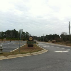
Yahoola Creek Park Photos


You might also consider
More like Yahoola Creek Park
Recommended Reviews - Yahoola Creek Park
Start your review...

Reviews With Photos

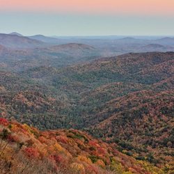
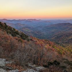
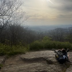
This is a beautiful park and a very challenging hike up. We spotted a good bit of different species of insects and birds. There are awesome sceneries of creeks and streams if you look hard enough. We got a good sweat with the red trail and it really got our hearts pumping, definitely lost a few pounds.

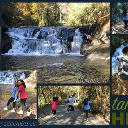
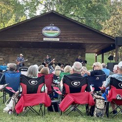
Living here in Dahlonega for the past few years I have come to really appreciate this park especially when you have a little one. The park contains tennis courts, soccer fields and baseball fields. There are bathrooms near both playgrounds. Next to one playground is the new splash pad that they just opened up for Summer '19! There are stairs that go down to the river and from there you can lay out towels and go swimming. It's definitely a big summer spot now that the community pool is gone. There is also a pavilion that you can rent for parties or events on the other side of the park near the older playground. Hiking trails are also inside the park and there is usually an event that goes on every year with those trails too. Dogs are allowed and they have little stations throughout the park for the dog poo. Will miss this park when we are gone! The only thing I don't like about it is that during the summer the splash pad can get very crowded during the day and some of the "fountains" inside of it already need to be fixed from all the kids stepping all over everything.

2 years ago
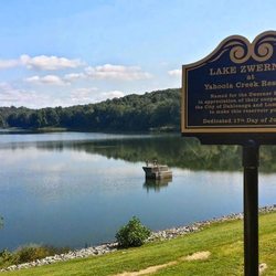
Wonderful park with a creek running alongside. It has a splash pad, picnic table and ample amount of different spaces where kids and adults alike can enjoy. Our kids had a wonderful time. As a family you will have wonderful time. Don't forget your picnic food and mat. read more


5 years ago
Great park with lots of trails and paths, some with hills... Disc Golf Course... Organized sports... read more
4 years ago
This is a great park. We came here twice on our visit to Dahlonega. We hiked the trails and my boys played in the creek. They have a splash pad and 2 different playgrounds, and you can swim in the creek! read more
6 years ago
This is a beautiful park and a very challenging hike up. We spotted a good bit of different species of insects and birds. There are awesome sceneries of creeks and streams if you look hard enough. We got a good sweat with the red trail and it really got our hearts pumping, definitely lost a few pounds. read more


4 years ago
6 years ago
7 years ago
Living here in Dahlonega for the past few years I have come to really appreciate this park especially when you have a little one. The park contains tennis courts, soccer fields and baseball fields. There are bathrooms near both playgrounds. Next to one playground is the new splash pad that they just opened up for Summer '19! There are stairs that go down to the river and from there you can lay out towels and go swimming. It's definitely a big summer spot now that the community pool is gone. There is also a pavilion that you can rent for parties or events on the other side of the park near the older playground. Hiking trails are also inside the park and there is usually an event that goes on every year with those trails too. Dogs are allowed and they have little stations throughout the park for the dog poo. Will miss this park when we are gone! The only thing I don't like about it is that during the summer the splash pad can get very crowded during the day and some of the "fountains" inside of it already need to be fixed from all the kids stepping all over everything. read more


5 years ago
10 years ago
Excellent park! Love the trails, love the caves, and love love LOVE the swings! Only complaint is that they break pretty often. But it's still a great park! Best park I've ever been to. read more
8 years ago
More info about Yahoola Creek Park
464 Mechanicsville Rd
Dahlonega, GA 30533
Directions
Hours
Indoor Amenities
Outdoor Amenities
Ask the Community - Yahoola Creek Park
Review Highlights - Yahoola Creek Park


Why does Yelp recommend reviews?
1 review that is not currently recommended
The reviews below are not factored into the business's overall star rating.
7 years ago
Yahoola Creek Park - parks - Updated May 2026
Best of Dahlonega
People found Yahoola Creek Park by searching for…
Trending Searches in Dahlonega, GA
Baseball Fields near Yahoola Creek Park
Botanical Gardens near Yahoola Creek Park
Bounce House Rentals near Yahoola Creek Park
Campgrounds near Yahoola Creek Park
Cheap Plants near Yahoola Creek Park
Cherry Picking near Yahoola Creek Park
Cliff Jumping near Yahoola Creek Park
Creeks near Yahoola Creek Park
Fishing Ponds near Yahoola Creek Park
Flower Shop near Yahoola Creek Park
Garage Sales near Yahoola Creek Park
Garden Center near Yahoola Creek Park
Nurseries & Gardening near Yahoola Creek Park
Off Leash Dog Parks near Yahoola Creek Park
Outdoor Activities near Yahoola Creek Park
Outdoor Furniture Stores near Yahoola Creek Park
Party Equipment Rentals near Yahoola Creek Park
Pedicure near Yahoola Creek Park
Photo Spots near Yahoola Creek Park
Picnic Areas near Yahoola Creek Park
Places To Take Pictures For Prom near Yahoola Creek Park
Public Beaches near Yahoola Creek Park
Public Running Track near Yahoola Creek Park
Rock Quarry near Yahoola Creek Park
Rv Rental near Yahoola Creek Park
Spray Tanning near Yahoola Creek Park
Swimming Holes near Yahoola Creek Park
Browse Articles
Browse Nearby
Browse Brands
Related Searches in Dahlonega, GA
Best Nature Trails for Hiking in Dahlonega, Georgia
Best Off Leash Dog Parks in Dahlonega, Georgia
Best Parks for Parties and Events in Dahlonega, Georgia
Best Water Parks for Kids in Dahlonega, Georgia
Check Out Great Playgrounds in Dahlonega, Georgia
Discover Baseball Fields Around Dahlonega, Georgia
Discover Fun Toddler Parks in Dahlonega, Georgia for Your Little One
Discover Lakes & Ponds to Explore in Dahlonega, Georgia
Discover Popular Photo Spots in Dahlonega, Georgia
Discover Soccer Fields in Dahlonega, Georgia Near You
Discover Top Nature Parks to Visit in Dahlonega, Georgia
Discover Top State Parks to Visit in Dahlonega, Georgia
Discover the Best Beaches in Dahlonega, Georgia
Enjoy the Best Family Activities in Dahlonega, Georgia
Enjoy the Best Picnic Spots and Ideas in Dahlonega, Georgia
Enjoy the Best Walking Trails in Dahlonega, Georgia
Explore Beautiful Botanical Gardens in Dahlonega, Georgia
Explore Easy Hikes Perfect for All in Dahlonega, Georgia
Explore Family-Friendly Zoos and Wildlife in Dahlonega, Georgia
Explore Free Picnic Areas Around Dahlonega, Georgia
Explore Fun Activities to Do in Dahlonega, Georgia
Explore Parks With Pull Up Bars in Dahlonega, Georgia
Explore Pickleball Courts in Dahlonega, Georgia
Explore Popular Campgrounds Near Dahlonega, Georgia
Explore Popular Picnic Areas Around Dahlonega, Georgia
Explore Popular RV Parks Around Dahlonega, Georgia
Explore Popular Recreation Centers Around Dahlonega, Georgia
Explore Popular Scenic Views Near Dahlonega, Georgia
Explore Scenic Lakes to Visit in Dahlonega, Georgia
Explore Top Dog Parks in Dahlonega, Georgia Near You
Explore Top Water Parks in Dahlonega, Georgia Today
Explore the Best Swimming Holes Around Dahlonega, Georgia
Find Parks and Recreation Activities in Dahlonega, Georgia
Find Top Dog Friendly Parks to Visit in Dahlonega, Georgia
Find Top Skate Parks in Dahlonega, Georgia for All Skill Levels
Find a Park With BBQ Pits in Dahlonega, Georgia
Find the Best Parks BBQ Grills in Dahlonega, Georgia
Fun Things for Kids in Dahlonega, Georgia
Have Fun at a Splash Pad in Dahlonega, Georgia
Locate Tennis Courts Around Dahlonega, Georgia
Parks With Basketball Courts for Games in Dahlonega, Georgia
Picnic Areas With BBQ Pits Available in Dahlonega, Georgia
Popular Fishing Spots to Explore in Dahlonega, Georgia
Popular Outdoor Activities to Try in Dahlonega, Georgia
Top Hiking Trails to Explore in Dahlonega, Georgia
Top Running Trails to Explore in Dahlonega, Georgia
Top Swimming Lakes to Enjoy in Dahlonega, Georgia
Top-Rated Basketball Courts to Play at in Dahlonega, Georgia