Springer Mountain Photos


More like Springer Mountain
Recommended Reviews - Springer Mountain
Start your review...

2 months ago
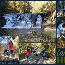
To get to the parking area for this is a 40 min dirt road drive on beautiful red earth and cliffs on the side of you going up. The views are beautiful but the drive is something haha. The hike itself is straight forward and beautiful. The makeup of the rocks causes them to appear like they glitter on the trail which was magic to my kids. There is a lean to on the trail they don't suggest using due to erosion. There are two nice metal markers in the rock to denote the official start of the Appalachian trail and what a glorious view you can sit and enjoy the beginning of your life changing journey! read more


5 years ago
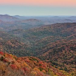
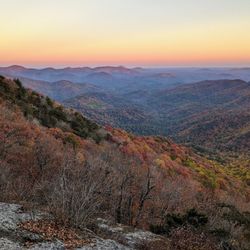
Beautiful views and a wonderful trail to the summit!:) Not a difficult hike- family/kid friendly. I would recommend hiking the trail earlier in the morning- seems like it gets busy later in the day.... read more


8 years ago
19 years ago
More info about Springer Mountain


Why does Yelp recommend reviews?
Springer Mountain - parks - Updated July 2026
Best of Dahlonega
People found Springer Mountain by searching for…
Scenic Overlook in Dahlonega, Georgia
Things to Do in Dahlonega, Georgia
Hiking Trails in Dahlonega, Georgia
Places to Take Pictures in Dahlonega, Georgia
Easy Hikes in Dahlonega, Georgia
Playgrounds in Dahlonega, Georgia
Scenic View in Dahlonega, Georgia
Walking Trails in Dahlonega, Georgia
River Swimming in Dahlonega, Georgia
Beautiful Views in Dahlonega, Georgia
Off Road Trails in Dahlonega, Georgia
Dog Friendly Trails in Dahlonega, Georgia
Waterfalls in Dahlonega, Georgia
Hiking With Kids in Dahlonega, Georgia
Public Running Track in Dahlonega, Georgia
Fun Things to Do at Night in Dahlonega, Georgia
Public Shower in Dahlonega, Georgia
Waterfall Hike in Dahlonega, Georgia
Things to Do on a Rainy Day in Dahlonega, Georgia
Secret Spots in Dahlonega, Georgia
Scenic Drive in Dahlonega, Georgia
Tent Camping in Dahlonega, Georgia
Trending Searches in Dahlonega, GA
4th Of July Fireworks near Springer Mountain
Baseball Fields near Springer Mountain
Black Owned Nail Salons near Springer Mountain
Boat Rental near Springer Mountain
Cliff Jumping near Springer Mountain
Day Trips near Springer Mountain
Dog Friendly Beaches near Springer Mountain
Dog Friendly Trails near Springer Mountain
Fireworks near Springer Mountain
Fishing Spots near Springer Mountain
Jet Ski Rental near Springer Mountain
Kayak Rental near Springer Mountain
Lakes & Ponds near Springer Mountain
Outdoor Activities near Springer Mountain
Places To Walk Around near Springer Mountain
Public Beaches near Springer Mountain
Public Pools near Springer Mountain
Public Shower near Springer Mountain
River Swimming near Springer Mountain
Rock Quarry near Springer Mountain
Scenic Night View near Springer Mountain
Scenic Overlook near Springer Mountain
Secluded Spots near Springer Mountain
Soccer Store near Springer Mountain
Splash Pad near Springer Mountain
Strawberry Picking near Springer Mountain
Swimming Holes near Springer Mountain
Swimming Lakes near Springer Mountain
Things To Do With Kids near Springer Mountain
View Fireworks near Springer Mountain
Watch Sunset near Springer Mountain
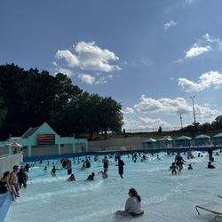
Water Parks near Springer Mountain
Browse Brands
Related Searches in Dahlonega, GA
Affordable Kayak Rental Services in Dahlonega, Georgia
Best Fishing Locations and Guides in Dahlonega, Georgia
Best Nature Trails for Hiking in Dahlonega, Georgia
Best Off Leash Dog Parks in Dahlonega, Georgia
Best Parks for Parties and Events in Dahlonega, Georgia
Best Places for Horseback Riding in Dahlonega, Georgia
Best Water Parks for Kids in Dahlonega, Georgia
Best Waterfalls and Swimming Holes in Dahlonega, Georgia
Check Out Great Playgrounds in Dahlonega, Georgia
Check Out Off Road Trails in Dahlonega, Georgia
Discover Baseball Fields Around Dahlonega, Georgia
Discover Dog Friendly Trails to Explore in Dahlonega, Georgia
Discover Fun Toddler Parks in Dahlonega, Georgia for Your Little One
Discover Kid Friendly Hiking Trails in Dahlonega, Georgia
Discover Lakes & Ponds to Explore in Dahlonega, Georgia
Discover Popular Photo Spots in Dahlonega, Georgia
Discover Scenic Mountain Bike Trails Near Dahlonega, Georgia
Discover Scenic Waterfall Spots in Dahlonega, Georgia
Discover Soccer Fields in Dahlonega, Georgia Near You
Discover Top Nature Parks to Visit in Dahlonega, Georgia
Discover Top State Parks to Visit in Dahlonega, Georgia
Discover a Hiking Trail in Dahlonega, Georgia
Discover the Best Beaches in Dahlonega, Georgia
Discover the Best Night Hike Trails in Dahlonega, Georgia
Discover the Best Running Track in Dahlonega, Georgia
Dog-Friendly Hikes With Dogs in Dahlonega, Georgia
Enjoy Exciting Mountain Biking Adventures in Dahlonega, Georgia
Enjoy Kayaking Adventures in Dahlonega, Georgia
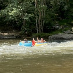
Enjoy River Tubing Adventures in Dahlonega, Georgia
Enjoy Tent Camping Spots Around Dahlonega, Georgia
Enjoy a Beautiful Waterfall Hike in Dahlonega, Georgia
Enjoy the Best Family Activities in Dahlonega, Georgia
Enjoy the Best Picnic Spots and Ideas in Dahlonega, Georgia
Enjoy the Best Tubing Experiences in Dahlonega, Georgia
Enjoy the Best Walking Trails in Dahlonega, Georgia
Exciting Cliff Jumping Spots in Dahlonega, Georgia
Experience Thrilling White Water Rafting in Dahlonega, Georgia
Explore Beautiful Botanical Gardens in Dahlonega, Georgia
Explore Beautiful Parks and Green Spaces in Dahlonega, Georgia
Explore Easy Hikes Perfect for All in Dahlonega, Georgia
Explore Family-Friendly Zoos and Wildlife in Dahlonega, Georgia
Explore Free Picnic Areas Around Dahlonega, Georgia
Explore Fun Activities to Do in Dahlonega, Georgia
Explore Parks With Pull Up Bars in Dahlonega, Georgia
Explore Pickleball Courts in Dahlonega, Georgia
Explore Popular Campgrounds Near Dahlonega, Georgia
Explore Popular Picnic Areas Around Dahlonega, Georgia
Explore Popular RV Parks Around Dahlonega, Georgia
Explore Popular Recreation Centers Around Dahlonega, Georgia
Explore Popular Scenic Overlook Points in Dahlonega, Georgia