Moccasin Creek State Park Photos


More like Moccasin Creek State Park
Recommended Reviews - Moccasin Creek State Park
Start your review...

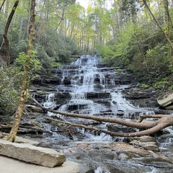
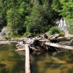
My son and I went tent camping in Aug before his school started. Didn't realize how busy this place was, but did manage to get one of the last two spots one week prior. The place met all our expectations, however one thing I didn't think about was how close the main road is to the campsites. So, being in a tent, you can easily hear all the traffic. The place seems to be more suited to RV campers since it's so close to the main road. But, at least the restrooms were never busy. The location is convenient to Hemlock Falls, but be aware walking there involves a trek just to get to the parking lot at Hemlock Falls. We opted to drive there, even though it's just across the street. We got spotty cell coverage at the campsite and could sometimes get one bar of signal. Though there is wifi at the office, its range is limited and is slow. Park is kept clean and restrooms are acceptable. The office maintains a stock of various supplies and prices are reasonable. Park is relatively small, but there are a number of things to do: playground, volleyball, basketball, horseshoes, kayak, canoe, paddle board, and fishing. Swimming is not really allowed. Highlight of our trip was laying on the dock at midnight and watching the shooting stars in the clear night. read more


2 years ago
A very nice place to stop This was along the route as we drove through the mountains looking for the change of leaves and the best place to view them. The road (SR 197) travels across or along several fingers of Lake Burton on its route to the mountains to connect up with I-76 on the north end. This campground is along the east side of the road and across from the Hemlock Falls trailhead entrance. It is situated along the lake with a beautiful view. The office is right up front on the right as you drive into the grounds. The staff were very friendly and helpful. The office is not very big. The park advertises that it sits on 32 Acres and has 53 tent, trailer & RV campsites, a boat Dock and ramp, a wildlife observation tower, a fishing Pier -- ADA accessible, and a playground. The office is a good place to check in for the campgrounds or to get a parking pass for seeing the falls. The grounds were well maintained and there was a large open-air pavilion situated right along the lake. Overall, it is s nice place to stop, seems a nice place to camp, and is convenient for those seeking to hike to Hemlock Falls. read more

More info about Moccasin Creek State Park
Ask the Community - Moccasin Creek State Park


Moccasin Creek State Park - parks - Updated May 2026
Best of Clarkesville
People found Moccasin Creek State Park by searching for…
Things to Do in Clarkesville, GA
Campgrounds in Clarkesville, GA
Watch Sunset in Clarkesville, GA
Playgrounds in Clarkesville, GA
Star Gazing in Clarkesville, GA
Volleyball Courts in Clarkesville, GA
Places to Swim in Clarkesville, GA
Places to Take Pictures in Clarkesville, GA
Sunset View in Clarkesville, GA
River Swimming in Clarkesville, GA
Fishing Lake in Clarkesville, GA
Swimming Lakes in Clarkesville, GA
Basketball Courts in Clarkesville, GA
Fishing Spots in Clarkesville, GA
Hiking Trails With Waterfalls in Clarkesville, GA
Running Track in Clarkesville, GA
Scenic Overlook in Clarkesville, GA
Secret Spots in Clarkesville, GA
Parks for Kids in Clarkesville, GA
Trending Searches in Clarkesville, GA
Baseball Fields near Moccasin Creek State Park
Boat Rental near Moccasin Creek State Park
Botanical Gardens near Moccasin Creek State Park
Bounce House Rentals near Moccasin Creek State Park
Campgrounds near Moccasin Creek State Park
Cliff Jumping near Moccasin Creek State Park
Fishing Spots near Moccasin Creek State Park
Flower Shop near Moccasin Creek State Park
Garage Sales near Moccasin Creek State Park
Garden Center near Moccasin Creek State Park
Hair near Moccasin Creek State Park
Nurseries & Gardening near Moccasin Creek State Park
Outdoor Activities near Moccasin Creek State Park
Outdoor Furniture Stores near Moccasin Creek State Park
Party Equipment Rentals near Moccasin Creek State Park
Pedicure near Moccasin Creek State Park
Pick Your Own Farms near Moccasin Creek State Park
Picnic Areas near Moccasin Creek State Park
Places To Take Pictures near Moccasin Creek State Park
Public Running Track near Moccasin Creek State Park
Rock Quarry near Moccasin Creek State Park
Rv Rental near Moccasin Creek State Park
Scenic Drive near Moccasin Creek State Park
Splash Pad near Moccasin Creek State Park
Swimming Holes near Moccasin Creek State Park
Browse Articles
Browse Nearby
BEST of Clarkesville, Georgia Picnic Areas near Moccasin Creek State Park
BEST of Clarkesville, Georgia Restaurants near Moccasin Creek State Park
BEST of Clarkesville, Georgia Coffee near Moccasin Creek State Park
BEST of Clarkesville, Georgia Things to Do near Moccasin Creek State Park
BEST of Clarkesville, Georgia Playgrounds near Moccasin Creek State Park
BEST of Clarkesville, Georgia Breakfast near Moccasin Creek State Park
BEST of Clarkesville, Georgia Campgrounds near Moccasin Creek State Park
BEST of Clarkesville, Georgia Natural Hot Springs near Moccasin Creek State Park
Browse Brands
Related Searches in Clarkesville, GA
Best Parks for Parties and Events in Clarkesville, Georgia
Best Water Parks for Kids in Clarkesville, Georgia
Check Out Great Playgrounds in Clarkesville, Georgia
Discover Baseball Fields Around Clarkesville, Georgia
Discover Fun Activities to Do in Clarkesville, Georgia
Discover Fun Toddler Parks in Clarkesville, Georgia for Your Little One
Discover Popular Photo Spots in Clarkesville, Georgia
Discover Soccer Fields in Clarkesville, Georgia Near You
Discover Top Nature Parks to Visit in Clarkesville, Georgia
Discover the Best Beaches in Clarkesville, Georgia
Enjoy the Best Picnic Spots and Ideas in Clarkesville, Georgia
Enjoy the Best Walking Trails in Clarkesville, Georgia
Explore Beautiful Botanical Gardens in Clarkesville, Georgia
Explore Family-Friendly Zoos and Wildlife in Clarkesville, Georgia
Explore Free Picnic Areas Around Clarkesville, Georgia
Explore Fun Activities to Do in Clarkesville, Georgia
Explore Parks With Pull Up Bars in Clarkesville, Georgia
Explore Popular Campgrounds Near Clarkesville, Georgia
Explore Popular Picnic Areas Around Clarkesville, Georgia
Explore Popular RV Parks Around Clarkesville, Georgia
Explore Popular Recreation Centers Around Clarkesville, Georgia
Explore Popular Scenic Views Near Clarkesville, Georgia
Explore Scenic Lakes to Visit in Clarkesville, Georgia
Explore Top Dog Parks in Clarkesville, Georgia Near You
Explore Top Gyms in Clarkesville, Georgia Now
Explore Top Water Parks in Clarkesville, Georgia Today
Explore the Best Swimming Holes Around Clarkesville, Georgia
Find Parks and Recreation Activities in Clarkesville, Georgia
Find Top Dog Friendly Parks to Visit in Clarkesville, Georgia
Find Top Skate Parks in Clarkesville, Georgia for All Skill Levels
Find Top Skating Rinks in Clarkesville, Georgia for All Ages
Find Top-Rated Waterfalls in Clarkesville, Georgia Now
Find a Park With BBQ Pits in Clarkesville, Georgia
Find the Best Parks BBQ Grills in Clarkesville, Georgia
Find the Best Parks for Picnics in Clarkesville, Georgia
Find the Best Swimming Pools in Clarkesville, Georgia Today
Have Fun at a Splash Pad in Clarkesville, Georgia
Must-See Tourist Attractions Around Clarkesville, Georgia
Parks With Basketball Courts for Games in Clarkesville, Georgia
Picnic Areas With BBQ Pits Available in Clarkesville, Georgia
Popular Fishing Spots to Explore in Clarkesville, Georgia
Popular Kids Activities in Clarkesville, Georgia
Popular Outdoor Activities to Try in Clarkesville, Georgia
Popular Places to Take Pictures in Clarkesville, Georgia
Top Hiking Trails to Explore in Clarkesville, Georgia
Top Running Trails to Explore in Clarkesville, Georgia
Top Swimming Lakes to Enjoy in Clarkesville, Georgia
Top Swimming Spots and Pools in Clarkesville, Georgia
Top-Rated Basketball Courts to Play at in Clarkesville, Georgia
People who viewed Moccasin Creek State Park also viewed
Victoria Bryant State Park
8 reviews
Woody Gap Recreation Area
11 reviews
Tugaloo State Park
26 reviews
Blood Mountain Wilderness Area
25 reviews
Hogpen Gap
2 reviews
Lake Winfield Scott Recreation Area
8 reviews
Mill Shoals and Big Shoals Falls
2 reviews
Alto City Park
1 review
Soquee River Falls - Grandpa Watts Mill
1 review
Holly Park
1 review