Mud Creek Falls Photos


More like Mud Creek Falls
Recommended Reviews - Mud Creek Falls
Start your review...

Reviews With Photos - Mud Creek Falls

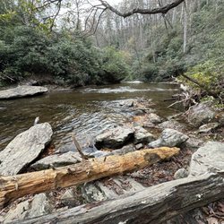
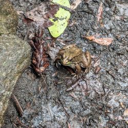
Great falls! Lots of water got here around noon and about 4 cars parked along the road. Still room to park and check it out. Photographed the falls and decided to walk the trail to the covered bridge MUD CREEK FALLS TO ESTATOAH FALLS. Great little trail, easy all the way. Nice and wide you could push a stroller most of the way to the falls. Just a couple sketchy places. (1) foot bridge, not really as much a bridge as a couple 2x12's nailed together. (2) a couple muddy spots where water is running over the trail (3) wash out at the covered bridge solved by a 2x12 walk board. So if you are pushing a stroller bring a helper. Otherwise put on your hiking shoes and hit the trail.

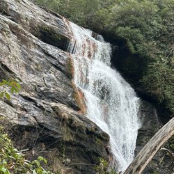
Mud Creek Falls is also known as 'LITTLE' Estatoah Falls due to it being located on the same river as its much larger cousin Estatoah Falls (located downstream on private property). The Mud Creek Fall is easily accessible by car and requires no hiking, unless you consider the 75 foot walk from your vehicle down to the base of the falls hiking. It is approximately 90+ foot cascading waterfall that has several rock ledge shelves for you to explore and take pics from various angles. I came here on June 10th, 2017 with a group of eager hikers on our way to visit nearby Glen Falls. We all found Mud Creek Falls to be a super delightful waterfall that also featured a small parking area and picnic tables for those who want to camp out and stay a while. Mud Creek Falls has been a big hit with everyone I have brought here over the years, especially all of our first time hikers and particularly kids since it is easy to climb with little danger of injury. That being said, you should ALWAYS exercise caution when hiking ANY waterfall due to unstable rocks and slippery surfaces. Along the way, be sure to check out Mountain Junction General Store for cool old school candy selections and Victory Garden Produce where the boiled peanuts are some of the best I've ever had! Also, Although the larger Estatoah Falls is on private land, it is visible on your way to these falls from Hwy 246. Just look for a bald area midway up the mountain. ~ DIRECTIONS: Turn into Sky Valley Resort and then an immediate left onto Lost Valley Drive (which will change names to Sky Valley Way). Follow it approx. 1,000 yards to Tahoe Road and turn right. You will see a sign saying "to Mud Creek Falls". Follow Tahoe Road all the way to the waterfall parking area. Google MAPS shows Tahoe Road to be much longer on the map than it actually is in reality. ~ FINAL THOUGHTS IF you are a waterfall lover, Mud Creek Falls is a must for your photo collection. Beautiful waterfalls are not hard to come by in North Georgia and the Carolina's. There are over 100 gorgeous waterfalls of all types within 100 miles, but most require some level of hiking whether it be strenuous or moderate. This is one of the few that would be absolutely worthy of a hike, but fortunately doesn't require one! Enjoy PHOTOGRAPHER'S NOTE : Due to the waterfalls East to West flow, it is probably best to photograph late afternoon to avoid sun glare. NAVIGATION NOTE: Exact coordinates for the parking area are 34°59'02.2"N 83°20'01.2"W 2020 / 54


1 year ago
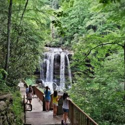
We parked on Tahoe Ln and you get out and the waterfall is right there! We ended up doing the tree walk which led us to an overlook and another waterfall by the road. It was about a 2 and half walk. Super beautiful. read more


Sorry TLC, but this waterfall is one you'll want to chase! A couple of friends introduced me to this beautiful waterfall on our way to hike a trail. We made a quick stop to take photos and take some time to appreciate the waterfall in all its glory. The waterfall is accessible by car and there's limited parking available just a few steps way. There's plenty of areas for good photo opps. You could even climb a few rocks to get closer to the top. Just be careful as it can get slippery, especially after it rains. Highly recommend checking out Mud Creek Falls. There's no hike involved, but there is a trail by the falls if you'd like to get some steps in! read more


Great falls! Lots of water got here around noon and about 4 cars parked along the road. Still room to park and check it out. Photographed the falls and decided to walk the trail to the covered bridge MUD CREEK FALLS TO ESTATOAH FALLS. Great little trail, easy all the way. Nice and wide you could push a stroller most of the way to the falls. Just a couple sketchy places. (1) foot bridge, not really as much a bridge as a couple 2x12's nailed together. (2) a couple muddy spots where water is running over the trail (3) wash out at the covered bridge solved by a 2x12 walk board. So if you are pushing a stroller bring a helper. Otherwise put on your hiking shoes and hit the trail. read more

6 years ago
Mud Creek Falls is also known as 'LITTLE' Estatoah Falls due to it being located on the same river as its much larger cousin Estatoah Falls (located downstream on private property). The Mud Creek Fall is easily accessible by car and requires no hiking, unless you consider the 75 foot walk from your vehicle down to the base of the falls hiking. It is approximately 90+ foot cascading waterfall that has several rock ledge shelves for you to explore and take pics from various angles. I came here on June 10th, 2017 with a group of eager hikers on our way to visit nearby Glen Falls. We all found Mud Creek Falls to be a super delightful waterfall that also featured a small parking area and picnic tables for those who want to camp out and stay a while. Mud Creek Falls has been a big hit with everyone I have brought here over the years, especially all of our first time hikers and particularly kids since it is easy to climb with little danger of injury. That being said, you should ALWAYS exercise caution when hiking ANY waterfall due to unstable rocks and slippery surfaces. Along the way, be sure to check out Mountain Junction General Store for cool old school candy selections and Victory Garden Produce where the boiled peanuts are some of the best I've ever had! Also, Although the larger Estatoah Falls is on private land, it is visible on your way to these falls from Hwy 246. Just look for a bald area midway up the mountain. ~ DIRECTIONS: Turn into Sky Valley Resort and then an immediate left onto Lost Valley Drive (which will change names to Sky Valley Way). Follow it approx. 1,000 yards to Tahoe Road and turn right. You will see a sign saying "to Mud Creek Falls". Follow Tahoe Road all the way to the waterfall parking area. Google MAPS shows Tahoe Road to be much longer on the map than it actually is in reality. ~ FINAL THOUGHTS IF you are a waterfall lover, Mud Creek Falls is a must for your photo collection. Beautiful waterfalls are not hard to come by in North Georgia and the Carolina's. There are over 100 gorgeous waterfalls of all types within 100 miles, but most require some level of hiking whether it be strenuous or moderate. This is one of the few that would be absolutely worthy of a hike, but fortunately doesn't require one! Enjoy PHOTOGRAPHER'S NOTE : Due to the waterfalls East to West flow, it is probably best to photograph late afternoon to avoid sun glare. NAVIGATION NOTE: Exact coordinates for the parking area are 34°59'02.2"N 83°20'01.2"W 2020 / 54 read more


4 years ago
6 years ago
4 years ago
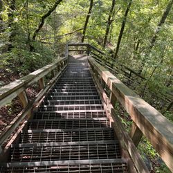
The falls and river themselves are beautiful--the path is a very doable and nicely cleared walking path that would be awesome to walk your dog on or even take your mountain bike. The trailhead at the main fall is a bit misleading to get to (you wind through the Sky Valley Golf Course for a bit before literally dead ending into it with little to no signage that I could find). It appears to have more than one access point, though I did not get to verify that. When we arrived after lunch at 1:30 there was one other car (a kind young woman and her leashed dog) but by the time we walked the trail and made our way back toward the main fall it was crawling with folks! So much so that my husband and i quickly left bc it was too crowded to even sit near the fall to snap a photo or really enjoy. So, for those who like a nice quiet hike and the sounds of rushing river and falls you will find it here for sure--just go in the morning on a weekday and try to beat the crowds! read more


3 years ago
More info about Mud Creek Falls
Tahoe Rd
Sky Valley, GA 30537
Directions
Hours
Outdoor Amenities
Ask the Community - Mud Creek Falls


Mud Creek Falls - hiking - Updated July 2026
Best of Sky Valley
People found Mud Creek Falls by searching for…
Hiking Trails With Waterfalls in Sky Valley, Georgia
Things to Do in Sky Valley, Georgia
Mountain Biking in Sky Valley, Georgia
Waterfalls and Swimming Holes in Sky Valley, Georgia
Photo Spots in Sky Valley, Georgia
Picnic Areas in Sky Valley, Georgia
Picnic Spots in Sky Valley, Georgia
Lookout Points in Sky Valley, Georgia
Scenic Overlook in Sky Valley, Georgia
Dog Friendly Trails in Sky Valley, Georgia
Running Trails in Sky Valley, Georgia
Easy Hikes in Sky Valley, Georgia
Waterfalls in Sky Valley, Georgia
Places to Take Pictures in Sky Valley, Georgia
Walking Trails in Sky Valley, Georgia
Scenic Views in Sky Valley, Georgia
Hiking Trails Kid Friendly in Sky Valley, Georgia
Off Road Trails in Sky Valley, Georgia
Off Leash Dog Hiking Trails in Sky Valley, Georgia
What to Do in Sky Valley, Georgia
Trending Searches in Sky Valley, GA
Browse Articles
Browse Nearby
BEST of Sky Valley, Georgia Restaurants near Mud Creek Falls
BEST of Sky Valley, Georgia Things to Do near Mud Creek Falls
BEST of Sky Valley, Georgia Swimming Holes near Mud Creek Falls
BEST of Sky Valley, Georgia Coffee near Mud Creek Falls
BEST of Sky Valley, Georgia Parks near Mud Creek Falls
BEST of Sky Valley, Georgia Snow Tubing near Mud Creek Falls
BEST of Sky Valley, Georgia Breakfast near Mud Creek Falls
BEST of Sky Valley, Georgia Ski Resorts near Mud Creek Falls
BEST of Sky Valley, Georgia Campgrounds near Mud Creek Falls
Browse Brands
Related Searches in Sky Valley, GA
Best Fishing Locations and Guides in Sky Valley, Georgia
Best Fun Things to Do in Sky Valley, Georgia
Best Nature Trails for Hiking in Sky Valley, Georgia
Best Places for Horseback Riding in Sky Valley, Georgia
Best Sledding Spots and Fun in Sky Valley, Georgia
Check Out Off Road Trails in Sky Valley, Georgia
Discover Dog Friendly Trails to Explore in Sky Valley, Georgia
Discover Popular Bike Trails in Sky Valley, Georgia
Discover Scenic Mountain Bike Trails Near Sky Valley, Georgia
Discover Top Nature Parks to Visit in Sky Valley, Georgia
Discover a Hiking Trail in Sky Valley, Georgia
Discover the Best Night Hike Trails in Sky Valley, Georgia
Dog-Friendly Hikes With Dogs in Sky Valley, Georgia
Effective Stairs Workout Spots in Sky Valley, Georgia
Enjoy Camping Adventures Around Sky Valley, Georgia
Enjoy Exciting Mountain Biking Adventures in Sky Valley, Georgia
Enjoy Kayaking Adventures in Sky Valley, Georgia
Enjoy Scenic Night View Experiences in Sky Valley, Georgia
Enjoy Tent Camping Spots Around Sky Valley, Georgia
Enjoy the Best Tubing Experiences in Sky Valley, Georgia
Enjoy the Best Walking Trails in Sky Valley, Georgia
Exciting Cliff Jumping Spots in Sky Valley, Georgia
Experience Thrilling White Water Rafting in Sky Valley, Georgia
Explore Beautiful Parks and Green Spaces in Sky Valley, Georgia
Explore Bike Rentals Throughout Sky Valley, Georgia
Explore Easy Hikes Perfect for All in Sky Valley, Georgia
Explore Popular Campgrounds Near Sky Valley, Georgia
Explore Popular RV Parks Around Sky Valley, Georgia
Explore Popular Scenic Overlook Points in Sky Valley, Georgia
Explore Scenic Lakes to Visit in Sky Valley, Georgia
Explore the Best Boating Spots in Sky Valley, Georgia
Explore the Best Swimming Holes Around Sky Valley, Georgia
Family Friendly Hiking With Kids in Sky Valley, Georgia
Find Beautiful Views in Sky Valley, Georgia
Find Parks and Recreation Activities in Sky Valley, Georgia
Find Popular Ziplining Spots Around Sky Valley, Georgia
Find Top-Rated Disc Golf in Sky Valley, Georgia
Find the Best Playgrounds to Visit in Sky Valley, Georgia
Find the Best Scenic View Locations in Sky Valley, Georgia
Find the Best Swimming Pools in Sky Valley, Georgia Today
Hiking Trails With Waterfalls in Sky Valley, Georgia
Off Leash Dog Hiking Trails in Sky Valley, Georgia
Perfect Spots to Watch Sunset in Sky Valley, Georgia
Plan a Scenic Drive Route Near Sky Valley, Georgia
Popular Kids Activities in Sky Valley, Georgia
Popular Places to Take Pictures in Sky Valley, Georgia
Popular Things to Do in Sky Valley, Georgia
Top Running Trails to Explore in Sky Valley, Georgia
People who viewed Mud Creek Falls also viewed
Martin Creek Falls
3 reviews
High Shoals Falls Loop Trail
17 reviews
Upper Moccasin Creek Falls
2 reviews
Reedy Branch Falls Trailhead
4 reviews
Black Rock Mountain State Park
57 reviews
Mountain View Campground
9 reviews
Lake Chatuge
9 reviews
Southeastern Expeditions
61 reviews
Charlie Falls - Chinquapin
1 review
Big Bend Falls
1 review