Sid's Falls Photos


Recommended Reviews - Sid's Falls
Start your review...

4 years ago
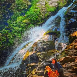
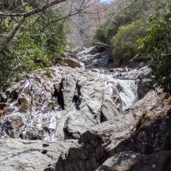
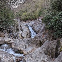
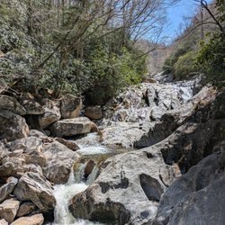
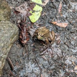
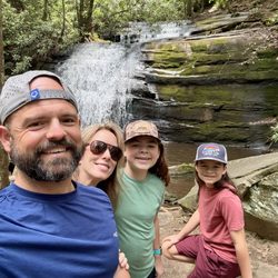
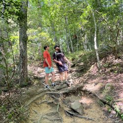
It is my honor to introduce Sid's Falls to the yelp community. [ THE STORY BEHIND THIS WATERFALL ] It is named after Sidney Holmes Ballenger, Jr., a man who loved waterfalls so much that he literally wrote the pioneering book on finding them in Oconee County, South Carolina. He died @ age 73 and a 1993 petition was sent to the U. S. Department of the Interior in hopes of naming one of the local UNNAMED waterfalls in his honor. By his side on many adventures was his friend Maxie Duke, who actually helped discover and officially name the waterfall currently known as Sid's Falls. While her 1993 petition was denied, the effort didn't end. In late 2014, Renee Hattenstein reapplied to the U.S. Board on Geographic Names to have the falls officially named Sid's Falls and in April of 2016, the name Sid's Falls was accepted by the board. *** I absolutely love chasing waterfalls despite TLC's song warning otherwise, so this story of friendship and determination to honor all he had done for Oconee County touched me deeply. I simply couldn't, as an avid hiker and purveyor of waterfall adventures, pass on the opportunity to visit Sid's. During my research of this waterfall duo I discovered a third member of their hiking team, a man named John Danner. Sadly I found an online obituary stating Maxie Lee Wright Duke passed away in December of 2020. Both her & John have waterfalls unofficially named in their honor in close proximity to Sid's Falls. As a matter of fact, Maxie Duke Falls shares most of the same trail and parking that you would use to visit Sid's Falls. [ THE EXPERIENCE ] I WANT TO GIVE FAIR WARNING right up front that while 95% of this trail is super easy, the final leg of the trail to the base of the falls is NOT FOR THE FAINT OF HEART or anyone not capable of using BOTH HANDS during the descent. You will absolutely need to posses basic skills in climbing and some upper body and leg strength. The trail to the bottom at minimum fits the CLASS 3 hike rating and the breakoff trail to Maxie Duke is practically CLASS 4 as ropes are available to assist climbers on the steep, steep terrain. PARK at the small area off Damascus Church Road between Damascus Baptist Church and Cool Springs Road (State Route S-37-797). Walk around the gate and enjoy approx. 1.4 miles of easy hiking on a wide old road that passes two open grassy fields along the way. The grade varies, but typically stays within a 5% differential. However, once the trail enters into the woods and narrows, it becomes steeper. You will reach a point where the trail forks right or left. RIGHT is to Sid's Falls and LEFT is to Maxie Duke Falls. Here is where either trail gets noticeable difficult as the grade to Sid's can exceed -34% (according to AllTrails). You will absolutely need both hands and a lower center of gravity to remain balanced, but the payoff is fantastic! Sid's is a beautiful 50+ foot natural wonder. NOTES: Plan on getting your feet wet to attain the best vantage for photos. I walked all the way to the base through the water and did not find the stone ledges to be particularly slippery. Still, proceed with caution and know your own ability. See pics to determine the water level during my hike. [ FINAL THOUGHTS ] When returning, you could also continue your adventure and follow the trial left of the split to Maxie Duke Falls. But again, BE FOREWARNED the trail to Maxie Duke is even steeper than to Sid's and may require the assistance of a preinstalled rope for most of the descent. Here you will also need to wet cross the creek to the right side of the falls in order to achieve the best view. It took us about 2 hours 20 minutes to hike from parking to both falls and back, which included rests and about 25 minutes of picture taking. ~ Round trip length to both: 3.3 miles ~ Elevation Gain: UNKNOWN (but probably 600+ feet) Overall a wonderful hike that will fool you into thinking it's easy for its majority... But this sweet thang goes GUANO LOCO on you the final 500 feet and leave you contemplating the foolishness of your life choices! LOL NOT RECOMMENDED for young children, dogs, anyone with balance issues or solo hikers because it is not a popular trail and injuring yourself would make the return ascent very difficult. 2022 / 72 read more


More info about Sid's Falls
Damascus Church Rd
Long Creek, SC 29658
Directions
Hours
Outdoor Amenities


Sid's Falls - hiking - Updated June 2026
Best of Long Creek
People found Sid's Falls by searching for…
Hiking Trails With Waterfalls in Long Creek, South Carolina
Places to Take Pictures in Long Creek, South Carolina
Things to Do in Long Creek, South Carolina
Off Road Trails in Long Creek, South Carolina
Waterfalls and Swimming Holes in Long Creek, South Carolina
Parks in Long Creek, South Carolina
Waterfalls in Long Creek, South Carolina
Easy Hikes in Long Creek, South Carolina
Beautiful Views in Long Creek, South Carolina
Walking Trails in Long Creek, South Carolina
Running Trails in Long Creek, South Carolina
View Points in Long Creek, South Carolina
Dog Friendly Trails in Long Creek, South Carolina
Dog Hiking Trails in Long Creek, South Carolina
Natural Hot Springs in Long Creek, South Carolina
Off Leash Dog Hikes in Long Creek, South Carolina
River Swimming in Long Creek, South Carolina
Things to Do at Night in Long Creek, South Carolina
Scenic Views in Long Creek, South Carolina
Hiking Trails Kid Friendly in Long Creek, South Carolina
Trail in Long Creek, South Carolina
State Park in Long Creek, South Carolina