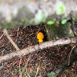
High Falls Trail Photos


More like High Falls Trail
Recommended Reviews - High Falls Trail
Start your review...

5 months ago
We went during the winter after a snow day, it was ethereal, beautiful, and worth it. To get to this point, it was a bit strenuous. You go down for a while, but the climb back up is tiresome. Be aware if you do not stay super active, it's harder than it seems, especially with colder temps + joint issues. In total we took roughly over 2 hours to walk down the trail, enjoy the waterfall, and walk back up. We took our time and didn't miss a thing in those 2 hours, but like I said, worth it! read more


3 years ago
This hike was nice and not to hard. Lots of people on a Friday when we went. We had to park in the overflow parking and walk down. After high falls, we went to the covered bridge and the lake. Those trails were much quieter. The lake wasn't to exciting, but it was a nice walk. The afternoon rain came on our way back to the car. read more
2 years ago
We had so much fun! beautiful place!! It was a great and very active trail. Wonderful place to come to in the summer read more
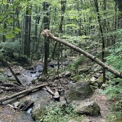
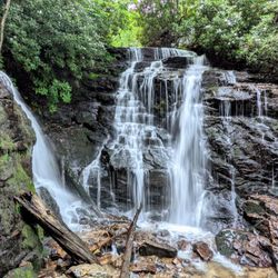
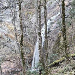
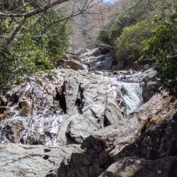
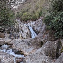
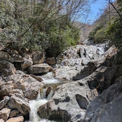
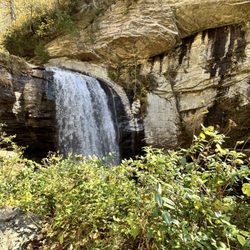
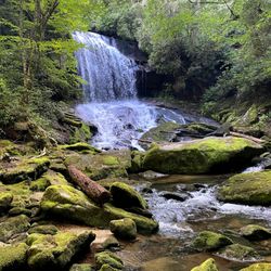
From the public access parking area, follow the gravel road for approximately 1/4 mile until you reach the High Falls trailhead. Turn right onto the trail and it's a little over 1/2 mile until you reach High Falls (aka Cullowhee Falls). Said trail consists of many steps, and it becomes quite rocky, as you pass the first cascade on the right, known as First Falls. This trail took over 10 months to construct, using local lumber and stones. It's mostly downhill on the way to Cullowhee Falls, which means you'll get a nice, albeit short workout on the way back. This, oftentimes, powerful cascade is located just below Glenville Dam, thus most of the water is normally employed in generating power far downstream. If you wish to see High Falls at peak flow, be sure to check Duke Energy's site for scheduled water release days. If you fancy photography, choose a non water release day, yet ensure that it has rained a decent amount prior to your visit, as this waterfall can slow to a trickle during dry periods. According to my Apple Watch, it's approximately 1.60 miles from the parking area to the falls and back. read more


More info about High Falls Trail
1966 Pine Creek Rd
Cullowhee, NC 28723
Directions
Hours
Outdoor Amenities


High Falls Trail - hiking - Updated June 2026
Best of Cullowhee
People found High Falls Trail by searching for…
Hiking Trails With Waterfalls in Cullowhee, North Carolina
Things to Do in Cullowhee, North Carolina
Parks in Cullowhee, North Carolina
Waterfalls in Cullowhee, North Carolina
Waterfalls and Swimming Holes in Cullowhee, North Carolina
Lakes & Ponds in Cullowhee, North Carolina
Scenic Views in Cullowhee, North Carolina
Off Road Trails in Cullowhee, North Carolina
Easy Hikes in Cullowhee, North Carolina
Walking Trails in Cullowhee, North Carolina
Running Trails in Cullowhee, North Carolina
Parks With Lakes in Cullowhee, North Carolina
Stairs Workout in Cullowhee, North Carolina
Trail in Cullowhee, North Carolina
Off Leash Dog Hikes in Cullowhee, North Carolina
Fun in Cullowhee, North Carolina
Secret Spots in Cullowhee, North Carolina
Things to Do on a Rainy Day in Cullowhee, North Carolina
River Swimming in Cullowhee, North Carolina
Places to Take Pictures in Cullowhee, North Carolina
Dog Hiking Trails in Cullowhee, North Carolina
Attraction in Cullowhee, North Carolina
Trending Searches in Cullowhee, NC
Black Owned Nail Salons near High Falls Trail
Boat Rental near High Falls Trail
Cliff Jumping near High Falls Trail
Day Trips near High Falls Trail
Dog Friendly Trails near High Falls Trail
Fishing Spots near High Falls Trail
Jet Ski Rental near High Falls Trail
Kayak Rental near High Falls Trail
Lakes & Ponds near High Falls Trail
Off Road Trails near High Falls Trail
Public Shower near High Falls Trail
River Swimming near High Falls Trail
River Tubing near High Falls Trail
Rock Quarry near High Falls Trail
Scenic Overlook near High Falls Trail
Secluded Spots near High Falls Trail
Splash Pad near High Falls Trail
Strawberry Picking near High Falls Trail
Swimming Holes near High Falls Trail
Swimming Lakes near High Falls Trail
U Pick Farms near High Falls Trail
Watch Sunset near High Falls Trail
Browse Articles
Browse Nearby
BEST of Cullowhee, North Carolina Restaurants near High Falls Trail
BEST of Cullowhee, North Carolina Things to Do near High Falls Trail
BEST of Cullowhee, North Carolina Coffee near High Falls Trail
BEST of Cullowhee, North Carolina Shopping near High Falls Trail
BEST of Cullowhee, North Carolina Breakfast near High Falls Trail
BEST of Cullowhee, North Carolina Beaches near High Falls Trail
BEST of Cullowhee, North Carolina Campgrounds near High Falls Trail
Browse Brands
Related Searches in Cullowhee, NC
Affordable Jet Ski Rental Options in Cullowhee, North Carolina
Affordable Kayak Rental Services in Cullowhee, North Carolina
Best Fishing Locations and Guides in Cullowhee, North Carolina
Best Fun Things to Do in Cullowhee, North Carolina
Best Places for Horseback Riding in Cullowhee, North Carolina
Best Spots for Star Gazing in Cullowhee, North Carolina
Check Out Off Road Trails in Cullowhee, North Carolina
Discover Dog Friendly Trails to Explore in Cullowhee, North Carolina
Discover a Hiking Trail in Cullowhee, North Carolina
Discover the Best Night Hike Trails in Cullowhee, North Carolina
Dog-Friendly Hikes With Dogs in Cullowhee, North Carolina
Enjoy Exciting Mountain Biking Adventures in Cullowhee, North Carolina
Enjoy River Tubing Adventures in Cullowhee, North Carolina
Enjoy Tent Camping Spots Around Cullowhee, North Carolina
Enjoy the Best Tubing Experiences in Cullowhee, North Carolina
Enjoy the Best Walking Trails in Cullowhee, North Carolina
Experience Thrilling White Water Rafting in Cullowhee, North Carolina
Explore Beautiful Botanical Gardens in Cullowhee, North Carolina
Explore Beautiful Parks and Green Spaces in Cullowhee, North Carolina
Explore Bike Rentals Throughout Cullowhee, North Carolina
Explore Easy Hikes Perfect for All in Cullowhee, North Carolina
Explore Family-Friendly Zoos and Wildlife in Cullowhee, North Carolina
Explore Fun Activities to Do in Cullowhee, North Carolina
Explore Popular Campgrounds Near Cullowhee, North Carolina
Explore Popular RV Parks Around Cullowhee, North Carolina
Explore Popular Scenic Overlook Points in Cullowhee, North Carolina
Explore Scenic Lakes to Visit in Cullowhee, North Carolina
Explore Secret Spots Worth Visiting in Cullowhee, North Carolina
Explore Top Dog Parks in Cullowhee, North Carolina Near You
Explore the Best Boating Spots in Cullowhee, North Carolina
Explore the Best Swimming Holes Around Cullowhee, North Carolina
Find Popular Ziplining Spots Around Cullowhee, North Carolina
Find Top Dog Swimming Spots in Cullowhee, North Carolina
Find Top Skate Parks in Cullowhee, North Carolina for All Skill Levels
Find the Best Playgrounds to Visit in Cullowhee, North Carolina
Hiking Trails With Waterfalls in Cullowhee, North Carolina
Off Leash Dog Hiking Trails in Cullowhee, North Carolina
Perfect Spots to Watch Sunset in Cullowhee, North Carolina
Popular Kids Activities in Cullowhee, North Carolina
Popular Things to Do in Cullowhee, North Carolina
Safe River Swimming Areas in Cullowhee, North Carolina
Top Climbing Spots and Gyms in Cullowhee, North Carolina
Top Paddleboarding Activities in Cullowhee, North Carolina
Top Running Trails to Explore in Cullowhee, North Carolina
Top Swimming Lakes to Enjoy in Cullowhee, North Carolina
Top Things to Do With Kids in Cullowhee, North Carolina
Top Things to Do With Teenagers in Cullowhee, North Carolina
Top-Rated Boat Rental Services in Cullowhee, North Carolina
Uncover the Best Secluded Spots Around Cullowhee, North Carolina
Walk Dog Friendly Hiking Trails in Cullowhee, North Carolina