Connestee Falls Photos


More like Connestee Falls
Recommended Reviews - Connestee Falls
Start your review...

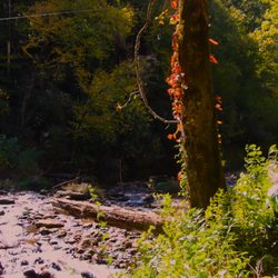
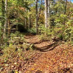
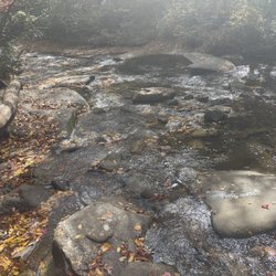
This was a surprise for me that there was a sweet little waterfall so close to my sister's new hometown. It's located in a park, yet there's no where to picnic. It's just the falls, unless I missed some hidden walking trails. Nonetheless, the falls are calming, and not at all congested like Looking Glass Falls in Pisgah National Park. read more


5 years ago
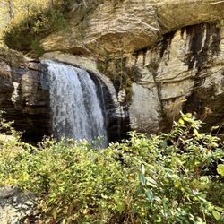
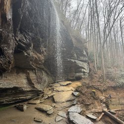
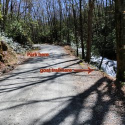
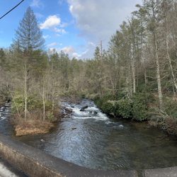
Undoubtedly a beautiful & scenic location as two creeks (Carson Creek and Batson Creek) separately fall into one of North Carolina's mini-gorges to form a third waterfall known as "the silver slip". The formation of the falls collectively is a "Y-shape" as Connestee Falls meets Batson Creek Falls to form Silver Slip Falls. It is one of the most unique waterfalls I've ever come across and would be much better photographed with a drone. There is an overlook on the Batson Creek side that faces Carson Creek, however, it is only accessible from a private trail in nearby Connestee Falls Subdivision. Thusly, the best view you will get as a non-resident will be from this nicely constructed boardwalk. The boardwalk hangs over Connestee Falls, so your view is very limited. Batson Creek Falls is visible, but not in its entirety as trees block most of the upper half of this nearly 100 foot tall sliding beauty. Topography maps show the elevation around Connestee Falls dropping roughly 65 feet before merging with Batson Creek Falls. Sliver Slip Falls is nearly impossible to see with the exception of the crest. [ FINAL THOUGHTS ] A staff member from our hotel told me about this waterfall and I'm so happy he did. It was our very last stop on a waterfall chasing weekend that included Upper White Water Falls, Toxaway Falls, Gorges State Park, Looking Glass Falls & Skinny Dip Falls. While it isn't a destination waterfall and rather difficult to properly view, it most certainly is a nice add-on when touring the area. 2021 / 67 read more


6 years ago
11 years ago
There is two beautiful water falls coming together. The falls were supposedly named for a Native American princess named "Connestee" in 1882 by Dr. F. A. Miles, owner of the Caesar's Head Hotel. A legend is told that the princess lost her life at the falls due to a relationship with an Englishman. read more

9 years ago
14 years ago
More info about Connestee Falls
Main Gate
Brevard, NC 28712
Directions
(828) 885-2737
Call Now
Hours
Outdoor Amenities
Ask the Community - Connestee Falls


Why does Yelp recommend reviews?
Connestee Falls - hiking - Updated June 2026
Best of Brevard
People found Connestee Falls by searching for…
Hiking Trails With Waterfalls in Brevard, North Carolina
Scenic Overlook in Brevard, North Carolina
Things to Do in Brevard, North Carolina
Scenic Drive in Brevard, North Carolina
Parks in Brevard, North Carolina
Waterfalls in Brevard, North Carolina
Secret Spots in Brevard, North Carolina
Beautiful Views in Brevard, North Carolina
Hiking With Kids in Brevard, North Carolina
Parks for Picnics in Brevard, North Carolina
Walking Trails in Brevard, North Carolina
View Points in Brevard, North Carolina
Playgrounds in Brevard, North Carolina
Lookout Points in Brevard, North Carolina
Scenic View in Brevard, North Carolina
Waterfalls and Swimming Holes in Brevard, North Carolina
Things to Do at Night in Brevard, North Carolina
Tours in Brevard, North Carolina
Off Leash Dog Hikes in Brevard, North Carolina
Scenic Restaurants in Brevard, North Carolina
Secluded Spots in Brevard, North Carolina
Off Road Trails in Brevard, North Carolina
Trending Searches in Brevard, NC
Black Owned Nail Salons near Connestee Falls
Boat Rental near Connestee Falls
Cliff Jumping near Connestee Falls
Day Trips near Connestee Falls
Fishing Spots near Connestee Falls
Jet Ski Rental near Connestee Falls
Kayak Rental near Connestee Falls
Lakes & Ponds near Connestee Falls
Off Road Trails near Connestee Falls
Outdoor Activities near Connestee Falls
Places To Walk Around near Connestee Falls
Public Shower near Connestee Falls
River Swimming near Connestee Falls
Rock Quarry near Connestee Falls
Running Trails near Connestee Falls
Scenic Night View near Connestee Falls
Scenic Overlook near Connestee Falls
Secluded Spots near Connestee Falls
Soccer Store near Connestee Falls
Splash Pad near Connestee Falls
Strawberry Picking near Connestee Falls
Sunrise View near Connestee Falls
Swimming Holes near Connestee Falls
Swimming Lakes near Connestee Falls
U Pick Farms near Connestee Falls
Watch Sunset near Connestee Falls
Browse Articles
Browse Nearby
BEST of Brevard, North Carolina Restaurants near Connestee Falls
BEST of Brevard, North Carolina Things to Do near Connestee Falls
BEST of Brevard, North Carolina Coffee near Connestee Falls
BEST of Brevard, North Carolina Breakfast near Connestee Falls
BEST of Brevard, North Carolina Attractions near Connestee Falls
Browse Brands
Related Searches in Brevard, NC
Affordable Kayak Rental Services in Brevard, North Carolina
Best Fishing Locations and Guides in Brevard, North Carolina
Best Places for Horseback Riding in Brevard, North Carolina
Best Waterfalls and Swimming Holes in Brevard, North Carolina
Check Out Off Road Trails in Brevard, North Carolina
Discover Dog Friendly Trails to Explore in Brevard, North Carolina
Discover Scenic Waterfall Spots in Brevard, North Carolina
Discover Top State Parks to Visit in Brevard, North Carolina
Discover a Hiking Trail in Brevard, North Carolina
Discover the Best Night Hike Trails in Brevard, North Carolina
Dog-Friendly Hikes With Dogs in Brevard, North Carolina
Enjoy Camping Adventures Around Brevard, North Carolina
Enjoy Exciting Mountain Biking Adventures in Brevard, North Carolina
Enjoy Kayaking Adventures in Brevard, North Carolina
Enjoy River Tubing Adventures in Brevard, North Carolina
Enjoy Tent Camping Spots Around Brevard, North Carolina
Enjoy a Beautiful Waterfall Hike in Brevard, North Carolina
Enjoy the Best Picnic Spots and Ideas in Brevard, North Carolina
Enjoy the Best Tubing Experiences in Brevard, North Carolina
Enjoy the Best Walking Trails in Brevard, North Carolina
Exciting Cliff Jumping Spots in Brevard, North Carolina
Experience Thrilling White Water Rafting in Brevard, North Carolina
Explore Beautiful Parks and Green Spaces in Brevard, North Carolina
Explore Easy Hikes Perfect for All in Brevard, North Carolina
Explore Fun Activities to Do in Brevard, North Carolina
Explore Popular Campgrounds Near Brevard, North Carolina
Explore the Best Beach Spots in Brevard, North Carolina
Explore the Best Boating Spots in Brevard, North Carolina
Explore the Best Swimming Holes Around Brevard, North Carolina
Explore the Best Trail Options in Brevard, North Carolina
Family Friendly Hiking With Kids in Brevard, North Carolina
Find Parks and Recreation Activities in Brevard, North Carolina
Find Popular Ziplining Spots Around Brevard, North Carolina
Find the Best Parks for Picnics in Brevard, North Carolina
Find the Best Scenic View Locations in Brevard, North Carolina
Great Places to Walk in Brevard, North Carolina
Hike the Popular Waterfall Trail in Brevard, North Carolina
Hiking Trails With Waterfalls in Brevard, North Carolina
Off Leash Dog Hiking Trails in Brevard, North Carolina
Plan Nature Center Visits in Brevard, North Carolina
Plan a Scenic Drive Route Near Brevard, North Carolina
Popular Outdoor Activities to Try in Brevard, North Carolina
Popular Picnic Spots to Visit in Brevard, North Carolina
Popular Things to Do in Brevard, North Carolina
Safe River Swimming Areas in Brevard, North Carolina
Top Climbing Spots and Gyms in Brevard, North Carolina
Top Paddleboarding Activities in Brevard, North Carolina
Top Running Trails to Explore in Brevard, North Carolina
People who viewed Connestee Falls also viewed
Pearson's Falls and Glen
51 reviews
Moore Cove Falls
4 reviews
Little Bradley Falls
7 reviews
Jump Off Rock
29 reviews
Merry Falls
1 review
Hooker Falls Trailhead - Dupont State Forest
19 reviews
Daniel Ridge Falls
1 review
Thompson River Waterfalls
2 reviews
Caesars Head State Park
44 reviews
The Park at Flat Rock
17 reviews